2023 Indicators (SST, SAL, MSLP, Wind shear, Steering, Instability) and Day 16+ Models

This is the general tropical discussion area. Anyone can take their shot at predicting a storms path.

Moderator: S2k Moderators

Forum rules

The posts in this forum are NOT official forecasts and should not be used as such. They are just the opinion of the poster and may or may not be backed by sound meteorological data. They are NOT endorsed by any professional institution or STORM2K. For official information, please refer to products from the National Hurricane Center and National Weather Service.

Help Support Storm2K
Message
Author
Ianswfl
Category 1
Category 1
Posts: 482
Joined: Thu Mar 23, 2023 11:11 pm

Re: RE: Re: 2023 Indicators (SST, SAL, MSLP, Wind shear, Steering, Instability) and Day 16+ Models

#1621 Postby Ianswfl » Tue Sep 19, 2023 11:22 pm

Woofde wrote:
AnnularCane wrote:


I don't know what I'm looking at. :(
It's showing rising motion in the Atlantic and America's starting in October. Generally that would be favorable and not El ninoish. It seems pretty reasonable considering the absolute warmth of the Atlantic right now. The basin has finally started cooling (In large part thanks to all the Hurricanes taking a chunk out), but we are crazily enough currently still warmer than any other season's peak warmth.https://uploads.tapatalk-cdn.com/20230920/50d5b73e557612a9453af7856231859a.jpg


The areas that matter in the Atlantic in October are still boiling warm! The Gulf will cool a bit due to the clouds and the front but will still be above average by october standards.
0 likes   

WeatherBoy2000
Category 1
Category 1
Posts: 280
Joined: Mon Apr 10, 2023 9:29 am

Re: 2023 Indicators (SST, SAL, MSLP, Wind shear, Steering, Instability) and Day 16+ Models

#1622 Postby WeatherBoy2000 » Wed Sep 20, 2023 3:21 pm

 https://twitter.com/Climatologist49/status/1704547189127864544


Important to consider going into next year. For right now, shear in the Caribbean is below average despite the intensifying el nino:

 https://twitter.com/OSUWXGUY/status/1704494126593450245


0 likes   

User avatar
WalterWhite
Category 1
Category 1
Posts: 342
Joined: Fri Mar 17, 2023 5:53 pm

Re: 2023 Indicators (SST, SAL, MSLP, Wind shear, Steering, Instability) and Day 16+ Models

#1623 Postby WalterWhite » Wed Sep 20, 2023 3:24 pm

WeatherBoy2000 wrote:https://twitter.com/Climatologist49/status/1704547189127864544

Important to consider going into next year. For right now, shear in the Caribbean is below average despite the intensifying el nino:

https://twitter.com/OSUWXGUY/status/1704494126593450245


The Atlantic seems to be completely oblivious to the fact that there is a likely-to-be Strong El Niño in the Pacific right now. The God of the Atlantic seems to have been unable to adjust its Caribbean wind shear to appropriate levels for an El Niño.
0 likes   

WeatherBoy2000
Category 1
Category 1
Posts: 280
Joined: Mon Apr 10, 2023 9:29 am

Re: 2023 Indicators (SST, SAL, MSLP, Wind shear, Steering, Instability) and Day 16+ Models

#1624 Postby WeatherBoy2000 » Wed Sep 20, 2023 3:38 pm

WalterWhite wrote:
WeatherBoy2000 wrote:https://twitter.com/Climatologist49/status/1704547189127864544

Important to consider going into next year. For right now, shear in the Caribbean is below average despite the intensifying el nino:

https://twitter.com/OSUWXGUY/status/1704494126593450245


The Atlantic seems to be completely oblivious to the fact that there is a likely-to-be Strong El Niño in the Pacific right now. The God of the Atlantic seems to have been unable to adjust its Caribbean wind shear to appropriate levels for an El Niño.


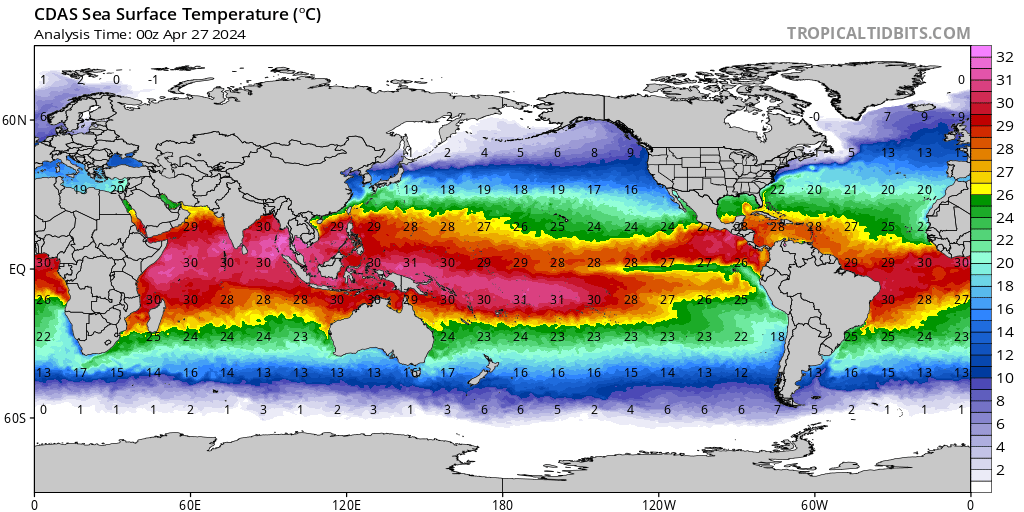
It's because the tropical Atlantic isn't really much cooler than the enso anomaly-wise. When contrasting the anomalies between the enso and tropical Atlantic, it is more like warm neutral/weak el nino than a strong one. A strong el nino would normally be well over 1c warmer than the Atlantic, not 0.5ish at most.

Image

The expanse of really warm tropical waters is much greater in the Atlantic than epac.
3 likes   

User avatar
Category5Kaiju
Category 5
Category 5
Posts: 4051
Joined: Thu Dec 24, 2020 12:45 pm
Location: Seattle

Re: 2023 Indicators (SST, SAL, MSLP, Wind shear, Steering, Instability) and Day 16+ Models

#1625 Postby Category5Kaiju » Wed Sep 20, 2023 9:04 pm

WeatherBoy2000 wrote:
WalterWhite wrote:
WeatherBoy2000 wrote:https://twitter.com/Climatologist49/status/1704547189127864544

Important to consider going into next year. For right now, shear in the Caribbean is below average despite the intensifying el nino:

https://twitter.com/OSUWXGUY/status/1704494126593450245


The Atlantic seems to be completely oblivious to the fact that there is a likely-to-be Strong El Niño in the Pacific right now. The God of the Atlantic seems to have been unable to adjust its Caribbean wind shear to appropriate levels for an El Niño.


It's because the tropical Atlantic isn't really much cooler than the enso anomaly-wise. When contrasting the anomalies between the enso and tropical Atlantic, it is more like warm neutral/weak el nino than a strong one. A strong el nino would normally be well over 1c warmer than the Atlantic, not 0.5ish at most.

https://www.tropicaltidbits.com/analysis/ocean/cdas-sflux_sst_global_1.png

The expanse of really warm tropical waters is much greater in the Atlantic than epac.


Good point there. There might be a formidable El Nino, but it's clear that the Atlantic has more areas that are simply warmer, raw temperature-wise, than the EPAC. This might be one of the main reasons why this El Nino seems to be doing jack squat in really limiting Atlantic activity.
0 likes   
Unless explicitly stated, all info in my posts is based on my own opinions and observations. Tropical storms and hurricanes can be extremely dangerous. Do not think you can beat Mother Nature. Refer to an accredited weather research agency or meteorologist if you need to make serious decisions regarding an approaching storm.

LarryWx
Category 5
Category 5
Posts: 6246
Joined: Sun Sep 07, 2003 2:04 pm
Location: GA

Re: 2023 Indicators (SST, SAL, MSLP, Wind shear, Steering, Instability) and Day 16+ Models

#1626 Postby LarryWx » Wed Sep 20, 2023 10:11 pm

Category5Kaiju wrote:
WeatherBoy2000 wrote:
WalterWhite wrote:
The Atlantic seems to be completely oblivious to the fact that there is a likely-to-be Strong El Niño in the Pacific right now. The God of the Atlantic seems to have been unable to adjust its Caribbean wind shear to appropriate levels for an El Niño.


It's because the tropical Atlantic isn't really much cooler than the enso anomaly-wise. When contrasting the anomalies between the enso and tropical Atlantic, it is more like warm neutral/weak el nino than a strong one. A strong el nino would normally be well over 1c warmer than the Atlantic, not 0.5ish at most.

https://www.tropicaltidbits.com/analysis/ocean/cdas-sflux_sst_global_1.png

The expanse of really warm tropical waters is much greater in the Atlantic than epac.


Good point there. There might be a formidable El Nino, but it's clear that the Atlantic has more areas that are simply warmer, raw temperature-wise, than the EPAC. This might be one of the main reasons why this El Nino seems to be doing jack squat in really limiting Atlantic activity.


El Niño hasn’t limited activity, but I think as I’ve said before that El Niño has resulted in a weak mean Bermuda High/WAR. Instead of an Azores-Bermuda High, it has been just an Azores High. By having a weak Bermuda High, there has been only one TC that moved W or WNW west of 74W so far this season with no end in sight yet (ignoring 18Z fantasy garbage). This has helped to protect the CONUS to sone extent.
2 likes   
Personal Forecast Disclaimer:
The posts in this forum are NOT official forecasts and should not be used as such. They are just the opinion of the poster and may or may not be backed by sound meteorological data. They are NOT endorsed by any professional institution or storm2k.org. For official information, please refer to the NHC and NWS products.

User avatar
WalterWhite
Category 1
Category 1
Posts: 342
Joined: Fri Mar 17, 2023 5:53 pm

Re: 2023 Indicators (SST, SAL, MSLP, Wind shear, Steering, Instability) and Day 16+ Models

#1627 Postby WalterWhite » Thu Sep 21, 2023 4:51 am

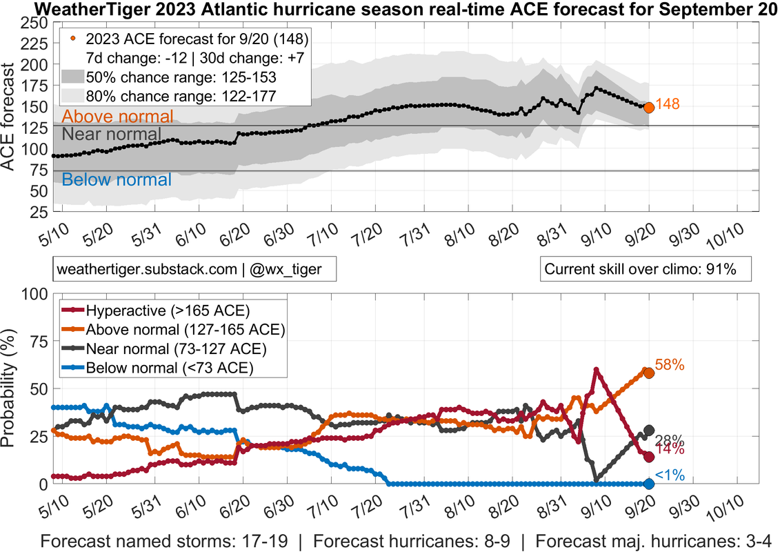
WeatherTiger is now extremely bearish for the rest of the season:

Image

WeatherTiger is only forecasting 17-19 storms, 8-9 hurricanes, 3-4 major hurricanes, and 148 ACE. What is causing this sudden bearishness?
0 likes   

WeatherBoy2000
Category 1
Category 1
Posts: 280
Joined: Mon Apr 10, 2023 9:29 am

Re: 2023 Indicators (SST, SAL, MSLP, Wind shear, Steering, Instability) and Day 16+ Models

#1628 Postby WeatherBoy2000 » Thu Sep 21, 2023 8:19 am

WalterWhite wrote:WeatherTiger is now extremely bearish for the rest of the season:

https://i.postimg.cc/KYnZ9YHj/https-substack-post-media-s3-amazonaws-com-public-images-7d6497ac-6502-4878-a448-611d3a3e6be5-2141.png

WeatherTiger is only forecasting 17-19 storms, 8-9 hurricanes, 3-4 major hurricanes, and 148 ACE. What is causing this sudden bearishness?


Activity has slowed quite significantly since late August into early September. Only one storm (Nigel) has formed in the last two week and has only produced 9 ace units since its formation. WeatherTiger's model has adjusted accordingly to this lack of output.
2 likes   

Ianswfl
Category 1
Category 1
Posts: 482
Joined: Thu Mar 23, 2023 11:11 pm

Re: 2023 Indicators (SST, SAL, MSLP, Wind shear, Steering, Instability) and Day 16+ Models

#1629 Postby Ianswfl » Thu Sep 21, 2023 1:56 pm

WeatherBoy2000 wrote:
WalterWhite wrote:WeatherTiger is now extremely bearish for the rest of the season:

https://i.postimg.cc/KYnZ9YHj/https-substack-post-media-s3-amazonaws-com-public-images-7d6497ac-6502-4878-a448-611d3a3e6be5-2141.png

WeatherTiger is only forecasting 17-19 storms, 8-9 hurricanes, 3-4 major hurricanes, and 148 ACE. What is causing this sudden bearishness?


Activity has slowed quite significantly since late August into early September. Only one storm (Nigel) has formed in the last two week and has only produced 9 ace units since its formation. WeatherTiger's model has adjusted accordingly to this lack of output.


hardly any Caribbean or Gulf activity this year. An uneventful season overall. Everything in the open atl and north atl.

I'm thinking next year is the big season for US landfalls.
0 likes   

User avatar
Ubuntwo
Category 5
Category 5
Posts: 1401
Age: 31
Joined: Thu Oct 05, 2017 10:41 pm

Re: 2023 Indicators (SST, SAL, MSLP, Wind shear, Steering, Instability) and Day 16+ Models

#1630 Postby Ubuntwo » Thu Sep 21, 2023 2:04 pm

WalterWhite wrote:WeatherTiger is now extremely bearish for the rest of the season:
WeatherTiger is only forecasting 17-19 storms, 8-9 hurricanes, 3-4 major hurricanes, and 148 ACE. What is causing this sudden bearishness?

Sudden bearishness? Extremely bearish? They're forecasting another 2-3 hurricanes and +30 ACE - putting us well into above average territory. I would wager the decrease from 'borderline hyperactive' is an ERCing Lee and Nigel recurving more quickly than models expected (reduced ACE output). We also have the MJO moving towards the maritime continent and WPAC.
Last edited by Ubuntwo on Thu Sep 21, 2023 2:10 pm, edited 1 time in total.
4 likes   
Kendall -> SLO -> PBC

Memorable Storms: Katrina (for its Florida landfall...) Wilma Matthew Irma

User avatar
Ubuntwo
Category 5
Category 5
Posts: 1401
Age: 31
Joined: Thu Oct 05, 2017 10:41 pm

Re: 2023 Indicators (SST, SAL, MSLP, Wind shear, Steering, Instability) and Day 16+ Models

#1631 Postby Ubuntwo » Thu Sep 21, 2023 2:08 pm

Ianswfl wrote:
WeatherBoy2000 wrote:
WalterWhite wrote:WeatherTiger is now extremely bearish for the rest of the season:

WeatherTiger is only forecasting 17-19 storms, 8-9 hurricanes, 3-4 major hurricanes, and 148 ACE. What is causing this sudden bearishness?


Activity has slowed quite significantly since late August into early September. Only one storm (Nigel) has formed in the last two week and has only produced 9 ace units since its formation. WeatherTiger's model has adjusted accordingly to this lack of output.


hardly any Caribbean or Gulf activity this year. An uneventful season overall. Everything in the open atl and north atl.

I'm thinking next year is the big season for US landfalls.

I suspect the extremely active past 6 or so years for the US has infected some with a 'landfall fever'. This pace of activity isn't really normal - it was not too long ago we went 12 years without a major landfall. Granted, some on this board may be too young to remember. Did we not have a major hurricane landfall in the US just a month ago?
Last edited by Ubuntwo on Thu Sep 21, 2023 3:37 pm, edited 1 time in total.
5 likes   
Kendall -> SLO -> PBC

Memorable Storms: Katrina (for its Florida landfall...) Wilma Matthew Irma

WeatherBoy2000
Category 1
Category 1
Posts: 280
Joined: Mon Apr 10, 2023 9:29 am

Re: 2023 Indicators (SST, SAL, MSLP, Wind shear, Steering, Instability) and Day 16+ Models

#1632 Postby WeatherBoy2000 » Thu Sep 21, 2023 2:16 pm

Ianswfl wrote:
WeatherBoy2000 wrote:
WalterWhite wrote:WeatherTiger is now extremely bearish for the rest of the season:

https://i.postimg.cc/KYnZ9YHj/https-substack-post-media-s3-amazonaws-com-public-images-7d6497ac-6502-4878-a448-611d3a3e6be5-2141.png

WeatherTiger is only forecasting 17-19 storms, 8-9 hurricanes, 3-4 major hurricanes, and 148 ACE. What is causing this sudden bearishness?


Activity has slowed quite significantly since late August into early September. Only one storm (Nigel) has formed in the last two week and has only produced 9 ace units since its formation. WeatherTiger's model has adjusted accordingly to this lack of output.


hardly any Caribbean or Gulf activity this year. An uneventful season overall. Everything in the open atl and north atl.

I'm thinking next year is the big season for US landfalls.


 https://twitter.com/MikeFischerWx/status/1704895230829355215


Hopefully this continues but it looks like October is going to remain rather favorable throughout the Caribbean/mdr. As CV season comes to a close, 60W into the Caribbean is where climo should favor intense activity (this assumes that you can trust climo this year). I won't be surprised if another disturbance or two tries to get going there despite the strong el nino.
0 likes   

User avatar
galaxy401
Category 5
Category 5
Posts: 2410
Age: 29
Joined: Sat Aug 25, 2012 9:04 pm
Location: Casa Grande, Arizona

Re: 2023 Indicators (SST, SAL, MSLP, Wind shear, Steering, Instability) and Day 16+ Models

#1633 Postby galaxy401 » Thu Sep 21, 2023 3:07 pm

WeatherBoy2000 wrote:
WalterWhite wrote:WeatherTiger is now extremely bearish for the rest of the season:

https://i.postimg.cc/KYnZ9YHj/https-substack-post-media-s3-amazonaws-com-public-images-7d6497ac-6502-4878-a448-611d3a3e6be5-2141.png

WeatherTiger is only forecasting 17-19 storms, 8-9 hurricanes, 3-4 major hurricanes, and 148 ACE. What is causing this sudden bearishness?


Activity has slowed quite significantly since late August into early September. Only one storm (Nigel) has formed in the last two week and has only produced 9 ace units since its formation. WeatherTiger's model has adjusted accordingly to this lack of output.


Uhhh no. Two hurricanes have formed in the past two weeks and we have two more disturbances to watch with one likely to become another hurricane. Slowed down significantly is simply not true.
6 likes   
Got my eyes on moving right into Hurricane Alley: Florida.

WeatherBoy2000
Category 1
Category 1
Posts: 280
Joined: Mon Apr 10, 2023 9:29 am

Re: 2023 Indicators (SST, SAL, MSLP, Wind shear, Steering, Instability) and Day 16+ Models

#1634 Postby WeatherBoy2000 » Thu Sep 21, 2023 3:47 pm

galaxy401 wrote:
WeatherBoy2000 wrote:
WalterWhite wrote:WeatherTiger is now extremely bearish for the rest of the season:

https://i.postimg.cc/KYnZ9YHj/https-substack-post-media-s3-amazonaws-com-public-images-7d6497ac-6502-4878-a448-611d3a3e6be5-2141.png

WeatherTiger is only forecasting 17-19 storms, 8-9 hurricanes, 3-4 major hurricanes, and 148 ACE. What is causing this sudden bearishness?


Activity has slowed quite significantly since late August into early September. Only one storm (Nigel) has formed in the last two week and has only produced 9 ace units since its formation. WeatherTiger's model has adjusted accordingly to this lack of output.


Uhhh no. Two hurricanes have formed in the past two weeks and we have two more disturbances to watch with one likely to become another hurricane. Slowed down significantly is simply not true.


I wasn't talking about actual activity, I was explaining why WeatherTiger's ace output took such a plunge recently. From Gert to Margot (Aug 19th-Sept 7th) at least one storm would form every few days, however since then only Nigel has formed. The last 2 weeks have been quieter compared to that very active period.
0 likes   

Ianswfl
Category 1
Category 1
Posts: 482
Joined: Thu Mar 23, 2023 11:11 pm

Re: 2023 Indicators (SST, SAL, MSLP, Wind shear, Steering, Instability) and Day 16+ Models

#1635 Postby Ianswfl » Thu Sep 21, 2023 5:25 pm

WeatherBoy2000 wrote:
Ianswfl wrote:
WeatherBoy2000 wrote:
Activity has slowed quite significantly since late August into early September. Only one storm (Nigel) has formed in the last two week and has only produced 9 ace units since its formation. WeatherTiger's model has adjusted accordingly to this lack of output.


hardly any Caribbean or Gulf activity this year. An uneventful season overall. Everything in the open atl and north atl.

I'm thinking next year is the big season for US landfalls.


https://twitter.com/MikeFischerWx/status/1704895230829355215

Hopefully this continues but it looks like October is going to remain rather favorable throughout the Caribbean/mdr. As CV season comes to a close, 60W into the Caribbean is where climo should favor intense activity (this assumes that you can trust climo this year). I won't be surprised if another disturbance or two tries to get going there despite the strong el nino.


but the Caribbean for an active season has been a graveyard basically. Seems a lot drier than most years as well. While the waters down there are warmer than normal there just isnt much energy down there. So far the models look dead there into Oct.

Also the big gap in major landfalls was luck! Hurricane Ike had it been 90 miles north would have been a mega disaster for the US. Major hurricane for the Florida Keys and a strong cat4 into the Houston area. it would been epic.
0 likes   

tolakram
Admin
Admin
Posts: 19990
Age: 61
Joined: Sun Aug 27, 2006 8:23 pm
Location: Florence, KY (name is Mark)

Re: 2023 Indicators (SST, SAL, MSLP, Wind shear, Steering, Instability) and Day 16+ Models

#1636 Postby tolakram » Thu Sep 21, 2023 5:43 pm

Waves developed and moved north, nothing unusual. Weather Tiger needs to put some smoothing on those predictions, otherwise it will bounce up and down, much like this thread. :lol:
3 likes   
M a r k
- - - - -
Join us in chat: Storm2K Chatroom Invite. Android and IOS apps also available.

The posts in this forum are NOT official forecasts and should not be used as such. Posts are NOT endorsed by any professional institution or STORM2K.org. For official information and forecasts, please refer to NHC and NWS products.

IcyTundra
Category 5
Category 5
Posts: 1205
Joined: Mon Jun 07, 2021 9:32 pm
Location: Dickinson, Texas

Re: 2023 Indicators (SST, SAL, MSLP, Wind shear, Steering, Instability) and Day 16+ Models

#1637 Postby IcyTundra » Thu Sep 21, 2023 6:14 pm

Ianswfl wrote:
WeatherBoy2000 wrote:
Ianswfl wrote:
hardly any Caribbean or Gulf activity this year. An uneventful season overall. Everything in the open atl and north atl.

I'm thinking next year is the big season for US landfalls.


https://twitter.com/MikeFischerWx/status/1704895230829355215

Hopefully this continues but it looks like October is going to remain rather favorable throughout the Caribbean/mdr. As CV season comes to a close, 60W into the Caribbean is where climo should favor intense activity (this assumes that you can trust climo this year). I won't be surprised if another disturbance or two tries to get going there despite the strong el nino.


but the Caribbean for an active season has been a graveyard basically. Seems a lot drier than most years as well. While the waters down there are warmer than normal there just isnt much energy down there. So far the models look dead there into Oct.

Also the big gap in major landfalls was luck! Hurricane Ike had it been 90 miles north would have been a mega disaster for the US. Major hurricane for the Florida Keys and a strong cat4 into the Houston area. it would been epic.


Very true Ike was bad enough as it was but no where close to what a worse case scenario what look like for the Houston/Galveston area. South Florida and Houston/Galveston have been very lucky with major hurricanes over these last several decades. There hasn't been a major hurricane landfall in Galvestion since 1983 with Alicia and for Southeast Florida they haven't been hit from the east with a major since Jeanne in 2004.
Last edited by IcyTundra on Thu Sep 21, 2023 6:16 pm, edited 1 time in total.
0 likes   

User avatar
Teban54
Category 5
Category 5
Posts: 3168
Joined: Sat May 19, 2018 1:19 pm

Re: 2023 Indicators (SST, SAL, MSLP, Wind shear, Steering, Instability) and Day 16+ Models

#1638 Postby Teban54 » Thu Sep 21, 2023 6:15 pm

Ianswfl wrote:
WeatherBoy2000 wrote:
Ianswfl wrote:
hardly any Caribbean or Gulf activity this year. An uneventful season overall. Everything in the open atl and north atl.

I'm thinking next year is the big season for US landfalls.


https://twitter.com/MikeFischerWx/status/1704895230829355215

Hopefully this continues but it looks like October is going to remain rather favorable throughout the Caribbean/mdr. As CV season comes to a close, 60W into the Caribbean is where climo should favor intense activity (this assumes that you can trust climo this year). I won't be surprised if another disturbance or two tries to get going there despite the strong el nino.


but the Caribbean for an active season has been a graveyard basically. Seems a lot drier than most years as well. While the waters down there are warmer than normal there just isnt much energy down there. So far the models look dead there into Oct.

Also the big gap in major landfalls was luck! Hurricane Ike had it been 90 miles north would have been a mega disaster for the US. Major hurricane for the Florida Keys and a strong cat4 into the Houston area. it would been epic.

Even if you ignore the two Caribbean geneses (Franklin and Idalia, both of which became majors later), the relatively quiet Caribbean is more of a result of waves moving further north before even reaching there (due to the weak Bermuda high), rather than hostile conditions in the Caribbean itself. An August CAG genesis certainly doesn't scream hostile to me.

In 2020, the only hurricane in the Caribbean up to September was Cat 1 Nana. We all know what happened in October and November. (Not saying 2023 will be a repeat)

And FWIW, models looked dead in mid-August just before Emily, Franklin, Gert, Harold and Idalia formed.
2 likes   

al78
Professional-Met
Professional-Met
Posts: 326
Joined: Thu Nov 01, 2018 12:20 pm

Re: 2023 Indicators (SST, SAL, MSLP, Wind shear, Steering, Instability) and Day 16+ Models

#1639 Postby al78 » Thu Sep 21, 2023 6:39 pm

IcyTundra wrote:Very true Ike was bad enough as it was but no where close to what a worse case scenario what look like for the Houston/Galveston area. South Florida and Houston/Galveston have been very lucky with major hurricanes over these last several decades. There hasn't been a major hurricane landfall in Galvestion since 1983 with Alicia and for Southeast Florida they haven't been hit from the east with a major since Jeanne in 2004.


As destructive as Ian was last year I still think Florida somewhat dodged a bullet. Had Ian followed earlier predictions and tracked further north, it could have sent a huge storm surge into Tampa Bay which would probably be much worse in terms of damage and death toll than what actually happened, bearing in mind Tampa has not had a major storm surge event for a long time and residents have no experience of such an event.
1 likes   


Return to “Talkin' Tropics”

Who is online

Users browsing this forum: Bing [Bot] and 70 guests