Oh my, waters warm like July, but is only Febuary.
https://twitter.com/MichaelRLowry/status/1757892634083758452
2024 Indicators: SST's, MSLP, Shear, SAL, Steering, Instability (Day 16+ Climate Models)
Moderator: S2k Moderators
Forum rules

The posts in this forum are NOT official forecasts and should not be used as such. They are just the opinion of the poster and may or may not be backed by sound meteorological data. They are NOT endorsed by any professional institution or STORM2K. For official information, please refer to products from the National Hurricane Center and National Weather Service.
-
cycloneye

- Admin

- Posts: 149261
- Age: 69
- Joined: Thu Oct 10, 2002 10:54 am
- Location: San Juan, Puerto Rico
Re: 2024 Indicators: SST's, MSLP, Shear, SAL, Steering, Instability, (Day 16+ Climate Models)
1 likes
Visit the Caribbean-Central America Weather Thread where you can find at first post web cams,radars
and observations from Caribbean basin members Click Here
and observations from Caribbean basin members Click Here

Re: 2024 Indicators: SST's, MSLP, Shear, SAL, Steering, Instability, (Day 16+ Climate Models)
DorkyMcDorkface wrote:cycloneye wrote:Yikes, look at that ridge with the C35 model.
https://twitter.com/cyclonicwx/status/1756670358604661207
https://twitter.com/AndyHazelton/status/1756673909376590331
https://twitter.com/AndyHazelton/status/1756679613462282535
Cruiser time? Been a while...
I doubt it honestly. Caribbean cruisers seem to be a thing of the past, can’t recall the last time we had one, think 2007? I’ve often times wondered if our changing climate has anything to do with it but can’t really see how it would but I’m still not sold our changing climate is making the Atlantic more favorable, I ultimately think it will do the opposite and maybe a lack of Caribbean Sea activity is a by product?
0 likes
-
WeatherBoy2000
- Category 1

- Posts: 460
- Joined: Mon Apr 10, 2023 9:29 am
Re: 2024 Indicators: SST's, MSLP, Shear, SAL, Steering, Instability, (Day 16+ Climate Models)
WiscoWx02 wrote:DorkyMcDorkface wrote:cycloneye wrote:Yikes, look at that ridge with the C35 model.
https://twitter.com/cyclonicwx/status/1756670358604661207
https://twitter.com/AndyHazelton/status/1756673909376590331
https://twitter.com/AndyHazelton/status/1756679613462282535
Cruiser time? Been a while...
I doubt it honestly. Caribbean cruisers seem to be a thing of the past, can’t recall the last time we had one, think 2007? I’ve often times wondered if our changing climate has anything to do with it but can’t really see how it would but I’m still not sold our changing climate is making the Atlantic more favorable, I ultimately think it will do the opposite and maybe a lack of Caribbean Sea activity is a by product?
There was a study by I think Klotzbach that analyzed the overall trend in tropical activity across all basins since the 80s and the Atlantic is the only one that showed an appreciable uptrend. Basins like the Wpac have been down trending. How much of this is due to climate age or the amo is up in the air, but since 2016 the only season that failed to achieve at least 130 ace was 2022. So far, I think climate change has been more favorable than not for Atlantic activity.
2 likes
-
DorkyMcDorkface

- Category 4

- Posts: 984
- Age: 28
- Joined: Mon Sep 30, 2019 1:32 pm
- Location: Mid-Atlantic
Re: 2024 Indicators: SST's, MSLP, Shear, SAL, Steering, Instability, (Day 16+ Climate Models)
WeatherBoy2000 wrote:WiscoWx02 wrote:DorkyMcDorkface wrote:Cruiser time? Been a while...
I doubt it honestly. Caribbean cruisers seem to be a thing of the past, can’t recall the last time we had one, think 2007? I’ve often times wondered if our changing climate has anything to do with it but can’t really see how it would but I’m still not sold our changing climate is making the Atlantic more favorable, I ultimately think it will do the opposite and maybe a lack of Caribbean Sea activity is a by product?
There was a study by I think Klotzbach that analyzed the overall trend in tropical activity across all basins since the 80s and the Atlantic is the only one that showed an appreciable uptrend. Basins like the Wpac have been down trending. How much of this is due to climate age or the amo is up in the air, but since 2016 the only season that failed to achieve at least 130 ace was 2022. So far, I think climate change has been more favorable than not for Atlantic activity.
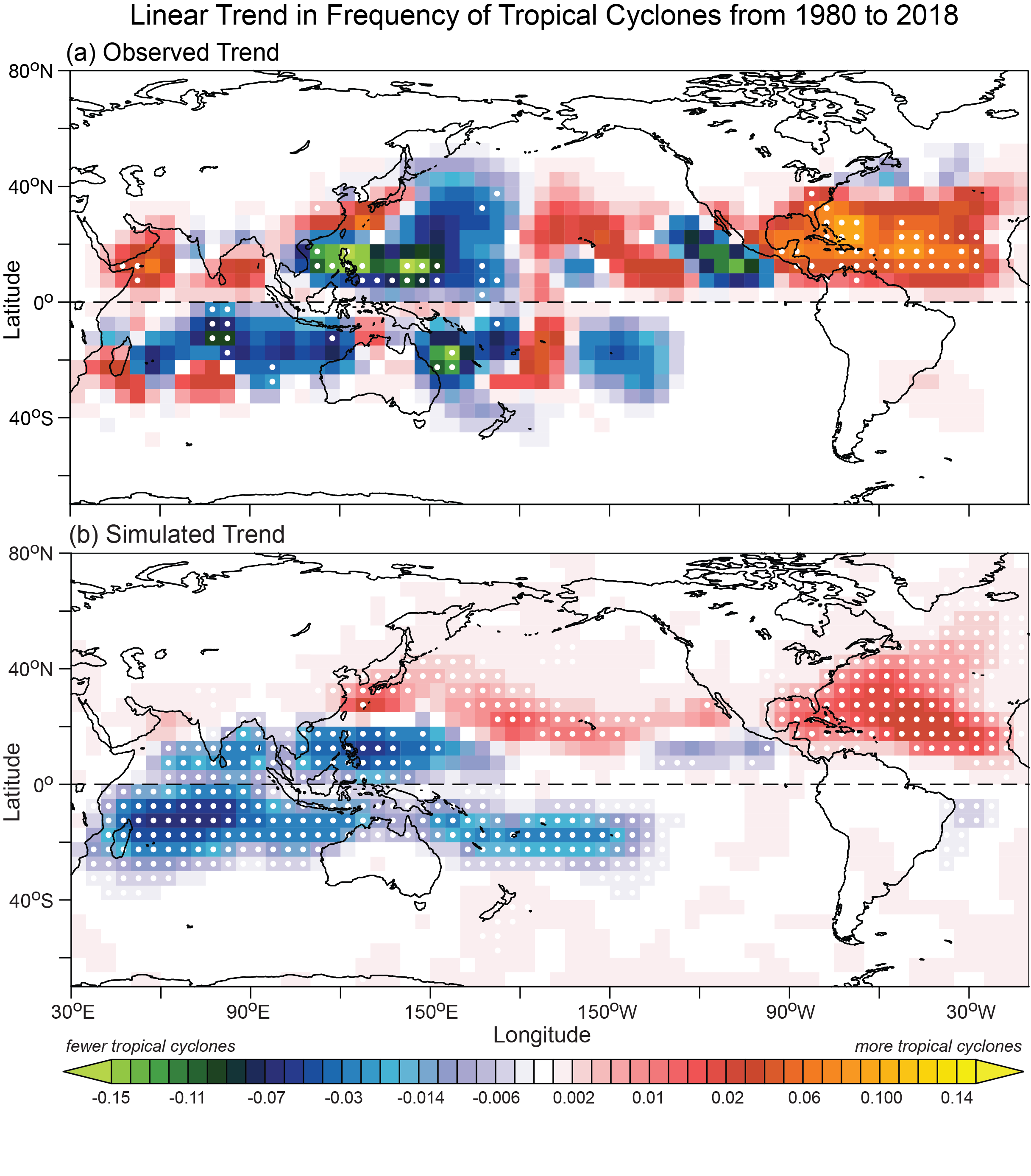
I think this is the study you're referring to, although it wasn't by Klotzbach. I remember reading it a while back:
Detected climatic change in global distribution of tropical cyclones
This is the graphic from that study I've seen make the rounds a lot regarding what you're alluding to:
2 likes
Please note the thougths expressed by this account are solely those of the user and are from a hobbyist perspective. For more comprehensive analysis, consult an actual professional meteorologist or meteorology agency.
Floyd 1999 | Isabel 2003 | Hanna 2008 | Irene 2011 | Sandy 2012 | Isaias 2020
Re: 2024 Indicators: SST's, MSLP, Shear, SAL, Steering, Instability, (Day 16+ Climate Models)
https://twitter.com/burgwx/status/1757603130735317141
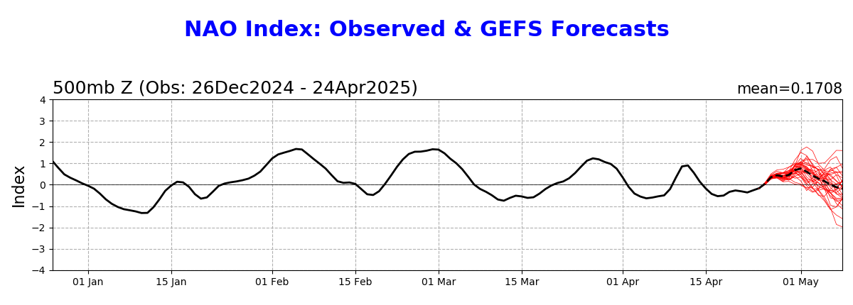
Models suddenly flipped to +NAO, that would erode some canary current warmth.
Models suddenly flipped to +NAO, that would erode some canary current warmth.
1 likes

Re: 2024 Indicators: SST's, MSLP, Shear, SAL, Steering, Instability, (Day 16+ Climate Models)
WiscoWx02 wrote:DorkyMcDorkface wrote:cycloneye wrote:Yikes, look at that ridge with the C35 model.
https://twitter.com/cyclonicwx/status/1756670358604661207
https://twitter.com/AndyHazelton/status/1756673909376590331
https://twitter.com/AndyHazelton/status/1756679613462282535
Cruiser time? Been a while...
I doubt it honestly. Caribbean cruisers seem to be a thing of the past, can’t recall the last time we had one, think 2007?
Irma says hi
0 likes
blonde stacey (xe/xem/xir)
-
JetFuel_SE

- Category 1
- Posts: 286
- Age: 26
- Joined: Thu Apr 30, 2020 3:57 pm
Re: 2024 Indicators: SST's, MSLP, Shear, SAL, Steering, Instability, (Day 16+ Climate Models)
DioBrando wrote:WiscoWx02 wrote:DorkyMcDorkface wrote:Cruiser time? Been a while...
I doubt it honestly. Caribbean cruisers seem to be a thing of the past, can’t recall the last time we had one, think 2007?
Irma says hi
Irma was certainly not a CC lol.
0 likes
-
Category5Kaiju

- Category 5

- Posts: 4330
- Joined: Thu Dec 24, 2020 12:45 pm
- Location: Seattle and Phoenix
Re: 2024 Indicators: SST's, MSLP, Shear, SAL, Steering, Instability, (Day 16+ Climate Models)
JetFuel_SE wrote:DioBrando wrote:WiscoWx02 wrote:
I doubt it honestly. Caribbean cruisers seem to be a thing of the past, can’t recall the last time we had one, think 2007?
Irma says hi
Irma was certainly not a CC lol.
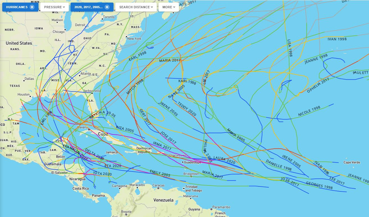
In a certain sense though, we could count Matthew, Eta, and Iota? But yeah, it's been a while since a major hurricane entered the ECAR and went all the way to the WCAR while maintaining such strength or even getting stronger
1 likes
Unless explicitly stated, all info in my posts is based on my own opinions and observations. Tropical storms and hurricanes can be extremely dangerous. Refer to an accredited weather research agency or meteorologist if you need to make serious decisions regarding an approaching storm.
-
DorkyMcDorkface
- Category 4
- Posts: 984
- Age: 28
- Joined: Mon Sep 30, 2019 1:32 pm
- Location: Mid-Atlantic
Re: 2024 Indicators: SST's, MSLP, Shear, SAL, Steering, Instability, (Day 16+ Climate Models)
JetFuel_SE wrote:DioBrando wrote:WiscoWx02 wrote:
I doubt it honestly. Caribbean cruisers seem to be a thing of the past, can’t recall the last time we had one, think 2007?
Irma says hi
Irma was certainly not a CC lol.
I guess there's technically no set criteria for a Caribbean Cruiser since it's an informal term but I think the most widely accepted definition is a TC which traverses the length of the Caribbean almost entirely as a hurricane. Irma went N of the Caribbean and passed over the Northern Leewards instead, so it would not meet those conditions.
2 likes
Please note the thougths expressed by this account are solely those of the user and are from a hobbyist perspective. For more comprehensive analysis, consult an actual professional meteorologist or meteorology agency.
Floyd 1999 | Isabel 2003 | Hanna 2008 | Irene 2011 | Sandy 2012 | Isaias 2020
-
TheWisestofAll

- Tropical Low

- Posts: 23
- Joined: Sun Dec 15, 2019 10:17 pm
Re: 2024 Indicators: SST's, MSLP, Shear, SAL, Steering, Instability, (Day 16+ Climate Models)
Category5Kaiju wrote:JetFuel_SE wrote:DioBrando wrote:
Irma says hi
Irma was certainly not a CC lol.
In a certain sense though, we could count Matthew, Eta, and Iota? But yeah, it's been a while since a major hurricane entered the ECAR and went all the way to the WCAR while maintaining such strength or even getting stronger
There aren't that many Caribbean Cruisers in the historical record to begin with. Most years don't see one, and the ones that do usually only feature one. I think there's some conflating going on with general Caribbean MH activity and actual legit Cruisers that come in from the open MDR.
6 likes
-
SFLcane

- S2K Supporter

- Posts: 10281
- Age: 48
- Joined: Sat Jun 05, 2010 1:44 pm
- Location: Lake Worth Florida
Re: 2024 Indicators: SST's, MSLP, Shear, SAL, Steering, Instability, (Day 16+ Climate Models)
Enso related but thought i would post here since its about the Atantic hurricane season.
https://x.com/hurricanetrack/status/1758145820627464686
https://x.com/hurricanetrack/status/1758145820627464686
1 likes
-
cycloneye
- Admin
- Posts: 149261
- Age: 69
- Joined: Thu Oct 10, 2002 10:54 am
- Location: San Juan, Puerto Rico
Re: 2024 Indicators: SST's, MSLP, Shear, SAL, Steering, Instability, (Day 16+ Climate Models)
JB has his analogs 1998,2005,2017 and 2020 for the 2024 season and continues with his 25-30 numbers.
https://twitter.com/BigJoeBastardi/status/1758188861769822334
https://twitter.com/BigJoeBastardi/status/1758189322195390732
https://twitter.com/BigJoeBastardi/status/1758188861769822334
https://twitter.com/BigJoeBastardi/status/1758189322195390732
1 likes
Visit the Caribbean-Central America Weather Thread where you can find at first post web cams,radars
and observations from Caribbean basin members Click Here
and observations from Caribbean basin members Click Here
-
CyclonicFury

- Category 5
- Posts: 2032
- Age: 27
- Joined: Sun Jul 02, 2017 12:32 pm
- Location: NC
- Contact:
Re: 2024 Indicators: SST's, MSLP, Shear, SAL, Steering, Instability, (Day 16+ Climate Models)
2021 had Hurricane Grace which could be considered a "Caribbean Cruiser" even though it was very weak for most of its path through the Caribbean. I don't think we can say Caribbean cruisers are a "thing of the past", but we are overdue for a hurricane that traverses the entire Caribbean at hurricane strength. To get one you need strong ridging and a well developed hurricane before the Lesser Antilles which just hasn't happened often. That would be most likely to occur during August, which hasn't seen a lot of intense deep tropics hurricanes in recent years. We've seen plenty of Cape Verde type hurricanes in recent years but most of them recurved because they formed in September when ridging is usually weaker.
6 likes
NCSU B.S. in Meteorology Class of 2021. Tropical weather blogger at http://www.cyclonicfury.com. My forecasts and thoughts are NOT official, for official forecasts please consult the National Hurricane Center.
-
cycloneye
- Admin
- Posts: 149261
- Age: 69
- Joined: Thu Oct 10, 2002 10:54 am
- Location: San Juan, Puerto Rico
Re: 2024 Indicators: SST's, MSLP, Shear, SAL, Steering, Instability, (Day 16+ Climate Models)
1 likes
Visit the Caribbean-Central America Weather Thread where you can find at first post web cams,radars
and observations from Caribbean basin members Click Here
and observations from Caribbean basin members Click Here
-
TheWisestofAll
- Tropical Low
- Posts: 23
- Joined: Sun Dec 15, 2019 10:17 pm
Re: 2024 Indicators: SST's, MSLP, Shear, SAL, Steering, Instability, (Day 16+ Climate Models)
cycloneye wrote:JB has his analogs 1998,2005,2017 and 2020 for the 2024 season and continues with his 25-30 numbers.
https://twitter.com/BigJoeBastardi/status/1758188861769822334
https://twitter.com/BigJoeBastardi/status/1758189322195390732
Why is it only this site that has CFS going +PDO? Literally nothing else has it developing, even the CFS on other sites and used officially in the CPC ENSO reports do not forecast a +PDO. What is going on here?
1 likes
-
DorkyMcDorkface
- Category 4
- Posts: 984
- Age: 28
- Joined: Mon Sep 30, 2019 1:32 pm
- Location: Mid-Atlantic
Re: 2024 Indicators: SST's, MSLP, Shear, SAL, Steering, Instability, (Day 16+ Climate Models)
TheWisestofAll wrote:cycloneye wrote:JB has his analogs 1998,2005,2017 and 2020 for the 2024 season and continues with his 25-30 numbers.
https://twitter.com/BigJoeBastardi/status/1758188861769822334
https://twitter.com/BigJoeBastardi/status/1758189322195390732
Why is it only this site that has CFS going +PDO? Literally nothing else has it developing, even the CFS on other sites and used officially in the CPC ENSO reports do not forecast a +PDO. What is going on here?
Additionally the Niña depicted there looks more CP-based, which also isn't showing up on any other guidance as far as I'm concerned.
For reference this is the most recent CFS run on TT for ASO:

0 likes
Please note the thougths expressed by this account are solely those of the user and are from a hobbyist perspective. For more comprehensive analysis, consult an actual professional meteorologist or meteorology agency.
Floyd 1999 | Isabel 2003 | Hanna 2008 | Irene 2011 | Sandy 2012 | Isaias 2020
-
Blown Away

- S2K Supporter
- Posts: 10253
- Joined: Wed May 26, 2004 6:17 am
Re: 2024 Indicators: SST's, MSLP, Shear, SAL, Steering, Instability, (Day 16+ Climate Models)
cycloneye wrote:JB has his analogs 1998,2005,2017 and 2020 for the 2024 season and continues with his 25-30 numbers.
https://twitter.com/BigJoeBastardi/status/1758188861769822334
If JB is right, going to be a busy season on Storm2k!!
2 likes
Hurricane Eye Experience: David 79, Irene 99, Frances 04, Jeanne 04, Wilma 05… Hurricane Brush Experience: Andrew 92, Erin 95, Floyd 99, Matthew 16, Irma 17, Ian 22, Nicole 22…
-
cycloneye
- Admin
- Posts: 149261
- Age: 69
- Joined: Thu Oct 10, 2002 10:54 am
- Location: San Juan, Puerto Rico
Re: 2024 Indicators: SST's, MSLP, Shear, SAL, Steering, Instability, (Day 16+ Climate Models)
Another hot record broken. Incredible, what is going on.
https://twitter.com/BMcNoldy/status/1758523548736557142
https://twitter.com/BMcNoldy/status/1758527246502109200
https://twitter.com/BMcNoldy/status/1758523548736557142
https://twitter.com/BMcNoldy/status/1758527246502109200
1 likes
Visit the Caribbean-Central America Weather Thread where you can find at first post web cams,radars
and observations from Caribbean basin members Click Here
and observations from Caribbean basin members Click Here
-
cycloneye
- Admin
- Posts: 149261
- Age: 69
- Joined: Thu Oct 10, 2002 10:54 am
- Location: San Juan, Puerto Rico
SATL: 01Q - Subtropical Depression
https://twitter.com/AndyHazelton/status/1758499578993648009
https://twitter.com/cyclonicwx/status/1758507132679254219
https://twitter.com/cyclonicwx/status/1758507132679254219
0 likes
Visit the Caribbean-Central America Weather Thread where you can find at first post web cams,radars
and observations from Caribbean basin members Click Here
and observations from Caribbean basin members Click Here
-
WeatherBoy2000
- Category 1
- Posts: 460
- Joined: Mon Apr 10, 2023 9:29 am
Re: 2024 Indicators: SST's, MSLP, Shear, SAL, Steering, Instability, (Day 16+ Climate Models)
Looks like sst anomalies will finally level off and decline at least a bit as we went enter the second half of February due to a developing +NAO. I won't be surprised it's just another temporary blip, like with the previous +NAO phases recently.
2 likes
Who is online
Users browsing this forum: No registered users and 69 guests