Texas Spring 2024
Moderator: S2k Moderators
Forum rules

The posts in this forum are NOT official forecast and should not be used as such. They are just the opinion of the poster and may or may not be backed by sound meteorological data. They are NOT endorsed by any professional institution or STORM2K.
-
bubba hotep

- S2K Supporter

- Posts: 6014
- Joined: Wed Dec 28, 2016 1:00 am
- Location: Collin County Texas
-
cheezyWXguy

- Category 5

- Posts: 6282
- Joined: Mon Feb 13, 2006 12:29 am
- Location: Dallas, TX
Re: Texas Spring 2024
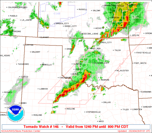
bubba hotep wrote:https://www.spc.noaa.gov/products/watch/ww0146_radar.gif
Surprised that graphic doesn’t have the PDS wording on it, since it is a PDS watch
0 likes
-
ElectricStorm

- Category 5
- Posts: 5146
- Age: 25
- Joined: Tue Aug 13, 2019 11:23 pm
- Location: Norman, OK
Re: Texas Spring 2024
First PDS watch for me since 2019
2 likes
B.S Meteorology, University of Oklahoma '25
Please refer to the NHC, NWS, or SPC for official information.
Please refer to the NHC, NWS, or SPC for official information.
-
bubba hotep
- S2K Supporter
- Posts: 6014
- Joined: Wed Dec 28, 2016 1:00 am
- Location: Collin County Texas
Re: Texas Spring 2024
The cell to the SW of Vernon looks nasty.
0 likes
Winter time post are almost exclusively focused on the DFW area.

Re: Texas Spring 2024
bubba hotep wrote:The cell to the SW of Vernon looks nasty.
Yeah, the southern one just west of Haskell, yikes. Knox City lookout!
0 likes
-
Texas Snowman

- Storm2k Moderator

- Posts: 6197
- Joined: Fri Jan 25, 2008 11:29 am
- Location: Denison, Texas
Re: Texas Spring 2024
0 likes
The above post and any post by Texas Snowman is NOT an official forecast and should not be used as such. It is just the opinion of the poster and may or may not be backed by sound meteorological data. It is NOT endorsed by any professional institution including storm2k.org. For official information, please refer to NWS products.
-
Anti-freeze
- Tropical Storm

- Posts: 109
- Joined: Tue Jan 02, 2024 8:26 pm
Re: Texas Spring 2024
ElectricStorm wrote:First PDS watch for me since 2019
Pretty Darn Scary pesky diatribe situation, with a chance of particularly dangerous spelling in the forum.
Can't say I'm thrilled about a second rise in tornado risk in DFW approaching 5am, making this a potential all nighter:
0 likes
-
Texas Snowman
- Storm2k Moderator
- Posts: 6197
- Joined: Fri Jan 25, 2008 11:29 am
- Location: Denison, Texas
Re: Texas Spring 2024
0 likes
The above post and any post by Texas Snowman is NOT an official forecast and should not be used as such. It is just the opinion of the poster and may or may not be backed by sound meteorological data. It is NOT endorsed by any professional institution including storm2k.org. For official information, please refer to NWS products.
-
bubba hotep
- S2K Supporter
- Posts: 6014
- Joined: Wed Dec 28, 2016 1:00 am
- Location: Collin County Texas
Re: Texas Spring 2024
Cpv17 wrote:bubba hotep wrote:The cell to the SW of Vernon looks nasty.
Yeah, the southern one just west of Haskell, yikes. Knox City lookout!
That one is really going now. That is some kind of hook!
ETA: Reports that this is on the ground an large (Although, I haven't seen any pics)

0 likes
Winter time post are almost exclusively focused on the DFW area.
-
bubba hotep
- S2K Supporter
- Posts: 6014
- Joined: Wed Dec 28, 2016 1:00 am
- Location: Collin County Texas
Re: Texas Spring 2024
"micro" discussion on those two cells
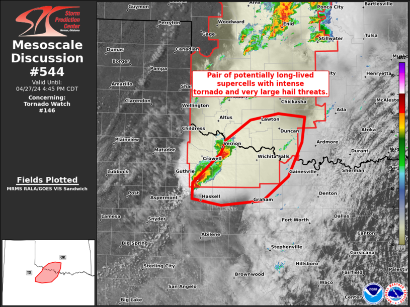
Mesoscale Discussion 0544
NWS Storm Prediction Center Norman OK
0319 PM CDT Sat Apr 27 2024
Areas affected...Western north TX and southwest OK
Concerning...Tornado Watch 146...
Valid 272019Z - 272145Z
The severe weather threat for Tornado Watch 146 continues.
SUMMARY...Pair of potentially long-lived supercells within the
southern portion of WW 146 may evolve with an intense tornado and
very large hail threat.
DISCUSSION...A potentially long-lived, slow-moving discrete
supercell is centered over Knox County, TX. This supercell appears
to be anchored along the far southern portion of the broader
convective plume that extends north across OK/KS. With full
insolation in the warm-moist sector inflow to its southeast, its
plausible that a long-lived supercell will persist for the next 2-3
hours. Amid MLCAPE of 3000 J/kg and mid 60s surface dew points to
its southeast, a cyclic tornadic supercell could evolve beyond the
very large hail threat with up to baseballs reported thus far. The
supercell to its northeast in Wilbarger County, TX will also have
potential to further intensify as it spreads towards and northwest
of the Wichita Falls vicinity, given 0-1 km SRH of 100-200 m2/s2 per
FDR VWP data.
..Grams.. 04/27/2024
...Please see http://www.spc.noaa.gov for graphic product...
ATTN...WFO...FWD...OUN...SJT...
0 likes
Winter time post are almost exclusively focused on the DFW area.
-
Texas Snowman
- Storm2k Moderator
- Posts: 6197
- Joined: Fri Jan 25, 2008 11:29 am
- Location: Denison, Texas
Re: Texas Spring 2024
0 likes
The above post and any post by Texas Snowman is NOT an official forecast and should not be used as such. It is just the opinion of the poster and may or may not be backed by sound meteorological data. It is NOT endorsed by any professional institution including storm2k.org. For official information, please refer to NWS products.
-
Texas Snowman
- Storm2k Moderator
- Posts: 6197
- Joined: Fri Jan 25, 2008 11:29 am
- Location: Denison, Texas
Re: Texas Spring 2024
Severe Weather Statement
National Weather Service Norman OK
332 PM CDT Sat Apr 27 2024
...A TORNADO WARNING REMAINS IN EFFECT UNTIL 345 PM CDT FOR SOUTHEASTERN KNOX COUNTY...
At 331 PM CDT, a large and extremely dangerous tornado was located 4 miles southwest of Rhineland, moving northeast at 25 mph.
This is a PARTICULARLY DANGEROUS SITUATION. TAKE COVER NOW!
HAZARD...Damaging tornado.
SOURCE...Radar indicated rotation.
IMPACT...You are in a life-threatening situation. Flying debris may be deadly to those caught without shelter. Mobile homes will be destroyed. Considerable damage to homes, businesses, and vehicles is likely and complete destruction is possible.
Locations impacted include... Munday, Knox City, and Rhineland.
PRECAUTIONARY/PREPAREDNESS ACTIONS...
To repeat, an extremely dangerous and potentially deadly tornado is developing. To protect your life, TAKE COVER NOW! Move to a storm shelter, safe room, or an interior room on the lowest floor of a sturdy building. Avoid windows. If you are outdoors, in a mobile home, or in a vehicle, move to the closest substantial shelter and protect yourself from flying debris.
Heavy rainfall may hide this tornado. Do not wait to see or hear the tornado. TAKE COVER NOW!
0 likes
The above post and any post by Texas Snowman is NOT an official forecast and should not be used as such. It is just the opinion of the poster and may or may not be backed by sound meteorological data. It is NOT endorsed by any professional institution including storm2k.org. For official information, please refer to NWS products.
-
Texas Snowman
- Storm2k Moderator
- Posts: 6197
- Joined: Fri Jan 25, 2008 11:29 am
- Location: Denison, Texas
Re: Texas Spring 2024
0 likes
The above post and any post by Texas Snowman is NOT an official forecast and should not be used as such. It is just the opinion of the poster and may or may not be backed by sound meteorological data. It is NOT endorsed by any professional institution including storm2k.org. For official information, please refer to NWS products.

Re: Texas Spring 2024
That storm in southeast Kansas is nasty.
0 likes
The above post and any post by Ntxw is NOT an official forecast and should not be used as such. It is just the opinion of the poster and may or may not be backed by sound meteorological data. It is NOT endorsed by any professional institution including Storm2k. For official information, please refer to NWS products.
Help support Storm2K!
-
ElectricStorm
- Category 5
- Posts: 5146
- Age: 25
- Joined: Tue Aug 13, 2019 11:23 pm
- Location: Norman, OK
Re: Texas Spring 2024
I'll be surprised if the cell west of OKC doesn't drop a strong tornado. All by itself with no other cells nearby. Looks like a new circulation is about to take over
0 likes
B.S Meteorology, University of Oklahoma '25
Please refer to the NHC, NWS, or SPC for official information.
Please refer to the NHC, NWS, or SPC for official information.
-
ElectricStorm
- Category 5
- Posts: 5146
- Age: 25
- Joined: Tue Aug 13, 2019 11:23 pm
- Location: Norman, OK
Re: Texas Spring 2024
Getting slightly concerned with that monster cell heading towards Wichita Falls. That looks nasty
0 likes
B.S Meteorology, University of Oklahoma '25
Please refer to the NHC, NWS, or SPC for official information.
Please refer to the NHC, NWS, or SPC for official information.
-
bubba hotep
- S2K Supporter
- Posts: 6014
- Joined: Wed Dec 28, 2016 1:00 am
- Location: Collin County Texas
-
Texas Snowman
- Storm2k Moderator
- Posts: 6197
- Joined: Fri Jan 25, 2008 11:29 am
- Location: Denison, Texas
Re: Texas Spring 2024
Tornado Warning
National Weather Service Norman OK
414 PM CDT Sat Apr 27 2024
The National Weather Service in Norman has issued a
* Tornado Warning for... Southeastern Wilbarger County in northern Texas... Northern Baylor County in northern Texas...
* Until 500 PM CDT.
* At 413 PM CDT, a confirmed large and extremely dangerous tornado was located 5 miles northeast of Red Springs, moving northeast at 35 mph.
This is a PARTICULARLY DANGEROUS SITUATION. TAKE COVER NOW!
HAZARD...Damaging tornado.
SOURCE...Weather spotters confirmed tornado.
IMPACT...You are in a life-threatening situation. Flying debris may be deadly to those caught without shelter. Mobile homes will be destroyed. Considerable damage to homes, businesses, and vehicles is likely and complete destruction is possible.
* Locations impacted include... Seymour, Red Springs, Lake Kemp, Mabelle, and Lake Diversion.
PRECAUTIONARY/PREPAREDNESS ACTIONS...
To repeat, an extremely dangerous and potentially deadly tornado is on the ground. To protect your life, TAKE COVER NOW! Move to a storm shelter, safe room or an interior room on the lowest floor of a sturdy building. Avoid windows. If you are outdoors, in a mobile home, or in a vehicle, move to the closest substantial shelter and protect yourself from flying debris.
&&
TIME...MOT...LOC 2113Z 235DEG 30KT 3366 9934
TORNADO...OBSERVED
TORNADO DAMAGE THREAT...CONSIDERABLE
MAX HAIL SIZE...2.75 IN
$$
MDU
0 likes
The above post and any post by Texas Snowman is NOT an official forecast and should not be used as such. It is just the opinion of the poster and may or may not be backed by sound meteorological data. It is NOT endorsed by any professional institution including storm2k.org. For official information, please refer to NWS products.
-
ElectricStorm
- Category 5
- Posts: 5146
- Age: 25
- Joined: Tue Aug 13, 2019 11:23 pm
- Location: Norman, OK
Re: Texas Spring 2024
I don't want to speak too early but it looks like the best case scenario might be playing out for most of C OK today, with thick cloud cover and poor lapse rates leading to an environment not great for storms. Hopefully that continues but for now I'm not very concerned for the OKC metro and surrounding areas. Still a few hours to go though.
0 likes
B.S Meteorology, University of Oklahoma '25
Please refer to the NHC, NWS, or SPC for official information.
Please refer to the NHC, NWS, or SPC for official information.