https://x.com/MJVentrice/status/1808121569429815537
2024 Indicators: SST's, MSLP, Shear, SAL, Steering, Instability (Day 16+ Climate Models)
Moderator: S2k Moderators
Forum rules

The posts in this forum are NOT official forecasts and should not be used as such. They are just the opinion of the poster and may or may not be backed by sound meteorological data. They are NOT endorsed by any professional institution or STORM2K. For official information, please refer to products from the National Hurricane Center and National Weather Service.
-
CyclonicFury

- Category 5

- Posts: 2032
- Age: 27
- Joined: Sun Jul 02, 2017 12:32 pm
- Location: NC
- Contact:
Re: 2024 Indicators: SST's, MSLP, Shear, SAL, Steering, Instability (Day 16+ Climate Models)
It does appear as if after Beryl the Atlantic will be mostly quiet for a couple weeks. I think we should see activity return by late July though when the more favorable MJO/CCKW returns.
2 likes
NCSU B.S. in Meteorology Class of 2021. Tropical weather blogger at http://www.cyclonicfury.com. My forecasts and thoughts are NOT official, for official forecasts please consult the National Hurricane Center.
Re: 2024 Indicators: SST's, MSLP, Shear, SAL, Steering, Instability (Day 16+ Climate Models)
CyclonicFury wrote:
It does appear as if after Beryl the Atlantic will be mostly quiet for a couple weeks. I think we should see activity return by late July though when the more favorable MJO/CCKW returns.
Hopefully. In the past ~15 years the tropical Atlantic is usually dead in July and first half of August no matter how favorable MJO is. There is a high chance that 2024 will end the lull..
2 likes
-
ElectricStorm

- Category 5
- Posts: 5139
- Age: 25
- Joined: Tue Aug 13, 2019 11:23 pm
- Location: Norman, OK
Re: 2024 Indicators: SST's, MSLP, Shear, SAL, Steering, Instability (Day 16+ Climate Models)
With Beryl hitting 145kts/934mb (which is impressive even for a peak season storm, let alone early July) that brings up the question of: will Beryl be the strongest storm of the season? Even with an expected hyperactive season ahead, we've seen some very active seasons not produce a Cat 5 (2010 and 2020 come to mind) so it'll be interesting to see if Beryl is still at the top when all is said and done.
My take is: in terms of pressure, no. 934 is pretty high for a Cat 5 and I think we'll see at least one, maybe multiple storms get lower than that. But in terms of wind, I'm not sure we'll see another 145kt storm this season. It sure would be something if we end up with a monster season but the strongest winds were on July 1
My take is: in terms of pressure, no. 934 is pretty high for a Cat 5 and I think we'll see at least one, maybe multiple storms get lower than that. But in terms of wind, I'm not sure we'll see another 145kt storm this season. It sure would be something if we end up with a monster season but the strongest winds were on July 1
1 likes
B.S Meteorology, University of Oklahoma '25
Please refer to the NHC, NWS, or SPC for official information.
Please refer to the NHC, NWS, or SPC for official information.
-
cycloneye

- Admin

- Posts: 149275
- Age: 69
- Joined: Thu Oct 10, 2002 10:54 am
- Location: San Juan, Puerto Rico
Re: 2024 Indicators: SST's, MSLP, Shear, SAL, Steering, Instability (Day 16+ Climate Models)
ElectricStorm wrote:With Beryl hitting 145kts/934mb (which is impressive even for a peak season storm, let alone early July) that brings up the question of: will Beryl be the strongest storm of the season? Even with an expected hyperactive season ahead, we've seen some very active seasons not produce a Cat 5 (2010 and 2020 come to mind) so it'll be interesting to see if Beryl is still at the top when all is said and done.
My take is: in terms of pressure, no. 934 is pretty high for a Cat 5 and I think we'll see at least one, maybe multiple storms get lower than that. But in terms of wind, I'm not sure we'll see another 145kt storm this season. It sure would be something if we end up with a monster season but the strongest winds were on July 1
You gave me a great idea. Going to make a poll.
4 likes
Visit the Caribbean-Central America Weather Thread where you can find at first post web cams,radars
and observations from Caribbean basin members Click Here
and observations from Caribbean basin members Click Here
-
Kingarabian

- S2K Supporter

- Posts: 16348
- Joined: Sat Aug 08, 2009 3:06 am
- Location: Honolulu, Hawaii
Re: 2024 Indicators: SST's, MSLP, Shear, SAL, Steering, Instability (Day 16+ Climate Models)
CyclonicFury wrote:
It does appear as if after Beryl the Atlantic will be mostly quiet for a couple weeks. I think we should see activity return by late July though when the more favorable MJO/CCKW returns.
Atlantic should remain active as long as the EPAC continues to struggle. Regardless of intraseasonal variability.
0 likes
RIP Kobe Bryant

Re: 2024 Indicators: SST's, MSLP, Shear, SAL, Steering, Instability (Day 16+ Climate Models)
CyclonicFury wrote:
It does appear as if after Beryl the Atlantic will be mostly quiet for a couple weeks. I think we should see activity return by late July though when the more favorable MJO/CCKW returns.
Pretty expected IMO. The last several seasons with a June or early July MDR/Caribbean storm ended up having a quiet spell for at least a few weeks in July (and all of August too, in 2022’s case). Even with Beryl going ballistic, an indicator of how favorable the basin is this season, I’m still expecting a quiet period for most of if not all of July, with things picking back up in August.
0 likes
Irene '11 Sandy '12 Hermine '16 5/15/2018 Derecho Fay '20 Isaias '20 Elsa '21 Henri '21 Ida '21
I am only a meteorology enthusiast who knows a decent amount about tropical cyclones. Look to the professional mets, the NHC, or your local weather office for the best information.
I am only a meteorology enthusiast who knows a decent amount about tropical cyclones. Look to the professional mets, the NHC, or your local weather office for the best information.

Re: 2024 Indicators: SST's, MSLP, Shear, SAL, Steering, Instability (Day 16+ Climate Models)
aspen wrote:CyclonicFury wrote:
It does appear as if after Beryl the Atlantic will be mostly quiet for a couple weeks. I think we should see activity return by late July though when the more favorable MJO/CCKW returns.
Pretty expected IMO. The last several seasons with a June or early July MDR/Caribbean storm ended up having a quiet spell for at least a few weeks in July (and all of August too, in 2022’s case). Even with Beryl going ballistic, an indicator of how favorable the basin is this season, I’m still expecting a quiet period for most of if not all of July, with things picking back up in August.
I think this has to do with the MJO. Most of the global models want to put it up in Phase 6 toward the middle of the month. However, the JMA and BOM (Australian) bring it into the lower part of the circle for possible reemergence into Phases 8 or 1. We'll have to see where it's at in 10-12 days and where it's heading. It might be a little quiet after 96L (which may or may not develop), but I don't think it's going to be an only-backloaded season like some other La Nina years. As it is, there's a fairly good chance we'll be past the D storm before July 10th.
3 likes
-
Deshaunrob17
- Tropical Storm

- Posts: 211
- Joined: Tue Aug 18, 2020 7:49 am
Re: 2024 Indicators: SST's, MSLP, Shear, SAL, Steering, Instability (Day 16+ Climate Models)
I would love to see the updated hurricane season forecasts. Beryl gave us a huge head start.
0 likes
-
cycloneye
- Admin
- Posts: 149275
- Age: 69
- Joined: Thu Oct 10, 2002 10:54 am
- Location: San Juan, Puerto Rico
Re: 2024 Indicators: SST's, MSLP, Shear, SAL, Steering, Instability (Day 16+ Climate Models)
Deshaunrob17 wrote:I would love to see the updated hurricane season forecasts. Beryl gave us a huge head start.
TSR comes out tommorow and CSU on July 9th.
3 likes
Visit the Caribbean-Central America Weather Thread where you can find at first post web cams,radars
and observations from Caribbean basin members Click Here
and observations from Caribbean basin members Click Here
-
cycloneye
- Admin
- Posts: 149275
- Age: 69
- Joined: Thu Oct 10, 2002 10:54 am
- Location: San Juan, Puerto Rico
Re: 2024 Indicators: SST's, MSLP, Shear, SAL, Steering, Instability (Day 16+ Climate Models)
1 likes
Visit the Caribbean-Central America Weather Thread where you can find at first post web cams,radars
and observations from Caribbean basin members Click Here
and observations from Caribbean basin members Click Here
-
Category5Kaiju

- Category 5
- Posts: 4330
- Joined: Thu Dec 24, 2020 12:45 pm
- Location: Seattle and Phoenix
Re: 2024 Indicators: SST's, MSLP, Shear, SAL, Steering, Instability (Day 16+ Climate Models)
I'm willing to bet that late July-early August, another impactful Cape Verde hurricane is going to happen. It could be another Beryl-like storm, or it could be like an Irma in cruising just north of the Caribbean Sea.
0 likes
Unless explicitly stated, all info in my posts is based on my own opinions and observations. Tropical storms and hurricanes can be extremely dangerous. Refer to an accredited weather research agency or meteorologist if you need to make serious decisions regarding an approaching storm.


Re: 2024 Indicators: SST's, MSLP, Shear, SAL, Steering, Instability (Day 16+ Climate Models)
Haven’t most active hurricane seasons seen a shift in the very warm SSTA’s westward as the season has gone on?
1 likes
Re: 2024 Indicators: SST's, MSLP, Shear, SAL, Steering, Instability (Day 16+ Climate Models)
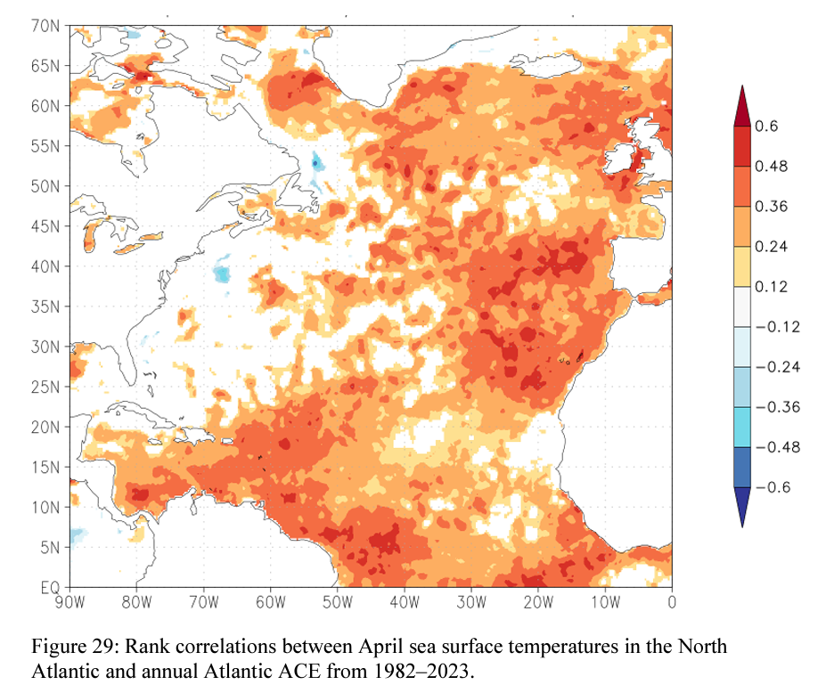
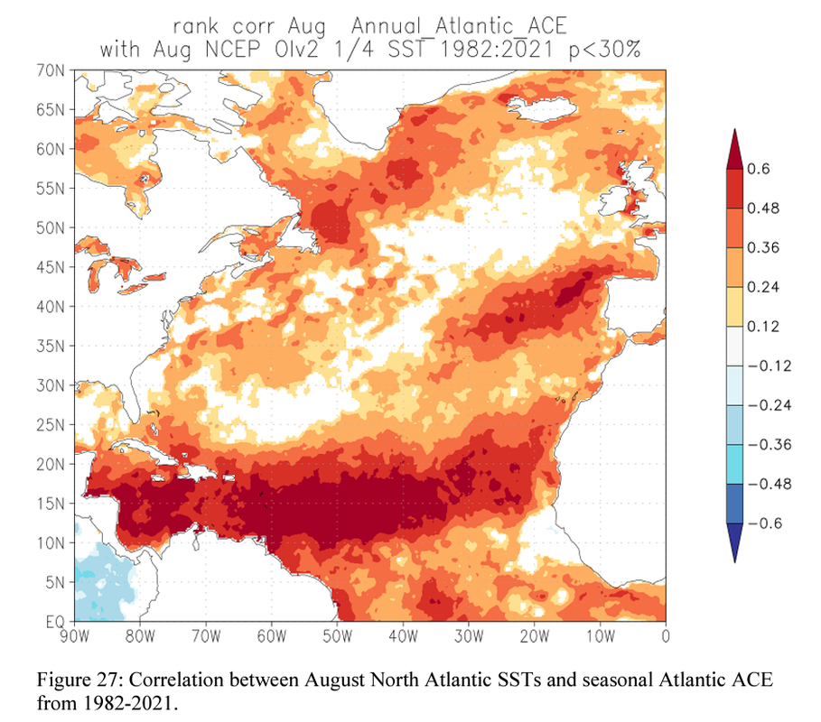
WiscoWx02 wrote:Haven’t most active hurricane seasons seen a shift in the very warm SSTA’s westward as the season has gone on?
Yes, that's my understanding as well and the reason why I'm personally not as concerned by Danny's tweet that I quoted earlier.
Below are two charts of correlation between seasonal ACE and SST anomalies at various times of the year, taken from CSU's forecasts. While April SSTs have a stronger focus on the Canary Current, by August, the correlation mostly comes from the MDR itself.
2 likes
TC naming lists: retirements and intensity
Most aggressive Advisory #1's in North Atlantic (cr. kevin for starting the list)
Most aggressive Advisory #1's in North Atlantic (cr. kevin for starting the list)

Re: 2024 Indicators: SST's, MSLP, Shear, SAL, Steering, Instability (Day 16+ Climate Models)
aspen wrote:CyclonicFury wrote:
It does appear as if after Beryl the Atlantic will be mostly quiet for a couple weeks. I think we should see activity return by late July though when the more favorable MJO/CCKW returns.
Pretty expected IMO. The last several seasons with a June or early July MDR/Caribbean storm ended up having a quiet spell for at least a few weeks in July (and all of August too, in 2022’s case). Even with Beryl going ballistic, an indicator of how favorable the basin is this season, I’m still expecting a quiet period for most of if not all of July, with things picking back up in August.
Even last year, we had nothing in the tropical Atlantic after Cindy for almost two months, with Don being the only system to develop at all during that time
0 likes
The above post is not official and should not be used as such. It is the opinion of the poster and may or may not be backed by sound meteorological data. It is not endorsed by any professional institution or storm2k.org. For official information, please refer to the NHC and NWS products.
-
CyclonicFury
- Category 5
- Posts: 2032
- Age: 27
- Joined: Sun Jul 02, 2017 12:32 pm
- Location: NC
- Contact:
Re: 2024 Indicators: SST's, MSLP, Shear, SAL, Steering, Instability (Day 16+ Climate Models)
Hammy wrote:aspen wrote:CyclonicFury wrote:It does appear as if after Beryl the Atlantic will be mostly quiet for a couple weeks. I think we should see activity return by late July though when the more favorable MJO/CCKW returns.
Pretty expected IMO. The last several seasons with a June or early July MDR/Caribbean storm ended up having a quiet spell for at least a few weeks in July (and all of August too, in 2022’s case). Even with Beryl going ballistic, an indicator of how favorable the basin is this season, I’m still expecting a quiet period for most of if not all of July, with things picking back up in August.
Even last year, we had nothing in the tropical Atlantic after Cindy for almost two months, with Don being the only system to develop at all during that time
2010, one of the top analogs for this year, also had Hurricane Alex in late June/early July, but only a few weak systems after that until Danielle formed on August 22. I'm not convinced we'll see July come close to 2005-level activity even with Beryl. I'd be shocked if we don't see another storm before the end of the month though.
0 likes
NCSU B.S. in Meteorology Class of 2021. Tropical weather blogger at http://www.cyclonicfury.com. My forecasts and thoughts are NOT official, for official forecasts please consult the National Hurricane Center.
-
Category5Kaiju
- Category 5
- Posts: 4330
- Joined: Thu Dec 24, 2020 12:45 pm
- Location: Seattle and Phoenix
Re: 2024 Indicators: SST's, MSLP, Shear, SAL, Steering, Instability (Day 16+ Climate Models)
So I've been kind of thinking at it lately, but I have some theories that could (at least) partially explain how the heck Beryl even happened. As in, Cat 5 in July. And, interestingly, I've noticed some parallels with it and 2005, as well as what other extremely warm Atlantic years (like 2010) lacked.
1. Everything else was dead. The WPAC was completely dead, and the EPAC as well. Not a single storm or disturbance. And it was like this for nearly all of June. I think this might have helped in some way to make the Atlantic ultra-favorable, arguably even moreso than 2005. On the other hand, 2010 had an extra-favorable June EPAC (including Cat 5 Celia there), and we basically only had Alex.
2. Extremely warm sst anomalies. Not only that though, but if you look at a map showing 2005 and 2024's sst anomaly distribution at around the same time near late June, you'll notice an interesting similarity. The bulk of the warmth wasn't in a fiery-C-shape (outlining the AMO, much like 2023 was) but was rather centered over the Caribbean and the heart of the central Atlantic and the MDR. The Canary Current wasn't all that warm compared to the former areas.
3. Previous active El Ninos and a slow transition to La Nina. 2004 was an extremely active El Nino year. So was 2023. There might have been something about this that made the Atlantic unusually favorable by this time of the year too. I'll also add 1980 in, as that year we just came out of a fairly strong season during El Nino (Cat 5 David and Cat 4 Frederic). In 1980, we had Cat 5 Allen, which, while not a July storm, was pretty close as it was an early August system.
4. Unremarkable Sahara Dust levels. Remember in 2020, the news about the "Godzilla" dust cloud during the summer? I don't remember hearing anything about anomalous levels of dust this summer. And I don't know if we had anything of that sort in 2005 either.
These might be things we should look for in future hurricane seasons, imho.
5 likes
Unless explicitly stated, all info in my posts is based on my own opinions and observations. Tropical storms and hurricanes can be extremely dangerous. Refer to an accredited weather research agency or meteorologist if you need to make serious decisions regarding an approaching storm.
-
WaveBreaking

- Category 2

- Posts: 717
- Joined: Sun Jun 30, 2024 11:33 am
- Location: US
Re: 2024 Indicators: SST's, MSLP, Shear, SAL, Steering, Instability (Day 16+ Climate Models)
Category5Kaiju wrote:
2. Extremely warm sst anomalies. Not only that though, but if you look at a map showing 2005 and 2024's sst anomaly distribution at around the same time near late June, you'll notice an interesting similarity.
Yeah 2024 and 2005 do look eerily similar currently, with the main difference being 2005 having a slight +PDO and full blown Atlantic Niña while 2024 has a -PDO and a less pronounced Atlantic Niña. I wonder if these differences will influence steering/favorability this year compared to 2005.


0 likes
I am NOT a professional meteorologist, so take all of my posts with a grain of salt. My opinions are mine and mine alone.
-
Hurricane2022

- Category 5
- Posts: 2016
- Joined: Tue Aug 23, 2022 11:38 pm
- Location: Araçatuba, Brazil
Re: 2024 Indicators: SST's, MSLP, Shear, SAL, Steering, Instability (Day 16+ Climate Models)
WaveBreaking wrote:Category5Kaiju wrote:
2. Extremely warm sst anomalies. Not only that though, but if you look at a map showing 2005 and 2024's sst anomaly distribution at around the same time near late June, you'll notice an interesting similarity.
Yeah 2024 and 2005 do look eerily similar currently, with the main difference being 2005 having a slight +PDO and full blown Atlantic Niña while 2024 has a -PDO and a less pronounced Atlantic Niña. I wonder if these differences will influence steering/favorability this year compared to 2005.
https://imgur.com/rbKSqaI.jpg
https://imgur.com/BQVfIPU.jpg
I wonder if that warm blob between Newfoundland and the Azores might affect activity in the tropics a bit in the coming months.
0 likes
Sorry for the bad English sometimes...!
For reliable and detailed information for any meteorological phenomenon, please consult the National Hurricane Center, Joint Typhoon Warning Center , or your local Meteo Center.
--------
ECCE OMNIA NOVA FACIAM (Ap 21,5).
For reliable and detailed information for any meteorological phenomenon, please consult the National Hurricane Center, Joint Typhoon Warning Center , or your local Meteo Center.
--------
ECCE OMNIA NOVA FACIAM (Ap 21,5).
Who is online
Users browsing this forum: Google Adsense [Bot] and 339 guests