WPAC: GAEMI - Post-Tropical

Moderator: S2k Moderators

Message
Author
User avatar
Hayabusa
Category 5
Category 5
Posts: 4244
Joined: Sun Sep 16, 2018 1:05 pm

Re: WPAC: GAEMI - Tropical Storm

#21 Postby Hayabusa » Sat Jul 20, 2024 2:22 am

Now GAEMI and large
Image
T2403(Gaemi)
Issued at 2024/07/20 07:05 UTC
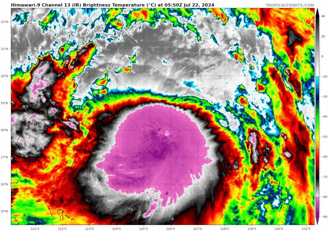
Analysis at 07/20 06 UTC
Grade TS
Scale Large
Intensity -
Center position N15°25′ (15.4°)
E128°05′ (128.1°)
Direction and speed of movement WNW 20 km/h (12 kt)
Central pressure 1002 hPa
Maximum sustained wind speed near center 18 m/s (35 kt)
Maximum wind gust speed 25 m/s (50 kt)
Radius of 30-kt wind area E650 km (350 NM)
W440 km (240 NM)
Forecast for 07/21 06 UTC
Grade TS
Intensity -
Center position of probability circle N16°55′ (16.9°)
E127°20′ (127.3°)
Direction and speed of movement NNW Slow
Central pressure 996 hPa
Maximum sustained wind speed near center 20 m/s (40 kt)
Maximum wind gust speed 30 m/s (60 kt)
Radius of probability circle 110 km (60 NM)
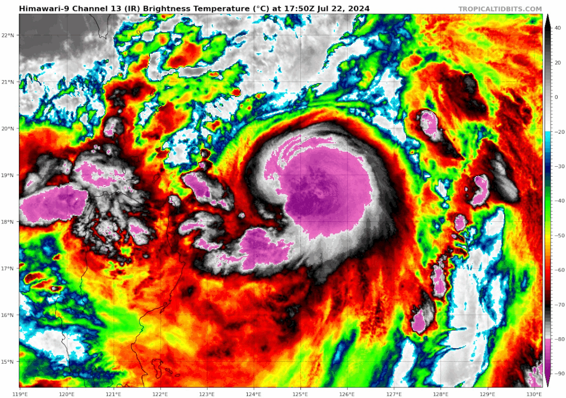
Forecast for 07/22 06 UTC
Grade STS
Intensity -
Center position of probability circle N18°05′ (18.1°)
E126°20′ (126.3°)
Direction and speed of movement NW Slow
Central pressure 990 hPa
Maximum sustained wind speed near center 25 m/s (50 kt)
Maximum wind gust speed 35 m/s (70 kt)
Radius of probability circle 200 km (110 NM)
Forecast for 07/23 06 UTC
Grade STS
Intensity -
Center position of probability circle N20°25′ (20.4°)
E126°00′ (126.0°)
Direction and speed of movement N 10 km/h (6 kt)
Central pressure 975 hPa
Maximum sustained wind speed near center 30 m/s (60 kt)
Maximum wind gust speed 45 m/s (85 kt)
Radius of probability circle 310 km (165 NM)
Radius of storm warning area 450 km (245 NM)
Forecast for 07/24 06 UTC
Grade TY
Intensity -
Center position of probability circle N23°50′ (23.8°)
E125°10′ (125.2°)
Direction and speed of movement N 15 km/h (9 kt)
Central pressure 965 hPa
Maximum sustained wind speed near center 35 m/s (70 kt)
Maximum wind gust speed 50 m/s (100 kt)
Radius of probability circle 330 km (180 NM)
Radius of storm warning area 520 km (280 NM)
Forecast for 07/25 06 UTC
Grade TY
Intensity -
Center position of probability circle N26°25′ (26.4°)
E123°10′ (123.2°)
Direction and speed of movement NNW 15 km/h (8 kt)
Central pressure 950 hPa
Maximum sustained wind speed near center 40 m/s (80 kt)
Maximum wind gust speed 60 m/s (115 kt)
Radius of probability circle 370 km (200 NM)
Radius of storm warning area 590 km (320 NM)
0 likes   
ヤンデレ女が寝取られるているのを見たい!!!
ECMWF ensemble NWPAC plots: https://ecmwfensnwpac.imgbb.com/
Multimodel NWPAC plots: https://multimodelnwpac.imgbb.com/
GFS Ensemble NWPAC plots (16 & 35 day forecast): https://gefsnwpac.imgbb.com/
Plots updated automatically

User avatar
Hayabusa
Category 5
Category 5
Posts: 4244
Joined: Sun Sep 16, 2018 1:05 pm

Re: WPAC: GAEMI - Tropical Storm

#22 Postby Hayabusa » Sat Jul 20, 2024 2:47 am

00Z
Image

Image
0 likes   
ヤンデレ女が寝取られるているのを見たい!!!
ECMWF ensemble NWPAC plots: https://ecmwfensnwpac.imgbb.com/
Multimodel NWPAC plots: https://multimodelnwpac.imgbb.com/
GFS Ensemble NWPAC plots (16 & 35 day forecast): https://gefsnwpac.imgbb.com/
Plots updated automatically

User avatar
cycloneye
Admin
Admin
Posts: 143863
Age: 68
Joined: Thu Oct 10, 2002 10:54 am
Location: San Juan, Puerto Rico

Re: WPAC: GAEMI - Tropical Storm

#23 Postby cycloneye » Sat Jul 20, 2024 7:44 am

0 likes   
Visit the Caribbean-Central America Weather Thread where you can find at first post web cams,radars
and observations from Caribbean basin members Click Here

Sciencerocks
Category 5
Category 5
Posts: 8903
Age: 39
Joined: Thu Jul 06, 2017 1:51 am

Re: WPAC: GAEMI - Tropical Storm

#24 Postby Sciencerocks » Sat Jul 20, 2024 10:15 am

0 likes   

User avatar
WaveBreaking
Category 2
Category 2
Posts: 562
Joined: Sun Jun 30, 2024 11:33 am
Location: US

Re: WPAC: GAEMI - Tropical Storm

#25 Postby WaveBreaking » Sat Jul 20, 2024 10:40 am

Convection is displaced W of the center, so it’s not surprising that Gaemi has a CCC pattern rn.

Image

Image
1 likes   
I am NOT a professional meteorologist, so take all of my posts with a grain of salt. My opinions are mine and mine alone.

User avatar
Hurricane2022
Category 5
Category 5
Posts: 1496
Joined: Tue Aug 23, 2022 11:38 pm
Location: Araçatuba, Brazil

Re: WPAC: GAEMI - Tropical Storm

#26 Postby Hurricane2022 » Sat Jul 20, 2024 12:58 pm

0 likes   
Sorry for the bad English sometimes...!
For reliable and detailed information for any meteorological phenomenon, please consult the National Hurricane Center, Joint Typhoon Warning Center , or your local Meteo Center.

--------

Una cvm Christo, pro Christo, et in Christo. Sit nomen Domini benedictvm.

User avatar
Hayabusa
Category 5
Category 5
Posts: 4244
Joined: Sun Sep 16, 2018 1:05 pm

Re: WPAC: GAEMI - Tropical Storm

#27 Postby Hayabusa » Sat Jul 20, 2024 2:46 pm

HFSA went nuclear
Image
3 likes   
ヤンデレ女が寝取られるているのを見たい!!!
ECMWF ensemble NWPAC plots: https://ecmwfensnwpac.imgbb.com/
Multimodel NWPAC plots: https://multimodelnwpac.imgbb.com/
GFS Ensemble NWPAC plots (16 & 35 day forecast): https://gefsnwpac.imgbb.com/
Plots updated automatically

shah83
Category 1
Category 1
Posts: 302
Joined: Sun Jul 31, 2016 4:55 pm

Re: WPAC: GAEMI - Tropical Storm

#28 Postby shah83 » Sat Jul 20, 2024 7:27 pm

Current dynamic models show an absolutely catastrophic rainfall disaster in Taiwan from Gaemi.
0 likes   

User avatar
cycloneye
Admin
Admin
Posts: 143863
Age: 68
Joined: Thu Oct 10, 2002 10:54 am
Location: San Juan, Puerto Rico

Re: WPAC: GAEMI - Tropical Storm

#29 Postby cycloneye » Sat Jul 20, 2024 7:33 pm

Wow.

Image
0 likes   
Visit the Caribbean-Central America Weather Thread where you can find at first post web cams,radars
and observations from Caribbean basin members Click Here

Sciencerocks
Category 5
Category 5
Posts: 8903
Age: 39
Joined: Thu Jul 06, 2017 1:51 am

Re: WPAC: GAEMI - Tropical Storm

#30 Postby Sciencerocks » Sun Jul 21, 2024 1:42 am

0 likes   

User avatar
cycloneye
Admin
Admin
Posts: 143863
Age: 68
Joined: Thu Oct 10, 2002 10:54 am
Location: San Juan, Puerto Rico

Re: WPAC: GAEMI - Tropical Storm

#31 Postby cycloneye » Sun Jul 21, 2024 8:12 am

0 likes   
Visit the Caribbean-Central America Weather Thread where you can find at first post web cams,radars
and observations from Caribbean basin members Click Here

User avatar
WaveBreaking
Category 2
Category 2
Posts: 562
Joined: Sun Jun 30, 2024 11:33 am
Location: US

Re: WPAC: GAEMI - Tropical Storm

#32 Postby WaveBreaking » Sun Jul 21, 2024 12:49 pm

Trying to fight off the dry air, but still disorganized.

Image
1 likes   

I am NOT a professional meteorologist, so take all of my posts with a grain of salt. My opinions are mine and mine alone.

User avatar
Hurricane2022
Category 5
Category 5
Posts: 1496
Joined: Tue Aug 23, 2022 11:38 pm
Location: Araçatuba, Brazil

Re: WPAC: GAEMI - Tropical Storm

#33 Postby Hurricane2022 » Sun Jul 21, 2024 9:47 pm

JMA upgraded Gaemi to Typhoon Status ( :?: :lol: :?: )
<Analysis at 09 JST, 2024/07/22>

Intensity/Category Typhoon

Center Position 17.4N 125.2E

Direction and speed of movement NNE Slow

Central pressure 980hPa

Maximum wind speed near center 35m/s (65kt)

Maximum wind gust speed 50m/s (95kt)
0 likes   
Sorry for the bad English sometimes...!
For reliable and detailed information for any meteorological phenomenon, please consult the National Hurricane Center, Joint Typhoon Warning Center , or your local Meteo Center.

--------

Una cvm Christo, pro Christo, et in Christo. Sit nomen Domini benedictvm.

User avatar
Teban54
Category 5
Category 5
Posts: 3168
Joined: Sat May 19, 2018 1:19 pm

Re: WPAC: GAEMI - Typhoon

#34 Postby Teban54 » Mon Jul 22, 2024 3:34 am

Shrimp incoming:
Image
1 likes   

User avatar
InfernoFlameCat
Category 5
Category 5
Posts: 2102
Age: 22
Joined: Mon Dec 14, 2020 10:52 am
Location: Buford, GA

Re: WPAC: GAEMI - Typhoon

#35 Postby InfernoFlameCat » Mon Jul 22, 2024 2:11 pm

I think this storm will become a supertyphoon. It has great conditions to work with.
1 likes   
I am by no means a professional. DO NOT look at my forecasts for official information or make decisions based on what I post.

Goal: to become a registered expert over tropical and subtropical cyclones.

User avatar
Teban54
Category 5
Category 5
Posts: 3168
Joined: Sat May 19, 2018 1:19 pm

Re: WPAC: GAEMI - Typhoon

#36 Postby Teban54 » Mon Jul 22, 2024 6:19 pm

Image
1 likes   

User avatar
1900hurricane
Category 5
Category 5
Posts: 6059
Age: 34
Joined: Fri Feb 06, 2015 12:04 pm
Location: Houston, TX
Contact:

Re: WPAC: GAEMI - Typhoon

#37 Postby 1900hurricane » Mon Jul 22, 2024 7:35 pm

Finally starting to curl more effectively now.
1 likes   
Contract Meteorologist. TAMU & MSST. Fiercely authentic, one of a kind. We are all given free will, so choose a life meant to be lived. We are the Masters of our own Stories.
Opinions expressed are mine alone.

Follow me on Twitter at @1900hurricane : Read blogs at https://1900hurricane.wordpress.com/

User avatar
REDHurricane
Category 1
Category 1
Posts: 394
Age: 27
Joined: Sun Jul 03, 2022 2:36 pm
Location: Northeast Pacific Ocean

Re: WPAC: GAEMI - Typhoon

#38 Postby REDHurricane » Mon Jul 22, 2024 10:46 pm

Wouldn't be surprised at all if this makes a run at the 920-910mb range as HAFS-A was forecasting yesterday I believe, it's already got that look to it
0 likes   

User avatar
Hurricane2022
Category 5
Category 5
Posts: 1496
Joined: Tue Aug 23, 2022 11:38 pm
Location: Araçatuba, Brazil

Re: WPAC: GAEMI - Typhoon

#39 Postby Hurricane2022 » Mon Jul 22, 2024 11:45 pm

Well grab the popcorn folks, the Gaemi show is about to begin.
Image
1 likes   
Sorry for the bad English sometimes...!
For reliable and detailed information for any meteorological phenomenon, please consult the National Hurricane Center, Joint Typhoon Warning Center , or your local Meteo Center.

--------

Una cvm Christo, pro Christo, et in Christo. Sit nomen Domini benedictvm.

User avatar
ElectricStorm
Category 5
Category 5
Posts: 5017
Age: 24
Joined: Tue Aug 13, 2019 11:23 pm
Location: Skiatook, OK / Norman, OK

Re: WPAC: GAEMI - Typhoon

#40 Postby ElectricStorm » Tue Jul 23, 2024 1:33 am

0z HWRF peaks at borderline Cat 5 (136kts)/910mb, makes landfall at 120-125kts/925mb. This HAFS-A run seems a little odd with storm movement but peaks at ~120kts/929mb before weakening at landfall. With how it looks currently, I think the current JTWC forecasted 100kt peak might be too low.
0 likes   
I am in no way a professional. Take what I say with a grain of salt as I could be totally wrong. Please refer to the NHC, NWS, or SPC for official information.

Boomer Sooner!


Return to “2024”

Who is online

Users browsing this forum: No registered users and 8 guests