
Atlantic is waking up
Moderator: S2k Moderators


MEANINGLESS_NUMBERS wrote:
How are you accessing the 12z models? I can only see up to 6z


Hurricane2022 wrote:These phantom tracks reminds me of something that happened in Aug 2005...
I really can wait very long to see another Katrina


kevin wrote:00z Euro ensemble with surprisingly and sudden strong support for a TC which forms in about 6 - 7 days. Let's see what the upcoming ensembles do and whether the other models also jump on board.
https://i.imgur.com/imKSXCB.png


REDHurricane wrote:kevin wrote:00z Euro ensemble with surprisingly and sudden strong support for a TC which forms in about 6 - 7 days. Let's see what the upcoming ensembles do and whether the other models also jump on board.
https://i.imgur.com/imKSXCB.png
Here's my heuristic for assessing these kinds of situations where one of the Euro/GFS is consistently predicting development 7-10 days out and the other isn't:
1) Does it make sense that something might try to develop in that specific area based on shear/SST/moisture/disturbance/climatology?
----> In this case, yes. Let's go through both models and check all of our boxes:
----------> A. Anomalously favorable wind shear conditions on both ensembles? Check
Euro 7 days out:
https://www.tropicaltidbits.com/analysis/models/eps/2024072400/eps_ashear_atl_29.png
GFS 7 days out:
https://www.tropicaltidbits.com/analysis/models/gfs-ens/2024072400/gfs-ens_ashear_atl_29.png
Euro 9 days out:
https://www.tropicaltidbits.com/analysis/models/eps/2024072400/eps_ashear_atl_37.png
GFS 9 days out:
https://www.tropicaltidbits.com/analysis/models/gfs-ens/2024072400/gfs-ens_ashear_atl_37.png
----------> B. SSTs conducive for tropical development? Check (obviously)
----------> C. Adequate atmospheric moisture content? Mostly check, dry air will still be present but we'll see if any moisture can consolidate to block it out
Euro 7 days out:
https://www.tropicaltidbits.com/analysis/models/eps/2024072400/eps_mslp_pwata_atl_29.png
GFS 7 days out:
https://www.tropicaltidbits.com/analysis/models/gfs-ens/2024072400/gfs-ens_mslp_pwata_atl_29.png
----------> D. Presence of a pre-existing disturbance as a possible spark for tropical cyclogenesis? Check
According to my totally amateur eye, it looks like maybe what's happening is a disturbance/area of convection emerging off Africa just north of Cabo Verde is going to be enhanced by an inflow of tropical moisture from the monsoon trough/ITCZ enough to the point where it may be able to take advantage of the favorable shear/SST conditions approaching the Caribbean despite the dry air surrounding it?
Euro forecast through 9 days:
https://media3.giphy.com/media/v1.Y2lkPTc5MGI3NjExY2ZlbzFxNDZvNnhkaXdjb3FyMjA2ZWl2MWp2NHJtZG1ib3BvaTAzbiZlcD12MV9pbnRlcm5hbF9naWZfYnlfaWQmY3Q9Zw/8ZnkiryIo9ZjMEBVbB/giphy.gif
Relevant area of convection circled in pink possibly?
https://media3.giphy.com/media/v1.Y2lkPTc5MGI3NjExbnZ2MjYxY2FqNHlwMmgzYzltOHdteWl0bWo3ZnBidXh2OGFtY3owciZlcD12MV9pbnRlcm5hbF9naWZfYnlfaWQmY3Q9Zw/t4bChqxpAJwqyobXes/giphy.gif
----------> E. Climatology? Not quite yet -- but as we all learned with Beryl, typical climatology might not really apply this year, so I'll check it off even though it's only July 24
2) Is the GFS ensemble predicting a sloppy CAG system that seemingly emerges out of thin air?
----> If the answer to this question is yes, then nothing is going to develop
3) Which solution do the Canadian and ICON favor?
----> Both models are showing a similar setup to the Euro/GFS, just no actual development yet except for maybe 2-3 members of the Canadian ensemble, so I'll call this one a tie for now
Taking all of these factors into account, though, I personally believe that the current Euro forecast will likely end up being more accurate and we'll see some sort of development from this disturbance. I won't say the name we're all thinking of because it's way too early for that... but people should be keeping a very close eye on this one for sure.


Category5Kaiju wrote:
The one red flag with the GFS right now is it seems to be spitting out cyclones after cyclones in the EPAC, thereby shutting down the Atlantic. I personally am very doubtful about this outcome, considering how poorly the EPAC has been performing and how we're not entering a warm ENSO phase. I also remember how the Euro ensembles correctly sniffed out Beryl before it formed and was one of the first models to do so, so I'm willing to hedge my money on the Euro ensembles if I had to.
Also...yeah, the K storm can go mind its own beeswax for the time being.
AnnularCane wrote:Category5Kaiju wrote:
The one red flag with the GFS right now is it seems to be spitting out cyclones after cyclones in the EPAC, thereby shutting down the Atlantic. I personally am very doubtful about this outcome, considering how poorly the EPAC has been performing and how we're not entering a warm ENSO phase. I also remember how the Euro ensembles correctly sniffed out Beryl before it formed and was one of the first models to do so, so I'm willing to hedge my money on the Euro ensembles if I had to.
Also...yeah, the K storm can go mind its own beeswax for the time being.
I am currently wondering if all this EPAC activity that the GFS is showing is actually supposed to be Atlantic activity, just misplaced due to GFS issues. Not that I'm expecting storm after storm in the Atlantic at the moment (not yet, maybe next month).

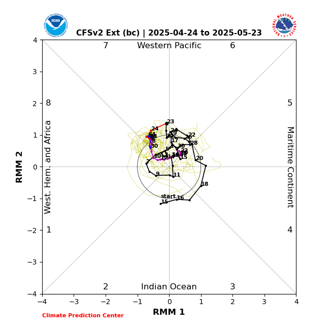
ScottNAtlanta wrote:Check out some other MJO models...CFSv2. Goes fully into 1 and 2
https://www.cpc.ncep.noaa.gov/products/precip/CWlink/MJO/CLIVAR/NCFS.png
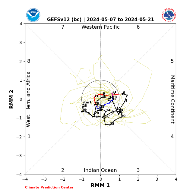
GEFS (bc) bias corrected
https://www.cpc.ncep.noaa.gov/products/precip/CWlink/MJO/CLIVAR/GEFS_BC.png
The trend is your friend, and the models have been trending towards the Atlantic favorable areas.

REDHurricane wrote:kevin wrote:00z Euro ensemble with surprisingly and sudden strong support for a TC which forms in about 6 - 7 days. Let's see what the upcoming ensembles do and whether the other models also jump on board.
https://i.imgur.com/imKSXCB.png
Here's my heuristic for assessing these kinds of situations where one of the Euro/GFS is consistently predicting development 7-10 days out and the other isn't:
1) Does it make sense that something might try to develop in that specific area based on shear/SST/moisture/disturbance/climatology?
----> In this case, yes. Let's go through both models and check all of our boxes:
----------> A. Anomalously favorable wind shear conditions on both ensembles? Check
Euro 7 days out:
https://www.tropicaltidbits.com/analysis/models/eps/2024072400/eps_ashear_atl_29.png
GFS 7 days out:
https://www.tropicaltidbits.com/analysis/models/gfs-ens/2024072400/gfs-ens_ashear_atl_29.png
Euro 9 days out:
https://www.tropicaltidbits.com/analysis/models/eps/2024072400/eps_ashear_atl_37.png
GFS 9 days out:
https://www.tropicaltidbits.com/analysis/models/gfs-ens/2024072400/gfs-ens_ashear_atl_37.png
----------> B. SSTs conducive for tropical development? Check (obviously)
----------> C. Adequate atmospheric moisture content? Mostly check, dry air will still be present but we'll see if any moisture can consolidate to block it out
Euro 7 days out:
https://www.tropicaltidbits.com/analysis/models/eps/2024072400/eps_mslp_pwata_atl_29.png
GFS 7 days out:
https://www.tropicaltidbits.com/analysis/models/gfs-ens/2024072400/gfs-ens_mslp_pwata_atl_29.png
----------> D. Presence of a pre-existing disturbance as a possible spark for tropical cyclogenesis? Check
According to my totally amateur eye, it looks like maybe what's happening is a disturbance/area of convection emerging off Africa just north of Cabo Verde is going to be enhanced by an inflow of tropical moisture from the monsoon trough/ITCZ enough to the point where it may be able to take advantage of the favorable shear/SST conditions approaching the Caribbean despite the dry air surrounding it?
Euro forecast through 9 days:
https://media3.giphy.com/media/v1.Y2lkPTc5MGI3NjExY2ZlbzFxNDZvNnhkaXdjb3FyMjA2ZWl2MWp2NHJtZG1ib3BvaTAzbiZlcD12MV9pbnRlcm5hbF9naWZfYnlfaWQmY3Q9Zw/8ZnkiryIo9ZjMEBVbB/giphy.gif
Relevant area of convection circled in pink possibly?
https://media3.giphy.com/media/v1.Y2lkPTc5MGI3NjExbnZ2MjYxY2FqNHlwMmgzYzltOHdteWl0bWo3ZnBidXh2OGFtY3owciZlcD12MV9pbnRlcm5hbF9naWZfYnlfaWQmY3Q9Zw/t4bChqxpAJwqyobXes/giphy.gif
----------> E. Climatology? Not quite yet -- but as we all learned with Beryl, typical climatology might not really apply this year, so I'll check it off even though it's only July 24
2) Is the GFS ensemble predicting a sloppy CAG system that seemingly emerges out of thin air?
----> If the answer to this question is yes, then nothing is going to develop
3) Which solution do the Canadian and ICON favor?
----> Both models are showing a similar setup to the Euro/GFS, just no actual development yet except for maybe 2-3 members of the Canadian ensemble, so I'll call this one a tie for now
Taking all of these factors into account, though, I personally believe that the current Euro forecast will likely end up being more accurate and we'll see some sort of development from this disturbance. I won't say the name we're all thinking of because it's way too early for that... but people should be keeping a very close eye on this one for sure.
Users browsing this forum: bird and 152 guests


