ATL: DEBBY - Post-Tropical - Discussion
Moderator: S2k Moderators
-
tropicwatch

- Category 5

- Posts: 3426
- Age: 62
- Joined: Sat Jun 02, 2007 10:01 am
- Location: The Villages, Florida
- Contact:
Re: ATL: INVEST 97L - Discussion (50/80)
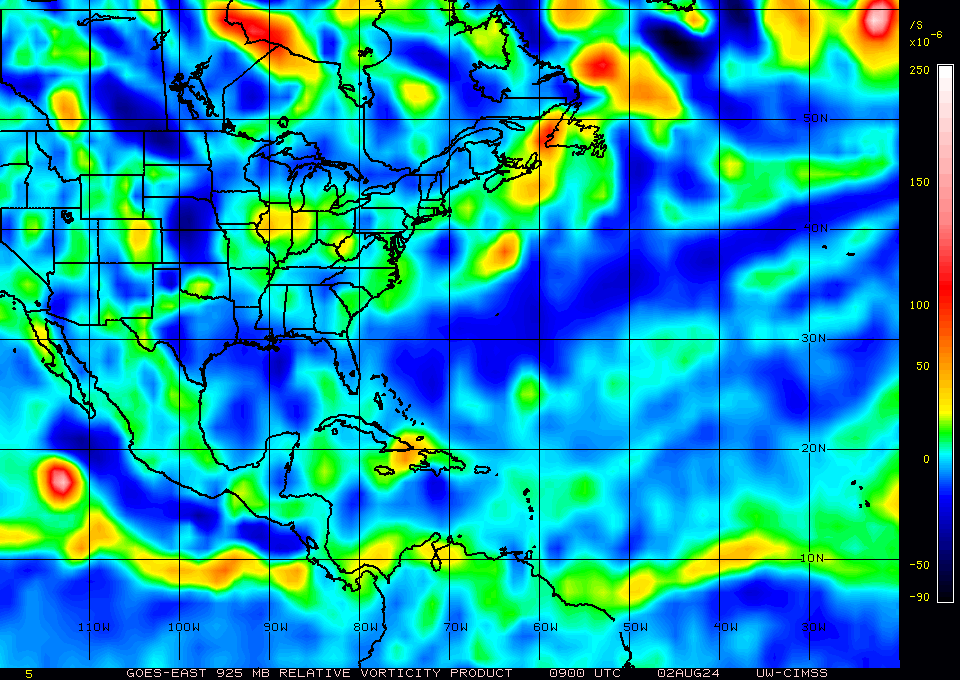
925mb vorticity at 0900z, take the location with a grain of salt 
0 likes
Tropicwatch
Agnes 72', Eloise 75, Elena 85', Kate 85', Charley 86', Florence 88', Beryl 94', Dean 95', Erin 95', Opal 95', Earl 98', Georges 98', Ivan 2004', Arlene 2005', Dennis 2005', Ida 2009' Debby 2012' Irma 2017' Michael 2018'
Agnes 72', Eloise 75, Elena 85', Kate 85', Charley 86', Florence 88', Beryl 94', Dean 95', Erin 95', Opal 95', Earl 98', Georges 98', Ivan 2004', Arlene 2005', Dennis 2005', Ida 2009' Debby 2012' Irma 2017' Michael 2018'

Re: ATL: INVEST 97L - Discussion (50/80)
skillz305 wrote:Anybody got educated guesses about where the “center” or lack of one is at this morning? Models need to know which side of Cuba it’s on!
HWRF and HMON still initializing the surface low near Jamaica so confidence is a little low.
Lots of convection visible in the IR that show an elongated mess with a southern lobe.
Can't see this making it to Tampa in 60 hours if the southern lobe becomes dominant though..
11 AM NHC update should be interesting.
0 likes

Re: ATL: INVEST 97L - Discussion (50/80)
tropicwatch wrote:925mb vorticity at 0900z, take the location with a grain of salt
https://tropicwatch.info/925mb080220240900z.gif
Correct me if I’m wrong, but doesn’t that suggest the initialization of the GFS is maybe too far north?
0 likes
-
USTropics
- Professional-Met

- Posts: 2739
- Joined: Sun Aug 12, 2007 3:45 am
- Location: Florida State University
Re: ATL: INVEST 97L - Discussion (50/80)
N2FSU wrote:tropicwatch wrote:925mb vorticity at 0900z, take the location with a grain of salt
https://tropicwatch.info/925mb080220240900z.gif
Correct me if I’m wrong, but doesn’t that suggest the initialization of the GFS is maybe too far north?
The mid-level circulation is certainly riding the southern coast of Cuba this morning. From Earthnull, here is the 700mb wind flow + RH shaded:

The upper-level vorticity has remained tilted to the south since yesterday morning as well (green circle is mid-level circulation):

5 likes
-
Blown Away

- S2K Supporter

- Posts: 10253
- Joined: Wed May 26, 2004 6:17 am
Re: ATL: INVEST 97L - Discussion (50/80)
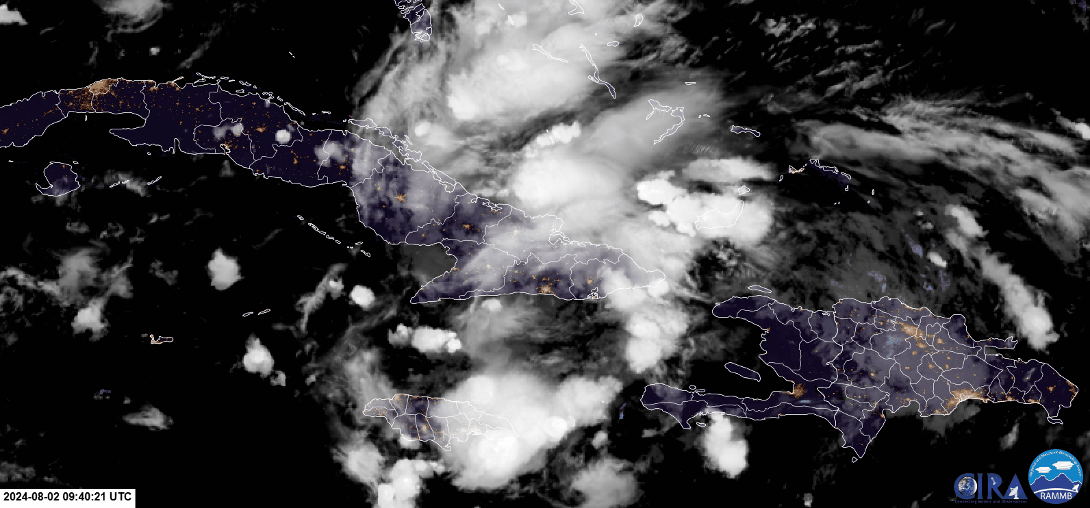
Appears to be some weak low level rotation near the NW tip of Haiti... Very disorganized IMO...
1 likes
Hurricane Eye Experience: David 79, Irene 99, Frances 04, Jeanne 04, Wilma 05… Hurricane Brush Experience: Andrew 92, Erin 95, Floyd 99, Matthew 16, Irma 17, Ian 22, Nicole 22…

Re: ATL: INVEST 97L - Discussion (50/80)
Afternoon popup convection will likely occur along the south shore of Cuba today.
This may relocate the vorts south of where they are forecast to be.
If so, then this may be further west and south once in the GoM.
So, could linger longer and strengthen more than forecast.
A long shot would be that it misses the trof all together.
This may relocate the vorts south of where they are forecast to be.
If so, then this may be further west and south once in the GoM.
So, could linger longer and strengthen more than forecast.
A long shot would be that it misses the trof all together.
1 likes
Re: ATL: INVEST 97L - Discussion (50/80)
Watching area on the north side of Cuba, and what looks like the Mid level stuff off the south side. Interesting setup to see where this goes, Cuba is splitting it at the moment, and keeping it from taking off. If south dominates, most models will be thrown off, if it pulls north, it'll probably more likely for many of the models (especially CMC) to verify.

vis with lightning "ring" to help id the MLC.

vis with lightning "ring" to help id the MLC.
Last edited by BobHarlem on Fri Aug 02, 2024 7:02 am, edited 4 times in total.
0 likes
Re: ATL: INVEST 97L - Discussion (50/80)
GCANE wrote:Afternoon popup convection will likely occur along the south shore of Cuba today.
This may relocate the vorts south of where they are forecast to be.
If so, then this may be further west and south once in the GoM.
So, could linger longer and strengthen more than forecast.
A long shot would be that it misses the trof all together.
I don't know, looking at the low cloud movement it might migrating north toward the heavy convection.
0 likes
-
cycloneye

- Admin

- Posts: 149601
- Age: 69
- Joined: Thu Oct 10, 2002 10:54 am
- Location: San Juan, Puerto Rico
Re: ATL: INVEST 97L - Discussion (60/90)
Tropical Weather Outlook
NWS National Hurricane Center Miami FL
800 AM EDT Fri Aug 2 2024
For the North Atlantic...Caribbean Sea and the Gulf of Mexico:
1. A well-defined tropical wave is producing a large area of poorly
organized showers and thunderstorms over eastern Cuba, Hispaniola,
the southeastern Bahamas, and Jamaica, as well as the adjacent
waters of the southwestern Atlantic and the Caribbean Sea. The wave
is expected to move near or over Cuba throughout the day and then
emerge over the Straits of Florida tonight or Saturday.
Environmental conditions are expected to be conducive for additional
development after that time, and a tropical depression is likely to
form this weekend over the Straits of Florida or eastern Gulf of
Mexico near the Florida Peninsula. Tropical storm watches or
warnings could be required for portions of Florida later today.
Regardless of development, heavy rains could cause areas of flash
flooding across Florida, Cuba, and the Bahamas through the weekend,
and interests in these locations should continue to monitor the
progress of this system. A NOAA Hurricane Hunter aircraft is
scheduled to investigate this system later today.
* Formation chance through 48 hours...medium...60 percent.
* Formation chance through 7 days...high...90 percent.
Forecaster Beven
0 likes
Visit the Caribbean-Central America Weather Thread where you can find at first post web cams,radars
and observations from Caribbean basin members Click Here
and observations from Caribbean basin members Click Here
-
tolakram
- Admin
- Posts: 20186
- Age: 62
- Joined: Sun Aug 27, 2006 8:23 pm
- Location: Florence, KY (name is Mark)
Re: ATL: INVEST 97L - Discussion (60/90)
Floater is over this now
https://weather.cod.edu/satrad/?parms=meso-meso2-02-48-1-100-1&checked=map&colorbar=undefined
https://weather.cod.edu/satrad/?parms=meso-meso2-02-48-1-100-1&checked=map&colorbar=undefined
0 likes
M a r k
- - - - -
Join us in chat: Storm2K Chatroom Invite. Android and IOS apps also available.
The posts in this forum are NOT official forecasts and should not be used as such. Posts are NOT endorsed by any professional institution or STORM2K.org. For official information and forecasts, please refer to NHC and NWS products.

Re: ATL: INVEST 97L - Discussion (60/90)
It certainly seems to my amateur eyes that the system wants to consolidate south of Cuba, and now there's even just as much convection to the south of the island as there is to the north.
0 likes
TC naming lists: retirements and intensity
Most aggressive Advisory #1's in North Atlantic (cr. kevin for starting the list)
Most aggressive Advisory #1's in North Atlantic (cr. kevin for starting the list)
-
cycloneye
- Admin
- Posts: 149601
- Age: 69
- Joined: Thu Oct 10, 2002 10:54 am
- Location: San Juan, Puerto Rico
Re: ATL: INVEST 97L - Discussion (60/90)
Best Track over Cuba.

AL, 97, 2024080212, , BEST, 0, 206N, 756W, 25, 1012, DB
0 likes
Visit the Caribbean-Central America Weather Thread where you can find at first post web cams,radars
and observations from Caribbean basin members Click Here
and observations from Caribbean basin members Click Here

Re: ATL: INVEST 97L - Discussion (60/90)
12z Best track seems like a split the difference position between the MLC on the south and the Convection to the north, I bet this changes for 18z.
Good setup for the the wave equivalent of wobble watching today between that area and the area to the south, to see if the south area pulls up toward there and the circulations align or not.
Good setup for the the wave equivalent of wobble watching today between that area and the area to the south, to see if the south area pulls up toward there and the circulations align or not.
0 likes

Re: ATL: INVEST 97L - Discussion (60/90)
Definitely some turning there. Probably multiple weak vorts within the envelope. Which one, if any, win out.
1 likes

Re: ATL: INVEST 97L - Discussion (60/90)
Looks like this morning’s runs are favoring the scenario where 97L remains weak in the Gulf, crosses Florida, and hangs around the East Coast for a bit. It seems to be exiting the scene a lot faster than yesterday’s runs that showed a similar scenario, which’ll reduce (but obviously not eliminate) the
extent of flooding rains and rip currents around FL/GA/SC.
extent of flooding rains and rip currents around FL/GA/SC.
0 likes
Irene '11 Sandy '12 Hermine '16 5/15/2018 Derecho Fay '20 Isaias '20 Elsa '21 Henri '21 Ida '21
I am only a meteorology enthusiast who knows a decent amount about tropical cyclones. Look to the professional mets, the NHC, or your local weather office for the best information.
I am only a meteorology enthusiast who knows a decent amount about tropical cyclones. Look to the professional mets, the NHC, or your local weather office for the best information.
-
tropicwatch
- Category 5
- Posts: 3426
- Age: 62
- Joined: Sat Jun 02, 2007 10:01 am
- Location: The Villages, Florida
- Contact:
Re: ATL: INVEST 97L - Discussion (60/90)
It appears that the southern circulation is becoming better organized. Out flow to the north is looking good.
1 likes
Tropicwatch
Agnes 72', Eloise 75, Elena 85', Kate 85', Charley 86', Florence 88', Beryl 94', Dean 95', Erin 95', Opal 95', Earl 98', Georges 98', Ivan 2004', Arlene 2005', Dennis 2005', Ida 2009' Debby 2012' Irma 2017' Michael 2018'
Agnes 72', Eloise 75, Elena 85', Kate 85', Charley 86', Florence 88', Beryl 94', Dean 95', Erin 95', Opal 95', Earl 98', Georges 98', Ivan 2004', Arlene 2005', Dennis 2005', Ida 2009' Debby 2012' Irma 2017' Michael 2018'
-
Hypercane_Kyle

- Category 5
- Posts: 3465
- Joined: Sat Mar 07, 2015 7:58 pm
- Location: Cape Canaveral, FL
Re: ATL: INVEST 97L - Discussion (60/90)
Wouldn't be surprised if we start seeing some sort of center developing south of Cuba.
A lot of convection firing off here.

A lot of convection firing off here.
0 likes
My posts are my own personal opinion, defer to the National Hurricane Center (NHC) and other NOAA products for decision making during hurricane season.
-
cycloneye
- Admin
- Posts: 149601
- Age: 69
- Joined: Thu Oct 10, 2002 10:54 am
- Location: San Juan, Puerto Rico
Re: ATL: INVEST 97L - Discussion (60/90)
0 likes
Visit the Caribbean-Central America Weather Thread where you can find at first post web cams,radars
and observations from Caribbean basin members Click Here
and observations from Caribbean basin members Click Here
-
REDHurricane

- Category 1

- Posts: 438
- Age: 28
- Joined: Sun Jul 03, 2022 2:36 pm
- Location: Northeast Pacific Ocean
Re: ATL: INVEST 97L - Discussion (60/90)
Hypercane_Kyle wrote:Wouldn't be surprised if we start seeing some sort of center developing south of Cuba.
A lot of convection firing off here.
https://i.imgur.com/lkQpukC.jpeg
This could be huge since both GEFS and EPS are initializing the system pretty significantly to the north; neither ensemble has any members showing that the current CoC is just off the coast of SE Cuba. I'm guessing that a nasty Gulf storm gets more probable the further to the south it stays and thus the more time it will have to take advantage of the boiling Gulf but who knows anymore with this setup, almost nothing would really surprise me at this point


1 likes
Who is online
Users browsing this forum: No registered users and 1 guest