BobHarlem wrote:What's going on with Recon?
they are passing mouth of MS river in the GOM... heading down.
Moderator: S2k Moderators


BobHarlem wrote:What's going on with Recon?

tolakram wrote:Hurricane warnings issued, and there seems to be a pretty good chance this goes in strengthening unless I'm missing something.000
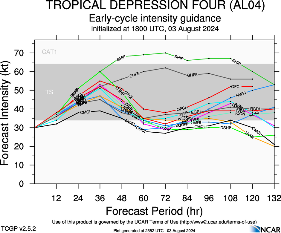
WTNT44 KNHC 032054
TCDAT4
Tropical Storm Debby Discussion Number 6
NWS National Hurricane Center Miami FL AL042024
500 PM EDT Sat Aug 03 2024
The tropical cyclone has become better organized since the last
advisory, with the circulation center becoming better defined over
the southeastern Gulf of Mexico and areas of outer convective
banding to the north and south of the central region. A
combination of earlier scatterometer data, surface observations in
the Florida Keys, and ship reports in the Straits of Florida shows
an area of 30-35 kt winds located about 120 n mi from the center in
the eastern semicircle. Based on this information, Tropical
Depression Four is upgraded to Tropical Storm Debby.
The initial motion is now northwest or 310/13 kt. A large mid- to
upper-level trough over the central United States is creating a
break in the subtropical ridge, and Debby is expected to turn
northward into this break in about 24 h. This should be followed
by a gradual turn toward the northeast at a slower forward speed
through 60 h. This motion should bring the center near or over the
northern Gulf coast in roughly 48 h. After landfall, weakening
steering currents should cause the cyclone to slow down while it
moves northeastward or eastward over parts of northern Florida and
Georgia. The uncertainty in the forecast increases significantly
after 60 h as the cyclone interacts with a portion of the U.S.
trough. The latest GFS and ECMWF models show a slow eastward
motion into the Atlantic, followed by a turn toward the north or
northwest that brings the center back inland. On the other hand,
the Canadian model is still forecasting Debby to move slowly
northeastward across the southeastern states and does not bring it
over the Atlantic. This portion of the new forecast track
continues to show a slow motion and leans toward the GFS/ECMWF
solutions.
Conditions are favorable for strengthening over the Gulf of Mexico
with warm sea surface temperatures and light shear.
Intensification is likely to be slow during the first 12-24 h, then
proceed at a faster rate after the cyclone develops an organized
inner core. The new intensity forecast calls for a peak intensity
of 65 kt at landfall on the Gulf coast of Florida in best agreement
with the HWRF model. Weakening is forecast after landfall while the
system moves over the southeastern United States. Beyond 72 h, the
intensity forecast remains quite uncertain due to the possibility
of land interaction and how much interaction will occur with the
aforementioned mid-latitude trough.
Key Messages:
1. Heavy rainfall will likely result in considerable flash and urban
flooding across portions of Florida and the coastal areas of the
Southeast this weekend through Thursday. Significant river flooding
is also expected.
2. Hurricane conditions are expected on Monday along portions of
the Florida Big Bend region where a Hurricane Warning is in effect,
with tropical storm conditions beginning late Sunday. Tropical storm
conditions are expected through Monday farther south within the
Tropical Storm Warning along Florida's west coast, including the
Tampa Bay area and the Lower Florida Keys.
3. There is a danger of life-threatening storm surge inundation
along portions of the Gulf coast of Florida from Aripeka to Indian
Pass. Life-threatening storm surge is possible south of Aripeka to
Bonita Beach, including Tampa Bay and Charlotte Harbor.
4. Impacts from storm surge, strong winds, and heavy rains are
possible elsewhere in Florida and along the southeast coast of the
United States from Georgia to North Carolina through the middle of
next week, and interests in those areas should continue to monitor
the progress of this system. Additional watches and warnings will
likely be required tonight or on Sunday.
FORECAST POSITIONS AND MAX WINDS
INIT 03/2100Z 23.9N 83.2W 35 KT 40 MPH
12H 04/0600Z 25.3N 84.1W 40 KT 45 MPH
24H 04/1800Z 27.2N 84.6W 45 KT 50 MPH
36H 05/0600Z 28.9N 84.4W 55 KT 65 MPH
48H 05/1800Z 30.2N 83.8W 65 KT 75 MPH...INLAND
60H 06/0600Z 31.0N 83.0W 40 KT 45 MPH...INLAND
72H 06/1800Z 31.3N 82.0W 35 KT 40 MPH...INLAND
96H 07/1800Z 31.5N 80.5W 40 KT 45 MPH...OVER WATER
120H 08/1800Z 33.0N 80.4W 50 KT 60 MPH...INLAND
$$
Forecaster Beven
xironman wrote:Steve wrote:Hurricane2022 wrote:I'm starting to think that we could see an "surprise" major hurricane like Idalia and Michael...
Not Michael. Almost no chance. It would be too far NE in the Gulf for that, too early and MJO is edge of Phase 1. There’s enough support to assume pressure will drop all the way to landfall, but there isn’t anything saying it could get past Cat 2 in the Gulf. JMO, and I do expect it to bring a solid punch. But north of Tampa and east of Apalachicola is really tough to get anything super strong. There’s always a first time as we all know but Big Bend isn’t a hotspot. Record is 3 Cat 3’s ever - 1896 Cedar Key, 1950 Easy and Idalia last year
I understand MJO as far as the ability for tropical systems to develop. But once the core is made it is the up to the surrounding environment as to what it does. Going off of past years has kind of lost its edge. We aren't in Kansas anymore.


Category5Kaiju wrote:https://image.cnbcfm.com/api/v1/image/107124037-16641438332022-09-25t171009z_1990511424_rc2how959k8n_rtrmadp_0_storm-ian.jpeg?v=1664182804&w=929&h=523&vtcrop=y
Btw, this is what Ian looked like 3 days before it hit Ft Myers. Reminscent of Debby given a healthy overall cyclonic "skeleton" was present but there was still not a heck-ton of inner core convection. I'm going to be very interested to see how Debby performs over the bathwater Gulf with 30-32 C waters and nearly 5 knots of shear.

AtlanticWind wrote:If Debby strengthens quicker than forecast (which I am not convinced will happen at this point)
I think it will very likely end up on the east side of the forecast at landfall. Just an opinion


StPeteMike wrote:AtlanticWind wrote:If Debby strengthens quicker than forecast (which I am not convinced will happen at this point)
I think it will very likely end up on the east side of the forecast at landfall. Just an opinion
There’s a lot of variables and outcomes that could happen. A lot of the models have the stall or lack of steering around southeast Georgia, do wonder if that could possibly happen sooner/more around North Florida or NE Gulf.
Zonacane wrote:I don't know why people are prognosticating a weaker storm, this has 2 days, more than enough time.
Users browsing this forum: No registered users and 21 guests


