

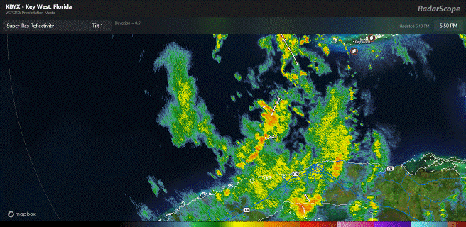
WaveBreaking wrote:I now count 2, maybe 3 VHTs over the center.
With an Anti-Cyclone directly overhead, RI is not out of the question
Moderator: S2k Moderators
WaveBreaking wrote:I now count 2, maybe 3 VHTs over the center.


Steve wrote:Zonacane wrote:I don't know why people are prognosticating a weaker storm, this has 2 days, more than enough time.
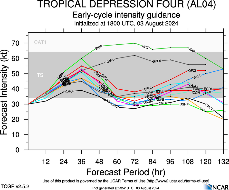
You can just go by what you know. No one has said it’s gonna be weak. But Cat 2 is probably the ceiling if it behaves as most models think. We all know intensity is the hardest and thus far most elusive thing to forecast. But here you go:
https://hurricanes.ral.ucar.edu/realtim ... _early.png
WaveBreaking wrote:I now count 2, maybe 3 VHTs over the center.
Zonacane wrote:Steve wrote:Zonacane wrote:I don't know why people are prognosticating a weaker storm, this has 2 days, more than enough time.
You can just go by what you know. No one has said it’s gonna be weak. But Cat 2 is probably the ceiling if it behaves as most models think. We all know intensity is the hardest and thus far most elusive thing to forecast. But here you go:
https://hurricanes.ral.ucar.edu/realtim ... _early.png
That assumes the minimum definition for RI is met until the storm makes landfall. Given record-breaking SST and a perfect upper-level environment, I fear that would be on the low side.


DunedinDave wrote:It’s amazing just the last 3 years alone how many storms have been coming from western Cuba and targeting anywhere between the Big Bend to Fort Myers.
Elsa, Ian, Idalia, now Debby. Lived here a long time and it used to be one every 5-10 years usually you’d get these tracks. Happening a lot lately. Somehow Tampa dead smack in the middle and always seems to keep dodging the bullet which is crazy.
Steve wrote:Zonacane wrote:Steve wrote:
You can just go by what you know. No one has said it’s gonna be weak. But Cat 2 is probably the ceiling if it behaves as most models think. We all know intensity is the hardest and thus far most elusive thing to forecast. But here you go:
https://hurricanes.ral.ucar.edu/realtim ... _early.png
That assumes the minimum definition for RI is met until the storm makes landfall. Given record-breaking SST and a perfect upper-level environment, I fear that would be on the low side.
We were discussing in the models thread earlier. Lowest I can find is NAM 3km gets it to 983 and NAM 3km has twice (I think Harvey and maybe Idalia) gone sub 900 for comedy sake. So if it’s the lowest pressure you have to correct the bias. That doesn’t mean that if randomly it stalled out or pulled west of 84 and sat over the Gulf it couldn’t get stronger. But if it’s heading into Taylor or Dixie Counties, Cat 3 is the upper limit for anything in recorded weather history. Again we had that last year, 74 years ago in 1950 and 128 years ago with the Cedar Key storm. Most indications are that it’s going to landfall around there. If it’s farther west say Franklin, Gulf or Bay County it’s a different outcome.
caneman wrote:Old girl is ramping. That's clear to see. Florida storms are different.
Hurricane2022 wrote:I think Recon will find 55 kt FL/997 extrap
LandoWill wrote:caneman wrote:Old girl is ramping. That's clear to see. Florida storms are different.
for us here, and you, glad it went west. Florida gulf storms without shear, go crazy - so muggy and hot this time of year
aspen wrote:Hurricane2022 wrote:I think Recon will find 55 kt FL/997 extrap
I doubt it’s that high already. Maybe a 45 kt TS at most. It still needs to consolidate its broad MLC before any significant intensification can start.
Users browsing this forum: No registered users and 36 guests


