https://twitter.com/bmcnoldy/status/1825832771626897724
2024 Indicators: SST's, MSLP, Shear, SAL, Steering, Instability (Day 16+ Climate Models)
Moderator: S2k Moderators
Forum rules

The posts in this forum are NOT official forecasts and should not be used as such. They are just the opinion of the poster and may or may not be backed by sound meteorological data. They are NOT endorsed by any professional institution or STORM2K. For official information, please refer to products from the National Hurricane Center and National Weather Service.
-
toad strangler

- S2K Supporter

- Posts: 4546
- Joined: Sun Jul 28, 2013 3:09 pm
- Location: Earth
- Contact:

Re: 2024 Indicators: SST's, MSLP, Shear, SAL, Steering, Instability (Day 16+ Climate Models)
I'll be willing to go out on a limb with this thought. Watch the mid to long range 500mb model forecasts. For everyone beginning to doubt "the switch flip", keep an eye out for the next significant Westerlies low to drop south into the Eastern CONUS or W. Atlantic. I'd be willing to bet that when that occurs, we'll see the flurry of action begin. Such is often the case.
4 likes
Andy D
(For official information, please refer to the NHC and NWS products.)
(For official information, please refer to the NHC and NWS products.)

-
toad strangler
- S2K Supporter
- Posts: 4546
- Joined: Sun Jul 28, 2013 3:09 pm
- Location: Earth
- Contact:
-
AnnularCane

- S2K Supporter
- Posts: 2957
- Joined: Thu Jun 08, 2006 9:18 am
- Location: Wytheville, VA
Re: 2024 Indicators: SST's, MSLP, Shear, SAL, Steering, Instability (Day 16+ Climate Models)
0 likes
"But it never rained rain. It never snowed snow. And it never blew just wind. It rained things like soup and juice. It snowed mashed potatoes and green peas. And sometimes the wind blew in storms of hamburgers." -- Judi Barrett, Cloudy with a Chance of Meatballs
Re: 2024 Indicators: SST's, MSLP, Shear, SAL, Steering, Instability (Day 16+ Climate Models)
Question. If the OHC is this high, but the surface anomalies are more in the "run-of-the-mill hyperactive year" range of +1C lately (which is still impressive)... Could it be that a few storms are needed to upwell warmer waters that are underneath the surface?
(Kind of similar to how Dennis 2005 traversed through the Eastern Caribbean as a TS/Cat 1, but set the stage for Emily to reach Cat 4 in the same area.)
https://x.com/AndyHazelton/status/1825908101041594661
(Kind of similar to how Dennis 2005 traversed through the Eastern Caribbean as a TS/Cat 1, but set the stage for Emily to reach Cat 4 in the same area.)
https://x.com/AndyHazelton/status/1825908101041594661
0 likes
TC naming lists: retirements and intensity
Most aggressive Advisory #1's in North Atlantic (cr. kevin for starting the list)
Most aggressive Advisory #1's in North Atlantic (cr. kevin for starting the list)
-
Iceresistance

- Category 5

- Posts: 9577
- Age: 22
- Joined: Sat Oct 10, 2020 9:45 am
- Location: Tecumseh, OK/Norman, OK
Re: 2024 Indicators: SST's, MSLP, Shear, SAL, Steering, Instability (Day 16+ Climate Models)
WiscoWx02 wrote:https://www.nhc.noaa.gov/archive/xgtwo/atl/202308191759/two_atl_2d0.png
https://www.nhc.noaa.gov/archive/xgtwo/atl/latest/two_atl_2d0.png
Hmmm....makes you wonder doesn't it? Of course we have Ernesto but if we didn't, talk about being tropically depressed!
I wonder if the North Atlantic is going for a quality vs quantity season
0 likes
Bill 2015 & Beta 2020
Winter 2020-2021
All observations are in Tecumseh, OK unless otherwise noted.
Winter posts are focused mainly for Oklahoma & Texas.
Take any of my forecasts with a grain of salt, refer to the NWS, SPC, and NHC for official information
Never say Never with weather! Because ANYTHING is possible!
Winter 2020-2021
All observations are in Tecumseh, OK unless otherwise noted.
Winter posts are focused mainly for Oklahoma & Texas.
Take any of my forecasts with a grain of salt, refer to the NWS, SPC, and NHC for official information
Never say Never with weather! Because ANYTHING is possible!
-
skyline385

- Category 5
- Posts: 2728
- Age: 35
- Joined: Wed Aug 26, 2020 11:15 pm
- Location: Houston TX
Re: 2024 Indicators: SST's, MSLP, Shear, SAL, Steering, Instability (Day 16+ Climate Models)
New CPC outlook with 60%+ chance of formation in the MDR during August 28 - September 3:
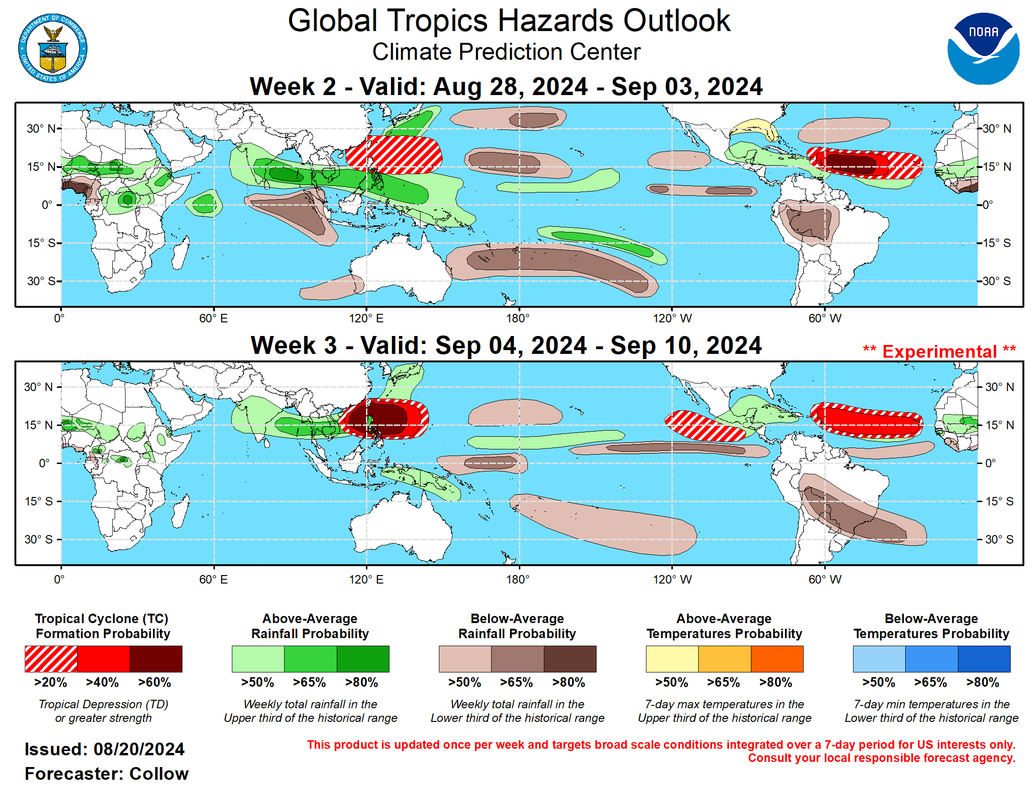
Also, the "experimental" Week 3 products will be transitioned to operational on September 19:
https://x.com/MassachusettsWx/status/1825923911562732011
Also, the "experimental" Week 3 products will be transitioned to operational on September 19:
https://x.com/MassachusettsWx/status/1825923911562732011
3 likes
TC naming lists: retirements and intensity
Most aggressive Advisory #1's in North Atlantic (cr. kevin for starting the list)
Most aggressive Advisory #1's in North Atlantic (cr. kevin for starting the list)
Re: 2024 Indicators: SST's, MSLP, Shear, SAL, Steering, Instability (Day 16+ Climate Models)
Euro weeklies mean ACE forecast update vs norm last 7 days (newest far right, which is 0Z of Tue):
8/26-9/1: 50%/60%/50%/50%/50%/30%/20%; Norm 14
9/2-8: 110%/110%/120%/100%/110%/70%/70%; norm 15
9/9-15: 90%/80%/90%/80%/100%/80%/90%; norm 16
9/16-22: 90%; norm 13
So, in today’s Euro Weeklies update regarding the 3 weeks I’ve been following, yesterday’s progged sharp mean ACE drop from 40 to 28 was maintained today. Also, todays added a new week (9/16-22) with a mean of 12 ACE.
Thus, today’s Euro Weeklies mean ACE prediction for the 4 week period 8/26-9/22 is 40. This 40 compares to the 1991-2020 avg of 58. So, mean ACE prediction is significantly below the 1991-2020 avg mainly due to weeks 1-2 fwiw.
Thoughts?
https://charts.ecmwf.int/products/mofc_ ... 2409020000
1 likes
Personal Forecast Disclaimer:
The posts in this forum are NOT official forecasts and should not be used as such. They are just the opinion of the poster and may or may not be backed by sound meteorological data. They are NOT endorsed by any professional institution or storm2k.org. For official information, please refer to the NHC and NWS products.
The posts in this forum are NOT official forecasts and should not be used as such. They are just the opinion of the poster and may or may not be backed by sound meteorological data. They are NOT endorsed by any professional institution or storm2k.org. For official information, please refer to the NHC and NWS products.


Re: 2024 Indicators: SST's, MSLP, Shear, SAL, Steering, Instability (Day 16+ Climate Models)
Could this be a case of where the Euro "sees" the current unfavorable unseeded conditions and never leaves it? We've seen the Euro miss large scale switches before especially when it has issues with progressing the MJO.LarryWx wrote:Euro weeklies mean ACE forecast update vs norm last 7 days (newest far right, which is 0Z of Tue):
8/26-9/1: 50%/60%/50%/50%/50%/30%/20%; Norm 14
9/2-8: 110%/110%/120%/100%/110%/70%/70%; norm 15
9/9-15: 90%/80%/90%/80%/100%/80%/90%; norm 16
9/16-22: 90%; norm 13
So, in today’s Euro Weeklies update regarding the 3 weeks I’ve been following, yesterday’s progged sharp mean ACE drop from 40 to 28 was maintained today. Also, todays added a new week (9/16-22) with a mean of 12 ACE.
Thus, today’s Euro Weeklies mean ACE prediction for the 4 week period 8/26-9/22 is 40. This 40 compares to the 1991-2020 avg of 58. So, mean ACE prediction is significantly below the 1991-2020 avg mainly due to weeks 1-2 fwiw.
Thoughts?
https://charts.ecmwf.int/products/mofc_ ... 2409020000
I have a hard time believing it at the moment. The West Pacific and East Pacific have been pathetic this year thus far and the current regime doesn't favor that changing. It's very rare for the Atlantic to not be on the other side of the fulcrum being pushed up when those two are down.
4 likes

Re: 2024 Indicators: SST's, MSLP, Shear, SAL, Steering, Instability (Day 16+ Climate Models)
Odds are growing that the Atlantic won’t hit those crazy-high NS forecasts. Once the switch finally flips, it will most likely be a quality-over-quantity season, based on the storms we’ve had so far (5/2/1 and 55 ACE by 8/20, all from tropical waves) and the surprise inhibiting factors we’ve seen. Perhaps 16-19 NS and 150-200 ACE, closer to 2017 than 2019-21 and 2023.
3 likes
Irene '11 Sandy '12 Hermine '16 5/15/2018 Derecho Fay '20 Isaias '20 Elsa '21 Henri '21 Ida '21
I am only a meteorology enthusiast who knows a decent amount about tropical cyclones. Look to the professional mets, the NHC, or your local weather office for the best information.
I am only a meteorology enthusiast who knows a decent amount about tropical cyclones. Look to the professional mets, the NHC, or your local weather office for the best information.
-
storm_in_a_teacup

- Category 1

- Posts: 496
- Age: 33
- Joined: Wed Aug 16, 2017 5:01 pm
- Location: Huntsville, Alabama (originally from Houston)
- Contact:
Re: 2024 Indicators: SST's, MSLP, Shear, SAL, Steering, Instability (Day 16+ Climate Models)
I'm okay with things being quiet. There's so many historical storms to mine for characters and stories 
2 likes
I know I can't straddle the atmosphere...just a tiny storm in your teacup, girl.
-
CyclonicFury

- Category 5
- Posts: 2032
- Age: 27
- Joined: Sun Jul 02, 2017 12:32 pm
- Location: NC
- Contact:
Re: 2024 Indicators: SST's, MSLP, Shear, SAL, Steering, Instability (Day 16+ Climate Models)
Of course I don't like to take long range models at face value, but the CFS has been consistently showing a train of MDR systems starting in the last few days of August through the middle of September. GEFS and EPS have shown significant MDR activity as well, though the Euro weeklies recent run showed slightly below average activity over the next weekend.
I really believe the lack of MDR activity is almost entirely related to the abnormally north monsoon trough position, and that should not be an issue once it retreats southward. Strong easterly shear is a common hinderence in the MDR during August in -ENSO years, especially the far eastern MDR right off Africa.
I really believe the lack of MDR activity is almost entirely related to the abnormally north monsoon trough position, and that should not be an issue once it retreats southward. Strong easterly shear is a common hinderence in the MDR during August in -ENSO years, especially the far eastern MDR right off Africa.
3 likes
NCSU B.S. in Meteorology Class of 2021. Tropical weather blogger at http://www.cyclonicfury.com. My forecasts and thoughts are NOT official, for official forecasts please consult the National Hurricane Center.
-
otowntiger
- Category 5
- Posts: 1932
- Joined: Tue Aug 31, 2004 7:06 pm
Re: 2024 Indicators: SST's, MSLP, Shear, SAL, Steering, Instability (Day 16+ Climate Models)
However hot water is not all it takes to develop hurricanes. Something, or several things seem to successfully working together to suppress activity heading toward the peak of the season despite the very hot SST’s. It’s really pretty amazing. Especially for a season with all the dire warnings of significant and multiple impactful storms.
1 likes
Re: 2024 Indicators: SST's, MSLP, Shear, SAL, Steering, Instability (Day 16+ Climate Models)
otowntiger wrote:
However hot water is not all it takes to develop hurricanes. Something, or several things seem to successfully working together to suppress activity heading toward the peak of the season despite the very hot SST’s. It’s really pretty amazing. Especially for a season with all the dire warnings of significant and multiple impactful storms.
But the bell ring is today. As Dr Phil said, 2/3 of Atlantic hurricanes historically take place between now and October 10. The next 50 days are highly likely to deliver substantial impactful events. What's becoming less likely are the high numbers as we haven't had the junk storms we've become accustomed to. If for some reason the rest of the season is a bust (possible but not likely) the seasonal forecasting crew should just give up!
6 likes
-
WeatherBoy2000
- Category 1
- Posts: 460
- Joined: Mon Apr 10, 2023 9:29 am
Re: 2024 Indicators: SST's, MSLP, Shear, SAL, Steering, Instability (Day 16+ Climate Models)
CyclonicFury wrote:Of course I don't like to take long range models at face value, but the CFS has been consistently showing a train of MDR systems starting in the last few days of August through the middle of September. GEFS and EPS have shown significant MDR activity as well, though the Euro weeklies recent run showed slightly below average activity over the next weekend.
I really believe the lack of MDR activity is almost entirely related to the abnormally north monsoon trough position, and that should not be an issue once it retreats southward. Strong easterly shear is a common hinderence in the MDR during August in -ENSO years, especially the far eastern MDR right off Africa.
2010 was really the last year there have been long tracking CV hurricanes in August. Ever since then we've had to wait until September to get any, even in big years like 2017, it seems like 2024 is continuing that trend. Conditions seem to overall be very favorable, so I think when the switch is flipped it is going to happen in a big way. I also wonder if the CV season will be extended again like it was last year, Tammy formed on the 18th of October.
2 likes
Re: 2024 Indicators: SST's, MSLP, Shear, SAL, Steering, Instability (Day 16+ Climate Models)
CyclonicFury wrote:Of course I don't like to take long range models at face value, but the CFS has been consistently showing a train of MDR systems starting in the last few days of August through the middle of September. GEFS and EPS have shown significant MDR activity as well, though the Euro weeklies recent run showed slightly below average activity over the next weekend.
I really believe the lack of MDR activity is almost entirely related to the abnormally north monsoon trough position, and that should not be an issue once it retreats southward. Strong easterly shear is a common hinderence in the MDR during August in -ENSO years, especially the far eastern MDR right off Africa.
This point intrigued me, so I went ahead and plotted 850-200mb wind shear for all Augusts since 1995.
(All years use August 1-31, except 2024 where I used August 1-18. The climo for both periods are pretty similar, but they use an older period of 1968-96. These are mean shear values, not anomalies, so the climo period doesn't affect the outputs. Also, if anyone wants the static images in an album for easier lookups, I can do that.)
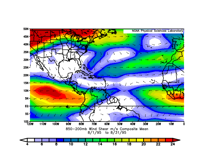
Here are my impressions, but please share your own thoughts since I'm not very well-versed in this topic.
- 2024 has by far the strongest AEJ-induced easterly shear among all these years, and it's also the most extensive, on both north and south ends. No other year comes close.
- By my rough estimate, the other years with strong August AEJs are (stronger to weaker): 2007, 1999, 2012, and a three-way tie of (2011, 2013, 2014). Activities during these years are more of a mixed bag: 1999 had hyperactive ACE, 2011 and 2012 were above average, 2007 largely underperformed expectations, and then there's 2013 lol.
- Note that having strong August AEJs don't necessarily mean a dead August, either. 2012 had a very active August with 8/5/0, and 6 of them formed in the MDR. 2011 also had a 7/2/2 August, with both majors forming in the MDR. 1999 had CV Cat 4 Cindy form on August 19, though it only reached MH on the recurve.
- Also, while they didn't make the top list, 2003, 2008, 2010, 2017 and 1998 all had fairly strong AEJ shear. All but one were hyperactive, and the one that wasn't (2008) was still very impactful.
- Despite CycloneFury's original comment, I can't seem to find a clear correlation between ENSO and Eastern Atlantic shear. For example, the triple Nina 2020-22 actually had pretty low shear in August, similar to 2018-19 which were +ENSO. On the other hand, 2014-15 had pretty strong shear in the region despite being classic Nino years.
- Instead, it almost feels like AEJs (or more specifically, AEJ-induced shear in this region) go through multi-year cycles. 2007-15 had pretty high shear throughout, while 2018-22 had been pretty weak.
Also, one thing that sticks out to me is how low Caribbean shear has been in August 2024. Even the subtropical jet seems anomalously weak. The only seasons with lower Caribbean shear in August were 1995 and 2011; other comparable ones (with slightly higher shear) are 1998, 2005, and arguably 2023 and 2010. All seasons except 2023 had Caribbean hurricanes later, with several majors: Mitch, Wilma, Beta, and Rina (2011). So if the low Caribbean shear persists, combined with record OHC there, it sets up an ominous look for late season even if the MDR season somehow underperforms.
Lastly, 2024's EPAC shear in August looks like a classic La Nina. Years with comparable or stronger shear are 1995, 2010 and 2021. So I wouldn't say the recent EPAC activity means something is off; it's probably an anomaly. This may also suggest La Nina atmosphere is here earlier than the SSTAs indicate.
7 likes
TC naming lists: retirements and intensity
Most aggressive Advisory #1's in North Atlantic (cr. kevin for starting the list)
Most aggressive Advisory #1's in North Atlantic (cr. kevin for starting the list)
-
Category5Kaiju

- Category 5
- Posts: 4330
- Joined: Thu Dec 24, 2020 12:45 pm
- Location: Seattle and Phoenix
Re: 2024 Indicators: SST's, MSLP, Shear, SAL, Steering, Instability (Day 16+ Climate Models)
WeatherBoy2000 wrote:CyclonicFury wrote:Of course I don't like to take long range models at face value, but the CFS has been consistently showing a train of MDR systems starting in the last few days of August through the middle of September. GEFS and EPS have shown significant MDR activity as well, though the Euro weeklies recent run showed slightly below average activity over the next weekend.
I really believe the lack of MDR activity is almost entirely related to the abnormally north monsoon trough position, and that should not be an issue once it retreats southward. Strong easterly shear is a common hinderence in the MDR during August in -ENSO years, especially the far eastern MDR right off Africa.
2010 was really the last year there have been long tracking CV hurricanes in August. Ever since then we've had to wait until September to get any, even in big years like 2017, it seems like 2024 is continuing that trend. Conditions seem to overall be very favorable, so I think when the switch is flipped it is going to happen in a big way. I also wonder if the CV season will be extended again like it was last year, Tammy formed on the 18th of October.
I really do think there’s a general misunderstanding in the wx community regarding how favorable early to mid August is for long-tracked Atlantic hurricanes. There seems to be a natural expectation that a storm like Allen, Andrew, or Charley should happen during a given season, but historically speaking, those are really exceptions and not the norm.
To be fair though, 2024 did feature a record breaking early July Category 5, which threw many off as it was something that only 2005 could do, until this year of course. But each season has its own quirks and is different. As far as I’m aware, our next long-lived Cape Verde hurricane in early to mid August may very well happen in 2025. Or, it may not happen for years.
2 likes
Unless explicitly stated, all info in my posts is based on my own opinions and observations. Tropical storms and hurricanes can be extremely dangerous. Refer to an accredited weather research agency or meteorologist if you need to make serious decisions regarding an approaching storm.
Who is online
Users browsing this forum: mixedDanilo.E and 91 guests