Accepted, s2k wins either way and im good with that.Jr0d wrote:I am willing to bet that by Labor Day weekend(August 31st) that somewhere in the CONUS will be either in an orange potential development cone or in the cone of uncertainty from a classified system.
If I am wrong I will give Storm2k $10...if anyone takes me up on the bet and I am right, they will donate $10...
Any takers?
2024 Global Model Runs Discussion (Out thru day 16)
Moderator: S2k Moderators
Forum rules

The posts in this forum are NOT official forecasts and should not be used as such. They are just the opinion of the poster and may or may not be backed by sound meteorological data. They are NOT endorsed by any professional institution or STORM2K. For official information, please refer to products from the National Hurricane Center and National Weather Service.
-
jlauderdal
- S2K Supporter

- Posts: 7240
- Joined: Wed May 19, 2004 5:46 am
- Location: NE Fort Lauderdale
- Contact:
Re: RE: Re: 2024 Global Model Runs Discussion (Out thru day 16)
3 likes
-
Category5Kaiju

- Category 5

- Posts: 4330
- Joined: Thu Dec 24, 2020 12:45 pm
- Location: Seattle and Phoenix
Re: 2024 Global Model Runs Discussion (Out thru day 16)
Hammy wrote:It's worth pointing out that the CFS has been consistently showing the lid coming off between August 28 and September 2 and shows five storms (at least) developing in the MDR between August 28 and September 15, along with at least one (potentially two) storms in the Gulf of Mexico during that same time--it was also showing a very limited activity for August leading into it.
Iirc the CFS is known to be pretty good with detecting overall favorable/unfavorable conditions as well as the general timeframes of such. We'll see for sure, definitely trust that over the very fickle operational runs as of now if I had to pick.
2 likes
Unless explicitly stated, all info in my posts is based on my own opinions and observations. Tropical storms and hurricanes can be extremely dangerous. Refer to an accredited weather research agency or meteorologist if you need to make serious decisions regarding an approaching storm.

Re: 2024 Global Model Runs Discussion (Out thru day 16)
After posting that I realized I haven't donated in way too long... hopefully there will be more who want to take the bet.
It does look like the Ensembles are heating up for early September so I would be surprised if I am wrong.. time will tell.
If I lose I still win because it means I have no iminent threat besides.
It does look like the Ensembles are heating up for early September so I would be surprised if I am wrong.. time will tell.
If I lose I still win because it means I have no iminent threat besides.
0 likes

Re: 2024 Global Model Runs Discussion (Out thru day 16)
Hammy wrote:It's worth pointing out that the CFS has been consistently showing the lid coming off between August 28 and September 2 and shows five storms (at least) developing in the MDR between August 28 and September 15, along with at least one (potentially two) storms in the Gulf of Mexico during that same time--it was also showing a very limited activity for August leading into it.
Can you post the graphics for said system(s)? I cannot find what you are referring to.
0 likes
-
crownweather

- S2K Supporter
- Posts: 602
- Age: 51
- Joined: Sat Aug 12, 2006 9:21 am
- Location: Sturbridge, Massachusetts
- Contact:
Re: 2024 Global Model Runs Discussion (Out thru day 16)
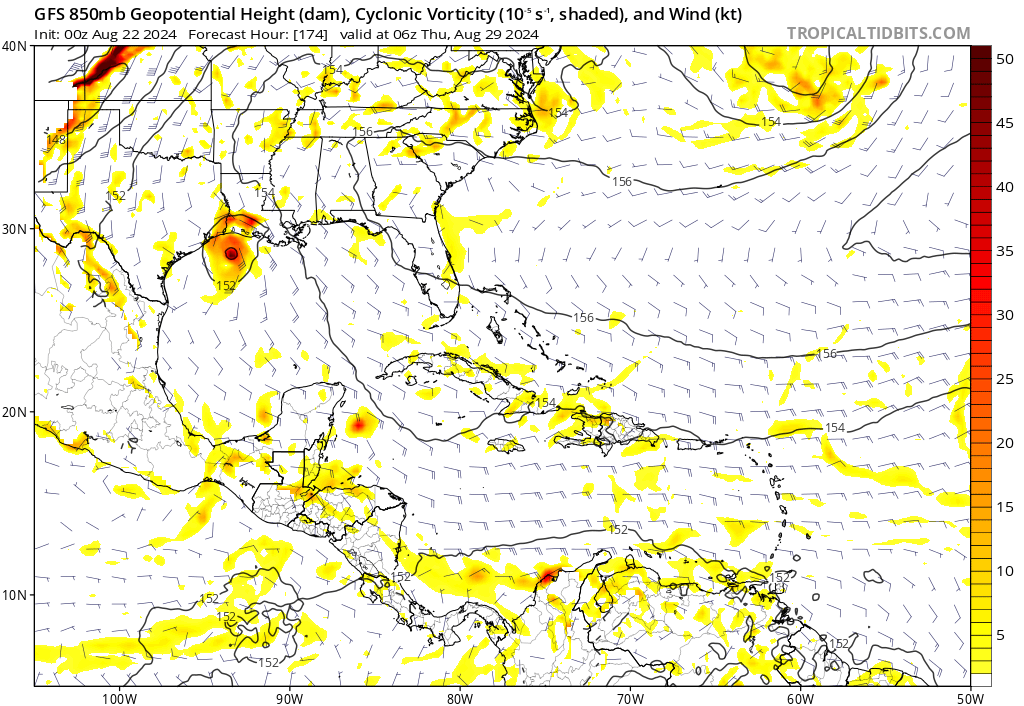
18Z GFS, FWIW, spins up a tropical cyclone in the south central Gulf of Mexico around September 5.
Sent from my iPhone using Tapatalk
Sent from my iPhone using Tapatalk
3 likes
Rob Lightbown
Crown Weather Services
https://crownweather.com
Crown Weather Services
https://crownweather.com
-
Blown Away

- S2K Supporter
- Posts: 10253
- Joined: Wed May 26, 2004 6:17 am
Re: 2024 Global Model Runs Discussion (Out thru day 16)
crownweather wrote:18Z GFS, FWIW, spins up a tropical cyclone in the south central Gulf of Mexico around September 5.
Sent from my iPhone using Tapatalk
For what’s it’s worth, the GFS has consistently shown a big TW/moisture envelope around Labor Day lurking around from GOM/FL/Bahamas… So it wouldn’t surprise me as we close in on time if we see something more significant…
0 likes
Hurricane Eye Experience: David 79, Irene 99, Frances 04, Jeanne 04, Wilma 05… Hurricane Brush Experience: Andrew 92, Erin 95, Floyd 99, Matthew 16, Irma 17, Ian 22, Nicole 22…

-
TomballEd
- Category 5
- Posts: 1262
- Age: 62
- Joined: Wed Aug 16, 2023 4:52 pm
- Location: Spring/Klein area, not Tomball
Re: 2024 Global Model Runs Discussion (Out thru day 16)
Blown Away wrote:crownweather wrote:18Z GFS, FWIW, spins up a tropical cyclone in the south central Gulf of Mexico around September 5.
Sent from my iPhone using Tapatalk
For what’s it’s worth, the GFS has consistently shown a big TW/moisture envelope around Labor Day lurking around from GOM/FL/Bahamas… So it wouldn’t surprise me as we close in on time if we see something more significant…
Several 12Z GFS ensemble members at day 16 are seeing lows in the Gulf. Some GEPS support as well. Even some EPS support. I'll be watching it, but I'll also be seeing it if it stays at the very end of the operation and ensemble model runs. But the big 3 ensembles sort of liking it, going to be interesting.
0 likes
-
Frank P
- S2K Supporter
- Posts: 2779
- Joined: Fri Aug 29, 2003 10:52 am
- Location: Biloxi Beach, Ms
- Contact:
Re: 2024 Global Model Runs Discussion (Out thru day 16)
The season is not cancelled, it is only delayed a few weeks. It's also possible that the season will extend well into November especially for the FL and Caribbean Islands, no one can accurately predict what will happen... I will assume the season will pick up and be active until such time it is not... but by no means is this season cancelled... FYI I have a personal weather station linked to the Wunderground system... here is the link
https://www.wunderground.com/dashboard/pws/KMSBILOX136
I'm trying to get one of my 13 outdoor cameras linked as well so you can see images of the beach in Biloxi during storm events
The weather station will come in handy if you want to see wind and BP on the beach in Biloxi in the event we were to be threatened by a storm this season
5 likes
-
Stratton23
- Category 5
- Posts: 3517
- Joined: Fri Jul 21, 2023 10:59 pm
- Location: Katy, Tx
Re: 2024 Global Model Runs Discussion (Out thru day 16)
18z GEFS has a much stronger signal for gulf activity in the first week of September
0 likes
-
Stratton23
- Category 5
- Posts: 3517
- Joined: Fri Jul 21, 2023 10:59 pm
- Location: Katy, Tx
Re: 2024 Global Model Runs Discussion (Out thru day 16)
The 00z CMC attempts to close off the gulf upper low and tries to develop a weak surface center/ low just before making landfall in texas at hour 78, ive been saying this could be a very tricky situation in which its possible we see a quick spin up into a very weak short lived TD, this is something models can have trouble catching. on to
0 likes
-
Stratton23
- Category 5
- Posts: 3517
- Joined: Fri Jul 21, 2023 10:59 pm
- Location: Katy, Tx
Re: 2024 Global Model Runs Discussion (Out thru day 16)
Tropical trouble in the gulf next week? Now the 00z GFS is getting really interesting
0 likes
Re: 2024 Global Model Runs Discussion (Out thru day 16)
Hmm...
1 likes
TC naming lists: retirements and intensity
Most aggressive Advisory #1's in North Atlantic (cr. kevin for starting the list)
Most aggressive Advisory #1's in North Atlantic (cr. kevin for starting the list)
-
DorkyMcDorkface

- Category 4

- Posts: 984
- Age: 28
- Joined: Mon Sep 30, 2019 1:32 pm
- Location: Mid-Atlantic
Re: 2024 Global Model Runs Discussion (Out thru day 16)
Finally some signs of life as the 00z CMC spins up a system from the monsoon trough breaking down, and also has a tropical wave moving off the African coast towards the end of the run. Worth seeing if this is the start of something, especially within the rest of the guidance.
6 likes
Please note the thougths expressed by this account are solely those of the user and are from a hobbyist perspective. For more comprehensive analysis, consult an actual professional meteorologist or meteorology agency.
Floyd 1999 | Isabel 2003 | Hanna 2008 | Irene 2011 | Sandy 2012 | Isaias 2020
-
MarioProtVI
- Category 5
- Posts: 1034
- Age: 24
- Joined: Sun Sep 29, 2019 7:33 pm
- Location: New Jersey
Re: 2024 Global Model Runs Discussion (Out thru day 16)
DorkyMcDorkface wrote:Finally some signs of life as the 00z CMC spins up a system from the monsoon trough breaking down, and also has a tropical wave moving off the African coast towards the end of the run. Worth seeing if this is the start of something, especially within the rest of the guidance.
https://uploads.disquscdn.com/images/8ea78cf1beaefb049b8b358284875afba88efa886408736d327ed2d1b7e66e0e.gif
Euro-AI and ICON have this feature around the same timeframe so maybe this is legit. Need to see consistency though instead of it dropping it the next run at 12z.
2 likes

Re: 2024 Global Model Runs Discussion (Out thru day 16)
DorkyMcDorkface wrote:Finally some signs of life as the 00z CMC spins up a system from the monsoon trough breaking down, and also has a tropical wave moving off the African coast towards the end of the run. Worth seeing if this is the start of something, especially within the rest of the guidance.
https://uploads.disquscdn.com/images/8ea78cf1beaefb049b8b358284875afba88efa886408736d327ed2d1b7e66e0e.gif
It's definitely worth noting the Canadian was the first one to sniff out Beryl, which also formed from the monsoonal breakdown
3 likes
The above post is not official and should not be used as such. It is the opinion of the poster and may or may not be backed by sound meteorological data. It is not endorsed by any professional institution or storm2k.org. For official information, please refer to the NHC and NWS products.
-
emeraldislenc
- Category 2

- Posts: 601
- Joined: Fri Aug 24, 2012 4:49 pm
- Location: Emerald Isle NC
Re: 2024 Global Model Runs Discussion (Out thru day 16)
I hope we can all get back to global model discussions and leave our egos to another platform!
4 likes
-
Weathertracker96
- Tropical Storm

- Posts: 150
- Joined: Mon Oct 16, 2023 3:41 pm
Re: 2024 Global Model Runs Discussion (Out thru day 16)
06GFS is showing activity this morning in Gulf & Caribbean
1 likes
-
TomballEd
- Category 5
- Posts: 1262
- Age: 62
- Joined: Wed Aug 16, 2023 4:52 pm
- Location: Spring/Klein area, not Tomball
Re: 2024 Global Model Runs Discussion (Out thru day 16)
The 0Z/6Z GFS system next week on the model is being badly sheared with dry air being pushed into the low and will struggle to be below 1010 mb. A slight repositioning of the entire jet pattern would mean lower shear and a system that might strengthen over 30C water.
6Z ensembles have some members supporting the op, although none are very strong, GEPS has a 1011 and 1014 mb low as well. As modeled not making much rain IMBY, been upper 90s and low 100s since Beryl and little rain, a weak rainmaker would be perfect.
6Z ensembles have some members supporting the op, although none are very strong, GEPS has a 1011 and 1014 mb low as well. As modeled not making much rain IMBY, been upper 90s and low 100s since Beryl and little rain, a weak rainmaker would be perfect.
0 likes
-
xtyphooncyclonex

- Category 5
- Posts: 3890
- Age: 24
- Joined: Sat Dec 08, 2012 9:07 am
- Location: Cebu City
- Contact:
Re: 2024 Global Model Runs Discussion (Out thru day 16)
Season cancelled: cancelled 

6 likes
REMINDER: My opinions that I, or any other NON Pro-Met in this forum, are unofficial. Please do not take my opinions as an official forecast and warning. I am NOT a meteorologist. Following my forecasts blindly may lead to false alarm, danger and risk if official forecasts from agencies are ignored.
Who is online
Users browsing this forum: No registered users and 71 guests