
2024 Global Model Runs Discussion (Out thru day 16)
Moderator: S2k Moderators
Forum rules

The posts in this forum are NOT official forecasts and should not be used as such. They are just the opinion of the poster and may or may not be backed by sound meteorological data. They are NOT endorsed by any professional institution or STORM2K. For official information, please refer to products from the National Hurricane Center and National Weather Service.
Re: 2024 Global Model Runs Discussion (Out thru day 16)
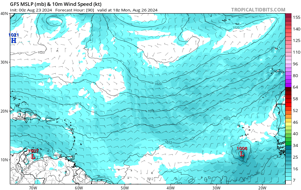
0z GFS (operational) shows a 1006 mb TS in the far eastern MDR at 90 hrs, that moves NNE (lol) and dissipates quickly. The 3 prior runs all seem to show a closed low, with the system getting better organized each run. The ceiling still seems quite low, though.
0 likes
TC naming lists: retirements and intensity
Most aggressive Advisory #1's in North Atlantic (cr. kevin for starting the list)
Most aggressive Advisory #1's in North Atlantic (cr. kevin for starting the list)
-
Stratton23
- Category 5

- Posts: 3518
- Joined: Fri Jul 21, 2023 10:59 pm
- Location: Katy, Tx
Re: 2024 Global Model Runs Discussion (Out thru day 16)
Until we get any sort of consistency in the operational models, ensemble guidance is the way to go, the OP modes are very clearly struggling given how each run is dramatically different, it can be frustrating sometimes because in the weather world, we want consistency in the models, but we dont always get that
0 likes
-
MarioProtVI
- Category 5
- Posts: 1034
- Age: 24
- Joined: Sun Sep 29, 2019 7:33 pm
- Location: New Jersey
Re: 2024 Global Model Runs Discussion (Out thru day 16)
Aaaand the 00z GEFS downticked again at 240h.
0 likes
-
Stratton23
- Category 5
- Posts: 3518
- Joined: Fri Jul 21, 2023 10:59 pm
- Location: Katy, Tx
Re: 2024 Global Model Runs Discussion (Out thru day 16)
And their appears to be no consistency in the ensembles what so ever either, very annoying
0 likes

Re: 2024 Global Model Runs Discussion (Out thru day 16)
Increasingly feels like the models are struggling to resolve the monsoon trough breakdown and where it's going to happen. Every time we see this sort of inconsistency/vacancy in the models, always seems to coincide with that. When we have separate, spaced out disturbances, they seem more able to zero in on development farther out.
3 likes
The above post is not official and should not be used as such. It is the opinion of the poster and may or may not be backed by sound meteorological data. It is not endorsed by any professional institution or storm2k.org. For official information, please refer to the NHC and NWS products.
-
Stratton23
- Category 5
- Posts: 3518
- Joined: Fri Jul 21, 2023 10:59 pm
- Location: Katy, Tx
Re: 2024 Global Model Runs Discussion (Out thru day 16)
I see talk about the monsoon trough, but what actually is the monsoon trough? Ive personally never heard of that feature, but clearly it does seem like its giving the op models and ensembles a fit right now
0 likes
Re: 2024 Global Model Runs Discussion (Out thru day 16)
Stratton23 wrote:I see talk about the monsoon trough, but what actually is the monsoon trough? Ive personally never heard of that feature, but clearly it does seem like its giving the op models and ensembles a fit right now
Essentially the monsoon trough is a large low pressure trough along the ITCZ during summer, featuring a strong, low level westerly/southwesterly flow to the south. (In the northern hemisphere, it's most common in Africa, Central America (and extending into the east pacific), and the Indian Ocean/western Pacific (it's the same feature that induces Central American gyres in the Caribbean that can spark storm development there or in the eastern Pacific).
The unique problem (if you're looking for development at least) in the Atlantic is, it's centered over desert--so unlike in the Pacific, when you get these large sprawling monsoon depressions over water, the Atlantic instead gets these broad, diffuse dry air laden systems stringing out over the eastern basin. So, if this is too strong, and too far north, it tends to bring a lot of dry air and dust over the basin--and because of it's strength, things are strung out (and sometimes reabsorbed) before they can develop further west.
6 likes
The above post is not official and should not be used as such. It is the opinion of the poster and may or may not be backed by sound meteorological data. It is not endorsed by any professional institution or storm2k.org. For official information, please refer to the NHC and NWS products.
Re: 2024 Global Model Runs Discussion (Out thru day 16)
Hammy wrote:Something worth noting, the Euro is a good model to watch for when the switch flips--every prior season that I've followed the models, leading up to the switch, it would start trying to develop tropical storms over Africa before gradually moving up the timeline (and moving them over water)

There it is, the Euro's land-depression.
Another look showing the monsoon trough finally breaking down, with the monsoon to the north and ITCZ to the south. The Euro has typically had a north-bias to these tracks once it starts happening so there's a fair chance we'll start getting tropical storms out of these over the next several runs


10 likes
The above post is not official and should not be used as such. It is the opinion of the poster and may or may not be backed by sound meteorological data. It is not endorsed by any professional institution or storm2k.org. For official information, please refer to the NHC and NWS products.

Re: 2024 Global Model Runs Discussion (Out thru day 16)
floridasun wrote:people think season is cancel but not case we seen before that wont see system week or so in already and sep we see flood gate open maybe last week aug too if dont see system that good we already have few hurr cause issues in islands Caribbean and bermuda and texas
Need Florida sun to see Texas its only 7.
0 likes
Re: 2024 Global Model Runs Discussion (Out thru day 16)
The 6Z Euro-AIFS has a TC that originates from a TCG in the vicinity of the Leeward Islands ~Sept 2nd. This makes it the 17th run in a row with a TCG near the Leewards ~9/2. This goes all of the way back to the 6Z 8/19 run! You can still see all of these runs on Tropical Tidbits.
1 likes
Personal Forecast Disclaimer:
The posts in this forum are NOT official forecasts and should not be used as such. They are just the opinion of the poster and may or may not be backed by sound meteorological data. They are NOT endorsed by any professional institution or storm2k.org. For official information, please refer to the NHC and NWS products.
The posts in this forum are NOT official forecasts and should not be used as such. They are just the opinion of the poster and may or may not be backed by sound meteorological data. They are NOT endorsed by any professional institution or storm2k.org. For official information, please refer to the NHC and NWS products.
-
jlauderdal
- S2K Supporter

- Posts: 7240
- Joined: Wed May 19, 2004 5:46 am
- Location: NE Fort Lauderdale
- Contact:
Re: RE: Re: 2024 Global Model Runs Discussion (Out thru day 16)
Oct is most active for the sunshine state....Wilma Sofla was our big storm, late Oct.LarryWx wrote:I believe that Oct is the most dangerous month for the Gulf coast of FL. And we still have Sep before that. Believe me when I say I’d love for those months to be quiet. But I’m not betting on it.
0 likes
-
WaveBreaking

- Category 2

- Posts: 717
- Joined: Sun Jun 30, 2024 11:33 am
- Location: US
Re: 2024 Global Model Runs Discussion (Out thru day 16)
06z GEFS

Last edited by WaveBreaking on Fri Aug 23, 2024 10:59 am, edited 1 time in total.
2 likes
I am NOT a professional meteorologist, so take all of my posts with a grain of salt. My opinions are mine and mine alone.
-
MarioProtVI
- Category 5
- Posts: 1034
- Age: 24
- Joined: Sun Sep 29, 2019 7:33 pm
- Location: New Jersey
-
WaveBreaking
- Category 2
- Posts: 717
- Joined: Sun Jun 30, 2024 11:33 am
- Location: US
Re: 2024 Global Model Runs Discussion (Out thru day 16)
MarioProtVI wrote:
That’s yesterdays’s run.
Corrected it.
3 likes
I am NOT a professional meteorologist, so take all of my posts with a grain of salt. My opinions are mine and mine alone.
Re: 2024 Global Model Runs Discussion (Out thru day 16)
12z ICON shows development in the central MDR at 180 hours. It also shows a TS inland Africa, that got down to 995 mb before weakening to 1000 on this frame.
(Edited to say 12z, not 0z)
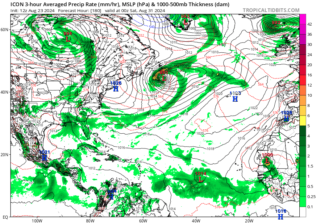
(Edited to say 12z, not 0z)
Last edited by Teban54 on Fri Aug 23, 2024 1:02 pm, edited 1 time in total.
0 likes
TC naming lists: retirements and intensity
Most aggressive Advisory #1's in North Atlantic (cr. kevin for starting the list)
Most aggressive Advisory #1's in North Atlantic (cr. kevin for starting the list)
Re: 2024 Global Model Runs Discussion (Out thru day 16)
Teban54 wrote:0z ICON shows development in the central MDR at 180 hours. It also shows a TS inland Africa, that got down to 995 mb before weakening to 1000 on this frame.
https://i.postimg.cc/pdbqrRjT/image.png
This appears to be consistent with the timing on all of those AI-Euro runs with TCG near Sept 2nd around the NE Caribbean.
Last edited by LarryWx on Fri Aug 23, 2024 12:53 pm, edited 1 time in total.
0 likes
Personal Forecast Disclaimer:
The posts in this forum are NOT official forecasts and should not be used as such. They are just the opinion of the poster and may or may not be backed by sound meteorological data. They are NOT endorsed by any professional institution or storm2k.org. For official information, please refer to the NHC and NWS products.
The posts in this forum are NOT official forecasts and should not be used as such. They are just the opinion of the poster and may or may not be backed by sound meteorological data. They are NOT endorsed by any professional institution or storm2k.org. For official information, please refer to the NHC and NWS products.
Re: 2024 Global Model Runs Discussion (Out thru day 16)
12z CMC continues to show genesis in the MDR on Day 7. The end of the run is the strongest so far at 997 mb (CMC often underestimates intensity). This makes it 4 runs (2 days) of consistent development on the model, and the 2 runs before that also had some hints.
2 likes
TC naming lists: retirements and intensity
Most aggressive Advisory #1's in North Atlantic (cr. kevin for starting the list)
Most aggressive Advisory #1's in North Atlantic (cr. kevin for starting the list)
-
Stratton23
- Category 5
- Posts: 3518
- Joined: Fri Jul 21, 2023 10:59 pm
- Location: Katy, Tx
Re: 2024 Global Model Runs Discussion (Out thru day 16)
And of course the GFS shows nothing again, shocker!
0 likes
-
TallyTracker
- Category 2
- Posts: 787
- Joined: Thu Oct 11, 2018 2:46 pm
Re: 2024 Global Model Runs Discussion (Out thru day 16)
The models are showing about as many TSs over Africa as over the Atlantic. That’s how unfavorable the Atlantic is right now. lol I was thinking we’d get a couple of more named storms in August, but I’m gonna be surprised if we get one more now with all that stability.
2 likes
Fran '96, Georges '98, Gordon '00, Gabrielle '01, Charley '04, Frances '04, Jeanne '04, Barry '07, Fay '08, Debby '12, Matthew '16, Emily '17, Irma '17, Michael ‘18, Elsa ‘21, Fred ‘21, Mindy ‘21, Nicole ‘22, Idalia ‘23, Debby ‘24, Helene ‘24
-
Stratton23
- Category 5
- Posts: 3518
- Joined: Fri Jul 21, 2023 10:59 pm
- Location: Katy, Tx
Re: 2024 Global Model Runs Discussion (Out thru day 16)
And just like that the 12z GEFS at day 10 once again upticked , what a roller coaster lol
1 likes
Who is online
Users browsing this forum: gib, Google [Bot] and 105 guests