

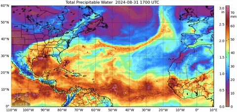
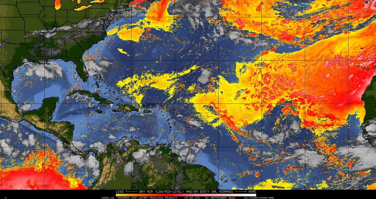
It's pretty clear now that the ITCZ shenanigans over Africa were underestimated in their significance. They pretty much robbed the basin of vorticity, now we're just left with these anemic dried out waves.


Moderator: S2k Moderators

Woofde wrote:The tropical waves this past month have just been pathetic. As a comparison I found a shot from Late June. Even if you ignore Beryl the other two areas are more bundled together and healthier.
It's pretty clear now that the ITCZ shenanigans over Africa were underestimated in their significance. They pretty much robbed the basin of vorticity, now we're just left with these anemic dried out waves.https://uploads.tapatalk-cdn.com/20240901/aa58f408f2b764be292469c0ba36dd6c.jpg https://uploads.tapatalk-cdn.com/20240901/4128518ec5c4d3c3782bfb76cdeb1aac.jpg


WaveBreaking wrote:IMO, this season might pull off a repeat of 2022’s lull period, except the lull will be delayed by a few weeks.
The current SST configuration resembles that of 2022 during the same time period, complete with the (shifted east) high-latitude warm blob and the relatively cool tongue of waters near the African coast. It seems that this year, however, the dry air problems are more to the east near the African coast, which has worked in tandem with the hyperactive African Monsoon to starve any waves of convection and/or concentrated vorticity.
https://i.imgur.com/AZmEpyZ.gif
One thing that also caught my eye is how 2024’s SST configuration changed from something resembling 2005’s in July to something closer to 2022’s configuration in late August/Early September. The warm blob also shifted to the SE during this timeframe, which is probably why dry air wasn’t so much of an issue in early August compared to now.
https://i.imgur.com/LkqjiKZ.gif
If we assume that this year does in fact follow 2022’s progression from now on, then we still shouldn’t let our guard down (i.e., Fiona and Ian). The key differences this year (1st-year cool neutral instead of 3rd-year moderate La Niña; any possible effects from the Hunga-Tonga eruption being less prominent due to the stratosphere recovering from the influx of water vapor) might mean that once the now-delayed switch does flip, then the spike in activity like we saw in September 2022 will likely last just as long or even long than 2022’s.
MarioProtVI wrote: https://x.com/webberweather/status/1830280739969261942
As I thought, something changed dramatically in late July that resulted in the unfavorable pattern across the basin and is smothering any TCG.
MarioProtVI wrote: https://x.com/webberweather/status/1830280739969261942
As I thought, something changed dramatically in late July that resulted in the unfavorable pattern across the basin and is smothering any TCG.

NDG wrote:https://x.com/ndgmetchef/status/1830324989435773209?s=46
Teban54 wrote:
I don't know anyone that thought Debby had struggled. The highest peak NHC had ever forecast for it was 80 kt, which is still a Cat 1, and within the margin of error compared to the actual peak (70 kt). Anyone who seriously expected it to become a major was probably just -removed-.
aspen wrote:Teban54 wrote:NDG wrote:https://x.com/ndgmetchef/status/1830324989435773209?s=46
I don't know anyone that thought Debby had struggled. The highest peak NHC had ever forecast for it was 80 kt, which is still a Cat 1, and within the margin of error compared to the actual peak (70 kt). Anyone who seriously expected it to become a major was probably just -removed-.
Debby simply didn’t have enough time despite being over SSTs close to 32C. Perhaps there was an outside chance of it going bananas if the core managed to put itself together quickly.
Ernesto should be the one people point towards as an under-achiever. Forecast to become a MH, but due a combination of its broad circulation and nearby dry air, it constantly struggled until that last bit of intensification over the northernmost Gulf Stream (which was probably higher than its operational peak).
I compared Ernesto to Earl ‘22 even early on in its life, and seeing how this season is a comparable under-performer to 2022, those comparisons are becoming more justified.
aspen wrote:Teban54 wrote:
I don't know anyone that thought Debby had struggled. The highest peak NHC had ever forecast for it was 80 kt, which is still a Cat 1, and within the margin of error compared to the actual peak (70 kt). Anyone who seriously expected it to become a major was probably just -removed-.
Debby simply didn’t have enough time despite being over SSTs close to 32C. Perhaps there was an outside chance of it going bananas if the core managed to put itself together quickly.
Ernesto should be the one people point towards as an under-achiever. Forecast to become a MH, but due a combination of its broad circulation and nearby dry air, it constantly struggled until that last bit of intensification over the northernmost Gulf Stream (which was probably higher than its operational peak).
I compared Ernesto to Earl ‘22 even early on in its life, and seeing how this season is a comparable under-performer to 2022, those comparisons are becoming more justified.
Ubuntwo wrote:aspen wrote:Teban54 wrote:I don't know anyone that thought Debby had struggled. The highest peak NHC had ever forecast for it was 80 kt, which is still a Cat 1, and within the margin of error compared to the actual peak (70 kt). Anyone who seriously expected it to become a major was probably just -removed-.
Debby simply didn’t have enough time despite being over SSTs close to 32C. Perhaps there was an outside chance of it going bananas if the core managed to put itself together quickly.
Ernesto should be the one people point towards as an under-achiever. Forecast to become a MH, but due a combination of its broad circulation and nearby dry air, it constantly struggled until that last bit of intensification over the northernmost Gulf Stream (which was probably higher than its operational peak).
I compared Ernesto to Earl ‘22 even early on in its life, and seeing how this season is a comparable under-performer to 2022, those comparisons are becoming more justified.
The dry air Ernesto was dealing with was being sucked in from quite a distance. A compact storm wouldn't have had that issue - its problems were really structural. You could argue the broad nature of the disturbance Ernesto originated from was an indicator, maybe? Then again, 2020 had the exceptionally broad pre-Isaias.
Teban54 wrote:
I don't know anyone that thought Debby had struggled. The highest peak NHC had ever forecast for it was 80 kt, which is still a Cat 1, and within the margin of error compared to the actual peak (70 kt). Anyone who seriously expected it to become a major was probably just -removed-.
Debby will continue to move over waters of high heat content
and remain in an environment of low vertical wind shear into Monday
morning. Some dry air intrusion over the southwestern portion of
the circulation may have temporarily interrupted the intensification
process. However, given the favorable oceanic and shear
conditions, significant strengthening is expected before landfall.
Rapid intensification is especially likely if Debby acquires a
well-defined inner core.
NDG wrote:Teban54 wrote:NDG wrote:https://x.com/ndgmetchef/status/1830324989435773209?s=46
I don't know anyone that thought Debby had struggled. The highest peak NHC had ever forecast for it was 80 kt, which is still a Cat 1, and within the margin of error compared to the actual peak (70 kt). Anyone who seriously expected it to become a major was probably just -removed-.
Debby struggled over the GOM for a whole 24 hrs to try to get a core going but dry air intrusion kept it at bay. Debby making landfall a whole 10 knots below the forecasted 80 knots by the usual conservative NHC says a lot.
The significant strengthening & rapid intensification never happened:Debby will continue to move over waters of high heat content
and remain in an environment of low vertical wind shear into Monday
morning. Some dry air intrusion over the southwestern portion of
the circulation may have temporarily interrupted the intensification
process. However, given the favorable oceanic and shear
conditions, significant strengthening is expected before landfall.
Rapid intensification is especially likely if Debby acquires a
well-defined inner core.
Users browsing this forum: gib and 147 guests


