2024 Global Model Runs Discussion (Out thru day 16)

This is the general tropical discussion area. Anyone can take their shot at predicting a storms path.

Moderator: S2k Moderators

Forum rules

The posts in this forum are NOT official forecasts and should not be used as such. They are just the opinion of the poster and may or may not be backed by sound meteorological data. They are NOT endorsed by any professional institution or STORM2K. For official information, please refer to products from the National Hurricane Center and National Weather Service.

Help Support Storm2K
Message
Author
User avatar
Teban54
Category 5
Category 5
Posts: 3204
Joined: Sat May 19, 2018 1:19 pm

Re: 2024 Global Model Runs Discussion (Out thru day 16)

#1741 Postby Teban54 » Fri Sep 06, 2024 8:28 am

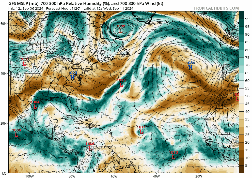
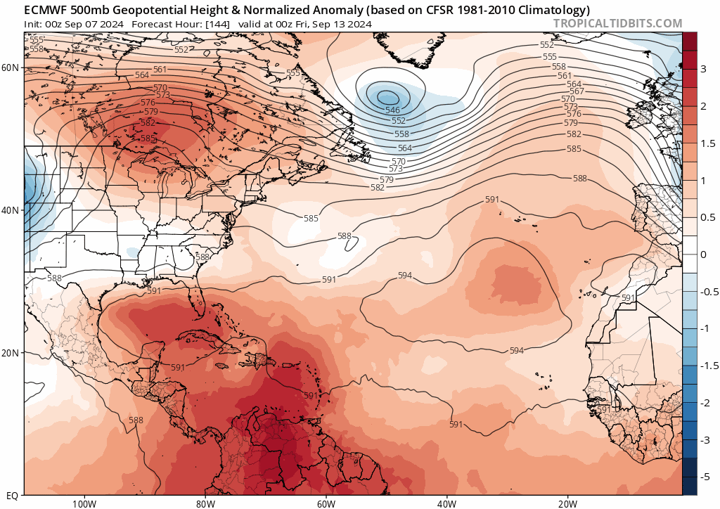
MetroMike wrote:It’s rather odd the NHC gave the lemon only 0% to10% this morning in the east Atlantic. Discounting the GFS ideas as bogus maybe.

That's a different system. The 0/10 is the monsoon trough disturbance that's currently in Eastern Atlantic that had been on the TWO for days, and most models don't do much with it (except 6z GFS). The CV long-tracker that has been on many recent GFS runs comes from a wave that will exit Africa around September 10, which has not been introduced to the TWO yet.
2 likes   

MEANINGLESS_NUMBERS
Category 1
Category 1
Posts: 329
Joined: Mon Nov 02, 2020 1:43 pm

Re: 2024 Global Model Runs Discussion (Out thru day 16)

#1742 Postby MEANINGLESS_NUMBERS » Fri Sep 06, 2024 8:38 am

06Z GFS has two hurricanes hitting Bermuda on Sept 19 (989 mbar) and then Sept 21 (958 mbar), almost exactly 10 years since Hurricanes Fay and Gonzalo made landfall in the same week. Spooky.
0 likes   
Emily '87, Felix '95, Gert '99, Fabian '03, Humberto '19, Paulette '20, Teddy '20, Fiona '22, Lee '23, Ernesto '24

MarioProtVI
Category 4
Category 4
Posts: 935
Age: 24
Joined: Sun Sep 29, 2019 7:33 pm
Location: New Jersey

Re: 2024 Global Model Runs Discussion (Out thru day 16)

#1743 Postby MarioProtVI » Fri Sep 06, 2024 11:33 am

12z GFS and CMC both dropped the Tuesday wave in line with the Euro. Go figure with how hostile this season has been :roll:
1 likes   

Pelicane
Tropical Storm
Tropical Storm
Posts: 100
Joined: Tue Sep 13, 2022 1:52 pm
Location: Lafayette, Louisiana

Re: 2024 Global Model Runs Discussion (Out thru day 16)

#1744 Postby Pelicane » Fri Sep 06, 2024 11:34 am

GFS drops the MDR long-tracker completely. Still quiet as can be in the deep tropics.
0 likes   

User avatar
gatorcane
S2K Supporter
S2K Supporter
Posts: 23691
Age: 47
Joined: Sun Mar 13, 2005 3:54 pm
Location: Boca Raton, FL

Re: 2024 Global Model Runs Discussion (Out thru day 16)

#1745 Postby gatorcane » Fri Sep 06, 2024 11:56 am

Alot of dry, stable air across the northern Atlantic MDR with a strong SAL surge next week, which is likely why it is no longer developing the wave:

Image
Last edited by gatorcane on Fri Sep 06, 2024 11:57 am, edited 1 time in total.
0 likes   

User avatar
Hypercane_Kyle
Category 5
Category 5
Posts: 3352
Joined: Sat Mar 07, 2015 7:58 pm
Location: Cape Canaveral, FL

Re: 2024 Global Model Runs Discussion (Out thru day 16)

#1746 Postby Hypercane_Kyle » Fri Sep 06, 2024 11:56 am

Pelicane wrote:GFS drops the MDR long-tracker completely. Still quiet as can be in the deep tropics.


Followed the 00z Euro in that regards. I wonder what's the record for least active September in history, 2024 will likely challenge it.
2 likes   
My posts are my own personal opinion, defer to the National Hurricane Center (NHC) and other NOAA products for decision making during hurricane season.

User avatar
ConvergenceZone
Category 5
Category 5
Posts: 5194
Joined: Fri Jul 29, 2005 1:40 am
Location: Northern California

Re: 2024 Global Model Runs Discussion (Out thru day 16)

#1747 Postby ConvergenceZone » Fri Sep 06, 2024 12:16 pm

Hypercane_Kyle wrote:
Pelicane wrote:GFS drops the MDR long-tracker completely. Still quiet as can be in the deep tropics.


Followed the 00z Euro in that regards. I wonder what's the record for least active September in history, 2024 will likely challenge it.


yea I'm pretty much moving out of tropics watching mode and looking forward to winter in California. I'll check back here towards the end of the month and see if there's anything going on at all.. Maybe in early October the models will show something lol.
4 likes   

MarioProtVI
Category 4
Category 4
Posts: 935
Age: 24
Joined: Sun Sep 29, 2019 7:33 pm
Location: New Jersey

Re: 2024 Global Model Runs Discussion (Out thru day 16)

#1748 Postby MarioProtVI » Fri Sep 06, 2024 1:16 pm

12z EURO still doesn’t like/barely develop it at all.
0 likes   

User avatar
Teban54
Category 5
Category 5
Posts: 3204
Joined: Sat May 19, 2018 1:19 pm

Re: 2024 Global Model Runs Discussion (Out thru day 16)

#1749 Postby Teban54 » Fri Sep 06, 2024 2:08 pm

MarioProtVI wrote:12z EURO still doesn’t like/barely develop it at all.

It does seem to deepen it slightly at 216-240 hrs past 50W, though. Note that a lot of GFS runs earlier also had the system only get going in the central or western MDR. I'm not sure why Euro remains on a much more northerly track than GFS even without greater short-term intensity (which was usually considered a Euro bias), however.
0 likes   

User avatar
aspen
Category 5
Category 5
Posts: 8818
Joined: Sat Oct 12, 2019 7:10 pm
Location: Connecticut, USA

Re: 2024 Global Model Runs Discussion (Out thru day 16)

#1750 Postby aspen » Fri Sep 06, 2024 2:29 pm

The operational global runs almost totally drop the new MDR system. What a surprise.

At this rate, we might have zero active storms on peak season day. When was the last time this happened?
4 likes   
Irene '11 Sandy '12 Hermine '16 5/15/2018 Derecho Fay '20 Isaias '20 Elsa '21 Henri '21 Ida '21

I am only a meteorology enthusiast who knows a decent amount about tropical cyclones. Look to the professional mets, the NHC, or your local weather office for the best information.

User avatar
Teban54
Category 5
Category 5
Posts: 3204
Joined: Sat May 19, 2018 1:19 pm

Re: 2024 Global Model Runs Discussion (Out thru day 16)

#1751 Postby Teban54 » Fri Sep 06, 2024 4:06 pm

12z ensembles, take them as you wish.

Image

Image
1 likes   

User avatar
Teban54
Category 5
Category 5
Posts: 3204
Joined: Sat May 19, 2018 1:19 pm

Re: 2024 Global Model Runs Discussion (Out thru day 16)

#1752 Postby Teban54 » Fri Sep 06, 2024 5:41 pm

After a brief dip that was 12z, 18z GFS comes back with the development of both the 9/10 MDR wave and the current 0/10 Eastern Atlantic system ahead of it. Unlike most of its recent runs, though, this time it makes the leading wave the dominating system and a recurving hurricane. The "long-tracker" ends up badly sheared as a result.
1 likes   

User avatar
MetroMike
Category 4
Category 4
Posts: 952
Joined: Sun Aug 29, 2004 8:13 pm
Location: Tampa Bay
Contact:

Re: 2024 Global Model Runs Discussion (Out thru day 16)

#1753 Postby MetroMike » Fri Sep 06, 2024 6:30 pm

Full run of 18z GFS is almost comical in the long range as it turns into a m hurricane going south and west back toward conus. Nice entertainment from the broken models.
0 likes   

User avatar
Teban54
Category 5
Category 5
Posts: 3204
Joined: Sat May 19, 2018 1:19 pm

Re: 2024 Global Model Runs Discussion (Out thru day 16)

#1754 Postby Teban54 » Fri Sep 06, 2024 6:37 pm

Yankee 1935, is that you?

(Seriously, 6 days as an MH in the open Atlantic would already be enough to wipe out the ACE deficit of this season, much less one that's moving due south.)

Image
4 likes   

Stormlover70
Tropical Storm
Tropical Storm
Posts: 175
Age: 55
Joined: Fri Jun 21, 2024 5:31 am
Location: New port richey

Re: 2024 Global Model Runs Discussion (Out thru day 16)

#1755 Postby Stormlover70 » Sat Sep 07, 2024 5:01 am

Teban54 wrote:Yankee 1935, is that you?

(Seriously, 6 days as an MH in the open Atlantic would already be enough to wipe out the ACE deficit of this season, much less one that's moving due south.)

https://i.postimg.cc/jd9TrpW5/gfs-mslp-pcpn-atl-fh6-384.gif
or Jeanne 04.
0 likes   

User avatar
gatorcane
S2K Supporter
S2K Supporter
Posts: 23691
Age: 47
Joined: Sun Mar 13, 2005 3:54 pm
Location: Boca Raton, FL

Re: 2024 Global Model Runs Discussion (Out thru day 16)

#1756 Postby gatorcane » Sat Sep 07, 2024 7:25 am

The global models are showing a large mid to upper-level low pressure area forming along the mid-Atlantic and SE coast of the United States in the medium to long-range. For example, here is the 00Z ECMWF 500MB heights animation from 144 to 240 hours. This pattern would block anything coming in from the east towards Florida and the SE US coastline, good timing considering we are at the peak now:

Image
1 likes   

User avatar
Teban54
Category 5
Category 5
Posts: 3204
Joined: Sat May 19, 2018 1:19 pm

Re: 2024 Global Model Runs Discussion (Out thru day 16)

#1757 Postby Teban54 » Sat Sep 07, 2024 10:45 am

0z EPS still shows moderate MDR activity. I find this run interesting for two reasons:
  1. Ensembles now have roughly equal support for both the Eastern Atlantic trough (current 0/30 AOI) and the following 9/10 wave. This wasn't the case as recently as 12z EPS.
  2. Tracks have shifter further SW overall, despite still being on a recurve.

Image

6z GEFS shows similar things. I'd say the end of this map is pretty busy all things considered, and support for at least one system to develop seems to have slightly increased (though I haven't counted the numbers yet). It's also hinting at another eastern MDR system towards the end of this run.

Image
1 likes   

User avatar
Ubuntwo
Category 5
Category 5
Posts: 1406
Age: 31
Joined: Thu Oct 05, 2017 10:41 pm

Re: 2024 Global Model Runs Discussion (Out thru day 16)

#1758 Postby Ubuntwo » Sat Sep 07, 2024 11:12 am

12z GFS shows two storms developing out of the monsoon trough breakdown (within 4-5 days). The second is not from the wave forecast to emerge, rather, from a lobe of the trough itself. This is a solution the ICON has hinted at. Anecdotally, these breakdowns usually only go to produce one system, even if multiple are modeled.
Image
1 likes   
Kendall -> SLO -> PBC

Memorable Storms: Katrina (for its Florida landfall...) Wilma Matthew Irma

User avatar
gatorcane
S2K Supporter
S2K Supporter
Posts: 23691
Age: 47
Joined: Sun Mar 13, 2005 3:54 pm
Location: Boca Raton, FL

Re: 2024 Global Model Runs Discussion (Out thru day 16)

#1759 Postby gatorcane » Sat Sep 07, 2024 11:43 am

The 12Z GFS looks to develop a major hurricane out over the open Atlantic recurving it north into a large weakness over the North-Central Atlantic. 120 to 240 hours below:

Image
0 likes   

User avatar
cheezyWXguy
Category 5
Category 5
Posts: 6108
Joined: Mon Feb 13, 2006 12:29 am
Location: Dallas, TX

Re: 2024 Global Model Runs Discussion (Out thru day 16)

#1760 Postby cheezyWXguy » Sat Sep 07, 2024 12:06 pm

If there’s anything I can gather from looking at all these runs, it’s the models are depicting several areas of low pressure forming from the monsoon trough and/or its interactions with passing tropical waves, and it they are struggling to resolve a singular outcome. Pick a run at random and it’s a different vort that becomes dominant, and the erratic tracks seem to due in part to fujiwara interactions with the less dominant vorts. Reminds me a lot of Rene and Paulette back in 2020. Until something consolidates I don’t think we’re going to have much of an idea on track/intensity
3 likes   


Return to “Talkin' Tropics”

Who is online

Users browsing this forum: Ulf and 24 guests