2024 Global Model Runs Discussion (Out thru day 16)
Moderator: S2k Moderators
Forum rules

The posts in this forum are NOT official forecasts and should not be used as such. They are just the opinion of the poster and may or may not be backed by sound meteorological data. They are NOT endorsed by any professional institution or STORM2K. For official information, please refer to products from the National Hurricane Center and National Weather Service.
-
REDHurricane

- Category 1

- Posts: 438
- Age: 28
- Joined: Sun Jul 03, 2022 2:36 pm
- Location: Northeast Pacific Ocean
Re: 2024 Global Model Runs Discussion (Out thru day 16)
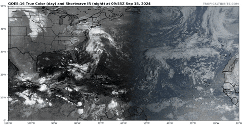
Regardless of what models are saying could happen in the 7-14 day time frame, it's kind of shocking to see the MDR and Caribbean/Gulf (especially the MDR) completely barren of convective activity in the middle of September like this:
6 likes
-
Category5Kaiju

- Category 5

- Posts: 4330
- Joined: Thu Dec 24, 2020 12:45 pm
- Location: Seattle and Phoenix
Re: 2024 Global Model Runs Discussion (Out thru day 16)
Yes, I know it's Happy Hour, but most recent GFS seems to like an MDR wave that exits the African coast early next week. Turns it into a decent-strength, westward-tracking hurricane
0 likes
Unless explicitly stated, all info in my posts is based on my own opinions and observations. Tropical storms and hurricanes can be extremely dangerous. Refer to an accredited weather research agency or meteorologist if you need to make serious decisions regarding an approaching storm.

Re: 2024 Global Model Runs Discussion (Out thru day 16)
Category5Kaiju wrote:Yes, I know it's Happy Hour, but most recent GFS seems to like an MDR wave that exits the African coast early next week. Turns it into a decent-strength, westward-tracking hurricane
2 likes
TC naming lists: retirements and intensity
Most aggressive Advisory #1's in North Atlantic (cr. kevin for starting the list)
Most aggressive Advisory #1's in North Atlantic (cr. kevin for starting the list)
Re: 2024 Global Model Runs Discussion (Out thru day 16)
This is gonna make up for some ACE big time if it plays out verbatim.
4 likes
TC naming lists: retirements and intensity
Most aggressive Advisory #1's in North Atlantic (cr. kevin for starting the list)
Most aggressive Advisory #1's in North Atlantic (cr. kevin for starting the list)
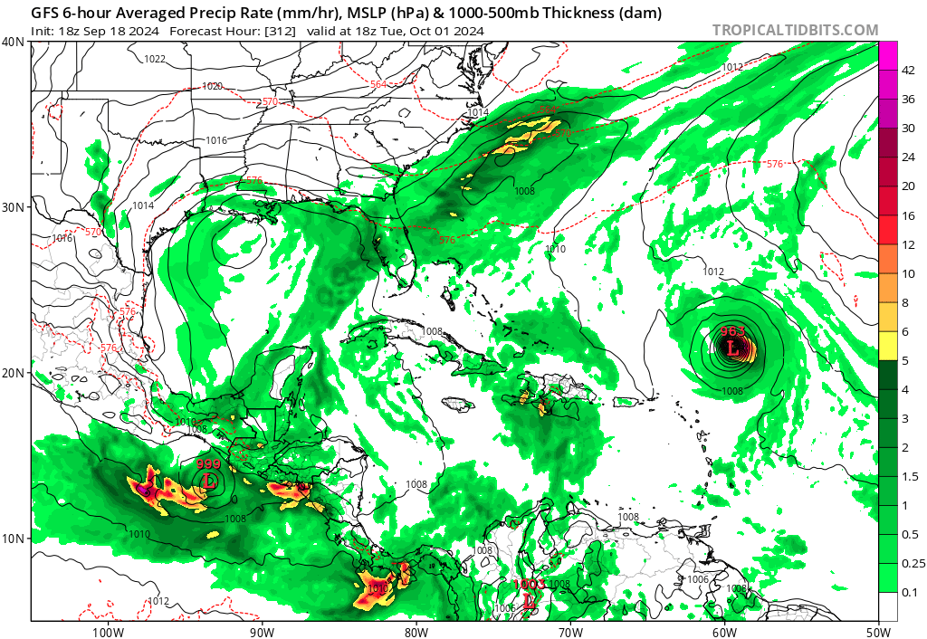
Re: 2024 Global Model Runs Discussion (Out thru day 16)
Teban54 wrote:This is gonna make up for some ACE big time if it plays out verbatim.
https://i.postimg.cc/4yYRLT36/image.png
Actually, right after this frame... What the %#$%#@!$~#$%?????
4 likes
TC naming lists: retirements and intensity
Most aggressive Advisory #1's in North Atlantic (cr. kevin for starting the list)
Most aggressive Advisory #1's in North Atlantic (cr. kevin for starting the list)

Re: 2024 Global Model Runs Discussion (Out thru day 16)
Teban54 wrote:Teban54 wrote:This is gonna make up for some ACE big time if it plays out verbatim.
https://i.postimg.cc/4yYRLT36/image.png
Actually, right after this frame... What the %#$%#@!$~#$%?????
https://i.postimg.cc/qR6vqYfv/gfs-mslp-pcpn-atl-fh234-378.gif
Incredibly unlikely but would be wild if that setting played out, especially in early October. Don’t think a storm coming from north of 30N has hit the Antilles this late in the season that we know of.
2 likes

Re: 2024 Global Model Runs Discussion (Out thru day 16)
How 'bout that? A 0Z Happy Hour Special
1 likes
Andy D
(For official information, please refer to the NHC and NWS products.)
(For official information, please refer to the NHC and NWS products.)
-
eastcoastFL

- Category 5
- Posts: 3996
- Age: 44
- Joined: Thu Apr 12, 2007 12:29 pm
- Location: Palm City, FL
Re: 2024 Global Model Runs Discussion (Out thru day 16)
Teban54 wrote:Teban54 wrote:This is gonna make up for some ACE big time if it plays out verbatim.
https://i.postimg.cc/4yYRLT36/image.png
Actually, right after this frame... What the %#$%#@!$~#$%?????
https://i.postimg.cc/qR6vqYfv/gfs-mslp-pcpn-atl-fh234-378.gif
That has got to be some kind of error, right?
0 likes
Personal Forecast Disclaimer:
The posts in this forum are NOT official forecast and should not be used as such. They are just the opinion of the poster and may or may not be backed by sound meteorological data. They are NOT endorsed by any professional institution or storm2k.org. For official information, please refer to the NHC and NWS products.
The posts in this forum are NOT official forecast and should not be used as such. They are just the opinion of the poster and may or may not be backed by sound meteorological data. They are NOT endorsed by any professional institution or storm2k.org. For official information, please refer to the NHC and NWS products.

Re: 2024 Global Model Runs Discussion (Out thru day 16)
06z GFS once again quite active with two major systems (WCar/GOM and MDR) and some weak slop with ex-Gordon and two other disturbances. Those weak storms might be able to get 1 - 5 ACE combined depending on which ones form and how long they stick around. Using the 0z GFS and converting to wind speed from pressure using Dvorak, the WCar/GOM system would get about 20 ACE and the MDR system would generate about 33 ACE out to +384 hrs. And there's also a quick low-end cat 1 spin-up in the WCar at the very end of the run. Combining all of this would generate 55 ACE over the next 16 days and this would put us at 116 ACE by October 5. Would be quite impressive and still gives plenty of time in October for an above-average season. One more MH in October would then be sufficient for an above-average season and 2 or 3 MHs could even still take us to hyperactivity. But it's 2024 we're talking about, perhaps in 3 days models will be postponing or cancelling development again  .
.
3 likes
Re: 2024 Global Model Runs Discussion (Out thru day 16)
35 out of 51 EPS members (69%) show a TD in the eastern MDR by day 7 (+168 hrs). GEFS even has 26 out of 31 members (84%) showing something by day 6 (+144 hrs). ICON and CMC are still a bit uncertain though. I still expect an eastern MDR lemon soon, perhaps already later today if both the 12z Euro and GFS ensembles consistently show this system.
1 likes
-
MHC Tracking
- Tropical Storm

- Posts: 203
- Joined: Mon Mar 15, 2021 10:05 am
Re: 2024 Global Model Runs Discussion (Out thru day 16)
Teban54 wrote:This is gonna make up for some ACE big time if it plays out verbatim.
https://i.postimg.cc/4yYRLT36/image.png
Even the often "downcasty" 06z run maintains a similar idea (though, IMO, it overbroadens the GoM system over the Yuctatan)

1 likes
-
Category5Kaiju
- Category 5
- Posts: 4330
- Joined: Thu Dec 24, 2020 12:45 pm
- Location: Seattle and Phoenix
Re: 2024 Global Model Runs Discussion (Out thru day 16)
tiger_deF wrote:Teban54 wrote:Teban54 wrote:This is gonna make up for some ACE big time if it plays out verbatim.
https://i.postimg.cc/4yYRLT36/image.png
Actually, right after this frame... What the %#$%#@!$~#$%?????
https://i.postimg.cc/qR6vqYfv/gfs-mslp-pcpn-atl-fh234-378.gif
Incredibly unlikely but would be wild if that setting played out, especially in early October. Don’t think a storm coming from north of 30N has hit the Antilles this late in the season that we know of.
No indeed. Getting an Irma-like track that late in the year would indeed be insane stuff
1 likes
Unless explicitly stated, all info in my posts is based on my own opinions and observations. Tropical storms and hurricanes can be extremely dangerous. Refer to an accredited weather research agency or meteorologist if you need to make serious decisions regarding an approaching storm.
Re: 2024 Global Model Runs Discussion (Out thru day 16)
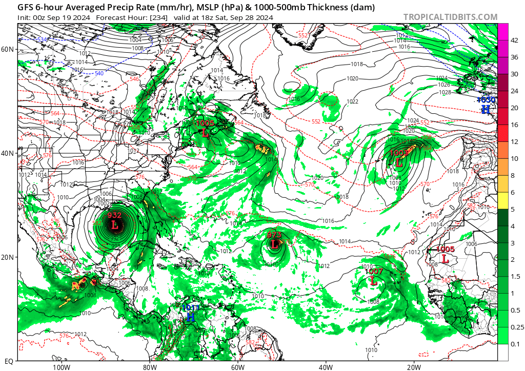
06z GEFS ensemble, looks a little more like what we probably all expected for September a few months ago. Besides the main WCar & MDR signals there are also a two short-term clusters in the subtropics (+ ex-Gordon) and two additional MDR signals in the second half of the timeframe.

4 likes

Re: 2024 Global Model Runs Discussion (Out thru day 16)
kevin wrote:06z GEFS ensemble, looks a little more like what we probably all expected for September a few months ago. Besides the main WCar & MDR signals there are also a two short-term clusters in the subtropics (+ ex-Gordon) and two additional MDR signals in the second half of the timeframe.
https://i.imgur.com/7I3Wy8y.png
If this pans out, I guess the predictions of a significant back-loaded season and delayed MDR activity were right. It would also probably be enough to get us up to 100-120 ACE.
2 likes
Irene '11 Sandy '12 Hermine '16 5/15/2018 Derecho Fay '20 Isaias '20 Elsa '21 Henri '21 Ida '21
I am only a meteorology enthusiast who knows a decent amount about tropical cyclones. Look to the professional mets, the NHC, or your local weather office for the best information.
I am only a meteorology enthusiast who knows a decent amount about tropical cyclones. Look to the professional mets, the NHC, or your local weather office for the best information.
-
Category5Kaiju
- Category 5
- Posts: 4330
- Joined: Thu Dec 24, 2020 12:45 pm
- Location: Seattle and Phoenix
Re: 2024 Global Model Runs Discussion (Out thru day 16)
12z GFS: Return of the Irma
1 likes
Unless explicitly stated, all info in my posts is based on my own opinions and observations. Tropical storms and hurricanes can be extremely dangerous. Refer to an accredited weather research agency or meteorologist if you need to make serious decisions regarding an approaching storm.
-
AnnularCane

- S2K Supporter

- Posts: 2957
- Joined: Thu Jun 08, 2006 9:18 am
- Location: Wytheville, VA
Re: 2024 Global Model Runs Discussion (Out thru day 16)
Category5Kaiju wrote:12z GFS: Return of the Irma
Oh my goodness, that's a different one!
0 likes
"But it never rained rain. It never snowed snow. And it never blew just wind. It rained things like soup and juice. It snowed mashed potatoes and green peas. And sometimes the wind blew in storms of hamburgers." -- Judi Barrett, Cloudy with a Chance of Meatballs


Re: 2024 Global Model Runs Discussion (Out thru day 16)
Forgive the level 101 question, and moderators feel free to delete this if you prefer.
I'm wondering why there's no thread for the 2pm 10/20 lemon in the Atlantic? It's possible there is one, and I didn't see it.
Chances too low?
Not gonna develop?
I'm wondering why there's no thread for the 2pm 10/20 lemon in the Atlantic? It's possible there is one, and I didn't see it.
Chances too low?
Not gonna develop?
0 likes
-
USTropics
- Professional-Met

- Posts: 2737
- Joined: Sun Aug 12, 2007 3:45 am
- Location: Florida State University
Re: 2024 Global Model Runs Discussion (Out thru day 16)
GlennOBX wrote:Forgive the level 101 question, and moderators feel free to delete this if you prefer.
I'm wondering why there's no thread for the 2pm 10/20 lemon in the Atlantic? It's possible there is one, and I didn't see it.
Chances too low?
Not gonna develop?
There is: https://www.storm2k.org/phpbb2/viewtopi ... 1&t=124319
The other highlighted area is for the remnants of Gordon: https://www.storm2k.org/phpbb2/viewtopi ... &start=120
0 likes
-
Stormlover70
- Tropical Storm
- Posts: 194
- Age: 56
- Joined: Fri Jun 21, 2024 5:31 am
- Location: New port richey
Re: 2024 Global Model Runs Discussion (Out thru day 16)
Where is Wxman57?. I would like his thoughts.
0 likes

Re: 2024 Global Model Runs Discussion (Out thru day 16)
REDHurricane wrote:Regardless of what models are saying could happen in the 7-14 day time frame, it's kind of shocking to see the MDR and Caribbean/Gulf (especially the MDR) completely barren of convective activity in the middle of September like this:
https://media4.giphy.com/media/v1.Y2lkPTc5MGI3NjExNnRxNW5wY2RoNHlqcXZ6bWhibGlpeDVmMGpmbjZjajl2dWVpeHllZiZlcD12MV9pbnRlcm5hbF9naWZfYnlfaWQmY3Q9Zw/pPadHtZSUGdu8zHv4h/giphy.gif
I don’t agree Red. It’s literally predictable and not shocking at all. There’s supposed to be sinking and stable air across most of the Atlantic. We been in Phases 4, 5 and 6 of the MJO since July 25th. These aren’t upward motion phases for the majority of the Atlantic though there are some minor corridors. But overall those phases don’t lend to multiple storms across the Atlantic.
0 likes
Who is online
Users browsing this forum: No registered users and 181 guests