ATL: HELENE - Post-Tropical - Discussion

Moderator: S2k Moderators

Message
Author
canes92
Tropical Storm
Tropical Storm
Posts: 127
Age: 32
Joined: Tue Mar 06, 2018 1:51 pm

Re: ATL: HELENE - Hurricane - Discussion

#2601 Postby canes92 » Thu Sep 26, 2024 10:37 am

Poonwalker wrote:Overall Tampa is again dodging the bullet. In this case maybe even a cannon. Iam just hoping water doesn’t enter homes. Difference of 10 miles eastern right now could be difference of garage getting lapped vs having inches of water throughout the floors. Also hoping we don’t get power outages. Irma left us without power for a week and it really sucked.


Tampa will never get another hurricane again.
1 likes   

User avatar
Zonacane
Category 1
Category 1
Posts: 361
Joined: Tue Aug 03, 2021 2:23 pm

Re: ATL: HELENE - Hurricane - Discussion

#2602 Postby Zonacane » Thu Sep 26, 2024 10:38 am

Image
Helene still dealing with mid-level dry air, those aren't RH values that produce a major hurricane.
0 likes   

xironman
S2K Supporter
S2K Supporter
Posts: 2522
Joined: Sun Jun 10, 2007 4:53 pm
Location: NoVA

Re: ATL: HELENE - Hurricane - Discussion

#2603 Postby xironman » Thu Sep 26, 2024 10:38 am

tolakram wrote:saved loop - this does not look like a storm that is having trouble intensifying.

https://i.imgur.com/QyvOTg0.gif

source: https://weather.cod.edu/satrad/?parms=m ... =undefined


It will be intensifying into landfall, that and the huge (where did that come from in September?) cutoff low adding baroclinic enhancement to the system should make TS force winds penetrate deep inland.
2 likes   

User avatar
Blown Away
S2K Supporter
S2K Supporter
Posts: 10147
Joined: Wed May 26, 2004 6:17 am

Re: ATL: HELENE - Hurricane - Discussion

#2604 Postby Blown Away » Thu Sep 26, 2024 10:39 am

Image

Meanwhile in the GOM…
8 likes   
Hurricane Eye Experience: David 79, Irene 99, Frances 04, Jeanne 04, Wilma 05... EYE COMING MY WAY IN 2024…
Hurricane Brush Experience: Andrew 92, Erin 95, Floyd 99, Matthew 16, Irma 17, Ian 22, Nicole 22…

tolakram
Admin
Admin
Posts: 20012
Age: 62
Joined: Sun Aug 27, 2006 8:23 pm
Location: Florence, KY (name is Mark)

Re: ATL: HELENE - Hurricane - Discussion

#2605 Postby tolakram » Thu Sep 26, 2024 10:41 am

canes92 wrote:
Poonwalker wrote:Overall Tampa is again dodging the bullet. In this case maybe even a cannon. Iam just hoping water doesn’t enter homes. Difference of 10 miles eastern right now could be difference of garage getting lapped vs having inches of water throughout the floors. Also hoping we don’t get power outages. Irma left us without power for a week and it really sucked.


Tampa will never get another hurricane again.


The US will never get hit by a major hurricane again.
The big bend area of Florida will never get hit by a hurricane again.
Tampa will never get hit by hurricane again.

Congrats for making it to the list. :lol:
18 likes   
M a r k
- - - - -
Join us in chat: Storm2K Chatroom Invite. Android and IOS apps also available.

The posts in this forum are NOT official forecasts and should not be used as such. Posts are NOT endorsed by any professional institution or STORM2K.org. For official information and forecasts, please refer to NHC and NWS products.

FLLurker32
Tropical Storm
Tropical Storm
Posts: 245
Joined: Mon Aug 29, 2016 10:31 am

Re: ATL: HELENE - Hurricane - Discussion

#2606 Postby FLLurker32 » Thu Sep 26, 2024 10:42 am

NDG wrote:From my good friend Pro Met T Scott:

Your boys are TOO FAR WEST with their landfall, Deni.
T. Scott believes this will PASS EAST of Apalachee Bay; NOT WEST.

2 Vort. Lobes circulating the base of the upper low/trough 1st heads SE from coastal MS/AL at 7 AM this morning. This should result in the first turn N-NE. 2nd vort. lobe comes this afternoon, emanating EASTward from Western AL/Cstl AL/SE LA bootip. diving Eastward.

The natural gravitation towards STEEP DEEPENING and strengthening will also tend to reflect a right-ward CURVE to the Northeast.

("Where abouts, T. Scott?") Central Taylor County coastline, near Dekle Beach, FL.

Only thing I do agree upon, with your favorite NHC boyz, is the STAUNCH bold prediction of a Cat. 4 135 mph hurricane.
AND that is a BOLD, GUTSY prediction BECAUSE IF you examine the ATCF 00Z suite, 9/26, NONE of them go above 115 mph, except an old, deprecated statistical model DRCL.


All of our Mets in North Central FL have been saying similar. They’ve had to ride a fine line of sharing the NHC official track but also the social responsibility of preparing viewers for the impact of a slight East shift.

Doesn’t matter on the grand scale, but for those of us closer to the west coast as it comes in it can be the difference between 40mph vs. 80mph winds.
2 likes   
Heather

User avatar
ElectricStorm
Category 5
Category 5
Posts: 5049
Age: 24
Joined: Tue Aug 13, 2019 11:23 pm
Location: Skiatook, OK / Norman, OK

Re: ATL: HELENE - Hurricane - Discussion

#2607 Postby ElectricStorm » Thu Sep 26, 2024 10:45 am

Still not much in terms of pressure drops with 962mb extrap. Looks to be holding steady with a large dry slot developing on the SE side
1 likes   
B.S Meteorology, University of Oklahoma '25

Please refer to the NHC, NWS, or SPC for official information.

User avatar
Travorum
Category 1
Category 1
Posts: 406
Joined: Tue Sep 05, 2023 9:36 am
Location: Dunedin, FL

Re: ATL: HELENE - Hurricane - Discussion

#2608 Postby Travorum » Thu Sep 26, 2024 10:46 am

SAR frustratingly missing the eastern eyewall but still measured 95kts in the part of the NE quadrant it captured, 4 hours ago:

Image
Platform: RCM-3
Acquisition Date: 2024-09-26 11:50:06 UTC
Storm Name: AL092024 / HELENE
Storm ID: AL09
Storm Center Longitude: -85.861
Storm Center Latitude: 24.721
Incidence Angle (Degrees): 20.702
Quadrant 1 NE VMax (kts): 95.12
Quadrant 2 SE VMax (kts): 79.61
Quadrant 3 SW VMax (kts): 70.36
Quadrant 4 NW VMax (kts): 82.92
RMax (nmi): 18.00 - 32.00
Last edited by Travorum on Thu Sep 26, 2024 10:47 am, edited 1 time in total.
4 likes   

TomballEd
Category 2
Category 2
Posts: 734
Age: 61
Joined: Wed Aug 16, 2023 4:52 pm
Location: Spring/Klein area, not Tomball

Re: ATL: HELENE - Hurricane - Discussion

#2609 Postby TomballEd » Thu Sep 26, 2024 10:46 am

The wobbles in stronger hurricanes are called, IIRC (and spelling ir correctly) are trochoidal wobbles. The mean motion is in a certain direction, but there will be small little loops along the way. It is when a wobble becomes a trend, not a wobble, that concerns about a shift in the track should begin.
0 likes   

User avatar
NDG
S2K Supporter
S2K Supporter
Posts: 15446
Joined: Sun Jul 09, 2006 10:14 pm
Location: Orlando, FL

Re: ATL: HELENE - Hurricane - Discussion

#2610 Postby NDG » Thu Sep 26, 2024 10:47 am

12z GFS also shifted slightly east, to the Taylor/Dixie County line.
0 likes   

Sanibel
Category 5
Category 5
Posts: 10375
Joined: Mon Aug 30, 2004 11:06 pm
Location: Offshore SW Florida

ATL: HELENE - Hurricane - Discussion

#2611 Postby Sanibel » Thu Sep 26, 2024 10:48 am

Loop Current boosting vs Gulf Syndrome...
2 likes   

FrontRunner
Tropical Depression
Tropical Depression
Posts: 62
Age: 41
Joined: Wed Aug 23, 2006 9:01 pm
Location: Westchester, NY

Re: ATL: HELENE - Hurricane - Discussion

#2612 Postby FrontRunner » Thu Sep 26, 2024 10:50 am

FLLurker32 wrote:
NDG wrote:From my good friend Pro Met T Scott:

Your boys are TOO FAR WEST with their landfall, Deni.
T. Scott believes this will PASS EAST of Apalachee Bay; NOT WEST.

2 Vort. Lobes circulating the base of the upper low/trough 1st heads SE from coastal MS/AL at 7 AM this morning. This should result in the first turn N-NE. 2nd vort. lobe comes this afternoon, emanating EASTward from Western AL/Cstl AL/SE LA bootip. diving Eastward.

The natural gravitation towards STEEP DEEPENING and strengthening will also tend to reflect a right-ward CURVE to the Northeast.

("Where abouts, T. Scott?") Central Taylor County coastline, near Dekle Beach, FL.

Only thing I do agree upon, with your favorite NHC boyz, is the STAUNCH bold prediction of a Cat. 4 135 mph hurricane.
AND that is a BOLD, GUTSY prediction BECAUSE IF you examine the ATCF 00Z suite, 9/26, NONE of them go above 115 mph, except an old, deprecated statistical model DRCL.


All of our Mets in North Central FL have been saying similar. They’ve had to ride a fine line of sharing the NHC official track but also the social responsibility of preparing viewers for the impact of a slight East shift.

Doesn’t matter on the grand scale, but for those of us closer to the west coast as it comes in it can be the difference between 40mph vs. 80mph winds.


If you're north of Anclote, you've already been warned about the likelihood of 80 mph winds. If you're north of Englewood, you've already been told about the possibility of 80 mph winds.
2 likes   

jdjaguar
Category 2
Category 2
Posts: 551
Joined: Fri Aug 26, 2005 12:07 pm
Location: Jacksonville Beach, FL

Re: ATL: HELENE - Hurricane - Discussion

#2613 Postby jdjaguar » Thu Sep 26, 2024 10:50 am

Poonwalker wrote:Overall Tampa is again dodging the bullet. In this case maybe even a cannon. Iam just hoping water doesn’t enter homes. Difference of 10 miles eastern right now could be difference of garage getting lapped vs having inches of water throughout the floors. Also hoping we don’t get power outages. Irma left us without power for a week and it really sucked.

Water is already a foot deep in homes at Indian Rocks per my son
1 likes   

Frank P
S2K Supporter
S2K Supporter
Posts: 2776
Joined: Fri Aug 29, 2003 10:52 am
Location: Biloxi Beach, Ms
Contact:

Re: ATL: HELENE - Hurricane - Discussion

#2614 Postby Frank P » Thu Sep 26, 2024 10:50 am

Image
9 likes   

longhorn2004
Tropical Depression
Tropical Depression
Posts: 61
Joined: Fri Oct 06, 2017 1:49 pm

Re: ATL: HELENE - Hurricane - Discussion

#2615 Postby longhorn2004 » Thu Sep 26, 2024 10:53 am

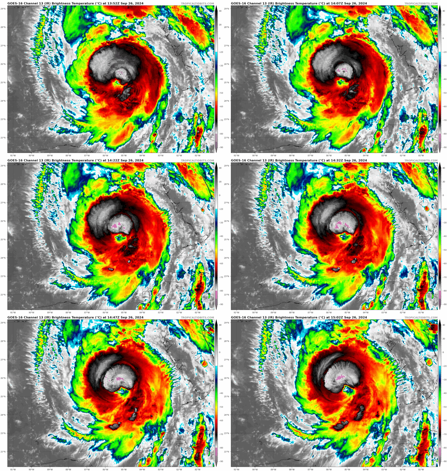
Is the grey area around the eye dry air being sucked in?
0 likes   

psyclone
S2K Supporter
S2K Supporter
Posts: 4763
Joined: Wed Aug 24, 2005 9:04 pm
Location: palm harbor fl

Re: ATL: HELENE - Hurricane - Discussion

#2616 Postby psyclone » Thu Sep 26, 2024 10:54 am

jdjaguar wrote:
Poonwalker wrote:Overall Tampa is again dodging the bullet. In this case maybe even a cannon. Iam just hoping water doesn’t enter homes. Difference of 10 miles eastern right now could be difference of garage getting lapped vs having inches of water throughout the floors. Also hoping we don’t get power outages. Irma left us without power for a week and it really sucked.

Water is already a foot deep in homes at Indian Rocks per my son


This is likely to be a substantial water event on the west coast...water rise and large battering waves are going to hammer our beaches
0 likes   

tolakram
Admin
Admin
Posts: 20012
Age: 62
Joined: Sun Aug 27, 2006 8:23 pm
Location: Florence, KY (name is Mark)

Re: ATL: HELENE - Hurricane - Discussion

#2617 Postby tolakram » Thu Sep 26, 2024 10:54 am

longhorn2004 wrote:Is the grey area around the eye dry air being sucked in?

Cold cloud tops, see the scale on the right? Dry air would be lack of convection at the top of the scale.
4 likes   
M a r k
- - - - -
Join us in chat: Storm2K Chatroom Invite. Android and IOS apps also available.

The posts in this forum are NOT official forecasts and should not be used as such. Posts are NOT endorsed by any professional institution or STORM2K.org. For official information and forecasts, please refer to NHC and NWS products.

User avatar
Nimbus
Category 5
Category 5
Posts: 5303
Joined: Mon Jul 19, 2004 10:54 am

Re: ATL: HELENE - Hurricane - Discussion

#2618 Postby Nimbus » Thu Sep 26, 2024 10:55 am

FrontRunner wrote:
FLLurker32 wrote:
NDG wrote:From my good friend Pro Met T Scott:


All of our Mets in North Central FL have been saying similar. They’ve had to ride a fine line of sharing the NHC official track but also the social responsibility of preparing viewers for the impact of a slight East shift.

Doesn’t matter on the grand scale, but for those of us closer to the west coast as it comes in it can be the difference between 40mph vs. 80mph winds.


If you're north of Anclote, you've already been warned about the likelihood of 80 mph winds. If you're north of Englewood, you've already been told about the possibility of 80 mph winds.


Flight level winds are higher than what the buoys are experiencing.
*currently* Buoy 42026 shown with the flag is seeing 54 knot gusts which is 62 mph.
Helena is still intensifying though so I will be watching buoy 42036 for SSE winds

Image
Last edited by Nimbus on Thu Sep 26, 2024 10:55 am, edited 1 time in total.
2 likes   

User avatar
Weatherboy1
Category 5
Category 5
Posts: 1189
Age: 49
Joined: Mon Jul 05, 2004 1:50 pm
Location: Jupiter/Sarasota, FL

Re: ATL: HELENE - Hurricane - Discussion

#2619 Postby Weatherboy1 » Thu Sep 26, 2024 10:55 am

That extremely deep and circular core of storms has almost wrapped around the eye. That’s going to signal a final round of serious intensification unfortunately IMO
1 likes   

User avatar
johngaltfla
Category 5
Category 5
Posts: 2069
Joined: Sun Jul 10, 2005 9:17 pm
Location: Sarasota County, FL
Contact:

Re: ATL: HELENE - Hurricane - Discussion

#2620 Postby johngaltfla » Thu Sep 26, 2024 10:55 am

NDG wrote:12z GFS also shifted slightly east, to the Taylor/Dixie County line.


Like I've said all week, Cedar Key to Steinhatchee area. Which is what the ICON model called for. I think the recent motion indicates that might just validate.
3 likes   


Return to “2024”

Who is online

Users browsing this forum: No registered users and 1 guest