ATL: MILTON - Models
Moderator: S2k Moderators

Re: ATL: MILTON - Models
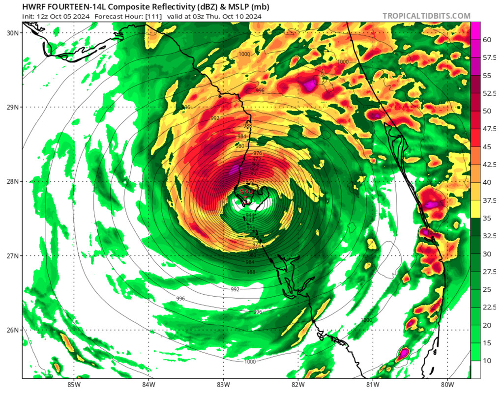
Hurricane models are showing huge rain numbers for the Jacksonville metro area. Add in the likely surge and wind, and...
0 likes

Re: ATL: MILTON - Models
12z, Oct 5, hurricane model blend, 92L
--- Model peak intensity ---
HWRF = 923mb/130kt
HMON = 924mb/134kt
HAFS-A = 942mb/108kt
HAFS-B = 918mb/145kt
--- Hurricane model blend ---
As hurricane models also indicate 92L has now intensified into TS Milton. In about 30 hours Milton is forecast to reach hurricane strength. All hurricane models show a MH peak this cycle with even high-end cat 4 and cat 5 peaks. This time HAFS-A is the weakest model with a 108 kt system and strong weakening to a 72 kt hurricane just before landfall. Landfall time is still uncertain with HWRF/HMON showing landfall around +114/+120 and HAFS-A/B already showing landfall around +96/+102. Due to this no landfall timestamp is shown in the blend and the blend is not an accurate estimate for the landfall intensity. Blending the intensity of the 4 models in their respective last frame before landfall results in a landfall blend of 941mb/108kt.
Blend
PEAK: 932 mb @ 90 hrs | 121 kt @ 90 hrs
ACE (0 - 126 hrs) = 15.3
hr / pressure (mb) / wind (kt)
00 / 1005 / 30
06 / 1001 / 42 - TS
12 / 999 / 40
18 / 997 / 42
24 / 991 / 52
30 / 987 / 59
36 / 981 / 65 - C1
42 / 976 / 72
48 / 969 / 75
54 / 965 / 76
60 / 957 / 88 - C2
66 / 946 / 99 - C3
72 / 944 / 99
78 / 941 / 112
84 / 934 / 121 - C4
90 / 932 / 121
96 / 937 / 107
102 / 946 / 88
108 / 953 / 98
114 / 962 / 84
120 / 974 / 76
126 / 979 / 72
--- Previous blend analyses ---
06z, Oct 5: 940 mb / 108 kt
12z, Oct 5: 932 mb / 121 kt
Last edited by kevin on Sat Oct 05, 2024 2:20 pm, edited 2 times in total.
7 likes
-
Blown Away

- S2K Supporter

- Posts: 10253
- Joined: Wed May 26, 2004 6:17 am
Re: ATL: MILTON - Models
12z HWRF shifted S from 06z… Wow directly into TB…
3 likes
Hurricane Eye Experience: David 79, Irene 99, Frances 04, Jeanne 04, Wilma 05… Hurricane Brush Experience: Andrew 92, Erin 95, Floyd 99, Matthew 16, Irma 17, Ian 22, Nicole 22…
-
ConvergenceZone
.gif)
- Category 5

- Posts: 5241
- Joined: Fri Jul 29, 2005 1:40 am
- Location: Northern California
Re: ATL: MILTON - Models
Blown Away wrote:[url]https://i.postimg.cc/TPSSqV5p/IMG-0520.jpg [/url]
12z HWRF shifted S from 06z… Wow directly into TB…
I realize it's unlikely to come to pass, but between the location and strength, that truly would be a doomsday scenario.
3 likes
Re: ATL: MILTON - Models
ConvergenceZone wrote:Blown Away wrote:[url]https://i.postimg.cc/TPSSqV5p/IMG-0520.jpg [/url]
12z HWRF shifted S from 06z… Wow directly into TB…
I realize it's unlikely to come to pass, but between the location and strength, that truly would be a doomsday scenario.
HMON is worse for surge up the bay, but neither are good. HWRF Makes up for it with eyewall.

2 likes
-
SootyTern
- S2K Supporter
- Posts: 316
- Age: 57
- Joined: Sun Sep 05, 2004 5:09 pm
- Location: NYC (formerly Homestead, FL)
Re: ATL: INVEST 92L - Models
ronjon wrote:Amazing how quickly forecasts on intensity can change when just a few days ago wxman57 was doubting this system would be more than a frontal low. GFS and now the hurricane models (all that performed well on intensity with Helene) now pointing toward another major hurricane striking the west coast of Florida. This just makes me sick to my stomach here on the western side of the state.
Seriously. The Gulf thing was a lemon when I last looked at the computer this morning; spent a few hours out and about and come back to a named storm that could be a nasty hit within 5 days. Wherever it hits, none of y'all need it. We'll see how it plays out, but y'all are in my thoughts and I am hoping for the best!
3 likes
Disclaimer:
The posts in this forum are NOT official forecasts and should not be used as such. For official information, please refer to the NHC and NWS products.
Gulf Coast: Opal '95 Georges '98 / So Fla: Katrina '05 Wilma '05 Irma '17
The posts in this forum are NOT official forecasts and should not be used as such. For official information, please refer to the NHC and NWS products.
Gulf Coast: Opal '95 Georges '98 / So Fla: Katrina '05 Wilma '05 Irma '17
-
cycloneye

- Admin

- Posts: 149291
- Age: 69
- Joined: Thu Oct 10, 2002 10:54 am
- Location: San Juan, Puerto Rico
Re: ATL: MILTON - Models
Strongest run of ensembles of Euro yet.

4 likes
Visit the Caribbean-Central America Weather Thread where you can find at first post web cams,radars
and observations from Caribbean basin members Click Here
and observations from Caribbean basin members Click Here
Re: ATL: MILTON - Models
18z earlies, slight shift left (north), lot's of I-4 riders here.

Last edited by BobHarlem on Sat Oct 05, 2024 2:19 pm, edited 2 times in total.
3 likes
Re: ATL: MILTON - Models
I know we've talked about the stronger modeled storms are further north and weaker south, but it also looks like speed of the system (per the Euro ensembles) will play a role in N vs. S. impacts. Faster looks north. Slower looks more south.
2 likes
-
cycloneye
- Admin
- Posts: 149291
- Age: 69
- Joined: Thu Oct 10, 2002 10:54 am
- Location: San Juan, Puerto Rico
Re: ATL: MILTON - Models

1 likes
Visit the Caribbean-Central America Weather Thread where you can find at first post web cams,radars
and observations from Caribbean basin members Click Here
and observations from Caribbean basin members Click Here
-
Hypercane_Kyle

- Category 5
- Posts: 3465
- Joined: Sat Mar 07, 2015 7:58 pm
- Location: Cape Canaveral, FL
Re: ATL: MILTON - Models
I could be wrong but I think a slightly faster system (making landfall Wednesday morning before sunrise) could be stronger, as it might not have much of an opportunity to weaken due to dry air/strong shear.
1 likes
My posts are my own personal opinion, defer to the National Hurricane Center (NHC) and other NOAA products for decision making during hurricane season.

Re: ATL: MILTON - Models
Hypercane_Kyle wrote:I could be wrong but I think a slightly faster system (making landfall Wednesday morning before sunrise) could be stronger, as it might not have much of an opportunity to weaken due to dry air/strong shear.
Makes sense that something hitting earlier could be stronger as opposed to one that’s fading and interacting. The thing with shear though is the gradient can be strong where the airmasses meet which is likely to mean strong gusts farther north even if the right front quadrant looks more to be the SE portion of the system (technically could be ENE to ESE portion if the angle is right.
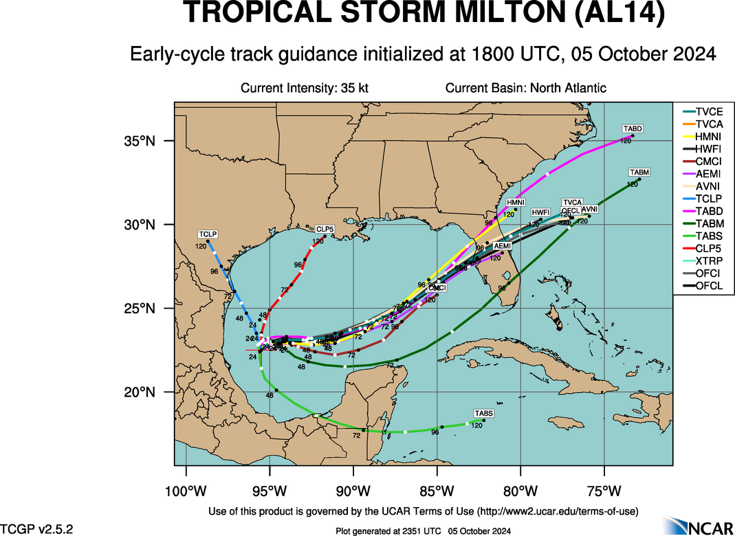
Early guidance 18z out and it’s honing in.
https://hurricanes.ral.ucar.edu/realtim ... _early.png
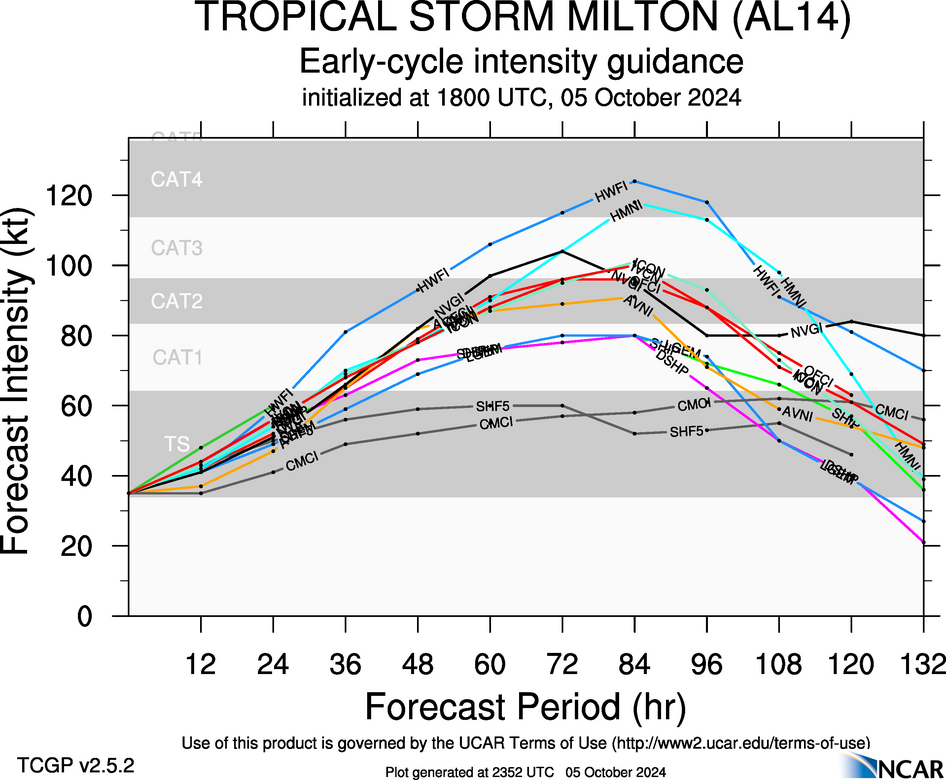
Early cycle intensity:
https://hurricanes.ral.ucar.edu/realtim ... _early.png
1 likes

Re: ATL: MILTON - Models
Close up look at latest 18z early tropical models. Expect a shift north over and narrowing of the cone by the next NHC advisory.
My heart aches for Tampa Bay.

My heart aches for Tampa Bay.
2 likes
-
Spacecoast

- Category 2

- Posts: 773
- Joined: Thu Aug 31, 2017 2:03 pm

Re: ATL: MILTON - Models
NDG wrote:Close up look at latest 18z early tropical models. Expect a shift north over and narrowing of the cone by the next NHC advisory.
My heart aches for Tampa Bay.
https://i.imgur.com/GrRXWe2.jpeg
I think there's more than 1 line bisecting my living room on that map.
0 likes
-
toad strangler

- S2K Supporter
- Posts: 4546
- Joined: Sun Jul 28, 2013 3:09 pm
- Location: Earth
- Contact:
Re: ATL: MILTON - Models
There is a large amount of real estate ahead of this thing. There will be more shifts.
3 likes
My Weather Station
https://www.wunderground.com/dashboard/pws/KFLPORTS603
https://www.wunderground.com/dashboard/pws/KFLPORTS603
-
AtlanticWind

- S2K Supporter
- Posts: 1898
- Age: 67
- Joined: Sun Aug 08, 2004 9:57 pm
- Location: Plantation,Fla
Re: ATL: MILTON - Models
NDG wrote:Close up look at latest 18z early tropical models. Expect a shift north over and narrowing of the cone by the next NHC advisory.
My heart aches for Tampa Bay.
https://i.imgur.com/GrRXWe2.jpeg
The cone size is not affected by models if I’m not mistaken
It is based on average error
8 likes
-
toad strangler
- S2K Supporter
- Posts: 4546
- Joined: Sun Jul 28, 2013 3:09 pm
- Location: Earth
- Contact:
Re: ATL: MILTON - Models
AtlanticWind wrote:NDG wrote:Close up look at latest 18z early tropical models. Expect a shift north over and narrowing of the cone by the next NHC advisory.
My heart aches for Tampa Bay.
https://i.imgur.com/GrRXWe2.jpeg
The cone size is not affected by models if I’m not mistaken
It is based on average error
True story. The cone has nothing to do with the confidence in forecast. It’s made up with circles of average margin of error over periods of time.
4 likes
My Weather Station
https://www.wunderground.com/dashboard/pws/KFLPORTS603
https://www.wunderground.com/dashboard/pws/KFLPORTS603
-
toad strangler
- S2K Supporter
- Posts: 4546
- Joined: Sun Jul 28, 2013 3:09 pm
- Location: Earth
- Contact:
Re: ATL: MILTON - Models
.
Last edited by toad strangler on Sat Oct 05, 2024 3:09 pm, edited 2 times in total.
0 likes
My Weather Station
https://www.wunderground.com/dashboard/pws/KFLPORTS603
https://www.wunderground.com/dashboard/pws/KFLPORTS603

Re: ATL: MILTON - Models
BobHarlem wrote:18z earlies, slight shift left (north), lot's of I-4 riders here.
https://i.imgur.com/BIJ92Sv.png
I'm beginning to wonder about the prospect for this continual northward shift to continue all the way to Cedar Key.
2 likes
Andy D
(For official information, please refer to the NHC and NWS products.)
(For official information, please refer to the NHC and NWS products.)
Who is online
Users browsing this forum: No registered users and 4 guests