Frank P wrote:HMON
https://i.ibb.co/wd0cSyR/hmon-mslp-wind-14-L-30.png
Yeah the HMON has been showing significant dissipation well before landfall on a few runs now.
Moderator: S2k Moderators

Frank P wrote:HMON
https://i.ibb.co/wd0cSyR/hmon-mslp-wind-14-L-30.png


StPeteMike wrote:I few like there is too many models depicting a track further north for the NHC not to nudge it a little more north at the 11 pm advisory. I totally get them not doing it at the 5 pm, but ICON now seems to be the outlier.


chris_fit wrote:18z Euro right up Tampa Bay


StPeteMike wrote:Blown Away wrote:chris_fit wrote:18z Euro right up Tampa Bay
The NE on the approach to @Tampa then somewhat an abrupt ENE turn across the state then into SW Atlantic seems a bit odd… I still think that track flattens out with a landfall closer to Ft. Myers then out near Ft. Pierce on a general NE track… JMHO
Ugh I hope that’s the case.
 Hurricanes: Andrew 1992 - Irene 1999 - Frances 2004 - Jeanne 2004 - Katrina 2005 - Wilma 2005 - Matthew 2016 - Irma 2017 - Ian 2022 - Nicole 2022 - Milton 2024
eastcoastFL wrote:I see that some models are showing significant weakening from whatever it turns out to be just before landfall. This is due to forecasted heavy shear. But I feel like I've been disappointed by shear forecasts too many times before. I feel like there's still too much time to put stock into that.
skillz305 wrote:StPeteMike wrote:Blown Away wrote:
The NE on the approach to @Tampa then somewhat an abrupt ENE turn across the state then into SW Atlantic seems a bit odd… I still think that track flattens out with a landfall closer to Ft. Myers then out near Ft. Pierce on a general NE track… JMHO
Ugh I hope that’s the case.
It's not nice to say that since i live right above fort pierce in vero
jfk08c wrote:Question for anyone who may have a better idea than me. When looking at the 10m winds on the model runs, they all seemingly disappear inland. Is that a quirk with the models or something? I find it hard to believe Central Florida won't see any significant winds from this


jfk08c wrote:Question for anyone who may have a better idea than me. When looking at the 10m winds on the model runs, they all seemingly disappear inland. Is that a quirk with the models or something? I find it hard to believe Central Florida won't see any significant winds from this

Kazmit wrote:jfk08c wrote:Question for anyone who may have a better idea than me. When looking at the 10m winds on the model runs, they all seemingly disappear inland. Is that a quirk with the models or something? I find it hard to believe Central Florida won't see any significant winds from this
The strongest winds rarely make their way very far inland. Land imparts a lot of friction on wind which makes it lose momentum. Windspeeds are highest at sea because there’s nothing to slow it down. Compare that to land with all of its trees, buildings, and terrain that all work to stop the wind.
Teban54 wrote:eastcoastFL wrote:I see that some models are showing significant weakening from whatever it turns out to be just before landfall. This is due to forecasted heavy shear. But I feel like I've been disappointed by shear forecasts too many times before. I feel like there's still too much time to put stock into that.
Even this year, Francine and Helene were expected to be weakened by shear just before landfall at various forecast points, and neither verified.
In some cases, such as Ian, the pre-landfall weakening were also purely academic.
cheezyWXguy wrote:Kazmit wrote:jfk08c wrote:Question for anyone who may have a better idea than me. When looking at the 10m winds on the model runs, they all seemingly disappear inland. Is that a quirk with the models or something? I find it hard to believe Central Florida won't see any significant winds from this
The strongest winds rarely make their way very far inland. Land imparts a lot of friction on wind which makes it lose momentum. Windspeeds are highest at sea because there’s nothing to slow it down. Compare that to land with all of its trees, buildings, and terrain that all work to stop the wind.
While I agree, I think the effect is over exaggerated on the models. Winds reduce substantially once you move inland from the coast, but it doesn’t drop from 100kt to 25kt in a couple of miles
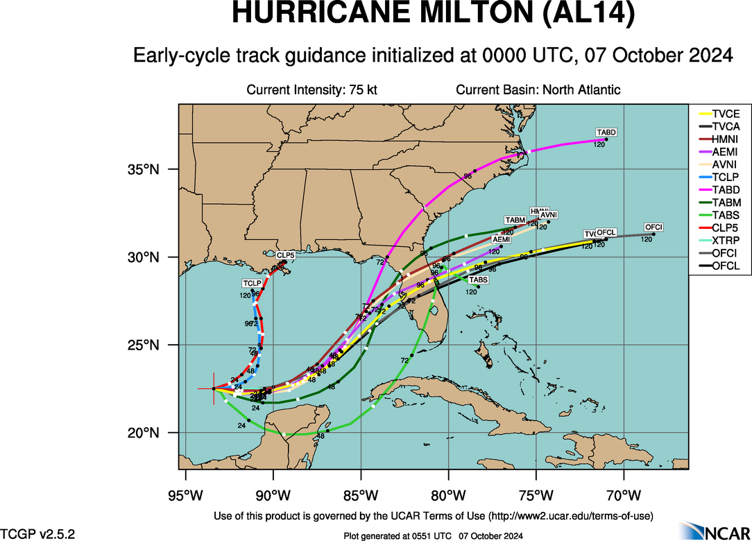
Steve wrote:Back to the models - early cycle guidance +/- Tampa and metro (ignore green tracks)
https://hurricanes.ral.ucar.edu/realtim ... _early.png
Late cycle EPS 18z the same
https://hurricanes.ral.ucar.edu/realtim ... l_late.png
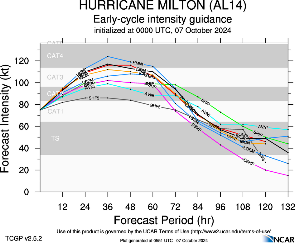
Early cycle intensity guidance is cat 3/4 but notice the falloff before landfall. Cat 1 or 2 based on those.
https://hurricanes.ral.ucar.edu/realtim ... _early.png


Users browsing this forum: No registered users and 10 guests


