2024 Global Model Runs Discussion (Out thru day 16)

This is the general tropical discussion area. Anyone can take their shot at predicting a storms path.

Moderator: S2k Moderators

Forum rules

The posts in this forum are NOT official forecasts and should not be used as such. They are just the opinion of the poster and may or may not be backed by sound meteorological data. They are NOT endorsed by any professional institution or STORM2K. For official information, please refer to products from the National Hurricane Center and National Weather Service.

Help Support Storm2K
Message
Author
underthwx
Category 5
Category 5
Posts: 2360
Joined: Sat Jul 30, 2011 2:14 pm
Location: Brazoria County Texas

Re: 2024 Global Model Runs Discussion (Out thru day 16)

#2321 Postby underthwx » Mon Oct 21, 2024 11:56 am

Travorum wrote:
emeraldislenc wrote:What might be the time frame for possible development?


Roughly averaging the most recent ensembles next Monday (Oct 28) would likely be the earliest time for development, with Tuesday-Wednesday being more likely. Given the high degree of consistency amongst ensembles and between runs, and with the MJO most likely going into a favorable phase, I would expect to see the NHC put up an AOI in the next few days.

Yeah.....I am watching for the NHC to eventually highlight the NW Caribbean for yet more possible development....based on everything I have been reading....as I said before....it just seems to be the way it is this season....with cyclone developmentin the NW Carribean....so I almost have expected it.....we shall see....
0 likes   

User avatar
SFLcane
S2K Supporter
S2K Supporter
Posts: 10163
Age: 47
Joined: Sat Jun 05, 2010 1:44 pm
Location: Lake Worth Florida

Re: 2024 Global Model Runs Discussion (Out thru day 16)

#2322 Postby SFLcane » Mon Oct 21, 2024 1:08 pm

Image
2 likes   

TomballEd
Category 2
Category 2
Posts: 692
Age: 61
Joined: Wed Aug 16, 2023 4:52 pm
Location: Spring/Klein area, not Tomball

Re: 2024 Global Model Runs Discussion (Out thru day 16)

#2323 Postby TomballEd » Mon Oct 21, 2024 1:13 pm


Last night's Euro ensembles seeing this means multiple model ensemble support. Canadian ensembles like this as well. At or just before the end of the month.

This season was indeed backloaded
2 likes   

User avatar
SFLcane
S2K Supporter
S2K Supporter
Posts: 10163
Age: 47
Joined: Sat Jun 05, 2010 1:44 pm
Location: Lake Worth Florida

Re: 2024 Global Model Runs Discussion (Out thru day 16)

#2324 Postby SFLcane » Mon Oct 21, 2024 2:18 pm

no bueno.. :eek:

Image

Image
Last edited by SFLcane on Mon Oct 21, 2024 2:50 pm, edited 1 time in total.
2 likes   

User avatar
SFLcane
S2K Supporter
S2K Supporter
Posts: 10163
Age: 47
Joined: Sat Jun 05, 2010 1:44 pm
Location: Lake Worth Florida

Re: 2024 Global Model Runs Discussion (Out thru day 16)

#2325 Postby SFLcane » Mon Oct 21, 2024 2:38 pm

Image
0 likes   

MarioProtVI
Category 4
Category 4
Posts: 935
Age: 24
Joined: Sun Sep 29, 2019 7:33 pm
Location: New Jersey

Re: 2024 Global Model Runs Discussion (Out thru day 16)

#2326 Postby MarioProtVI » Tue Oct 22, 2024 1:08 am

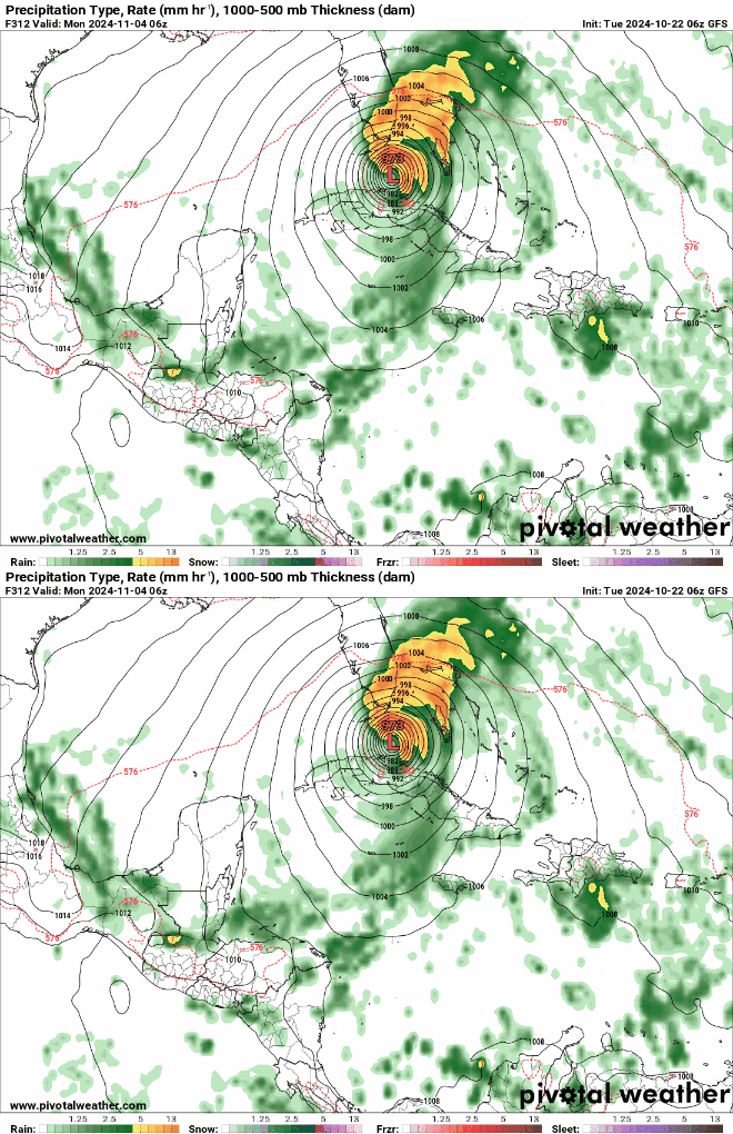
00z GFS wants a full blown Sandy 2.0 from the Caribbean into the Carolinas - literally checks off every box: late season Caribbean major, tracking close to Florida through Bahamas, gets super shot of energy from an approaching trough, merges with it and then bombs to 940s as it strikes the East Coast. And don’t forget the wintry precipitation of freezing rain too! And the same time of year and just prior to a close presidential election AND using the same name list as 2012. Would be really scary if we get 2 more storms before this one and it snagged the name Sara and wound up “Superstorm Sara”. Definitely one of the models runs that most likely won’t verify though, HOPEFULLY.
1 likes   

zhukm29
Category 1
Category 1
Posts: 279
Joined: Tue Aug 28, 2018 2:37 pm

Re: 2024 Global Model Runs Discussion (Out thru day 16)

#2327 Postby zhukm29 » Tue Oct 22, 2024 1:11 am

This is the fantasy GFS so likely won't happen, but the 00z casually has a hurricane swipe up the eastern seaboard on November 5 (in what is absolute unfortunate timing since this is election day), in an eerily similar manner as another storm back in 2012. Luckily this is extremely unlikely to verify this far out, but the Caribbean is definitely a place to watch during the first week of November, especially with the amplified MJO arriving in the basin. Would not be surprised to see something come out of there, since the Caribbean is forecasted to be extremely favorable the first week of November, alongside an amplified MJO and a CCKW passing through the region at the same time (and not the discount the record warmth there).

Image
Image

Here is the MJO forecast, with a highly amplified MJO arriving around Oct 31 in a phase that is conducive for development in the Atlantic.
Image

A convectively active CCKW will arrive at the same time:
Image

That, and the water in the Caribbean is much warmer than normal...
Image
3 likes   

User avatar
SFLcane
S2K Supporter
S2K Supporter
Posts: 10163
Age: 47
Joined: Sat Jun 05, 2010 1:44 pm
Location: Lake Worth Florida

Re: 2024 Global Model Runs Discussion (Out thru day 16)

#2328 Postby SFLcane » Tue Oct 22, 2024 6:05 am

Extreme South Florida certainly still in the game even this late in the season. Gotta keep watching let’s hope nothing forms.

Image
3 likes   

User avatar
Jr0d
S2K Supporter
S2K Supporter
Posts: 1409
Joined: Tue Aug 27, 2019 10:52 am
Location: Cayo Hueso

Re: 2024 Global Model Runs Discussion (Out thru day 16)

#2329 Postby Jr0d » Tue Oct 22, 2024 8:23 am

Well this is getting interesting. If I recall correctly just a few days ago we had folks saying the door has closed for a Florida landfall...

Still we are at least a week away from any potential development and at least 10 days from any potential Florida impact.

Certainly something to keep an eye on, but right now it us just a GFS model storm. If it is showing a possible S. Florida strike this far out, we can usually assume it will shift.

Given the time if the year, I would expect a right shift further east of Florida...still Cuba, Jamaica, The Island of Hispaniola and Puerto Rico also need to keep their eyes on this potential area of interest.
1 likes   

User avatar
SFLcane
S2K Supporter
S2K Supporter
Posts: 10163
Age: 47
Joined: Sat Jun 05, 2010 1:44 pm
Location: Lake Worth Florida

Re: 2024 Global Model Runs Discussion (Out thru day 16)

#2330 Postby SFLcane » Tue Oct 22, 2024 9:07 am

Jr0d wrote:Well this is getting interesting. If I recall correctly just a few days ago we had folks saying the door has closed for a Florida landfall...

Still we are at least a week away from any potential development and at least 10 days from any potential Florida impact.

Certainly something to keep an eye on, but right now it us just a GFS model storm. If it is showing a possible S. Florida strike this far out, we can usually assume it will shift.

Given the time if the year, I would expect a right shift further east of Florida...still Cuba, Jamaica, The Island of Hispaniola and Puerto Rico also need to keep their eyes on this potential area of interest.


Just speculating but florida will be very warm heading into Halloween with plenty of ridging overhead so its certainly within the realm of possibilities any tropical system that finds a north path could get steering back towards the conus.

Image

Image
3 likes   

Fancy1002
Tropical Storm
Tropical Storm
Posts: 134
Joined: Sun Dec 25, 2022 3:47 pm

Re: 2024 Global Model Runs Discussion (Out thru day 16)

#2331 Postby Fancy1002 » Tue Oct 22, 2024 9:37 am

Worst potential timing for a tropical impact on the latest GFS’s.
2 likes   

User avatar
MetroMike
Category 4
Category 4
Posts: 952
Joined: Sun Aug 29, 2004 8:13 pm
Location: Tampa Bay
Contact:

Re: 2024 Global Model Runs Discussion (Out thru day 16)

#2332 Postby MetroMike » Tue Oct 22, 2024 10:24 am

Fancy1002 wrote:Worst potential timing for a tropical impact on the latest GFS’s.


Yes the conus does not need more chaos around Nov 5th. Can only hope this is a phantom or goes OTS.
2 likes   

User avatar
Jr0d
S2K Supporter
S2K Supporter
Posts: 1409
Joined: Tue Aug 27, 2019 10:52 am
Location: Cayo Hueso

Re: 2024 Global Model Runs Discussion (Out thru day 16)

#2333 Postby Jr0d » Tue Oct 22, 2024 12:32 pm

SFLcane wrote:
Jr0d wrote:Well this is getting interesting. If I recall correctly just a few days ago we had folks saying the door has closed for a Florida landfall...

Still we are at least a week away from any potential development and at least 10 days from any potential Florida impact.

Certainly something to keep an eye on, but right now it us just a GFS model storm. If it is showing a possible S. Florida strike this far out, we can usually assume it will shift.

Given the time if the year, I would expect a right shift further east of Florida...still Cuba, Jamaica, The Island of Hispaniola and Puerto Rico also need to keep their eyes on this potential area of interest.


Just speculating but florida will be very warm heading into Halloween with plenty of ridging overhead so its certainly within the realm of possibilities any tropical system that finds a north path could get steering back towards the conus.

https://i.imgur.com/HChYUlc.png

https://i.imgur.com/s0oO7kp.gif


Until.we have at least an invest we are guessing. The latest GFS shows it going further east and much stronger the Canadian is weaker and showing it stay south, possibly towards the Yucatan.

I just realized the significance of the timing. Something to watch for sure..and if the latest GFS is right about intensity we could see a string cat 4 in November which is crazy.
2 likes   

Stormlover70
Tropical Storm
Tropical Storm
Posts: 175
Age: 55
Joined: Fri Jun 21, 2024 5:31 am
Location: New port richey

Re: 2024 Global Model Runs Discussion (Out thru day 16)

#2334 Postby Stormlover70 » Tue Oct 22, 2024 6:58 pm

Way too early to worry about a phantom....
1 likes   

User avatar
Hypercane_Kyle
Category 5
Category 5
Posts: 3352
Joined: Sat Mar 07, 2015 7:58 pm
Location: Cape Canaveral, FL

Re: 2024 Global Model Runs Discussion (Out thru day 16)

#2335 Postby Hypercane_Kyle » Wed Oct 23, 2024 5:49 am

Whole GFS scenario there just screams ghost storm, although the CMC is showing a little uptick in vorticity/moisture towards the end of its run.

Euro won't show anything so no point in looking at that.
1 likes   
My posts are my own personal opinion, defer to the National Hurricane Center (NHC) and other NOAA products for decision making during hurricane season.

underthwx
Category 5
Category 5
Posts: 2360
Joined: Sat Jul 30, 2011 2:14 pm
Location: Brazoria County Texas

Re: 2024 Global Model Runs Discussion (Out thru day 16)

#2336 Postby underthwx » Wed Oct 23, 2024 5:50 am

Im already seeing a couple different news agencies mentioning a new area of development possible in the NW Caribbean....one even has that area highlighted in yellow...which as of now...the NHC does not.....maybe a bit premature on their part perhaps?...im not sure how they decide to do that...before the experts at the NHC issue an official area of interest....
2 likes   

User avatar
SFLcane
S2K Supporter
S2K Supporter
Posts: 10163
Age: 47
Joined: Sat Jun 05, 2010 1:44 pm
Location: Lake Worth Florida

Re: 2024 Global Model Runs Discussion (Out thru day 16)

#2337 Postby SFLcane » Wed Oct 23, 2024 6:01 am

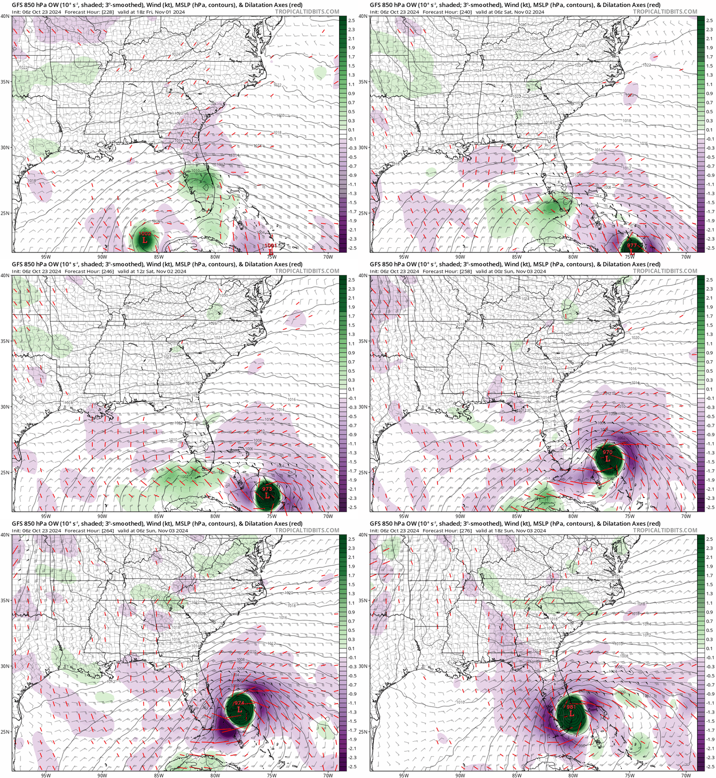
Nicole 2.0 on the lastest GFS but a bit stronger. Lots of possibilities still remain!

Image
1 likes   

User avatar
Jr0d
S2K Supporter
S2K Supporter
Posts: 1409
Joined: Tue Aug 27, 2019 10:52 am
Location: Cayo Hueso

Re: 2024 Global Model Runs Discussion (Out thru day 16)

#2338 Postby Jr0d » Wed Oct 23, 2024 6:35 am

Hypercane_Kyle wrote:Whole GFS scenario there just screams ghost storm, although the CMC is showing a little uptick in vorticity/moisture towards the end of its run.

Euro won't show anything so no point in looking at that.


The CMC showed a storm a few days ago and dropped it, however their ensembles are active, as are the euros.

However over all the ensembles are not as active as they were the past 2 days, it could be a one off or it could be a trend showing..

At the end of the free EURO there is something going on. I expect some activity starting around Halloween maybe earlier but whether it becomes an organized system is questionable. Way too early to speculate on s potential landfall threat.
0 likes   

Cachondo23
Tropical Depression
Tropical Depression
Posts: 75
Joined: Wed May 25, 2022 5:56 am

Re: 2024 Global Model Runs Discussion (Out thru day 16)

#2339 Postby Cachondo23 » Wed Oct 23, 2024 6:42 am

SFLcane wrote:Nicole 2.0 on the lastest GFS but a bit stronger. Lots of possibilities still remain!

https://i.postimg.cc/T1gdQkbp/IMG-9678.gif

Amazing GFS run, some type of Fujiwhara effect and straight to Miami from the NE then back to Cuba and Yucatan…
1 likes   

User avatar
Jr0d
S2K Supporter
S2K Supporter
Posts: 1409
Joined: Tue Aug 27, 2019 10:52 am
Location: Cayo Hueso

Re: 2024 Global Model Runs Discussion (Out thru day 16)

#2340 Postby Jr0d » Wed Oct 23, 2024 8:04 am

Cachondo23 wrote:
SFLcane wrote:Nicole 2.0 on the lastest GFS but a bit stronger. Lots of possibilities still remain!

https://i.postimg.cc/T1gdQkbp/IMG-9678.gif

Amazing GFS run, some type of Fujiwhara effect and straight to Miami from the NE then back to Cuba and Yucatan…


I am going to call that a happy hour run...a storm moving SW from Miami through the Florida Keys would be odd for anytime of the year. The 1935 Yankee hurricane had its origins in the mid Atlantic, likely a subtropical storm that became fully tropical as it dive south before moving west across Miami..

Never has a hurricane that originated in the Carribean hit Florida in November since we have been keeping records, though Michelle was close and is an example of how strong an early November hurricane can be in the Caribbean, peaking as a cat 4 and devastating Cuba.
1 likes   


Return to “Talkin' Tropics”

Who is online

Users browsing this forum: Europa non è lontana, Google Adsense [Bot], kenayers, Sciencerocks, StormWeather and 30 guests