Texas Winter 2024-2025
Moderator: S2k Moderators
Forum rules
 The posts in this forum are NOT official forecast and should not be used as such. They are just the opinion of the poster and may or may not be backed by sound meteorological data. They are NOT endorsed by any professional institution or STORM2K.

The posts in this forum are NOT official forecast and should not be used as such. They are just the opinion of the poster and may or may not be backed by sound meteorological data. They are NOT endorsed by any professional institution or STORM2K.

-
Yukon Cornelius
- S2K Supporter

- Posts: 1838
- Age: 42
- Joined: Thu Dec 20, 2012 9:23 pm
- Location: Dean, TX/Westcliffe, CO


Re: Texas Winter 2024-2025
Geez. I mean, if we’re trying to find a positive, there is still time for them to massively change again. All it took was 24 hours!
But yeah, the trend is not looking great at the moment.
At least there should be more opportunities later in the month. Its not over!!!
But yeah, the trend is not looking great at the moment.
At least there should be more opportunities later in the month. Its not over!!!
3 likes
Re: Texas Winter 2024-2025
cstrunk wrote:I'll just choose to ignore every model except the 06z Euro.
Are you able to share the map(s)?
0 likes
-
Brent
- S2K Supporter
- Posts: 38708
- Age: 37
- Joined: Sun May 16, 2004 10:30 pm
- Location: Tulsa Oklahoma
- Contact:
Re: Texas Winter 2024-2025
Yeah not liking the trends January has not been kind lately
Hopefully things turn around
Hopefully things turn around
0 likes
#neversummer
-
orangeblood
- S2K Supporter
- Posts: 3895
- Joined: Tue Dec 15, 2009 6:14 pm
- Location: Fort Worth, TX
Re: Texas Winter 2024-2025
To illustrate just how insane this is becoming. look at the precip charts now between the Euro and NAM
This is a difference of almost 140 miles between precip shields within 48 hours of a weather event. For DFW Airport, over an inch of precip on the Euro to a trace on the NAM


This is a difference of almost 140 miles between precip shields within 48 hours of a weather event. For DFW Airport, over an inch of precip on the Euro to a trace on the NAM
1 likes
-
bubba hotep

- S2K Supporter
- Posts: 6013
- Joined: Wed Dec 28, 2016 1:00 am
- Location: Collin County Texas
Re: Texas Winter 2024-2025
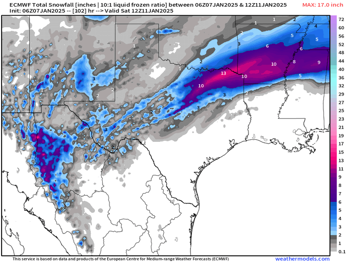
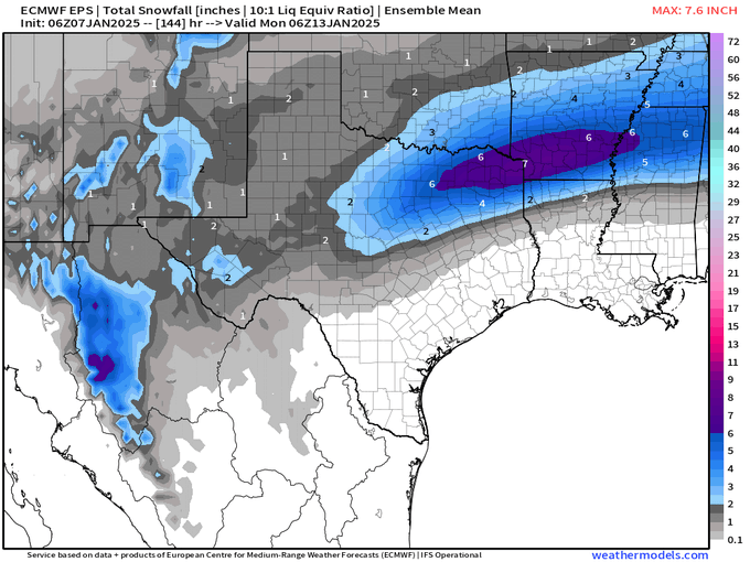
06z Euro still looks good for some.
2 likes
Winter time post are almost exclusively focused on the DFW area.

Re: Texas Winter 2024-2025
FWIW the ICON 12z now is doing basically what the NAM did.
4 likes
The above post and any post by Ntxw is NOT an official forecast and should not be used as such. It is just the opinion of the poster and may or may not be backed by sound meteorological data. It is NOT endorsed by any professional institution including Storm2k. For official information, please refer to NWS products.
Help support Storm2K!
-
Portastorm

- Storm2k Moderator

- Posts: 9954
- Age: 63
- Joined: Fri Jul 11, 2003 9:16 am
- Location: Round Rock, TX
- Contact:
Re: Texas Winter 2024-2025
Age old story my friends ... coastal lows always rob moisture from areas further inland in Texas. With the timing of the surface low development off the coast being closer to the timing of the upper level trough/vorticity moving across the state ... there you go. That is assuming it all shakes out like the most recent model runs show. I'm in the camp with orangeblood in that this is a very unusual model change so close to an event. I'm not sure I'm sold on any scenario at the moment.
10 likes
Any forecasts under my name are to be taken with a grain of salt. Get your best forecasts from the National Weather Service and National Hurricane Center.
-
orangeblood
- S2K Supporter
- Posts: 3895
- Joined: Tue Dec 15, 2009 6:14 pm
- Location: Fort Worth, TX
Re: Texas Winter 2024-2025
bubba hotep wrote:06z Euro still looks good for some.
https://pbs.twimg.com/media/Ggst5jNWwAAPf82?format=png&name=small
https://pbs.twimg.com/media/Ggst6rsXMAAI6Lu?format=png&name=small
There's literally 3 of 50 06Z Euro ensemble members showing this scenario depicted by the latest NAM
2 likes
-
HockeyTx82
- S2K Supporter
- Posts: 2775
- Joined: Tue Oct 27, 2009 11:17 am
- Location: Ponder, TX
Re: Texas Winter 2024-2025
Ntxw wrote:FWIW the ICON 12z now is doing basically what the NAM did.
So question, is the matching the eyeball test? I mean models are models, but if we look out the window or at real time data is what the models showing have true creedance?
Has a model ever said no rain or snow and yet you look out the window and it's raining or snowing?
1 likes
Don't hold me accountable for anything I post on this forum. Leave the real forecasting up to the professionals.
Location: Ponder, TX (all observation posts are this location unless otherwise noted)
Location: Ponder, TX (all observation posts are this location unless otherwise noted)
-
txtwister78

- Category 5

- Posts: 2146
- Joined: Wed Jan 30, 2019 12:56 pm
- Location: San Antonio
Re: Texas Winter 2024-2025
Good morning all...one of the things you're clearly seeing and it was something I mentioned a few days ago on here when models began to show a coastal low developing (Portastorm and I discussed this as well) was typically when that occurs you look for less QPF further north as the coastal low sort of draws in all the moisture and becomes the more dominant feature as it influences the system coming out of the SW. The trends have continued to show that especially across West Texas (my goodness).
However, in that transition zone you're also seeing more colder air in the upper levels filter in on that backend of this precip shield and so where there is enough qpf available you're beginning to see (NAM and Euro) a bit of a rain/snow transition late.
However, in that transition zone you're also seeing more colder air in the upper levels filter in on that backend of this precip shield and so where there is enough qpf available you're beginning to see (NAM and Euro) a bit of a rain/snow transition late.
3 likes
-
Brandon8181
- S2K Supporter
- Posts: 431
- Age: 42
- Joined: Tue Jan 04, 2011 4:52 pm
- Location: Tyler, TX
- Contact:
Re: Texas Winter 2024-2025
bubba hotep wrote:06z Euro still looks good for some.
https://pbs.twimg.com/media/Ggst5jNWwAAPf82?format=png&name=small
https://pbs.twimg.com/media/Ggst6rsXMAAI6Lu?format=png&name=small
This to me looks like the NWS likes the Euro which we know has seemed to be the favored one by many professional meteorologists. If you look at the 6z euro snow fall output looks very similar to winter weather watch.
5 likes
I am not a meteorologist. Any post from me should be taken as hobby or fun educational information, but not an accurate source for weather information. Please, refer to your local weather station or National Weather Service for the most up to date information. 
-
orangeblood
- S2K Supporter
- Posts: 3895
- Joined: Tue Dec 15, 2009 6:14 pm
- Location: Fort Worth, TX
Re: Texas Winter 2024-2025
Brandon8181 wrote:bubba hotep wrote:06z Euro still looks good for some.
https://pbs.twimg.com/media/Ggst5jNWwAAPf82?format=png&name=small
https://pbs.twimg.com/media/Ggst6rsXMAAI6Lu?format=png&name=small
This to me looks like the NWS likes the Euro which we know has seemed to be the favored one by many professional meteorologists. If you look at the 6z euro snow fall output looks very similar to winter weather watch.
Logic and reason tells you to stick with the one that's been the most consistent so until it caves (if), this is probably the forecast you stay with for now.
Latest RGEM isn't buying it and neither is the WRF, has heavy sleet/snow/frz rain streaming into North Texas Thursday morning


Last edited by orangeblood on Tue Jan 07, 2025 10:22 am, edited 1 time in total.
5 likes
-
bubba hotep
- S2K Supporter
- Posts: 6013
- Joined: Wed Dec 28, 2016 1:00 am
- Location: Collin County Texas
Re: Texas Winter 2024-2025
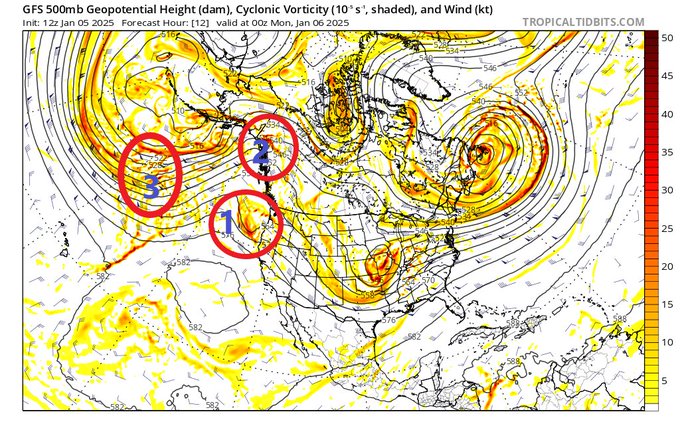
bubba hotep wrote:The Euro EPS seems locked in, but we still have a long way to go. We are still about 12 hrs from 1 & 2 moving onshore and getting sampled better (I wish they would have flown an upper-level mission over the North Pacific). Then 3 is still way out in the North Pacific. That makes me nervous as a lot can change as we wait for it to crash down the Rockies and into our system. Too many moving parts to make me feel good
This was tricky from the start the main players have not moved as forecasted (shocker)
However, the 12z RGEM doubled down!

3 likes
Winter time post are almost exclusively focused on the DFW area.
Re: Texas Winter 2024-2025
Yukon Cornelius wrote:Latest from Norman this morning
[url]https://i.ibb.co/k8BJGs5/IMG-9801.png [/url]
I’m in north Edmond. Thinking I’m going to get my usual flurries with little to no accumulation.
0 likes
-
Captmorg70
- Tropical Storm

- Posts: 206
- Age: 38
- Joined: Mon Dec 18, 2017 12:07 am
- Location: Highland Village Tx
Re: Texas Winter 2024-2025
Do we know when the northern part of the system that we are watching for the phase will be sampled? I assume that will be by tonight?
1 likes
Location - Highland Village
Re: Texas Winter 2024-2025
bubba hotep wrote:bubba hotep wrote:The Euro EPS seems locked in, but we still have a long way to go. We are still about 12 hrs from 1 & 2 moving onshore and getting sampled better (I wish they would have flown an upper-level mission over the North Pacific). Then 3 is still way out in the North Pacific. That makes me nervous as a lot can change as we wait for it to crash down the Rockies and into our system. Too many moving parts to make me feel good
https://pbs.twimg.com/media/GgjoHhTWkAAtu2m?format=jpg&name=small
This was tricky from the start the main players have not moved as forecasted (shocker)
However, the 12z RGEM doubled down!
https://m2o.pivotalweather.com/maps/models/rdps/2025010712/075/sn10_acc-imp.us_sc.png
The RGEM and EURO are pretty much outliers at this point...
Even the early frames of the HRRR are looking more NAM/GFS-ish...
2 likes

Re: Texas Winter 2024-2025
Hopping in here for a rare post, but while the NAM runs are concerning I wouldn't put all of my stock into it. We've had several events where the NAM deviated significantly from what happened in reality as it started to show the event in range. The model is really best at about 36 hours because for some reason, its solutions tend to diverge more chaotically as it gets farther away in simulation time from its initialization time. In modeling, something like a difference in a microphysics parameterization scheme can cause wildly different results when the overall physics are largely showing the same solution, and for the NAM's case, it is showing the track and speed of the low relatively consistent with the global models and even some of the other mesoscale models like the RGEM. Remember, when dealing with these events it's all about trends. As long as ensembles and other short range models show precipitation, there's reason to build trust that an event is possible, even if the incoming shortwave near Baja california is starting to indicate there will be overall a warmer airmass creeping into the plains which will decrease snow likelihood south of the red river. But, that being said, if the 12z NAM solution appears on the HRRR by tomorrow morning and starts to creep into ensembles more and more as the next 24 hours happens, I'd start to hit the panic button. However, there's no reason to do that yet--and the meteorologists at the local NWS offices around North Texas seem to agree.
12 likes
-
orangeblood
- S2K Supporter
- Posts: 3895
- Joined: Tue Dec 15, 2009 6:14 pm
- Location: Fort Worth, TX
Re: Texas Winter 2024-2025
snownado wrote:bubba hotep wrote:bubba hotep wrote:The Euro EPS seems locked in, but we still have a long way to go. We are still about 12 hrs from 1 & 2 moving onshore and getting sampled better (I wish they would have flown an upper-level mission over the North Pacific). Then 3 is still way out in the North Pacific. That makes me nervous as a lot can change as we wait for it to crash down the Rockies and into our system. Too many moving parts to make me feel good
https://pbs.twimg.com/media/GgjoHhTWkAAtu2m?format=jpg&name=small
This was tricky from the start the main players have not moved as forecasted (shocker)
However, the 12z RGEM doubled down!
https://m2o.pivotalweather.com/maps/models/rdps/2025010712/075/sn10_acc-imp.us_sc.png
The RGEM and EURO are pretty much outliers at this point...
Even the early frames of the HRRR are looking more NAM/GFS-ish...
Hi Res WRF is on the Euro side, there are no outliers at this point
1 likes
Who is online
Users browsing this forum: Stratton23 and 46 guests