
I really wish there was a North Texas and South Texas Thread….i get confused wondering who is who in here and if they are talking my area, Houston, or Dallas area, or Austin…. I know what affects one may affect all, But in different ways….i lookup where folks are from to find out. Just a suggestion….
I also find it difficult to know whether people are for snow and ice or against it….i am firmly in the against it column…but the kids are not.
Texas Winter 2024-2025
Moderator: S2k Moderators
Forum rules
 The posts in this forum are NOT official forecast and should not be used as such. They are just the opinion of the poster and may or may not be backed by sound meteorological data. They are NOT endorsed by any professional institution or STORM2K.

The posts in this forum are NOT official forecast and should not be used as such. They are just the opinion of the poster and may or may not be backed by sound meteorological data. They are NOT endorsed by any professional institution or STORM2K.
Re: Texas Winter 2024-2025
4 likes
All that wander are not lost... 
Babe, Bob, Danny,Juan
Betsy, Camille, Andrew
Ike, Rita,Harvey,Beryl
Babe, Bob, Danny,Juan
Betsy, Camille, Andrew
Ike, Rita,Harvey,Beryl


Re: Texas Winter 2024-2025
nlosrgr8 wrote:I really wish there was a North Texas and South Texas Thread….i get confused wondering who is who in here and if they are talking my area, Houston, or Dallas area, or Austin…. I know what affects one may affect all, But in different ways….i lookup where folks are from to find out. Just a suggestion….
I also find it difficult to know whether people are for snow and ice or against it….i am firmly in the against it column…but the kids are not.
You can make any thread you want if you want it to be for a specific area (unless that’s restricted in the winter subdirectory).
1 likes
-
Brazoria_cnty99
- Tropical Wave

- Posts: 8
- Joined: Sun Dec 29, 2024 12:47 pm
-
Charleswachal
- S2K Supporter

- Posts: 118
- Age: 35
- Joined: Tue Sep 27, 2022 11:24 pm
Re: Texas Winter 2024-2025
Brazoria_cnty99 wrote:When will our watches be upgraded to warnings?
Far southern texas by the Mexico border has already begun the upgrade. Most should be upgraded by the end of today
0 likes
Tropical Systems Experienced... Hurricane Harvey 2017 (Houston); Tropical Depression Imelda 2019 (Houston); Hurricane Nicolas 2021 (Houston), Hurricane Beryl 2024 (Eye Intercept)
-
txtwister78

- Category 5

- Posts: 2142
- Joined: Wed Jan 30, 2019 12:56 pm
- Location: San Antonio
Re: Texas Winter 2024-2025
Last edited by txtwister78 on Sun Jan 19, 2025 2:33 pm, edited 2 times in total.
5 likes
-
sphelps8681
- Category 2

- Posts: 785
- Joined: Thu Aug 16, 2007 5:37 pm
- Location: Somewhere over the rainbow
Re: Texas Winter 2024-2025
nlosrgr8 wrote:I really wish there was a North Texas and South Texas Thread….i get confused wondering who is who in here and if they are talking my area, Houston, or Dallas area, or Austin…. I know what affects one may affect all, But in different ways….i lookup where folks are from to find out. Just a suggestion….
I also find it difficult to know whether people are for snow and ice or against it….i am firmly in the against it column…but the kids are not.
As I have been told this is DFW thick of people responding. You never know where they are talking about without some sort of map. Which it had different areas of the state.
1 likes

Re: Texas Winter 2024-2025
@$ 24 hrs before expected onset.. so maybe 6pm today for some..Brazoria_cnty99 wrote:When will our watches be upgraded to warnings?
1 likes
-
Stratton23
- Category 5
- Posts: 3491
- Joined: Fri Jul 21, 2023 10:59 pm
- Location: Katy, Tx
Re: Texas Winter 2024-2025
18z HRRR looks really good, widespread 4-7 inches of snow for the majority of se texas and points east
2 likes
-
Portastorm

- Storm2k Moderator

- Posts: 9954
- Age: 63
- Joined: Fri Jul 11, 2003 9:16 am
- Location: Round Rock, TX
- Contact:
Re: Texas Winter 2024-2025
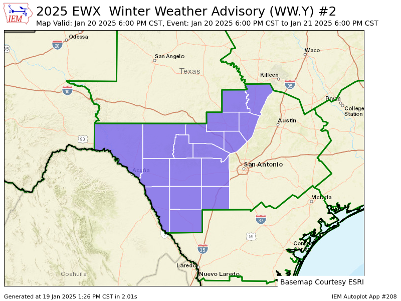
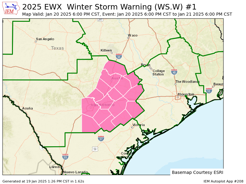
Good, detailed discussion this afternoon out of NWSFO Austin/San Antonio. Interesting portion of it:
First, we`d like to note some concerns regarding snow/sleet ratios
and snow shape/types. Model soundings continue to show across our
region, a dry layer aloft across the dendrite growth zone (-12 to -
18 degrees) for majority of the event. The models show better
moisture closer to or across the dendrite growth zone farther east
and as you get into the Houston CWA. Additionally, the ice
containing clouds will all trend mainly warmer than -10 degrees C
below 700 mb and would likely result in a concentration of some
supercooled liquid (water). This may help lead to ice riming on
the snow and/or sleet pellets that fall. The coldest temperatures
aloft that the flakes form also are in the favorable zone where
snowflake type may be more in the column/needle type than
plates/dendrites. These processes and sleet mixing in could lower
snow to liquid ratios. NBM seems to support these notions and
indicate ratios generally in the 4:1 to 8:1 level over most of the
region.
Now, let`s get down to the accumulations. This forecast calls for 1
to 2 inches of snow and sleet accumulation near the I-35 corridor
and points east with slightly higher totals up to 3 inches over
portions of Lee, Fayette and Lavaca counties. As indicated on some
of the guidance, for example the ECMWF, some isolated higher totals
will be possible with any mesoscale banding of heavier
precipitation. Elsewhere, up to an inch of snow will be possible.
Regarding ice accretion, around a tenth of an inch will be possible
across our southeastern most counties around DeWitt County with a
few hundredths of an inch otherwise for locations around or just
north of the I-10 corridor. Like with snow/sleet accumulation,
isolated totals are possible if temperatures fall faster or trend
colder or where mesoscale banding of any heavier precipitation
occurs.
Travel is expected to become difficult and inadvisable, especially
across elevated bridges and overpasses, as roads become slick and
hazardous. These travel impacts and with the latest forecast
accumulation amounts in mind, we will elect to upgrade portions of
the Winter Storm Watch to a Winter Storm Warning across the I-35
corridor and points east. A Winter Weather Advisory will also be
issued to buffer the Warning across the remainder of South-Central
Texas.
4 likes
Any forecasts under my name are to be taken with a grain of salt. Get your best forecasts from the National Weather Service and National Hurricane Center.
-
txtwister78
- Category 5
- Posts: 2142
- Joined: Wed Jan 30, 2019 12:56 pm
- Location: San Antonio
Re: Texas Winter 2024-2025
One thing to note is some models are really trending this further south with time as colder/drier air surges in from the north and the low gets pushed further off the coast. 3km NAM not all that impressed for example with QPF. HRRR more bullish but QPF drops off significantly north of SA and 30-40 miles north of I-10 further east. Something to watch in future runs despite being 24 hours or so away from things beginning. Possible to see some nudges back north but it's been a trend south today with moisture.


0 likes
Re: Texas Winter 2024-2025
Stratton23 wrote:18z HRRR looks really good, widespread 4-7 inches of snow for the majority of se texas and points east


0 likes
-
TeamPlayersBlue

- Category 5
- Posts: 3524
- Joined: Tue Feb 02, 2010 1:44 am
- Location: Denver/Applewood, CO
Re: Texas Winter 2024-2025
Ntxw wrote:That 1895 map a few days ago still looks good about now. Such a rare event like that down the coast, this will probably be this century's memorable event for you folks down there.
The setup looks very very similar, but the high pressure isnt as strong. I think thats the only difference.
0 likes
Personal Forecast Disclaimer:
The posts in this forum are NOT official forecast and should not be used as such. They are just the opinion of the poster and may or may not be backed by sound meteorological data. They are NOT endorsed by any professional institution or storm2k.org. For official information, please refer to the NHC and NWS products.
The posts in this forum are NOT official forecast and should not be used as such. They are just the opinion of the poster and may or may not be backed by sound meteorological data. They are NOT endorsed by any professional institution or storm2k.org. For official information, please refer to the NHC and NWS products.
-
Portastorm
- Storm2k Moderator
- Posts: 9954
- Age: 63
- Joined: Fri Jul 11, 2003 9:16 am
- Location: Round Rock, TX
- Contact:
Re: Texas Winter 2024-2025
txtwister78 wrote:One thing to note is some models are really trending this further south with time as colder/drier air surges in from the north and the low gets pushed further off the coast. 3km NAM not all that impressed for example with QPF. HRRR more bullish but QPF drops off significantly north of SA and 30-40 miles north of I-10 further east. Something to watch in future runs despite being 24 hours or so away from things beginning. Possible to see some nudges back north but it's been a trend south today with moisture.
https://images.weatherbell.com/model/nam-nest/tx/snow_24hr_kuchera/1737309600/1737489600-PXyFszhU8z0.png
https://images.weatherbell.com/model/hrrr/tx/total_precip_inch/1737309600/1737482400-5HN3RbLBOoc.png
Now that's NOT the kind of maps I want to see, txtwister78! Quite possible though. Have you looked at the other meso models to see how the trend compares?
0 likes
Any forecasts under my name are to be taken with a grain of salt. Get your best forecasts from the National Weather Service and National Hurricane Center.
-
Stratton23
- Category 5
- Posts: 3491
- Joined: Fri Jul 21, 2023 10:59 pm
- Location: Katy, Tx
Re: Texas Winter 2024-2025
I dont really buy the NAM that much, its by far the most suppressed of the short range guidance and really doesn’t have much moisture, id calling it a big outlier right now
1 likes
Re: Texas Winter 2024-2025
Stratton23 wrote:I dont really buy the NAM that much, its by far the most suppressed of the short range guidance and really doesn’t have much moisture, id calling it a big outlier right now
RDPS and Icon are running so we'll have some comparison and contrast in a few minutes.
1 likes
-
txtwister78
- Category 5
- Posts: 2142
- Joined: Wed Jan 30, 2019 12:56 pm
- Location: San Antonio
Re: Texas Winter 2024-2025
Portastorm wrote:txtwister78 wrote:One thing to note is some models are really trending this further south with time as colder/drier air surges in from the north and the low gets pushed further off the coast. 3km NAM not all that impressed for example with QPF. HRRR more bullish but QPF drops off significantly north of SA and 30-40 miles north of I-10 further east. Something to watch in future runs despite being 24 hours or so away from things beginning. Possible to see some nudges back north but it's been a trend south today with moisture.
https://images.weatherbell.com/model/nam-nest/tx/snow_24hr_kuchera/1737309600/1737489600-PXyFszhU8z0.png
https://images.weatherbell.com/model/hrrr/tx/total_precip_inch/1737309600/1737482400-5HN3RbLBOoc.png
Now that's NOT the kind of maps I want to see, txtwister78! Quite possible though. Have you looked at the other meso models to see how the trend compares?
WRF-NSSL was probably most bullish and further north with QPF/snow out of all meso models. ARW similar to NAM. RAP similar to HRRR. It's been a slow shift south however with most models with each run.
1 likes
-
Stratton23
- Category 5
- Posts: 3491
- Joined: Fri Jul 21, 2023 10:59 pm
- Location: Katy, Tx
-
txtwister78
- Category 5
- Posts: 2142
- Joined: Wed Jan 30, 2019 12:56 pm
- Location: San Antonio
Who is online
Users browsing this forum: South Texas Storms and 176 guests