It does look like everyone should finally get a steady/persistent rain tomorrow morning, albeit sub-severe with only embedded thunder at best.
Summer can't get here fast enough...
Texas Spring 2025
Moderator: S2k Moderators
Forum rules

The posts in this forum are NOT official forecast and should not be used as such. They are just the opinion of the poster and may or may not be backed by sound meteorological data. They are NOT endorsed by any professional institution or STORM2K.
Re: Texas Spring 2025
0 likes
Re: Texas Spring 2025
snownado wrote:It does look like everyone should finally get a steady/persistent rain tomorrow morning, albeit sub-severe with only embedded thunder at best.
Summer can't get here fast enough...
At this rate I’ll believe it when I see it wouldn’t be surprised if everything shifted north.
0 likes
Re: Texas Spring 2025
Gotwood wrote:snownado wrote:It does look like everyone should finally get a steady/persistent rain tomorrow morning, albeit sub-severe with only embedded thunder at best.
Summer can't get here fast enough...
At this rate I’ll believe it when I see it wouldn’t be surprised if everything shifted north.
Widespread rain is going to happen without question tomorrow morning, as we'll finally be under more favorable jet dynamics aloft (thus better forcing) with the trough ejecting eastward.
It's just that we'll have much less instability to work with, so it should be primarily of the stratiform variety.
All in all, still an upsetting event locally for DFW from a both a weather weenie & outdooor planning standpoint (considering how much hype there was about thunderstorm activity leading up to this and what was originally a warm forecast) and frankly one I'm beyond ready to put behind us.
1 likes
Re: Texas Spring 2025
snownado wrote:Gotwood wrote:snownado wrote:It does look like everyone should finally get a steady/persistent rain tomorrow morning, albeit sub-severe with only embedded thunder at best.
Summer can't get here fast enough...
At this rate I’ll believe it when I see it wouldn’t be surprised if everything shifted north.
Widespread rain is going to happen without question tomorrow morning, as we'll finally be under more favorable jet dynamics aloft (thus better forcing) with the trough ejecting eastward.
It's just that we'll have much less instability to work with, so it should be primarily of the stratiform variety.
All in all, still an upsetting event locally for DFW from a both a weather weenie & outdooor planning standpoint (considering how much hype there was about thunderstorm activity leading up to this and what was originally a warm forecast) and frankly one I'm beyond ready to put behind this.
Next week looks dry and pleasant. Comfortable April temps with nothing too hot.
2 likes
-
rwfromkansas
- Category 5

- Posts: 3019
- Joined: Sat Aug 27, 2005 12:47 am
- Location: North Fort Worth
Re: Texas Spring 2025
Another morning with a canceled severe thunderstorm watch. Lol.
Well, at least it APPEARS rain is likely tomorrow.
But, this event should really put some doubt in those severe analogs people love to post.
It really screwed most of Texas.
Well, at least it APPEARS rain is likely tomorrow.
But, this event should really put some doubt in those severe analogs people love to post.
It really screwed most of Texas.
0 likes
Re: Texas Spring 2025
This afternoon has a higher risk of supercell development in NE TX than previous days (hence the moderate risk extending into TX). Fairfield to Canton and points northeast from about 3 pm to 10 pm look to be under the gun. I don't know what the failure modes have been from previous days, but so far today there is still substantial cloud cover in the area. But there is a break currently in the aforementioned area along the front. And that's where storms should form this afternoon.
0 likes
-
Lagreeneyes03
- Category 2

- Posts: 609
- Joined: Mon Dec 09, 2013 10:53 am
- Location: Luxurious Lake Grapevine
Re: Texas Spring 2025
rwfromkansas wrote:Another morning with a canceled severe thunderstorm watch. Lol.
Well, at least it APPEARS rain is likely tomorrow.
But, this event should really put some doubt in those severe analogs people love to post.
It really screwed most of Texas.
It's been "the rain/storms will come tomorrow" for the past 4 days
0 likes
I'm a Princess, not a forecaster.
-
TomballEd
- Category 5
- Posts: 1260
- Age: 62
- Joined: Wed Aug 16, 2023 4:52 pm
- Location: Spring/Klein area, not Tomball
Re: Texas Spring 2025
Meso models showing a broken line of 'squeegee' showers and maybe a storm or two along the front tomorrow along and S of I-10. Houston and San Antonio won't get much more than half an inch, maybe less. A half an inch per week in spring is not how to build up soil moisture before the summer heat arrives. Early in the season to have a 76F morning low temperature. You'd think temps and dewpoints from May and June would mean rain.
OTOH, a little warmth beats the DFW area all day in the 50s weather. Although low in the 40s weather is coming for us down here for early Monday morning with highs only around 60F
OTOH, a little warmth beats the DFW area all day in the 50s weather. Although low in the 40s weather is coming for us down here for early Monday morning with highs only around 60F
1 likes
Re: Texas Spring 2025
The streamers are finally getting a little *OOMPH* to them, and just got my first crack of thunder for this entire event.
0 likes
-
txtwister78

- Category 5
- Posts: 2159
- Joined: Wed Jan 30, 2019 12:56 pm
- Location: San Antonio
Re: Texas Spring 2025
HRRR starting to pick up on the possibility of some storm development in the early evening hours across the 35 corridor from Austin into SA metro as mentioned yesterday. Definitely need to watch this trend as very large hail and perhaps even a spin up Tornado could be possible should this occur.
SPC did add San Antonio into the large hail risk threat outline (2 inch plus) in their last update.
SPC did add San Antonio into the large hail risk threat outline (2 inch plus) in their last update.
2 likes
-
Edwards Limestone

- S2K Supporter

- Posts: 504
- Age: 36
- Joined: Tue Dec 28, 2021 11:05 am
- Location: Smithson Valley, TX
Re: Texas Spring 2025
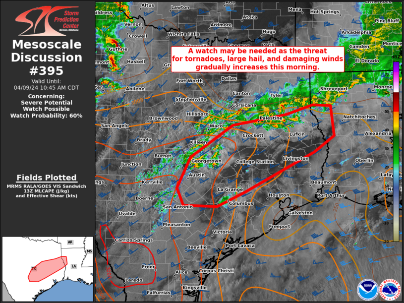
Mesoscale Discussion 0395
NWS Storm Prediction Center Norman OK
0126 PM CDT Fri Apr 04 2025
Areas affected...Parts of south-central into northeast TX
Concerning...Severe potential...Watch possible
Valid 041826Z - 042000Z
Probability of Watch Issuance...60 percent
SUMMARY...Strong to severe storms are possible this afternoon, with
a threat of large hail and strong to severe gusts. Some tornado
potential could also evolve with time.
DISCUSSION...Early this afternoon, a slow-moving cold front is
draped from northeast into south-central TX, with another weak cold
front/wind shift intersecting the primary front west of San Antonio
and extending southward toward Laredo. Elevated convection is
increasing to the cool side of the boundary across north-central TX,
with increasing showers noted across the warm sector noted across
east-central TX. Storm coverage is expected to increase with time on
either side of the front, as ascent gradually increases in response
to an approaching mid/upper-level trough.
Strong instability (with MLCAPE near/above 3000 J/kg along/east of
the front and similar MUCAPE magnitudes to the immediate cool side)
and around 50 kt of effective shear are providing a favorable
environment for organized convection, and maturing convection this
afternoon could evolve into a few supercells and/or organized
clusters, with a threat of large to very large hail and severe wind
gusts. The KGRK and KHGX VWPs depict a rather strong (35-45 kt)
low-level jet, and effective SRH will be sufficient to support some
tornado threat with any sustained warm-sector supercells.
Watch issuance will become increasingly possible this afternoon if
observational trends support development of multiple organized
storms across the region.
..Dean/Thompson.. 04/04/2025
...Please see www.spc.noaa.gov for graphic product...
ATTN...WFO...HGX...FWD...EWX...
LAT...LON 29699754 29929810 30269839 30649841 32309656 32499606
31999562 31549538 31179554 30629606 30199654 29839732
29699754
MOST PROBABLE PEAK TORNADO INTENSITY...100-130 MPH
MOST PROBABLE PEAK WIND GUST...55-70 MPH
MOST PROBABLE PEAK HAIL SIZE...2.00-3.50 IN
https://www.spc.noaa.gov/products/md/md0395.html
0 likes
The above post is NOT an official forecast and should not be used as such. It is just the opinion of the poster and may or may not be backed by sound meteorological data. It is NOT endorsed by any professional institution including Storm2k. For official information, please refer to NWS products.

-
mmmmsnouts
- Tropical Storm

- Posts: 213
- Joined: Tue Sep 05, 2023 10:04 pm
- Location: Arlington, TX
Re: Texas Spring 2025
rwfromkansas wrote:Another morning with a canceled severe thunderstorm watch. Lol.
Well, at least it APPEARS rain is likely tomorrow.
But, this event should really put some doubt in those severe analogs people love to post.
It really screwed most of Texas.
It won’t. They only post this stuff on social media for clout and attention. They don’t really care if it mega busts, they got what they wanted.
0 likes

-
HockeyTx82
- S2K Supporter
- Posts: 2782
- Joined: Tue Oct 27, 2009 11:17 am
- Location: Ponder, TX
Re: Texas Spring 2025
Winter Weather Advisories and Winter Storm Warnings in the Panhandle, while there is a Tornado Watch, including tornado warnings in East Texas.
Only in Texas, stay safe everyone!
https://www.weather.gov/
Only in Texas, stay safe everyone!
https://www.weather.gov/
2 likes
Don't hold me accountable for anything I post on this forum. Leave the real forecasting up to the professionals.
Location: Ponder, TX (all observation posts are this location unless otherwise noted)
Location: Ponder, TX (all observation posts are this location unless otherwise noted)
-
wxman22

- Category 5
- Posts: 1884
- Joined: Mon Jan 30, 2006 12:39 am
- Location: Wichita Falls, TX
- Contact:
Re: Texas Spring 2025
OUN finally pulled the trigger for Wichita Falls and added a 100% chance of rain/snow Saturday night and a 30% chance of all snow Sunday morning... Lets see if the 0z models continue the good trends seen today in the models.
This setup would be a major winter storm for North Texas and Oklahoma if it were happening a month or two ago.
This setup would be a major winter storm for North Texas and Oklahoma if it were happening a month or two ago.
1 likes
-
wxman22
- Category 5
- Posts: 1884
- Joined: Mon Jan 30, 2006 12:39 am
- Location: Wichita Falls, TX
- Contact:
Re: Texas Spring 2025
There were apparently 4 earthquakes today in west Texas in a span of 6 hours. I knew I wasn't going crazy this morning when I felt the ground shake slightly for a couple of seconds lol.
0 likes
-
jasons2k

- Storm2k Executive

- Posts: 8290
- Age: 52
- Joined: Wed Jul 06, 2005 12:32 pm
- Location: The Woodlands, TX
Re: Texas Spring 2025
Made it home safely. South of Corsicana, the pitch black sky turned turquoise and white in front of my as Apple Maps flashed "Severe Thunderstorm Warning Ahead." I was pretty concerned...
White knuckled with flashers for awhile, but I punched through with no hail, thank God. Phew! I saw a low base and rotation on the backside. Pretty sure I saw a couple chasers on the frontage road, too.
White knuckled with flashers for awhile, but I punched through with no hail, thank God. Phew! I saw a low base and rotation on the backside. Pretty sure I saw a couple chasers on the frontage road, too.
3 likes

Re: Texas Spring 2025
Watching the skies in hopes of initiation, likely right over the city if anything develops. Seeing thickening clouds and darkening underside just to the west of the city.
1 likes
Resident Rain Miser
I am a weather hobbyist living 3.5 miles south of Downtown Austin and in no way or fashion should anything I say concerning forecasts be taken seriously. Please check your local NWS for accurate weather forecasting and conditions.
I am a weather hobbyist living 3.5 miles south of Downtown Austin and in no way or fashion should anything I say concerning forecasts be taken seriously. Please check your local NWS for accurate weather forecasting and conditions.
-
txtwister78
- Category 5
- Posts: 2159
- Joined: Wed Jan 30, 2019 12:56 pm
- Location: San Antonio
Re: Texas Spring 2025
Few hi-res models still want to develop storms over the Austin/SA region between 7-8 PM tonight before the main event out west. Looks like a sea breeze boundary moving into SA metro. Need to see how this interacts with frontal boundary as this could be area to watch for development.


1 likes
Return to “USA & Caribbean Weather”
Who is online
Users browsing this forum: 869MB, cstrunk, SnowyOwl31, Stonewood Ranch, Tireman4 and 51 guests