I see we're back to the same crap we dealt with at the beginning of April with the persistent gloomy weather and high temp busts.
No way will the high of 87*F verify today, and I wouldn't be surprised if we stay stuck in the 60s through the weekend.
Texas Spring 2025
Moderator: S2k Moderators
Forum rules

The posts in this forum are NOT official forecast and should not be used as such. They are just the opinion of the poster and may or may not be backed by sound meteorological data. They are NOT endorsed by any professional institution or STORM2K.
Re: Texas Spring 2025
Last edited by snownado on Thu May 01, 2025 10:34 am, edited 1 time in total.
0 likes

Re: Texas Spring 2025
I'd take 60s down in College Station. Gloomy all summer to cut down on our ridiculous power bills! lol
2 likes


Re: Texas Spring 2025
Hope this continues through summer! 2007, 2013, 2014, 2021 please!
3 likes
The above post and any post by Ntxw is NOT an official forecast and should not be used as such. It is just the opinion of the poster and may or may not be backed by sound meteorological data. It is NOT endorsed by any professional institution including Storm2k. For official information, please refer to NWS products.
Help support Storm2K!
-
Edwards Limestone

- S2K Supporter

- Posts: 507
- Age: 36
- Joined: Tue Dec 28, 2021 11:05 am
- Location: Smithson Valley, TX
Re: Texas Spring 2025
TomballEd wrote:As is common around here, most of the Houston area missed significant rain yesterday and while 11Z HRRR shows a few strong storms well N of the Metro, nothing is immediate.
Pretty standard what looks like the promise of decent rains S of I-10 in Texas on the models evaporate as the events get closer. Even HRRR showed a decent, if weakening, line of storms through the HOU metro, which of course didn't materialize.
Yup, same here. HRRR now only shows rain for the Hill Country/Edwards Plateau tomorrow night w/ the frontal passage. A week of good rain chances turns into a one shot event lasting a few hours.
0 likes
The above post is NOT an official forecast and should not be used as such. It is just the opinion of the poster and may or may not be backed by sound meteorological data. It is NOT endorsed by any professional institution including Storm2k. For official information, please refer to NWS products.
-
HockeyTx82
- S2K Supporter
- Posts: 2782
- Joined: Tue Oct 27, 2009 11:17 am
- Location: Ponder, TX
Re: Texas Spring 2025
Anything suggesting long range that we're going to get into a very active severe pattern here in the North Texas area, or just good rain chances and low-end severe?
0 likes
Don't hold me accountable for anything I post on this forum. Leave the real forecasting up to the professionals.
Location: Ponder, TX (all observation posts are this location unless otherwise noted)
Location: Ponder, TX (all observation posts are this location unless otherwise noted)
Re: Texas Spring 2025
HockeyTx82 wrote:Anything suggesting long range that we're going to get into a very active severe pattern here in the North Texas area, or just good rain chances and low-end severe?
Nothing stands out, every system that produces rain can be a severe weather event if the timing, storm mode is right. But nothing is screaming outbreak on the horizon. Very heavy rain events for sure.
0 likes
The above post and any post by Ntxw is NOT an official forecast and should not be used as such. It is just the opinion of the poster and may or may not be backed by sound meteorological data. It is NOT endorsed by any professional institution including Storm2k. For official information, please refer to NWS products.
Help support Storm2K!
Help support Storm2K!
-
txtwister78

- Category 5

- Posts: 2162
- Joined: Wed Jan 30, 2019 12:56 pm
- Location: San Antonio
Re: Texas Spring 2025
SPC went with the upgrade with the significant hail designation as I suspected they would and so now we watch the radar later today for verification.
Got to stay patient and look at real-time data each day under a pattern like this before throwing in the towel regarding rain chances. Another chance tomorrow.
Got to stay patient and look at real-time data each day under a pattern like this before throwing in the towel regarding rain chances. Another chance tomorrow.
2 likes
-
TomballEd
- Category 5
- Posts: 1263
- Age: 62
- Joined: Wed Aug 16, 2023 4:52 pm
- Location: Spring/Klein area, not Tomball
Re: Texas Spring 2025
Nothing on radar but satellite shows some cu developing very near Austin. Or maybe something is on fire.
EDIT TO ADD
SPC RAP analysis shows 4500 J/Kg ML CAPE and less than (or greater than, depending) -25 J/Kg CINH.
EDIT TO ADD
SPC RAP analysis shows 4500 J/Kg ML CAPE and less than (or greater than, depending) -25 J/Kg CINH.
0 likes

Re: Texas Spring 2025
TomballEd wrote:As is common around here, most of the Houston area missed significant rain yesterday and while 11Z HRRR shows a few strong storms well N of the Metro, nothing is immediate.
Pretty standard what looks like the promise of decent rains S of I-10 in Texas on the models evaporate as the events get closer. Even HRRR showed a decent, if weakening, line of storms through the HOU metro, which of course didn't materialize.
I never expected much rain around our area this morning. Herzog was showing some model yesterday that had rain slowly moving south early this morning through our area, but I never believed that. I looked at many runs of the HRRR yesterday on Tidbitds and none of the runs I saw had much of anything S of I-10.
0 likes
-
TomballEd
- Category 5
- Posts: 1263
- Age: 62
- Joined: Wed Aug 16, 2023 4:52 pm
- Location: Spring/Klein area, not Tomball
Re: Texas Spring 2025
Cool looking gravity waves coming from opposite directions, converging in the general area of the hatched hail risk
0 likes
-
txtwister78
- Category 5
- Posts: 2162
- Joined: Wed Jan 30, 2019 12:56 pm
- Location: San Antonio
Re: Texas Spring 2025
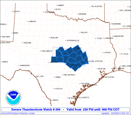
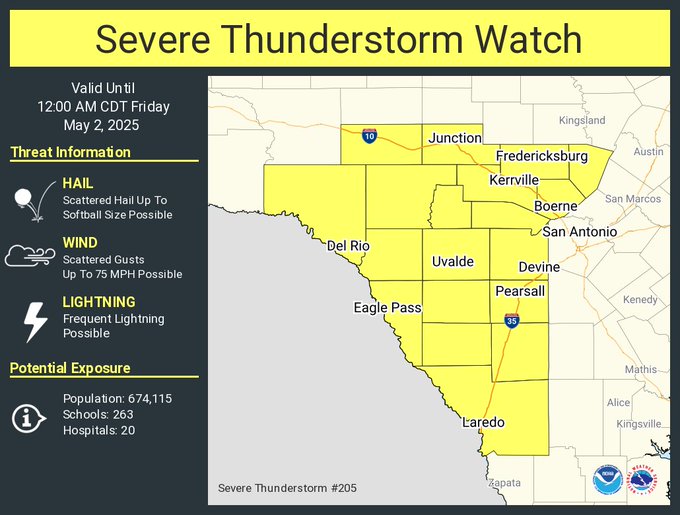
Two areas to monitor this afternoon into early evening across central and SC TX. Obviously first being where the Severe Thunderstorm Watch has been issued by SPC across the Austin metro.
The second location is west of SA across the southern Edwards Plateau region where storms are also beginning to fire just north of Uvalde.
With instability values around 5k or greater this afternoon, no doubt about why SPC has continued to expand the significant hail threat hatched area across the region.
1 likes
-
txtwister78
- Category 5
- Posts: 2162
- Joined: Wed Jan 30, 2019 12:56 pm
- Location: San Antonio


Re: Texas Spring 2025
txtwister78 wrote:Confirmed Tornado on the ground just SW of Killeen.
The HRRR had that storm nailed since yesterday. Crazy.
1 likes


-
txtwister78
- Category 5
- Posts: 2162
- Joined: Wed Jan 30, 2019 12:56 pm
- Location: San Antonio
-
wxman22

- Category 5
- Posts: 1887
- Joined: Mon Jan 30, 2006 12:39 am
- Location: Wichita Falls, TX
- Contact:
Re: Texas Spring 2025
441 PM CDT Thu May 1 2025
...A TORNADO WARNING REMAINS IN EFFECT UNTIL 500 PM CDT FOR
NORTHEASTERN BURNET COUNTY...
At 441 PM CDT, a confirmed large and extremely dangerous tornado was
located near Kempner, or 8 miles southwest of Copperas Cove, moving
southeast at 10 mph.
This is a PARTICULARLY DANGEROUS SITUATION. TAKE COVER NOW!
HAZARD...Damaging tornado.
SOURCE...Radar confirmed tornado.
IMPACT...You are in a life-threatening situation. Flying debris may
be deadly to those caught without shelter. Mobile homes
will be destroyed. Considerable damage to homes,
businesses, and vehicles is likely and complete destruction
is possible.
Locations impacted include...
Briggs.
PRECAUTIONARY/PREPAREDNESS ACTIONS...
To repeat, a large, extremely dangerous and potentially deadly
tornado is on the ground. To protect your life, TAKE COVER NOW! Move
to a basement or an interior room on the lowest floor of a sturdy
building. Avoid windows. If you are outdoors, in a mobile home, or in
a vehicle, move to the closest substantial shelter and protect
yourself from flying debris.
Motorists should not take shelter under highway overpasses. If you
cannot safely drive away from the tornado, as a last resort, either
park your vehicle and stay put, or abandon your vehicle and lie down
in a low lying area and protect yourself from flying debris.
0 likes
-
txtwister78
- Category 5
- Posts: 2162
- Joined: Wed Jan 30, 2019 12:56 pm
- Location: San Antonio
Re: Texas Spring 2025
Just like that, we went from "nothing on the HRRR" to a flash flood potential scenario courtesy of an outflow boundary, the dryline out west and some insane instability for storms to work with. Models don't always tell the full story real-time and so here we go folks. Possible this complex could make it into the SA metro later this evening per WPC.

1 likes
Return to “USA & Caribbean Weather”
Who is online
Users browsing this forum: Brent and 79 guests