Yeah if we get another Monday outbreak
Both the historic Moore tornadoes were on a Monday

Moderator: S2k Moderators


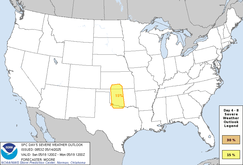
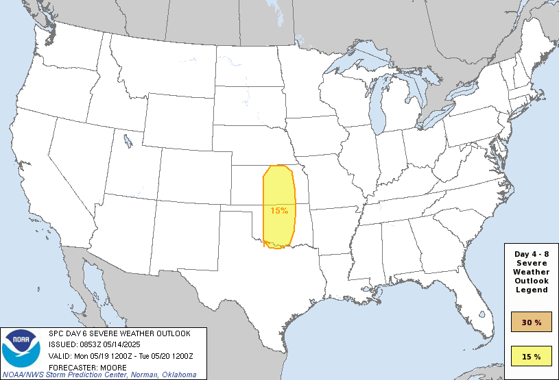
Day 4-8 Convective Outlook
NWS Storm Prediction Center Norman OK
0353 AM CDT Wed May 14 2025
Valid 171200Z - 221200Z
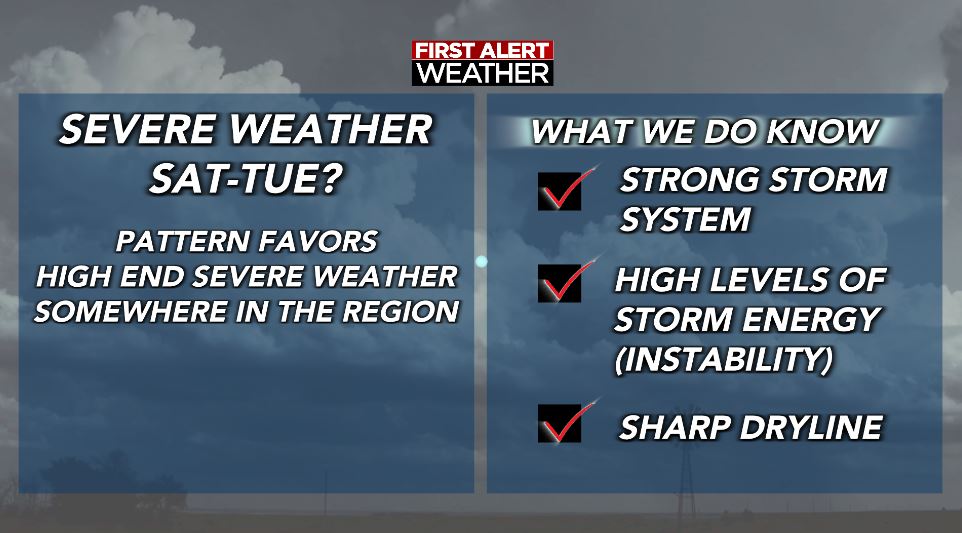
...DISCUSSION...
An active period of severe weather remains likely through the
weekend and into early next week for portions of the central CONUS.
A weakening upper trough is forecast to migrate across the Northeast
late this weekend as a second upper wave begins to amplify over the
western states. This upper regime will favor surface pressure falls
across the High Plains that will promote south/southeasterly return
flow into the southern/central Plains through early next week.
Severe thunderstorm chances will increase as preceding upper
disturbances and the primary upper wave eject into the Plains over
the warm sector. While severe weather chances are anticipated most
days through the extended period, confidence in more focused,
synoptically-driven corridors is currently greatest on D5/Sunday and
D6/Monday across the southern Plains.
...D5/Sunday to D6/Monday...
Increasing southwesterly flow aloft over the southern/central
Rockies will promote lee cyclogenesis across the central High Plains
beginning D4/Saturday through D7/Monday. This will foster moisture
return into northern TX, OK, and southern KS as a warm front lifts
north. Long-range ensemble guidance suggests dewpoints ranging from
the mid 60s to low 70s are likely by Sunday afternoon across the
southern High Plains to the east of a sharpening dryline. Recent
GFS/GEFS solutions have come into better alignment with ECMWF/EPS
runs that depict a leading impulse within the subtropical jet
overspreading the southern High Plains late Sunday afternoon.
Enhanced westerly low- to mid-level flow coupled with ascent
associated with the upper feature should promote eastward mixing of
the dryline with attendant chances for thunderstorm development
within a buoyant and strongly sheared environment.
The ejection of the primary trough axis on D6/Monday should result
in more widespread 50+ knot mid-level flow overspreading much of
OK/KS. The eastward migration of the surface low and trailing
dryline through the day should provide adequate forcing for ascent
for thunderstorm development within a buoyant and strongly sheared
environment, which should promote an organized, and potentially more
widespread, severe threat.
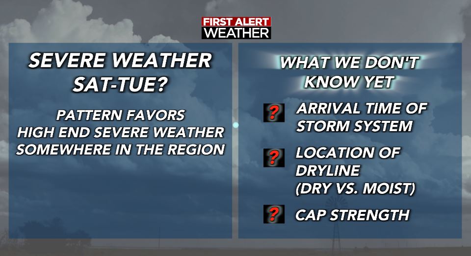
More specific mesoscale details for both days remain unclear at this
range, but the general alignment of global deterministic/ensemble
guidance regarding the overall synoptic regime and convective
environment, combined with a consistent QPF signal on both days,
suggests predictability is high enough to introduce risk
probabilities.

rwfromkansas wrote:My home station literally peaked at 99.9. Not joking. It's down to 97.5, so I think we may avoid the first 100 IMBY.
That is crazy how close it got.
Cpv17 wrote:rwfromkansas wrote:My home station literally peaked at 99.9. Not joking. It's down to 97.5, so I think we may avoid the first 100 IMBY.
That is crazy how close it got.
Weird it peaked that early in the day.
rwfromkansas wrote:Cpv17 wrote:rwfromkansas wrote:My home station literally peaked at 99.9. Not joking. It's down to 97.5, so I think we may avoid the first 100 IMBY.
That is crazy how close it got.
Weird it peaked that early in the day.
Yeah, usually it's at 3-4 or so, so kind of strange. It is going back up again a little, so hopefully it stays below 100.
Ntxw wrote:Cloud cover and higher dewpoints have kept temperatures from soaring today. Still hot, but not as high they were looking to be.
https://i.imgur.com/ZLPSFM8.png


DallasAg wrote:Ntxw wrote:Cloud cover and higher dewpoints have kept temperatures from soaring today. Still hot, but not as high they were looking to be.
https://i.imgur.com/ZLPSFM8.png
DFW even managed to avoid the record high for the date. Topped out at 94. Once the wind kicked back around to the south (from SW) and the dewpoints climbed it pretty much halted the temps.

South Texas Storms wrote:DallasAg wrote:Ntxw wrote:Cloud cover and higher dewpoints have kept temperatures from soaring today. Still hot, but not as high they were looking to be.
https://i.imgur.com/ZLPSFM8.png
DFW even managed to avoid the record high for the date. Topped out at 94. Once the wind kicked back around to the south (from SW) and the dewpoints climbed it pretty much halted the temps.
Congrats to us for only reaching the mid 90s to lower 100s today. In mid May...typically one of the wettest times of the year. This pattern sucks.
cstrunk wrote:The 95/96F forecast high for Longview busted. 89F was the max.


Stratton23 wrote:Some signs that the heat ridge may try to retrogade back to the west and setup over the western US, that may take the worst of the heat away from texas, noaa still calls for above average precipitation across the state, i just dont buy it, im not really optimistic we are going to be seeing any decent rain chances even going into the longer range
 May all time record is 77 apparently
 Return to “USA & Caribbean Weather”
Users browsing this forum: Brent and 131 guests


