https://tropic.ssec.wisc.edu/real-time/sal/salmain.php?&prod=split&time=
2025 Global Model Runs Discussion (Out thru day 16)
Moderator: S2k Moderators
Forum rules

The posts in this forum are NOT official forecasts and should not be used as such. They are just the opinion of the poster and may or may not be backed by sound meteorological data. They are NOT endorsed by any professional institution or STORM2K. For official information, please refer to products from the National Hurricane Center and National Weather Service.
-
tropicwatch

- Category 5

- Posts: 3426
- Age: 62
- Joined: Sat Jun 02, 2007 10:01 am
- Location: The Villages, Florida
- Contact:
Re: 2025 Global Model Runs Discussion (Out thru day 16)
Looks like anything coming off of Africa will be death by dust 
https://tropic.ssec.wisc.edu/real-time/sal/salmain.php?&prod=split&time=
https://tropic.ssec.wisc.edu/real-time/sal/salmain.php?&prod=split&time=
0 likes
Tropicwatch
Agnes 72', Eloise 75, Elena 85', Kate 85', Charley 86', Florence 88', Beryl 94', Dean 95', Erin 95', Opal 95', Earl 98', Georges 98', Ivan 2004', Arlene 2005', Dennis 2005', Ida 2009' Debby 2012' Irma 2017' Michael 2018'
Agnes 72', Eloise 75, Elena 85', Kate 85', Charley 86', Florence 88', Beryl 94', Dean 95', Erin 95', Opal 95', Earl 98', Georges 98', Ivan 2004', Arlene 2005', Dennis 2005', Ida 2009' Debby 2012' Irma 2017' Michael 2018'
-
TomballEd
- Category 5
- Posts: 1292
- Age: 62
- Joined: Wed Aug 16, 2023 4:52 pm
- Location: Spring/Klein area, not Tomball
Re: 2025 Global Model Runs Discussion (Out thru day 16)
cycloneye wrote:At least there is something to watch at very long range if 12z Euro is right. This wave is behind the other one that models are having back and forth.
https://i.imgur.com/CtgAnjm.png
Just because of the time frame involved I'm not giving up with model support like this from ECENs. Some die via The Graveyard or Hispaniola but at least 20% make it through, and a couple of those graze the Bahamas. I need another 0/12Z run or two before I say next on that one. Weekly Euro week on the early wave very tepid, a tiny area of >5% between well E of the Caribbean, a 5 and 10% named storm probs on the 360 hr Op Euro storm approaching the Bahamas.

1 likes
-
Stratton23
- Category 5
- Posts: 3558
- Joined: Fri Jul 21, 2023 10:59 pm
- Location: Katy, Tx
Re: 2025 Global Model Runs Discussion (Out thru day 16)
tropicwatch eh not necessarily, if waves come off at a low enough latitude, they can avoid getting entrenched by the dust
0 likes
-
tropicwatch
- Category 5
- Posts: 3426
- Age: 62
- Joined: Sat Jun 02, 2007 10:01 am
- Location: The Villages, Florida
- Contact:
Re: 2025 Global Model Runs Discussion (Out thru day 16)
Stratton23 wrote:tropicwatch eh not necessarily, if waves come off at a low enough latitude, they can avoid getting entrenched by the dust
Looks like the dust is currently south of 10 too.
0 likes
Tropicwatch
Agnes 72', Eloise 75, Elena 85', Kate 85', Charley 86', Florence 88', Beryl 94', Dean 95', Erin 95', Opal 95', Earl 98', Georges 98', Ivan 2004', Arlene 2005', Dennis 2005', Ida 2009' Debby 2012' Irma 2017' Michael 2018'
Agnes 72', Eloise 75, Elena 85', Kate 85', Charley 86', Florence 88', Beryl 94', Dean 95', Erin 95', Opal 95', Earl 98', Georges 98', Ivan 2004', Arlene 2005', Dennis 2005', Ida 2009' Debby 2012' Irma 2017' Michael 2018'
Re: 2025 Global Model Runs Discussion (Out thru day 16)
StormWeather wrote:LarryWx wrote:mStormWeather wrote:Just want to know, how often is the EURO right?
Euro Weeklies last yr did pretty well from a few weeks out when it was consistent over many runs in a row. So, we’ll need to see if this e-cards activity hold up in future runs.
What is 140% of the 2005-2024 Avg for the time of Aug 18-24 anyway?
Today’s Euro Weeklies maintained an active Aug 18-24 with ~145% of 2005-24. That translates to ~13 of ACE being progged vs base of ~9. Should that week have ~13, that would imply the likelihood of an H somewhere in the basin.
Where does this run imply would be the most likely general location of the track of this H? All highly speculative obviously but fwiw it suggests track may be from at or just N of N Leewards NW to near Bermuda or west of there between Bermuda and NC and then recurving to between Cape Cod and 1000 miles E of there aiming toward Newfoundland.
Midpoint of highest density of tracks starts at 20N, 60W. Then track points NW to 30N, 70W. Then NNE to 40N, 65W. Highest at risk from this prog ~Bermuda.
1 likes
Personal Forecast Disclaimer:
The posts in this forum are NOT official forecasts and should not be used as such. They are just the opinion of the poster and may or may not be backed by sound meteorological data. They are NOT endorsed by any professional institution or storm2k.org. For official information, please refer to the NHC and NWS products.
The posts in this forum are NOT official forecasts and should not be used as such. They are just the opinion of the poster and may or may not be backed by sound meteorological data. They are NOT endorsed by any professional institution or storm2k.org. For official information, please refer to the NHC and NWS products.
-
StormWeather

- Category 1

- Posts: 476
- Joined: Wed Jun 05, 2024 2:34 pm
Re: 2025 Global Model Runs Discussion (Out thru day 16)
LarryWx wrote:StormWeather wrote:LarryWx wrote:m
Euro Weeklies last yr did pretty well from a few weeks out when it was consistent over many runs in a row. So, we’ll need to see if this e-cards activity hold up in future runs.
What is 140% of the 2005-2024 Avg for the time of Aug 18-24 anyway?
Today’s Euro Weeklies maintained an active Aug 18-24 with ~145% of 2005-24. That translates to ~13 of ACE being progged vs base of ~9. Should that week have ~13, that would imply the likelihood of an H somewhere in the basin.
Where does this run imply would be the most likely general location of the track of this H? All highly speculative obviously but fwiw it suggests track may be from at or just N of N Leewards NW to near Bermuda or west of there between Bermuda and NC and then recurving to between Cape Cod and 1000 miles E of there aiming toward Newfoundland.
Midpoint of highest density of tracks starts at 20N, 60W. Then track points NW to 30N, 70W. Then NNE to 40N, 65W. Highest at risk from this prog ~Bermuda.
It seems to me that it keeps up trending each day. I currently don’t have access to the Euro charts, can you share screenshots?
0 likes
Just an average cyclone tracker
The posts in this forum are NOT official forecasts and should not be used as such. They are just the opinion of the poster and may or may not be backed by sound meteorological data. They are NOT endorsed by any professional institution or storm2k.org. For official information, please refer to the NHC and NWS products
The posts in this forum are NOT official forecasts and should not be used as such. They are just the opinion of the poster and may or may not be backed by sound meteorological data. They are NOT endorsed by any professional institution or storm2k.org. For official information, please refer to the NHC and NWS products
Re: 2025 Global Model Runs Discussion (Out thru day 16)
StormWeather wrote:LarryWx wrote:StormWeather wrote:What is 140% of the 2005-2024 Avg for the time of Aug 18-24 anyway?
Today’s Euro Weeklies maintained an active Aug 18-24 with ~145% of 2005-24. That translates to ~13 of ACE being progged vs base of ~9. Should that week have ~13, that would imply the likelihood of an H somewhere in the basin.
Where does this run imply would be the most likely general location of the track of this H? All highly speculative obviously but fwiw it suggests track may be from at or just N of N Leewards NW to near Bermuda or west of there between Bermuda and NC and then recurving to between Cape Cod and 1000 miles E of there aiming toward Newfoundland.
Midpoint of highest density of tracks starts at 20N, 60W. Then track points NW to 30N, 70W. Then NNE to 40N, 65W. Highest at risk from this prog ~Bermuda.
It seems to me that it keeps up trending each day. I currently don’t have access to the Euro charts, can you share screenshots?
Sorry but I can’t. All I can do is describe.
1 likes
Personal Forecast Disclaimer:
The posts in this forum are NOT official forecasts and should not be used as such. They are just the opinion of the poster and may or may not be backed by sound meteorological data. They are NOT endorsed by any professional institution or storm2k.org. For official information, please refer to the NHC and NWS products.
The posts in this forum are NOT official forecasts and should not be used as such. They are just the opinion of the poster and may or may not be backed by sound meteorological data. They are NOT endorsed by any professional institution or storm2k.org. For official information, please refer to the NHC and NWS products.
Re: 2025 Global Model Runs Discussion (Out thru day 16)
StormWeather wrote:LarryWx wrote:StormWeather wrote:What is 140% of the 2005-2024 Avg for the time of Aug 18-24 anyway?
Today’s Euro Weeklies maintained an active Aug 18-24 with ~145% of 2005-24. That translates to ~13 of ACE being progged vs base of ~9. Should that week have ~13, that would imply the likelihood of an H somewhere in the basin.
Where does this run imply would be the most likely general location of the track of this H? All highly speculative obviously but fwiw it suggests track may be from at or just N of N Leewards NW to near Bermuda or west of there between Bermuda and NC and then recurving to between Cape Cod and 1000 miles E of there aiming toward Newfoundland.
Midpoint of highest density of tracks starts at 20N, 60W. Then track points NW to 30N, 70W. Then NNE to 40N, 65W. Highest at risk from this prog ~Bermuda.
It seems to me that it keeps up trending each day. I currently don’t have access to the Euro charts, can you share screenshots?
Try this link:
https://charts.ecmwf.int/products/mofc_ ... 2508250000
1 likes
Personal Forecast Disclaimer:
The posts in this forum are NOT official forecasts and should not be used as such. They are just the opinion of the poster and may or may not be backed by sound meteorological data. They are NOT endorsed by any professional institution or storm2k.org. For official information, please refer to the NHC and NWS products.
The posts in this forum are NOT official forecasts and should not be used as such. They are just the opinion of the poster and may or may not be backed by sound meteorological data. They are NOT endorsed by any professional institution or storm2k.org. For official information, please refer to the NHC and NWS products.
-
StormWeather
- Category 1
- Posts: 476
- Joined: Wed Jun 05, 2024 2:34 pm
Re: 2025 Global Model Runs Discussion (Out thru day 16)
LarryWx wrote:StormWeather wrote:LarryWx wrote:
Today’s Euro Weeklies maintained an active Aug 18-24 with ~145% of 2005-24. That translates to ~13 of ACE being progged vs base of ~9. Should that week have ~13, that would imply the likelihood of an H somewhere in the basin.
Where does this run imply would be the most likely general location of the track of this H? All highly speculative obviously but fwiw it suggests track may be from at or just N of N Leewards NW to near Bermuda or west of there between Bermuda and NC and then recurving to between Cape Cod and 1000 miles E of there aiming toward Newfoundland.
Midpoint of highest density of tracks starts at 20N, 60W. Then track points NW to 30N, 70W. Then NNE to 40N, 65W. Highest at risk from this prog ~Bermuda.
It seems to me that it keeps up trending each day. I currently don’t have access to the Euro charts, can you share screenshots?
Try this link:
https://charts.ecmwf.int/products/mofc_ ... 2508250000
I can see it now. Yea the chances are in the low range now, but I can see the recurving signal.
1 likes
Just an average cyclone tracker
The posts in this forum are NOT official forecasts and should not be used as such. They are just the opinion of the poster and may or may not be backed by sound meteorological data. They are NOT endorsed by any professional institution or storm2k.org. For official information, please refer to the NHC and NWS products
The posts in this forum are NOT official forecasts and should not be used as such. They are just the opinion of the poster and may or may not be backed by sound meteorological data. They are NOT endorsed by any professional institution or storm2k.org. For official information, please refer to the NHC and NWS products
Re: 2025 Global Model Runs Discussion (Out thru day 16)
Only things to watch on the models right now are the wave that'll be approaching the islands next week (little no development until past the Islands, if at all ever) The google model shows a few hurricanes from that one (see This link ) , including NC and Gulf hits in roughly 2 weeks. So it'll be interesting to check how that newer model does down the line, the Euro ensembles aren't really latching on to any significant development (some development). GFS doesn't do anything with the wave. Icon and euro AI do more with it, but nothing too crazy on intensity. Euro AI does continue to taunt south Florida though.
Much more likely -- but still not anywhere close to definite, however is something home brew getting off the Carolina coast -- some of it could be traced back to 93L on vort charts, and then moving out to sea (Generally avoiding Bermuda).
Early August style of a few barking dogs, but probably no bites. Some really good tests for the newer AI based models, for genesis anyway (Genesis vs tracking actual cyclones is different) since other than a few ensemble members and maybe the Icon, are the only thing developing something out of the MDR. I guess the danger is the MDR wave becomes a late bloomer.
Last edited by BobHarlem on Sun Jul 27, 2025 10:42 am, edited 4 times in total.
0 likes
-
Hypercane_Kyle

- Category 5
- Posts: 3465
- Joined: Sat Mar 07, 2015 7:58 pm
- Location: Cape Canaveral, FL
Re: 2025 Global Model Runs Discussion (Out thru day 16)
I'll give the AI-based Euro and A for consistency, it'll probably get an "F" for accuracy though.
1 likes
My posts are my own personal opinion, defer to the National Hurricane Center (NHC) and other NOAA products for decision making during hurricane season.
-
Stratton23
- Category 5
- Posts: 3558
- Joined: Fri Jul 21, 2023 10:59 pm
- Location: Katy, Tx
Re: 2025 Global Model Runs Discussion (Out thru day 16)
Cant dismiss this wave coming off of africa yet, the 12z CMC trended back to some sort of development after prior runs showed nothing at all, weak low pressure developing near the southern bahamas, looks like it tries to head west across southern florida and into the gulf as a large heat done expands across the US
1 likes
-
WeatherBoy2000
- Category 1
- Posts: 461
- Joined: Mon Apr 10, 2023 9:29 am
Re: 2025 Global Model Runs Discussion (Out thru day 16)
Stratton23 wrote:Cant dismiss this wave coming off of africa yet, the 12z CMC trended back to some sort of development after prior runs showed nothing at all, weak low pressure developing near the southern bahamas, looks like it tries to head west across southern florida and into the gulf as a large heat done expands across the US
Even if this doesn't form, there's a chance we may see something spin up from a trough, like what the gfs is showing.
0 likes
-
cycloneye

- Admin

- Posts: 149462
- Age: 69
- Joined: Thu Oct 10, 2002 10:54 am
- Location: San Juan, Puerto Rico
Re: 2025 Global Model Runs Discussion (Out thru day 16)
12z EURO develops wave at long range and NOT the one that will emerge Africa shortly.

0 likes
Visit the Caribbean-Central America Weather Thread where you can find at first post web cams,radars
and observations from Caribbean basin members Click Here
and observations from Caribbean basin members Click Here
-
Blown Away

- S2K Supporter

- Posts: 10253
- Joined: Wed May 26, 2004 6:17 am
Re: 2025 Global Model Runs Discussion (Out thru day 16)
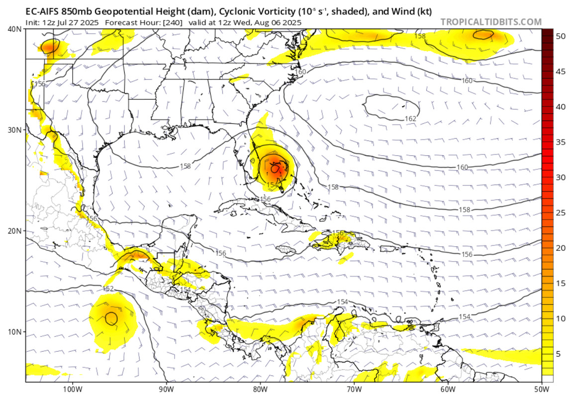
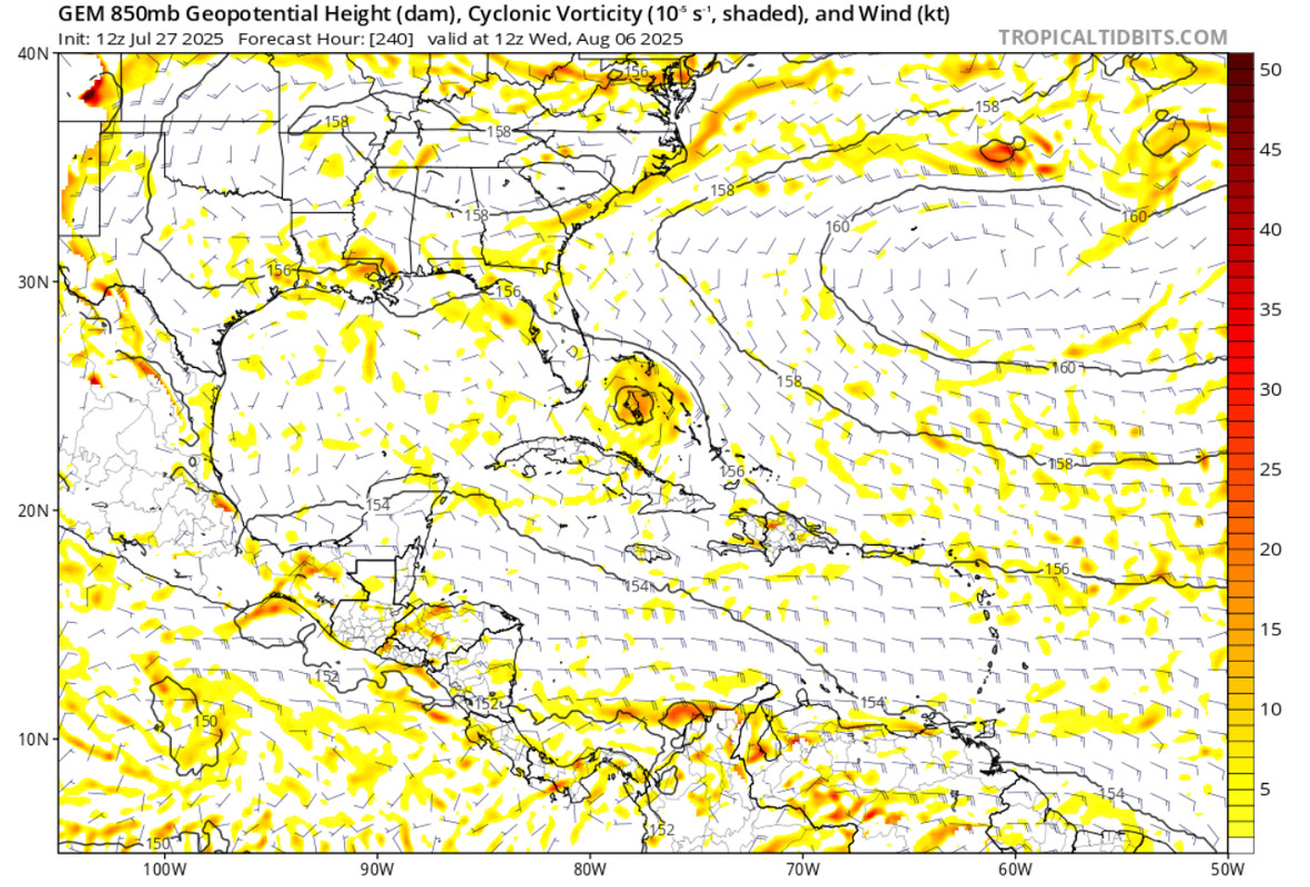
12z EC-AIFS
12z Canadian
Both models in agreement of a TD/TS near Bahamas/FL in the long range.
2 likes
Hurricane Eye Experience: David 79, Irene 99, Frances 04, Jeanne 04, Wilma 05… Hurricane Brush Experience: Andrew 92, Erin 95, Floyd 99, Matthew 16, Irma 17, Ian 22, Nicole 22…
Re: 2025 Global Model Runs Discussion (Out thru day 16)
12z Euro ai (Again) going with the late bloomer into S. Florida (And eventually LA) Regular Euro operational shreds it to pieces before the Bahamas.
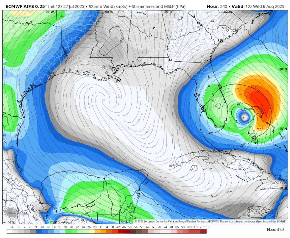
Canadian and Euro AI show something, the rest don't. GFS ensembles nada, Euro Ensembles curve it before the Bahamas. It'll be interesting to see which flavors. Icon puts it into Hispaniola. Going to be interesting to watch to see if the CMC/AIs bend away or if the rest bend toward that. (Safe bet AI gives up on this idea later, but the euro AI's been consistent for several runs now on the general idea).
Conversely the GFS shows activity off the Carolinas (including a system that goes over Bermuda) but the rest keep that area all stretched out.
1 likes
Re: 2025 Global Model Runs Discussion (Out thru day 16)
The new Euro Weeklies have a notable increase in forecasted activity for Aug 4-10, two weeks earlier than my post from yesterday addresses and consistent with the posts immediately above this:
https://charts.ecmwf.int/products/mofc_ ... 2508110000
https://charts.ecmwf.int/products/mofc_ ... 2508110000
https://charts.ecmwf.int/products/mofc_ ... 2508110000
https://charts.ecmwf.int/products/mofc_ ... 2508110000
1 likes
Personal Forecast Disclaimer:
The posts in this forum are NOT official forecasts and should not be used as such. They are just the opinion of the poster and may or may not be backed by sound meteorological data. They are NOT endorsed by any professional institution or storm2k.org. For official information, please refer to the NHC and NWS products.
The posts in this forum are NOT official forecasts and should not be used as such. They are just the opinion of the poster and may or may not be backed by sound meteorological data. They are NOT endorsed by any professional institution or storm2k.org. For official information, please refer to the NHC and NWS products.

Re: 2025 Global Model Runs Discussion (Out thru day 16)
BobHarlem wrote:12z Euro ai (Again) going with the late bloomer into S. Florida (And eventually LA) Regular Euro operational shreds it to pieces before the Bahamas.
https://i.postimg.cc/h43wd0y7/image0-1.gif
Canadian and Euro AI show something, the rest don't. GFS ensembles nada, Euro Ensembles curve it before the Bahamas. It'll be interesting to see which flavors. Icon puts it into Hispaniola. Going to be interesting to watch to see if the CMC/AIs bend away or if the rest bend toward that. (Safe bet AI gives up on this idea later, but the euro AI's been consistent for several runs now on the general idea).
Conversely the GFS shows activity off the Carolinas (including a system that goes over Bermuda) but the rest keep that area all stretched out.
https://i.imgur.com/OIExap2.png
While the GFS leans contrary to other models, keep in mind that the shown graphic is only at 180 hrs. I am especially concerned with any subtropical mischief just north of the greater Antilles given the death ridge pattern that seems to favor SE CONUS and Atlantic Seaboard.
1 likes
Andy D
(For official information, please refer to the NHC and NWS products.)
(For official information, please refer to the NHC and NWS products.)
Re: 2025 Global Model Runs Discussion (Out thru day 16)
BobHarlem wrote:12z Euro ai (Again) going with the late bloomer into S. Florida (And eventually LA) Regular Euro operational shreds it to pieces before the Bahamas.
https://i.postimg.cc/h43wd0y7/image0-1.gif
Canadian and Euro AI show something, the rest don't. GFS ensembles nada, Euro Ensembles curve it before the Bahamas. It'll be interesting to see which flavors. Icon puts it into Hispaniola. Going to be interesting to watch to see if the CMC/AIs bend away or if the rest bend toward that. (Safe bet AI gives up on this idea later, but the euro AI's been consistent for several runs now on the general idea).
Conversely the GFS shows activity off the Carolinas (including a system that goes over Bermuda) but the rest keep that area all stretched out.
https://i.imgur.com/OIExap2.png
This looks like a Katrina redux.
3 likes
-
OuterBanker
- S2K Supporter
- Posts: 1761
- Joined: Wed Feb 26, 2003 10:53 am
- Location: Nags Head, NC
- Contact:
Re: 2025 Global Model Runs Discussion (Out thru day 16)
BobHarlem wrote:12z Euro ai (Again) going with the late bloomer into S. Florida (And eventually LA) Regular Euro operational shreds it to pieces before the Bahamas.
https://i.postimg.cc/h43wd0y7/image0-1.gif
Canadian and Euro AI show something, the rest don't. GFS ensembles nada, Euro Ensembles curve it before the Bahamas. It'll be interesting to see which flavors. Icon puts it into Hispaniola. Going to be interesting to watch to see if the CMC/AIs bend away or if the rest bend toward that. (Safe bet AI gives up on this idea later, but the euro AI's been consistent for several runs now on the general idea).
Conversely the GFS shows activity off the Carolinas (including a system that goes over Bermuda) but the rest keep that area all stretched out.
https://i.imgur.com/OIExap2.png
Poor, poor NOLA.
Picked on by early season GFS ghosts also.
They don't seem to get a break (at least it's not us).
0 likes
Who is online
Users browsing this forum: hcane27 and 262 guests