
 Prior to now, I have been feeling fairly confident that our present "background state" would not evolve quickly enough to present a suddenly favorable "foreground state". Ah yes, but here we are once again. Facing that proverbial light-switch or ringing of the bell. Last year proved that climatology alone does not dictate the event. With the broad spread of models seemingly waking from their long slumber, common sense suggests that the sleeping bear is about to waken. Whether that amounts to one or two additional moderate to strong tropical storms by mid-month, or seeing our 1st hurricane to develop for the year, this remains to be seen. It is however these subtle shifts in each new days' model ensemble & operational forecasts that fascinate me so much. Guaging the change and the speed (timing) in which the various models increase or back off forecasted areas of development as well as change in their forecast intensities. It's easy to get caught up in the noise regarding any one specific model forecasting Armageddon somewhere, or about individual model track recurve tendencies. Looks to me like we've finally arrived to a point in this season where models start providing hints of changing conditions within certain areas of the basin. That was not the case last year at this time.
2025 Global Model Runs Discussion (Out thru day 16)
Moderator: S2k Moderators
Forum rules

The posts in this forum are NOT official forecasts and should not be used as such. They are just the opinion of the poster and may or may not be backed by sound meteorological data. They are NOT endorsed by any professional institution or STORM2K. For official information, please refer to products from the National Hurricane Center and National Weather Service.
Re: 2025 Global Model Runs Discussion (Out thru day 16)
I am beginning to question my decision to pass on purchasing trip insurance for my upcoming Bahamas cruise, approx. 2 weeks from now Prior to now, I have been feeling fairly confident that our present "background state" would not evolve quickly enough to present a suddenly favorable "foreground state". Ah yes, but here we are once again. Facing that proverbial light-switch or ringing of the bell. Last year proved that climatology alone does not dictate the event. With the broad spread of models seemingly waking from their long slumber, common sense suggests that the sleeping bear is about to waken. Whether that amounts to one or two additional moderate to strong tropical storms by mid-month, or seeing our 1st hurricane to develop for the year, this remains to be seen. It is however these subtle shifts in each new days' model ensemble & operational forecasts that fascinate me so much. Guaging the change and the speed (timing) in which the various models increase or back off forecasted areas of development as well as change in their forecast intensities. It's easy to get caught up in the noise regarding any one specific model forecasting Armageddon somewhere, or about individual model track recurve tendencies. Looks to me like we've finally arrived to a point in this season where models start providing hints of changing conditions within certain areas of the basin. That was not the case last year at this time.
Prior to now, I have been feeling fairly confident that our present "background state" would not evolve quickly enough to present a suddenly favorable "foreground state". Ah yes, but here we are once again. Facing that proverbial light-switch or ringing of the bell. Last year proved that climatology alone does not dictate the event. With the broad spread of models seemingly waking from their long slumber, common sense suggests that the sleeping bear is about to waken. Whether that amounts to one or two additional moderate to strong tropical storms by mid-month, or seeing our 1st hurricane to develop for the year, this remains to be seen. It is however these subtle shifts in each new days' model ensemble & operational forecasts that fascinate me so much. Guaging the change and the speed (timing) in which the various models increase or back off forecasted areas of development as well as change in their forecast intensities. It's easy to get caught up in the noise regarding any one specific model forecasting Armageddon somewhere, or about individual model track recurve tendencies. Looks to me like we've finally arrived to a point in this season where models start providing hints of changing conditions within certain areas of the basin. That was not the case last year at this time.
1 likes
Andy D
(For official information, please refer to the NHC and NWS products.)
(For official information, please refer to the NHC and NWS products.)
Re: 2025 Global Model Runs Discussion (Out thru day 16)
Still nothing consistent on the operational globals, but the 0z Euro shows a hurricane dangerously close to Bermuda on the 13th, and another system in the Caribbean forming shortly after. The Euro AI is back to putting a hurricane into south Florida on the 15th and into the Gulf/Mississippi. (Just a week later than the last time it was doing that -- It's going to get reputation for doing so) Long range is just wildly.
Most of the models are having a difficult time on what to do with the energy off the Carolinas also. (including GFS)
Although it does appear late august is more likely for a us landfall than usual if something actually develops, the longer range has been lacking any consistency on most of the models for any particular system. I'd be concerned if anything actually persisted for more than 24 hours or had multiple models going for it. (Ensembles are having the same issue)
Highlights (Again no consistancy):
0z Euro showing something near Bermuda:

0z Euro showing this in the West Caribbean

0z Euro AI wanting South Florida... again:

0z Euro AI then heading to Mississippi

Not shown:
The general confusion on what to do with the area off the Carolinas by GFS/UK/CMC and Euro.
GFS and CMC don''t show anything close to what the euros do, although there's a few ensembles on them, just not enough to take seriously. The ensembles showcases uncertainty with the stuff of the Carolinas more than anything else.
Euro ensembles are more a concern later, but the mismatch against the GFS ones in the MDR makes it not specific enough to pinpoint anything. (Euro does a few things off the Carolinas too, but the operational models don't seem to like it)
One thing I picked up on though, we definitely have a potential for multiple storms going at once around 2 1/2 - 3 weeks into August, just difficult to say where at.
6z GFS shows this too kinda. Gulf area for the wave NE of the Caribbean, area off Southeast, area north of Bermuda, and a bigger one well east into the Atlantic all at once. Subtle hints things just may suddenly pick up.

Most of the models are having a difficult time on what to do with the energy off the Carolinas also. (including GFS)
Although it does appear late august is more likely for a us landfall than usual if something actually develops, the longer range has been lacking any consistency on most of the models for any particular system. I'd be concerned if anything actually persisted for more than 24 hours or had multiple models going for it. (Ensembles are having the same issue)
Highlights (Again no consistancy):
0z Euro showing something near Bermuda:
0z Euro showing this in the West Caribbean
0z Euro AI wanting South Florida... again:
0z Euro AI then heading to Mississippi
Not shown:
The general confusion on what to do with the area off the Carolinas by GFS/UK/CMC and Euro.
GFS and CMC don''t show anything close to what the euros do, although there's a few ensembles on them, just not enough to take seriously. The ensembles showcases uncertainty with the stuff of the Carolinas more than anything else.
Euro ensembles are more a concern later, but the mismatch against the GFS ones in the MDR makes it not specific enough to pinpoint anything. (Euro does a few things off the Carolinas too, but the operational models don't seem to like it)
One thing I picked up on though, we definitely have a potential for multiple storms going at once around 2 1/2 - 3 weeks into August, just difficult to say where at.
6z GFS shows this too kinda. Gulf area for the wave NE of the Caribbean, area off Southeast, area north of Bermuda, and a bigger one well east into the Atlantic all at once. Subtle hints things just may suddenly pick up.
2 likes

Re: 2025 Global Model Runs Discussion (Out thru day 16)
The 00z Euro-AI does have some support from the Euro ensembles. Think at this long range tracks are pretty meaningless but overall the models are suggesting a major pickup in tropical cyclogenesis as we enter mid August.
0 likes
-
jlauderdal
- S2K Supporter

- Posts: 7240
- Joined: Wed May 19, 2004 5:46 am
- Location: NE Fort Lauderdale
- Contact:
Re: 2025 Global Model Runs Discussion (Out thru day 16)
ronjon wrote:The 00z Euro-AI does have some support from the Euro ensembles. Think at this long range tracks are pretty meaningless but overall the models are suggesting a major pickup in tropical cyclogenesis as we enter mid August.
When the GFS hits South Florida, the season will officially start. It has euro ai support,
Sent from my Pixel 9 using Tapatalk
0 likes
Re: 2025 Global Model Runs Discussion (Out thru day 16)
The Euro AI is back to putting a hurricane into south Florida on the 15th and into the Gulf/Mississippi. (Just a week later than the last time it was doing that -- It's going to get reputation for doing so) Long range is just wildly.
I really do not buy per say esp. being AI?I think AI uses pass history does it not?just being Camille's anniversary date is suspect.I know for us here along the coast August and the first 15 days of September are our peak the AI feels a little like climo.
I really do not buy per say esp. being AI?I think AI uses pass history does it not?just being Camille's anniversary date is suspect.I know for us here along the coast August and the first 15 days of September are our peak the AI feels a little like climo.
0 likes

Re: 2025 Global Model Runs Discussion (Out thru day 16)
Google AI Weather Lab has a hurricane out in the atlantic. Now the model is trained itself using pat historical models and has had a pretty good forecast of track and intensity going to be intresting to compare this model and the likes of global and hurricane models this season.

National Tropical Weather Conferance : Google Deep Mind Weather Lab
National Tropical Weather Conferance : Google Deep Mind Weather Lab
0 likes
-
DorkyMcDorkface

- Category 5

- Posts: 1012
- Age: 28
- Joined: Mon Sep 30, 2019 1:32 pm
- Location: Mid-Atlantic
Re: 2025 Global Model Runs Discussion (Out thru day 16)
1 likes
Please note the thoughts expressed by this account are solely those of the user and are from a hobbyist perspective. For more comprehensive analysis, consult an actual professional meteorologist or meteorological agency.
Floyd 1999 | Isabel 2003 | Hanna 2008 | Irene 2011 | Sandy 2012 | Isaias 2020
Re: 2025 Global Model Runs Discussion (Out thru day 16)
12z UK: 3rd run in row w/MDR TD moving WNW
NEW TROPICAL CYCLONE FORECAST TO DEVELOP AFTER 114 HOURS
FORECAST POSITION AT T+114 : 13.8N 41.9W
LEAD CENTRAL MAXIMUM WIND
VERIFYING TIME TIME POSITION PRESSURE (MB) SPEED (KNOTS)
-------------- ---- -------- ------------- -------------
1200UTC 07.08.2025 120 14.4N 43.3W 1009 28
0000UTC 08.08.2025 132 16.2N 46.1W 1009 29
1200UTC 08.08.2025 144 17.6N 49.2W 1010 28
0000UTC 09.08.2025 156 19.7N 52.0W 1011 28
1200UTC 09.08.2025 168 21.2N 55.3W 1011 34
3 likes
Personal Forecast Disclaimer:
The posts in this forum are NOT official forecasts and should not be used as such. They are just the opinion of the poster and may or may not be backed by sound meteorological data. They are NOT endorsed by any professional institution or storm2k.org. For official information, please refer to the NHC and NWS products.
The posts in this forum are NOT official forecasts and should not be used as such. They are just the opinion of the poster and may or may not be backed by sound meteorological data. They are NOT endorsed by any professional institution or storm2k.org. For official information, please refer to the NHC and NWS products.

Re: 2025 Global Model Runs Discussion (Out thru day 16)
12z AI hits around boothville with a nw heading in 2 weeks.
https://www.tropicaltidbits.com/analysi ... 212&fh=348
https://www.tropicaltidbits.com/analysi ... 212&fh=348
0 likes
Re: 2025 Global Model Runs Discussion (Out thru day 16)
Climate model
https://www.cpc.ncep.noaa.gov/products/ ... ncfs.shtml
And bias-corrected Australian
https://www.cpc.ncep.noaa.gov/products/ ... bomm.shtml
are the only MJO models lined up for that timeframe.
https://www.cpc.ncep.noaa.gov/products/ ... ncfs.shtml
And bias-corrected Australian
https://www.cpc.ncep.noaa.gov/products/ ... bomm.shtml
are the only MJO models lined up for that timeframe.
0 likes
Re: 2025 Global Model Runs Discussion (Out thru day 16)
12z euro develops the wave off africa, that curves north early and almost slams the Azores (euro actually looks like it does a hard sidestep on them, it's kinda odd). 12z Euro AI still going for S. Florida and gets deep into the Gulf (no landfall before the end of the run this time). GFS showing the system off NC basically right now, but backed off the Gulf idea from 6z, but also shows a strong wave in the Bahamas at the end of the run. Long range numericals have been inconsistent, although the Euro AI again really really likes south Florida.
Last edited by BobHarlem on Sat Aug 02, 2025 1:20 pm, edited 1 time in total.
0 likes
-
TomballEd
- Category 5
- Posts: 1292
- Age: 62
- Joined: Wed Aug 16, 2023 4:52 pm
- Location: Spring/Klein area, not Tomball
Re: 2025 Global Model Runs Discussion (Out thru day 16)
Steve wrote:12z AI hits around boothville with a nw heading in 2 weeks.
https://www.tropicaltidbits.com/analysi ... 212&fh=348
Has there been an EC Florida to Central Gulf hurricane since 2005? Again, 2 weeks out and a fairly new model that essentially bias corrects the physics based model, this is all just possible outcomes. Once difference between the Andrew and Katrina storms, the AI doesn't get that strong in the Gulf. AI shear has a roaring outflow jet to the N. Do any of the PPV AI models show mid level humidity or PWAT? I know it is forever out, I am just curious why a system under an anticyclone over 31 degree water isn't bombing out.
0 likes
Re: 2025 Global Model Runs Discussion (Out thru day 16)
TomballEd wrote:Steve wrote:12z AI hits around boothville with a nw heading in 2 weeks.
https://www.tropicaltidbits.com/analysi ... 212&fh=348
Has there been an EC Florida to Central Gulf hurricane since 2005?
Nicole (2022) was the last one (although it was barely in the Gulf for a bit) Ian was the big show that year, but Nicole did aggravate the beach erosion in South Daytona/Daytona Beach Shores and New Smyrna Beach.
1 likes

Re: 2025 Global Model Runs Discussion (Out thru day 16)
This might be a sign that the Atlantic MDR is about to wake up. The is the most aggressive I have seen the EC ensembles get so far.
PS, Glad to be back in. For the last couple of months or so I was not able to get in, it showed an error on the page, as if the site was down, then one day I tried with my wife's phone and the site worked but with my phone and laptop it was still showing an Error on the screen, too weird. So I just gave up after weeks of trying, this week I tried out of the blue and now it works for me. I wonder if any of you had the same problem.

PS, Glad to be back in. For the last couple of months or so I was not able to get in, it showed an error on the page, as if the site was down, then one day I tried with my wife's phone and the site worked but with my phone and laptop it was still showing an Error on the screen, too weird. So I just gave up after weeks of trying, this week I tried out of the blue and now it works for me. I wonder if any of you had the same problem.
4 likes
-
cycloneye

- Admin

- Posts: 149461
- Age: 69
- Joined: Thu Oct 10, 2002 10:54 am
- Location: San Juan, Puerto Rico
Re: 2025 Global Model Runs Discussion (Out thru day 16)
Model runs for wave emerging from West Africa, you can post them at the thread for wave.
https://www.storm2k.org/phpbb2/viewtopi ... 8#p3130108
https://www.storm2k.org/phpbb2/viewtopi ... 8#p3130108
1 likes
Visit the Caribbean-Central America Weather Thread where you can find at first post web cams,radars
and observations from Caribbean basin members Click Here
and observations from Caribbean basin members Click Here

Re: 2025 Global Model Runs Discussion (Out thru day 16)
NDG wrote:This might be a sign that the Atlantic MDR is about to wake up. The is the most aggressive I have seen the EC ensembles get so far.
PS, Glad to be back in. For the last couple of months or so I was not able to get in, it showed an error on the page, as if the site was down, then one day I tried with my wife's phone and the site worked but with my phone and laptop it was still showing an Error on the screen, too weird. So I just gave up after weeks of trying, this week I tried out of the blue and now it works for me. I wonder if any of you had the same problem.
https://i.imgur.com/NhVH2cA.png
Weird what you describe to see on two devices. Could have been a cache issue. Periodically clear out your browser cache. I have been getting in the last few months so I think it was something local on your end. Glad to see you back just in time for the action.
0 likes
The following post is NOT an official forecast and should not be used as such. It is just the opinion of the poster and may or may not be backed by sound meteorological data. It is NOT endorsed by any professional institution including storm2k.org For Official Information please refer to the NHC and NWS products.
Re: 2025 Global Model Runs Discussion (Out thru day 16)
The latest Euro Weeklies continue to suggest that quite an active August is favored.
0 likes
Personal Forecast Disclaimer:
The posts in this forum are NOT official forecasts and should not be used as such. They are just the opinion of the poster and may or may not be backed by sound meteorological data. They are NOT endorsed by any professional institution or storm2k.org. For official information, please refer to the NHC and NWS products.
The posts in this forum are NOT official forecasts and should not be used as such. They are just the opinion of the poster and may or may not be backed by sound meteorological data. They are NOT endorsed by any professional institution or storm2k.org. For official information, please refer to the NHC and NWS products.


Re: 2025 Global Model Runs Discussion (Out thru day 16)
In the wake of 95L, Pretty much everything but the euro seems to be picking up on a storm or at least energy off the Carolinas. GFS's shown it for a few runs going over the Outer Banks or just south. Canadian hints at it, Uk shows it veering off to the southwest towards Jacksonville, FL, Icon shows it going more toward Delmarva or long island The few euro ensembles that show it spit between going into NC or drifting southwest into Jacksonville or Georgia. (All by the end of this week 8/9) Luckily the thing about these is nothing gets it really developing too strong.
0 likes
Re: 2025 Global Model Runs Discussion (Out thru day 16)
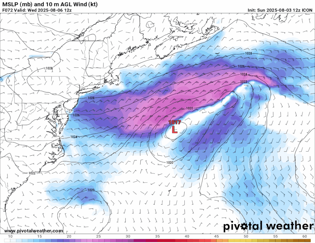
12z icon is a bit more aggressive with the wake area of 95L (The area currently just east of Jacksonville, FL) for the outer banks.
0 likes
Who is online
Users browsing this forum: Google [Bot], hurricanes1234, ljmac75 and 127 guests