Tropical Wave Over the Far Eastern Atlantic: (Is Invest 97L)

This is the general tropical discussion area. Anyone can take their shot at predicting a storms path.

Moderator: S2k Moderators

Forum rules

The posts in this forum are NOT official forecasts and should not be used as such. They are just the opinion of the poster and may or may not be backed by sound meteorological data. They are NOT endorsed by any professional institution or STORM2K. For official information, please refer to products from the National Hurricane Center and National Weather Service.

Help Support Storm2K
Message
Author
User avatar
cycloneye
Admin
Admin
Posts: 145804
Age: 68
Joined: Thu Oct 10, 2002 10:54 am
Location: San Juan, Puerto Rico

Tropical Wave Over the Far Eastern Atlantic: (Is Invest 97L)

#1 Postby cycloneye » Wed Aug 06, 2025 7:24 pm

I think is time that the wave the models are developing, (forget tracks) deserve it's own thread to post the model runs, satelite images etc. Wave as of 8/6/25 at 8 PM EDT or 00:00 UTC is around Chad and will emerge on the weekend.

Image

Image
5 likes   
Visit the Caribbean-Central America Weather Thread where you can find at first post web cams,radars
and observations from Caribbean basin members Click Here

User avatar
Category5Kaiju
Category 5
Category 5
Posts: 4121
Joined: Thu Dec 24, 2020 12:45 pm
Location: Seattle

Re: Tropical Wave Inside Africa

#2 Postby Category5Kaiju » Wed Aug 06, 2025 7:39 pm

At least per the most recent GFS run, what really catches my attention is how quickly this storm seems to form just after exiting Africa, becoming what appears to be a named system right next to the Cape Verde islands. Given its very high intensity down the line, somewhat reminds me of storms like Irma, Florence, and Lorenzo in that regard as well.

Really hope not, but if some of these model guidances are correct, then this could be a very long thread.
8 likes   
Unless explicitly stated, all info in my posts is based on my own opinions and observations. Tropical storms and hurricanes can be extremely dangerous. Do not think you can beat Mother Nature. Refer to an accredited weather research agency or meteorologist if you need to make serious decisions regarding an approaching storm.

User avatar
Hurricaneman
Category 5
Category 5
Posts: 7362
Age: 45
Joined: Tue Aug 31, 2004 3:24 pm
Location: central florida

Re: Tropical Wave Inside Africa

#3 Postby Hurricaneman » Wed Aug 06, 2025 8:38 pm

I want what the GFS is having as it seems the GFS develops an area in between this and 96L sending it into the GOM and this is the area off the east coast on the 18z run

Seems a little overdone to me but it shows the pattern could be dangerous as we head to mid to late August
Last edited by Hurricaneman on Wed Aug 06, 2025 8:41 pm, edited 2 times in total.
0 likes   

User avatar
cycloneye
Admin
Admin
Posts: 145804
Age: 68
Joined: Thu Oct 10, 2002 10:54 am
Location: San Juan, Puerto Rico

Re: Tropical Wave Inside Africa

#4 Postby cycloneye » Wed Aug 06, 2025 8:40 pm

Hurricaneman wrote:I want what the GFS is having


For clarification, what do you want? Edited= Now I saw your post that you added what it was.
0 likes   
Visit the Caribbean-Central America Weather Thread where you can find at first post web cams,radars
and observations from Caribbean basin members Click Here

User avatar
cycloneye
Admin
Admin
Posts: 145804
Age: 68
Joined: Thu Oct 10, 2002 10:54 am
Location: San Juan, Puerto Rico

Re: Tropical Wave Inside Africa

#5 Postby cycloneye » Wed Aug 06, 2025 10:42 pm

00z ICON run has wave in that position at the end of it.

Image
0 likes   
Visit the Caribbean-Central America Weather Thread where you can find at first post web cams,radars
and observations from Caribbean basin members Click Here

User avatar
Hurricaneman
Category 5
Category 5
Posts: 7362
Age: 45
Joined: Tue Aug 31, 2004 3:24 pm
Location: central florida

Re: Tropical Wave Inside Africa

#6 Postby Hurricaneman » Wed Aug 06, 2025 11:58 pm

The 0zGFS seems to send this through Haiti this run

And then strengthens it in the western Caribbean
0 likes   

User avatar
Kohlecane
Category 2
Category 2
Posts: 597
Age: 33
Joined: Sun Jul 31, 2011 11:03 pm
Location: Beaufort, SC

Re: Tropical Wave Inside Africa

#7 Postby Kohlecane » Thu Aug 07, 2025 12:25 am

Things picking up it seems, this one in particular could be a big ACE contributor if things align correctly
0 likes   
Once I see the REDS and GREENS Converge on a Base Velocity. ... I'm There!!

This is NOT an Official Forecast....Just my Opinion. For official information, please refer to the NHC and NWS products.
HIGHLIGHTS : '13 El Reno Tornado : 2013 Storm Chaser Tour, Joaquin; SC flood event, Matthew '16, Lowcountry Snow storm Jan '18

User avatar
cycloneye
Admin
Admin
Posts: 145804
Age: 68
Joined: Thu Oct 10, 2002 10:54 am
Location: San Juan, Puerto Rico

Re: Tropical Wave Inside Africa

#8 Postby cycloneye » Thu Aug 07, 2025 4:38 am

The 00z European develops wave near the Leeward Islands and tracks thru PR and DR.

Image
0 likes   
Visit the Caribbean-Central America Weather Thread where you can find at first post web cams,radars
and observations from Caribbean basin members Click Here

User avatar
cycloneye
Admin
Admin
Posts: 145804
Age: 68
Joined: Thu Oct 10, 2002 10:54 am
Location: San Juan, Puerto Rico

Re: Tropical Wave Inside Africa

#9 Postby cycloneye » Thu Aug 07, 2025 5:10 am

The euro run ends just north of Yucatán as a powerful hurricane.

Image

Image
0 likes   
Visit the Caribbean-Central America Weather Thread where you can find at first post web cams,radars
and observations from Caribbean basin members Click Here

User avatar
GCANE
S2K Supporter
S2K Supporter
Posts: 11509
Joined: Mon Oct 22, 2007 8:03 am

Re: Tropical Wave Inside Africa

#10 Postby GCANE » Thu Aug 07, 2025 5:32 am

Amazing, this far out how much EURO and GFS are in sync.
I have a bad feeling about this one.
3 likes   

BobHarlem
Category 5
Category 5
Posts: 2198
Joined: Thu Oct 20, 2005 6:11 pm

Re: Tropical Wave Inside Africa

#11 Postby BobHarlem » Thu Aug 07, 2025 5:57 am

Still model inconsistency... The 6z GFS has backed off a lot on the wave east of 96L, basically follows the GFS path of 96L now, recurving just west of Bermuda and much weaker with it overall. 0z Euro and Canadian get it into the Caribbean. Euro AI still showcasing it's apparent thing for South Florida.
Last edited by BobHarlem on Thu Aug 07, 2025 6:59 am, edited 3 times in total.
0 likes   

User avatar
Kohlecane
Category 2
Category 2
Posts: 597
Age: 33
Joined: Sun Jul 31, 2011 11:03 pm
Location: Beaufort, SC

Re: Tropical Wave Inside Africa

#12 Postby Kohlecane » Thu Aug 07, 2025 6:01 am

GCANE wrote:Amazing, this far out how much EURO and GFS are in sync.
I have a bad feeling about this one.

I was just thinking that very interesting
1 likes   
Once I see the REDS and GREENS Converge on a Base Velocity. ... I'm There!!

This is NOT an Official Forecast....Just my Opinion. For official information, please refer to the NHC and NWS products.
HIGHLIGHTS : '13 El Reno Tornado : 2013 Storm Chaser Tour, Joaquin; SC flood event, Matthew '16, Lowcountry Snow storm Jan '18

User avatar
cycloneye
Admin
Admin
Posts: 145804
Age: 68
Joined: Thu Oct 10, 2002 10:54 am
Location: San Juan, Puerto Rico

Re: Tropical Wave Inside Africa

#13 Postby cycloneye » Thu Aug 07, 2025 6:14 am

BobHarlem was talking about this. The trend between 00z and 06z of GFS is very large.

Image
0 likes   
Visit the Caribbean-Central America Weather Thread where you can find at first post web cams,radars
and observations from Caribbean basin members Click Here

User avatar
Category5Kaiju
Category 5
Category 5
Posts: 4121
Joined: Thu Dec 24, 2020 12:45 pm
Location: Seattle

Re: Tropical Wave Inside Africa

#14 Postby Category5Kaiju » Thu Aug 07, 2025 7:16 am

The GFS, Euro, CMC, ICON, and AI Euro all at least show hints of this wave and are fairly consistent with the August 11-13 timeframe of its MDR launch.
0 likes   
Unless explicitly stated, all info in my posts is based on my own opinions and observations. Tropical storms and hurricanes can be extremely dangerous. Do not think you can beat Mother Nature. Refer to an accredited weather research agency or meteorologist if you need to make serious decisions regarding an approaching storm.

User avatar
Blown Away
S2K Supporter
S2K Supporter
Posts: 10158
Joined: Wed May 26, 2004 6:17 am

Re: Tropical Wave Inside Africa

#15 Postby Blown Away » Thu Aug 07, 2025 7:29 am

Image
00z ECENS
Image
12z ECENS

00z ECENS really backed off the C Atlantic system in favor of a system in the SW Atlantic...
1 likes   
Hurricane Eye Experience: David 79, Irene 99, Frances 04, Jeanne 04, Wilma 05… Hurricane Brush Experience: Andrew 92, Erin 95, Floyd 99, Matthew 16, Irma 17, Ian 22, Nicole 22…

LarryWx
S2K Supporter
S2K Supporter
Posts: 6387
Joined: Sun Sep 07, 2003 2:04 pm
Location: GA

Re: Tropical Wave Inside Africa

#16 Postby LarryWx » Thu Aug 07, 2025 8:11 am

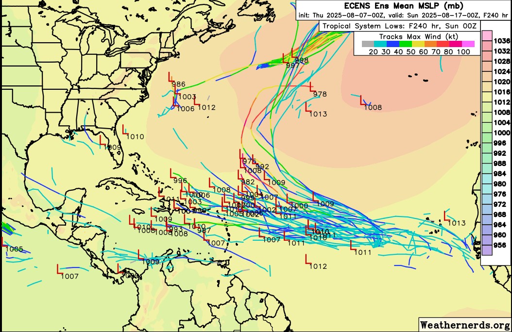
Blown Away wrote:[url]https://i.postimg.cc/hvKmT2xD/00z-ECENS.jpg [/url]
00z ECENS
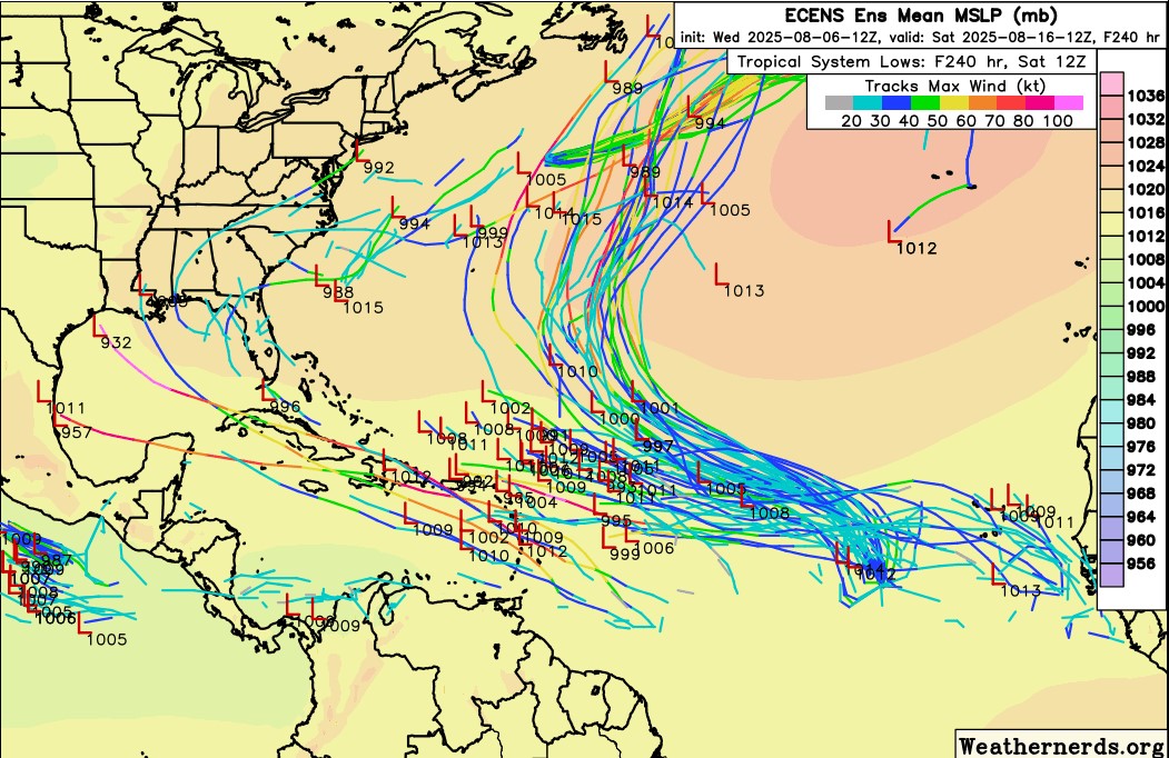
[url]https://i.postimg.cc/nrVsCCbM/12z-ECENS.jpg [/url]
12z ECENS

00z ECENS really backed off the C Atlantic system in favor of a system in the SW Atlantic...


However, the 6Z Euro ens 144 hour (end of run) is more active and quite possibly the most active run yet with this AEW. I count 19 closed sfc lows with 4 of those being sub 1000 mb. This is unfortunately setting up to be a potentially very dangerous system down the road for some land areas and is something the Euro Weeklies have been on top of for at least the last 9 days.

For the Conus, itself, I’ll especially be interested in whether or not the MJO is going to be either in or nearby phase 2 (inside or outside the circle), the most dangerous phase per the last 50 years of tracks, around two weeks from now. Model consensus is at least hinting at that possibility.
2 likes   
Personal Forecast Disclaimer:
The posts in this forum are NOT official forecasts and should not be used as such. They are just the opinion of the poster and may or may not be backed by sound meteorological data. They are NOT endorsed by any professional institution or storm2k.org. For official information, please refer to the NHC and NWS products.

User avatar
cycloneye
Admin
Admin
Posts: 145804
Age: 68
Joined: Thu Oct 10, 2002 10:54 am
Location: San Juan, Puerto Rico

Re: Tropical Wave Inside Africa

#17 Postby cycloneye » Thu Aug 07, 2025 8:52 am

0 likes   
Visit the Caribbean-Central America Weather Thread where you can find at first post web cams,radars
and observations from Caribbean basin members Click Here

LarryWx
S2K Supporter
S2K Supporter
Posts: 6387
Joined: Sun Sep 07, 2003 2:04 pm
Location: GA

Re: Tropical Wave Inside Africa

#18 Postby LarryWx » Thu Aug 07, 2025 11:09 am

W African AEW:

1. The 12Z ICON is slightly stronger than the 0Z with the W African AEW. At 180, it has what already looks like a TD (1008 mb well organized low) at 19N, 46W. Although a TC near that position often recurves safely, this one is turning back to just N of due W after moving WNW earlier due to a stronger high to its north at this longitude.

2. The 12Z UKMET doesn’t have this. However, the 0Z had this data, which may or may not be from the same AEW:

NEW TROPICAL CYCLONE FORECAST TO DEVELOP AFTER 114 HOURS
FORECAST POSITION AT T+114 : 15.4N 18.6W

LEAD CENTRAL MAXIMUM WIND
VERIFYING TIME TIME POSITION PRESSURE (MB) SPEED (KNOTS)
-------------- ---- -------- ------------- -------------
0000UTC 12.08.2025 120 15.6N 21.0W 1009 28
1200UTC 12.08.2025 132 15.0N 24.0W 1010 27
0000UTC 13.08.2025 144 15.4N 26.0W 1010 23
1200UTC 13.08.2025 156 CEASED TRACKING
1 likes   
Personal Forecast Disclaimer:
The posts in this forum are NOT official forecasts and should not be used as such. They are just the opinion of the poster and may or may not be backed by sound meteorological data. They are NOT endorsed by any professional institution or storm2k.org. For official information, please refer to the NHC and NWS products.

User avatar
cycloneye
Admin
Admin
Posts: 145804
Age: 68
Joined: Thu Oct 10, 2002 10:54 am
Location: San Juan, Puerto Rico

Re: Tropical Wave Inside Africa

#19 Postby cycloneye » Thu Aug 07, 2025 11:39 am

12z GFS develops wave more earlier than in past runs and moves away from the NE Caribbean Islands. 96L is a factor as the model develops a hurricane and opens a avenue and that is why it evades the Caribbean.Let's see down the road how the run ends.

Image
2 likes   
Visit the Caribbean-Central America Weather Thread where you can find at first post web cams,radars
and observations from Caribbean basin members Click Here

User avatar
cycloneye
Admin
Admin
Posts: 145804
Age: 68
Joined: Thu Oct 10, 2002 10:54 am
Location: San Juan, Puerto Rico

Re: Tropical Wave Inside Africa

#20 Postby cycloneye » Thu Aug 07, 2025 12:23 pm

12z GFS runs ends with a powerful hurricane / extratropical cyclone in the north atlantic and there is anything else on the basin.

Image
1 likes   
Visit the Caribbean-Central America Weather Thread where you can find at first post web cams,radars
and observations from Caribbean basin members Click Here


Return to “Talkin' Tropics”

Who is online

Users browsing this forum: duilaslol, Google [Bot], Ulf and 22 guests