2025 Indicators: SST's, MSLP, Shear, SAL, Steering, Instability (Day 16+ Climate Models)

This is the general tropical discussion area. Anyone can take their shot at predicting a storms path.

Moderator: S2k Moderators

Forum rules

The posts in this forum are NOT official forecasts and should not be used as such. They are just the opinion of the poster and may or may not be backed by sound meteorological data. They are NOT endorsed by any professional institution or STORM2K. For official information, please refer to products from the National Hurricane Center and National Weather Service.

Help Support Storm2K
Message
Author
User avatar
Category5Kaiju
Category 5
Category 5
Posts: 4145
Joined: Thu Dec 24, 2020 12:45 pm
Location: Seattle

Re: 2025 Indicators: SST's, MSLP, Shear, SAL, Steering, Instability (Day 16+ Climate Models)

#501 Postby Category5Kaiju » Tue Aug 05, 2025 8:01 pm

DorkyMcDorkface wrote:

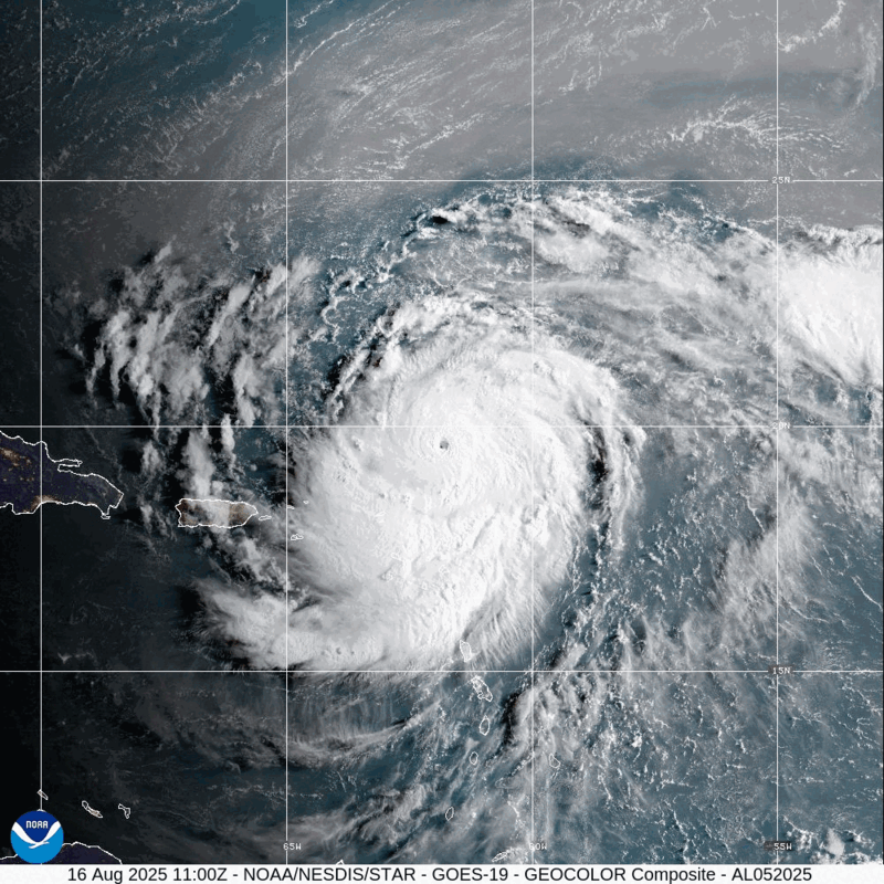
This feels like jumping the gun, no? I know Webb has been persistently bearish on his seasonal outlook but there's been model/ensemble support for TCG in the tropical Atlantic for the first two weeks of this month for a while now. If there were nothing in the pipeline appearing on the guidance I would agree, but that's not the case.


Wait, I'm kind of scratching my head here; is he being bearish and bullish simultaneously? :lol:

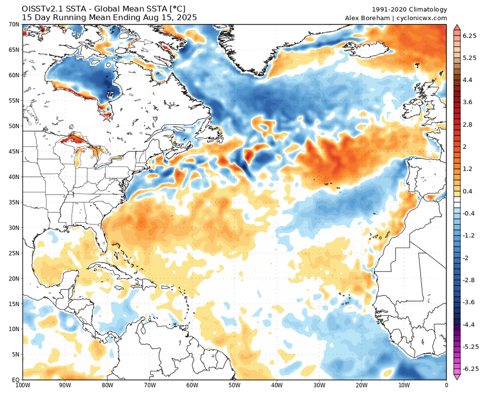
But yeah I do agree, nothing solid yet, but there's literal model support all over the place for activity to pick up in the coming weeks. In fact, 2025 seems to be outperforming 2022 and 2024 by this measure alone, interestingly enough.
4 likes   
Unless explicitly stated, all info in my posts is based on my own opinions and observations. Tropical storms and hurricanes can be extremely dangerous. Do not think you can beat Mother Nature. Refer to an accredited weather research agency or meteorologist if you need to make serious decisions regarding an approaching storm.

User avatar
cycloneye
Admin
Admin
Posts: 146106
Age: 69
Joined: Thu Oct 10, 2002 10:54 am
Location: San Juan, Puerto Rico

Re: 2025 Indicators: SST's, MSLP, Shear, SAL, Steering, Instability (Day 16+ Climate Models)

#502 Postby cycloneye » Wed Aug 06, 2025 10:37 am

Breaking=Looking like a backloaded season.

 https://x.com/BenNollWeather/status/1953112580047946007

0 likes   
Visit the Caribbean-Central America Weather Thread where you can find at first post web cams,radars
and observations from Caribbean basin members Click Here

User avatar
cycloneye
Admin
Admin
Posts: 146106
Age: 69
Joined: Thu Oct 10, 2002 10:54 am
Location: San Juan, Puerto Rico

Re: 2025 Indicators: SST's, MSLP, Shear, SAL, Steering, Instability (Day 16+ Climate Models)

#503 Postby cycloneye » Thu Aug 07, 2025 7:14 pm

Agree 1,000% with Eric Webb about is now or never for the 2025 season to put a solid performance or if not, then you know the rest. And yes, that number begins to flourish, 2013. :D And another yes, those season cancel posts would be prevalent. :D

@webberweather
Rarely do things line up as favorably for tropical development subseasonally as they will next week in the East Atlantic

Hard to get the MJO, a CCKW, & an Eq Rossby Wave this strong to all line up at once

This will be a good litmus test of how favorable the Atlantic is this yr


 https://x.com/webberweather/status/1953599802362802228

2 likes   
Visit the Caribbean-Central America Weather Thread where you can find at first post web cams,radars
and observations from Caribbean basin members Click Here

User avatar
Spacecoast
Category 2
Category 2
Posts: 760
Joined: Thu Aug 31, 2017 2:03 pm

Re: 2025 Indicators: SST's, MSLP, Shear, SAL, Steering, Instability (Day 16+ Climate Models)

#504 Postby Spacecoast » Fri Aug 08, 2025 3:26 pm

Pure fantasyland, but here is the 4 week (840Hr) GEFS run from last night 0z...

Image
1 likes   

User avatar
ScottNAtlanta
Category 5
Category 5
Posts: 2419
Joined: Sat May 25, 2013 3:11 pm
Location: Atlanta, GA

Re: 2025 Indicators: SST's, MSLP, Shear, SAL, Steering, Instability (Day 16+ Climate Models)

#505 Postby ScottNAtlanta » Fri Aug 08, 2025 5:42 pm

Spacecoast wrote:Pure fantasyland, but here is the 4 week (840Hr) GEFS run from last night 0z...

https://i.ibb.co/TMYNLBvY/floop-gefsens-2025080700-sfcmslp-meanmem-atl.gif

Looks like a bunch of bugs
1 likes   
The posts in this forum are NOT official forecast and should not be used as such. They are just the opinion of the poster and may or may not be backed by sound meteorological data. They are NOT endorsed by any professional institution or storm2k.org. For official information, please refer to the NHC and NWS products.

User avatar
chaser1
S2K Supporter
S2K Supporter
Posts: 5509
Age: 64
Joined: Sat Oct 15, 2005 5:59 pm
Location: Longwood, Fl

Re: 2025 Indicators: SST's, MSLP, Shear, SAL, Steering, Instability (Day 16+ Climate Models)

#506 Postby chaser1 » Sat Aug 09, 2025 3:01 am

Sure appears that our typically strong West Atlantic ridge, is well north and east of the norm. That could present a heightened threat to New England, Bermuda, and the Canadian Maritines (perhaps the Azores while we're at it).


May just be a primarily big recurve season.
1 likes   
Andy D

(For official information, please refer to the NHC and NWS products.)

User avatar
Hurrilurker
Category 2
Category 2
Posts: 727
Joined: Mon Jun 09, 2003 3:32 pm
Location: San Francisco, CA

Re: 2025 Indicators: SST's, MSLP, Shear, SAL, Steering, Instability (Day 16+ Climate Models)

#507 Postby Hurrilurker » Sat Aug 09, 2025 12:31 pm

chaser1 wrote:Sure appears that our typically strong West Atlantic ridge, is well north and east of the norm. That could present a heightened threat to New England, Bermuda, and the Canadian Maritines (perhaps the Azores while we're at it).


May just be a primarily big recurve season.

Maybe...but near the end of the forecast, early September, it starts building back in on the west side, which could cap off the north exit and funnel some later storms into CONUS. And maybe having it so far east keeps some long-trackers from going fishing early.

It definitely looks weird to have the high that much offset though (but it's still huge, covering almost all of the North Atlantic).
2 likes   

WeatherBoy2000
Category 1
Category 1
Posts: 389
Joined: Mon Apr 10, 2023 9:29 am

Re: 2025 Indicators: SST's, MSLP, Shear, SAL, Steering, Instability (Day 16+ Climate Models)

#508 Postby WeatherBoy2000 » Mon Aug 11, 2025 8:10 am

Unsurprisingly, there will likely be more development opportunities after 97l as we enter the peak:

 https://x.com/webberweather/status/1954889249167429736

5 likes   

User avatar
Category5Kaiju
Category 5
Category 5
Posts: 4145
Joined: Thu Dec 24, 2020 12:45 pm
Location: Seattle

Re: 2025 Indicators: SST's, MSLP, Shear, SAL, Steering, Instability (Day 16+ Climate Models)

#509 Postby Category5Kaiju » Mon Aug 11, 2025 10:07 am

We're now looking at the very real possibility of a long-tracking major hurricane and what also looks to be a heightened period of possible tropical cyclogenesis to close out the month. Mind you too, it's currently August 11; bell-ringing isn't even supposed to happen for another 9 days.

It's somewhat ironic that the year that was allegedly supposed to have stability issues, struggles with Atlantic Nina, etc. also managed to defy the recent patterns of an unfavorable mid-August (mayyybeee with the exception of 2021). I didn't want to speak too soon, but it's looking ever so likely that some of those talks were *slightly* overblown and that the June/July we had this year was fairly normal in the grand scheme of things.

And, of course, I think at this point we can safely say that the specter of 2013 will never get to haunt the 2025 season :lol:
7 likes   
Unless explicitly stated, all info in my posts is based on my own opinions and observations. Tropical storms and hurricanes can be extremely dangerous. Do not think you can beat Mother Nature. Refer to an accredited weather research agency or meteorologist if you need to make serious decisions regarding an approaching storm.

tolakram
Admin
Admin
Posts: 20027
Age: 62
Joined: Sun Aug 27, 2006 8:23 pm
Location: Florence, KY (name is Mark)

Re: 2025 Indicators: SST's, MSLP, Shear, SAL, Steering, Instability (Day 16+ Climate Models)

#510 Postby tolakram » Mon Aug 11, 2025 10:26 am

Category5Kaiju wrote:We're now looking at the very real possibility of a long-tracking major hurricane and what also looks to be a heightened period of possible tropical cyclogenesis to close out the month. Mind you too, it's currently August 11; bell-ringing isn't even supposed to happen for another 9 days.

It's somewhat ironic that the year that was allegedly supposed to have stability issues, struggles with Atlantic Nina, etc. also managed to defy the recent patterns of an unfavorable mid-August (mayyybeee with the exception of 2021). I didn't want to speak too soon, but it's looking ever so likely that some of those talks were *slightly* overblown and that the June/July we had this year was fairly normal in the grand scheme of things.

And, of course, I think at this point we can safely say that the specter of 2013 will never get to haunt the 2025 season :lol:


Same as every year, fighting the most recent years battles, making bad comparisons, etc. Fun, sometimes, accurate, rarely. :)

The Atlantic has had below normal stability going on 15 years now. I worry when I see some continuing to ignore this broken metric.
6 likes   
M a r k
- - - - -
Join us in chat: Storm2K Chatroom Invite. Android and IOS apps also available.

The posts in this forum are NOT official forecasts and should not be used as such. Posts are NOT endorsed by any professional institution or STORM2K.org. For official information and forecasts, please refer to NHC and NWS products.

User avatar
chaser1
S2K Supporter
S2K Supporter
Posts: 5509
Age: 64
Joined: Sat Oct 15, 2005 5:59 pm
Location: Longwood, Fl

Re: 2025 Indicators: SST's, MSLP, Shear, SAL, Steering, Instability (Day 16+ Climate Models)

#511 Postby chaser1 » Tue Aug 12, 2025 1:36 am

Interesting flare up suddenly appearing in the W. Caribbean. I only mention this because there appears to be evidence of rotation at some level right at about 12.5 N and 82.5 W. This likely to prove to be transitory in light of the entire area of disturbed weather moving off to the west/wnw. Along with Erin forming in the far E. Atlantic today, this might be indicative of our basin trying to wake up. One thing for sure, there's no problem with SST's west of 60W.
0 likes   
Andy D

(For official information, please refer to the NHC and NWS products.)

User avatar
Category5Kaiju
Category 5
Category 5
Posts: 4145
Joined: Thu Dec 24, 2020 12:45 pm
Location: Seattle

Re: 2025 Indicators: SST's, MSLP, Shear, SAL, Steering, Instability (Day 16+ Climate Models)

#512 Postby Category5Kaiju » Tue Aug 12, 2025 7:11 pm

So, here's what piques my curiosity in the meantime.

 https://x.com/WeathermanAAA_/status/1953896423683965298


Of course, this is simply one example of people's interpretations of some of the recent models that showed persistent ridging (and, therefore, a more dangerous pattern for landfalling storms). I also recall Webb doing an analysis of it some days ago, as well as much general talk on it in the wx community. With Erin's predicted track though, is it safe to say that these models busted? Did they simply not catch the trough that is expected to pull Erin OTS, or were there other variables at play?
1 likes   
Unless explicitly stated, all info in my posts is based on my own opinions and observations. Tropical storms and hurricanes can be extremely dangerous. Do not think you can beat Mother Nature. Refer to an accredited weather research agency or meteorologist if you need to make serious decisions regarding an approaching storm.

WeatherBoy2000
Category 1
Category 1
Posts: 389
Joined: Mon Apr 10, 2023 9:29 am

Re: 2025 Indicators: SST's, MSLP, Shear, SAL, Steering, Instability (Day 16+ Climate Models)

#513 Postby WeatherBoy2000 » Tue Aug 12, 2025 7:31 pm

Category5Kaiju wrote:So, here's what piques my curiosity in the meantime.

 https://x.com/WeathermanAAA_/status/1953896423683965298


Of course, this is simply one example of people's interpretations of some of the recent models that showed persistent ridging (and, therefore, a more dangerous pattern for landfalling storms). I also recall Webb doing an analysis of it some days ago, as well as much general talk on it in the wx community. With Erin's predicted track though, is it safe to say that these models busted? Did they simply not catch the trough that is expected to pull Erin OTS, or were there other variables at play?


"Limits the opportunity" doesn't mean no opportunity, I think we need to see more storms before we can declare anything. 2017 had a pattern that favored fewer recurves, but it still had them (Gert, Jose, and Lee).
2 likes   

User avatar
Kingarabian
S2K Supporter
S2K Supporter
Posts: 16075
Joined: Sat Aug 08, 2009 3:06 am
Location: Honolulu, Hawaii

Re: 2025 Indicators: SST's, MSLP, Shear, SAL, Steering, Instability (Day 16+ Climate Models)

#514 Postby Kingarabian » Fri Aug 15, 2025 6:01 pm

If the models are right, the last two weeks of August seem to be quite busy with Erin and another system. Atlantic would be behaving like its a cool neutral ENSO year.
4 likes   
RIP Kobe Bryant

User avatar
Category5Kaiju
Category 5
Category 5
Posts: 4145
Joined: Thu Dec 24, 2020 12:45 pm
Location: Seattle

Re: 2025 Indicators: SST's, MSLP, Shear, SAL, Steering, Instability (Day 16+ Climate Models)

#515 Postby Category5Kaiju » Sat Aug 16, 2025 10:19 am

With Erin officially being a 155-mph hurricane, 2025 continues a whopping 11-year streak where the strongest storm of the year is at least a 155-mph Category 4 hurricane or a bona-fide Category 5 hurricane.
5 likes   
Unless explicitly stated, all info in my posts is based on my own opinions and observations. Tropical storms and hurricanes can be extremely dangerous. Do not think you can beat Mother Nature. Refer to an accredited weather research agency or meteorologist if you need to make serious decisions regarding an approaching storm.

LarryWx
S2K Supporter
S2K Supporter
Posts: 6448
Joined: Sun Sep 07, 2003 2:04 pm
Location: GA

Re: 2025 Indicators: SST's, MSLP, Shear, SAL, Steering, Instability (Day 16+ Climate Models)

#516 Postby LarryWx » Sat Aug 16, 2025 10:20 am

1. 2024 (161 ACE) didn’t get 2nd major til late Sep.

2. 2023 (146) didn’t have 1st MH til 8/20.

3. 2021 (146) 1st MH 8/20.

4. 2020 (180) 8/26

5. 2019 (132) 8/30

6. 2018 (133) 9/10

7. 2017 (225) 8/25

8. 2016 (141) 8/30

———

 2025 got 1st MH on 8/16. Seasons with 1st MH by 8/16: 2024, 2008, 2005, 2004, 2000, 1996, 1995…only 7 of last 30 (23%).
2 likes   
Personal Forecast Disclaimer:
The posts in this forum are NOT official forecasts and should not be used as such. They are just the opinion of the poster and may or may not be backed by sound meteorological data. They are NOT endorsed by any professional institution or storm2k.org. For official information, please refer to the NHC and NWS products.

MarioProtVI
Category 4
Category 4
Posts: 946
Age: 24
Joined: Sun Sep 29, 2019 7:33 pm
Location: New Jersey

Re: 2025 Indicators: SST's, MSLP, Shear, SAL, Steering, Instability (Day 16+ Climate Models)

#517 Postby MarioProtVI » Sat Aug 16, 2025 10:38 am

Atlantic beating WPac once again to the punch in getting a Cat 5 :lol:
5 likes   

User avatar
Teban54
Category 5
Category 5
Posts: 3243
Joined: Sat May 19, 2018 1:19 pm

Re: 2025 Indicators: SST's, MSLP, Shear, SAL, Steering, Instability (Day 16+ Climate Models)

#518 Postby Teban54 » Sat Aug 16, 2025 12:33 pm

Something something cool MDR, something something warm subtropics inducing stability:

(15-day mean chosen to reduce the effects of Erin's cold wake)

Image

Something something inactive deep tropics:

Image
6 likes   

User avatar
Category5Kaiju
Category 5
Category 5
Posts: 4145
Joined: Thu Dec 24, 2020 12:45 pm
Location: Seattle

Re: 2025 Indicators: SST's, MSLP, Shear, SAL, Steering, Instability (Day 16+ Climate Models)

#519 Postby Category5Kaiju » Sat Aug 16, 2025 5:56 pm

To say that I'm concerned about the future of this season is....an understatement.

With Erin already reaching Category 5 status by mid-August and with rumblings of yet another storm originating in the deep tropics in the coming days/weeks that potentially looks to be more of a land threat than Erin, there's no telling what September and October are going to look like. The fact that we're getting such formidable activity in what recently has been a relatively dead period in the Atlantic, combined with the expected -ENSO trend, makes me think that we still have a lot of season left and that Erin may not be the only Category 5 hurricane we see this season.

I know there's been a lot of mixed signals early on this hurricane season, but at this point I think the tropics have really shown how they would like to proceed forward in terms of activity. Buckle up, and be prepared.
11 likes   
Unless explicitly stated, all info in my posts is based on my own opinions and observations. Tropical storms and hurricanes can be extremely dangerous. Do not think you can beat Mother Nature. Refer to an accredited weather research agency or meteorologist if you need to make serious decisions regarding an approaching storm.

Pas_Bon
Tropical Depression
Tropical Depression
Posts: 85
Age: 45
Joined: Mon Jul 15, 2019 12:25 pm
Location: League City, TX

Re: 2025 Indicators: SST's, MSLP, Shear, SAL, Steering, Instability (Day 16+ Climate Models)

#520 Postby Pas_Bon » Sun Aug 17, 2025 7:04 am

Category5Kaiju wrote:To say that I'm concerned about the future of this season is....an understatement.

With Erin already reaching Category 5 status by mid-August and with rumblings of yet another storm originating in the deep tropics in the coming days/weeks that potentially looks to be more of a land threat than Erin, there's no telling what September and October are going to look like. The fact that we're getting such formidable activity in what recently has been a relatively dead period in the Atlantic, combined with the expected -ENSO trend, makes me think that we still have a lot of season left and that Erin may not be the only Category 5 hurricane we see this season.

I know there's been a lot of mixed signals early on this hurricane season, but at this point I think the tropics have really shown how they would like to proceed forward in terms of activity. Buckle up, and be prepared.


Agreed. It’s going to be a rough go the next several weeks. Eat your Wheaties, folks.
0 likes   


Return to “Talkin' Tropics”

Who is online

Users browsing this forum: AnnularCane, Google Adsense [Bot], mcheer23, prairie2, saila, Stratton23, TampaWxLurker, TheBurn, Tireman4, tolakram and 133 guests