Evacuation order issued for the northern most section of the Outer Banks - the Off Road portion of Corolla, Currituck County. Overwash is expected to cut off the beach, which is the only access to the houses beyond.
https://www.witn.com/2025/08/20/curritu ... a-corolla/
ATL: ERIN - Post-Tropical - Discussion
Moderator: S2k Moderators
-
NC George

- Category 2

- Posts: 635
- Age: 56
- Joined: Sun Sep 14, 2003 11:44 am
- Location: Washington, NC, USA
Re: ATL: ERIN - Hurricane - Discussion
1 likes
Bertha '96, Fran '96, Bonnie '98, Dennis '99, Floyd '99  , Isabel '03, Irene '11, Matthew '16, Isaias '20, PTC16????
Avatar is heading into Florence 2018, moving friend's boat, only land between us and Hurricane Florence is Ocracoke Island!
Avatar is heading into Florence 2018, moving friend's boat, only land between us and Hurricane Florence is Ocracoke Island!

Re: ATL: ERIN - Hurricane - Discussion
NC George wrote:Evacuation order issued for the northern most section of the Outer Banks - the Off Road portion of Corolla, Currituck County. Overwash is expected to cut off the beach, which is the only access to the houses beyond.
https://www.witn.com/2025/08/20/curritu ... a-corolla/
Even with a king tide and strong wind, these houses in Corova can get cut off when ocean goes up to the base of dunes. Just seeing overwatch in Buxton and on Ocracoke would have had me packing!
0 likes

Re: ATL: ERIN - Hurricane - Discussion
72Packer wrote:NC George wrote:Evacuation order issued for the northern most section of the Outer Banks - the Off Road portion of Corolla, Currituck County. Overwash is expected to cut off the beach, which is the only access to the houses beyond.
https://www.witn.com/2025/08/20/curritu ... a-corolla/
Even with a king tide and strong wind, these houses in Corova can get cut off when ocean goes up to the base of dunes. Just seeing overwatch in Buxton and on Ocracoke would have had me packing!
When you see overwash in Buxton, isn't Oregon Inlet already cut off by surge; making evacuation from the outer banks already impossible?
0 likes
List of 79 tropical cyclones intercepted by Richard Horodner:
http://www.canebeard.com/page/page/572246.htm
former storm2k screenname Beoumont 2009+
http://www.canebeard.com/page/page/572246.htm
former storm2k screenname Beoumont 2009+

Re: ATL: ERIN - Hurricane - Discussion
canebeard wrote:72Packer wrote:NC George wrote:Evacuation order issued for the northern most section of the Outer Banks - the Off Road portion of Corolla, Currituck County. Overwash is expected to cut off the beach, which is the only access to the houses beyond.
https://www.witn.com/2025/08/20/curritu ... a-corolla/
Even with a king tide and strong wind, these houses in Corova can get cut off when ocean goes up to the base of dunes. Just seeing overwatch in Buxton and on Ocracoke would have had me packing!
When you see overwash in Buxton, isn't Oregon Inlet already cut off by surge; making evacuation from the outer banks already impossible?
this area (Corova, Corolla) is north of Oregon Inlet almost on the VA/NC border. Access to the mainland from this area doesn't involve crossing Oregon Inlet.
0 likes
-
tolakram
- Admin

- Posts: 20185
- Age: 62
- Joined: Sun Aug 27, 2006 8:23 pm
- Location: Florence, KY (name is Mark)
Re: ATL: ERIN - Hurricane - Discussion

8 likes
M a r k
- - - - -
Join us in chat: Storm2K Chatroom Invite. Android and IOS apps also available.
The posts in this forum are NOT official forecasts and should not be used as such. Posts are NOT endorsed by any professional institution or STORM2K.org. For official information and forecasts, please refer to NHC and NWS products.

Re: ATL: ERIN - Hurricane - Discussion
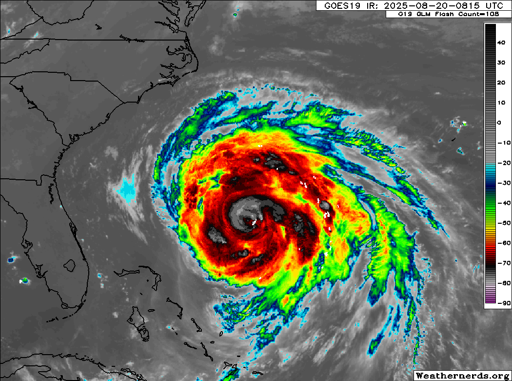
Erin is becoming quite a unique storm. The first recon pass found FL winds of only 83 kt near the eye of the storm, which would translate to an intensity of 75 to 85 kt depending on how strongly you factor in undersampling in such a big storm. A typical undersampling factor for such a large RMW (>30 nm) in a C1/C2 storm is about 10%, which balances the FL to surface wind conversion so in this case the FL values are pretty much the same as the surface wind estimate. However, the dropsonde shows a very intense storm with a central pressure of 948 mb. Furthermore, in the NE quadrant of Erin the plane found 99 kt FL winds which could support at least 90 to 95 kt.
For now I'd personally keep the intensity at 85 kt and the pressure at 948 mb, but this is a weird storm for sure. Almost starting to exhibit extratropical characteristics. Recon is finding hurricane force winds (still 77 kt FL) 85 miles north of the center. Almost giving me Sandy vibes.
Edit: Just checked and Sandy was still twice as big as Erin in terms of TS winds. So it's no Sandy. But still, Erin is definitely a very large hurricane. Hurricane force winds now extend farther than even Irma at her peak.
Last edited by kevin on Wed Aug 20, 2025 7:31 am, edited 1 time in total.
0 likes

Re: ATL: ERIN - Hurricane - Discussion
BobHarlem wrote:Erin is massive
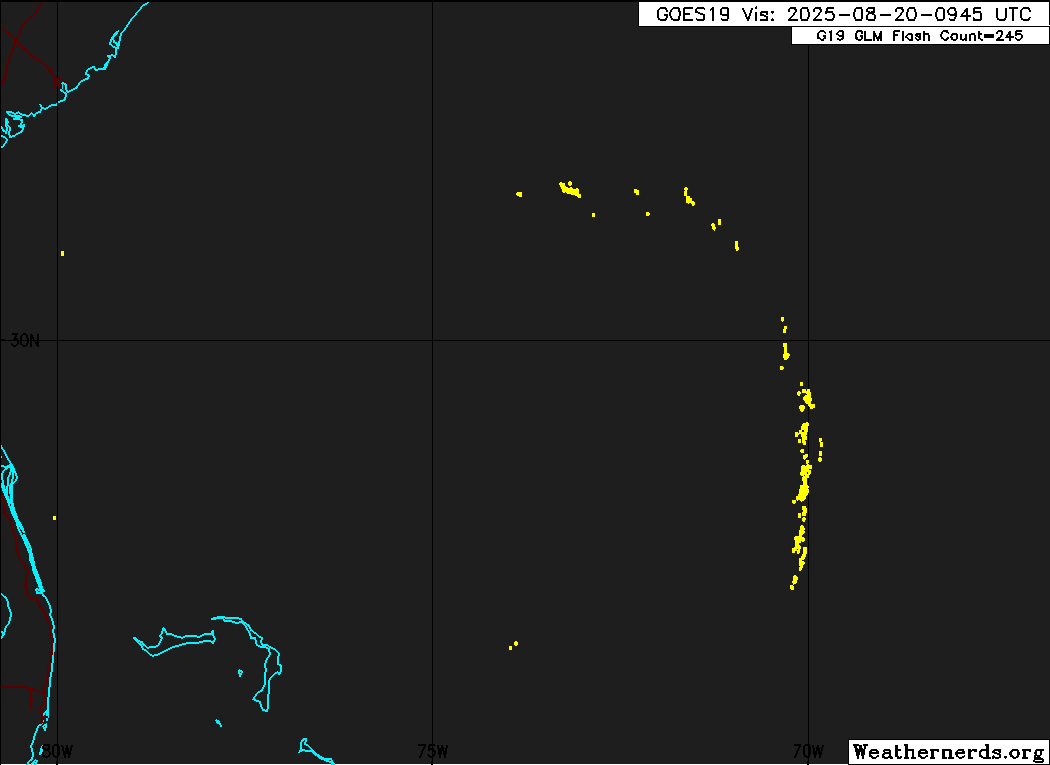
https://i.postimg.cc/YCjh9bn6/24484807.gif
SW quadrant really getting mashed in.
0 likes
I'm not a meteorologist, I'm an electronics engineer. While I can probably fix your toaster oven, you're not going to learn about storms from me!
New Mexico had no hurricanes. Then I moved to NC right before Fran.....
New Mexico had no hurricanes. Then I moved to NC right before Fran.....
-
TomballEd
- Category 5

- Posts: 1292
- Age: 62
- Joined: Wed Aug 16, 2023 4:52 pm
- Location: Spring/Klein area, not Tomball
Re: ATL: ERIN - Hurricane - Discussion
kevin wrote:Erin is becoming quite a unique storm. The first recon pass found FL winds of only 83 kt near the eye of the storm, which would translate to an intensity of 75 to 85 kt depending on how strongly you factor in undersampling in such a big storm. A typical undersampling factor for such a large RMW (>30 nm) in a C1/C2 storm is about 10%, which balances the FL to surface wind conversion so in this case the FL values are pretty much the same as the surface wind estimate. However, the dropsonde shows a very intense storm with a central pressure of 948 mb. Furthermore, in the NE quadrant of Erin the plane found 99 kt FL winds which could support at least 90 to 95 kt.
For now I'd personally keep the intensity at 85 kt and the pressure at 948 mb, but this is a weird storm for sure. Almost starting to exhibit extratropical characteristics. Recon is finding hurricane force winds (still 77 kt FL) 85 miles north of the center. Almost giving me Sandy vibes.
Edit: Just checked and Sandy was still twice as big as Erin in terms of TS winds. So it's no Sandy. But still, Erin is definitely a very large hurricane. Hurricane force winds now extend farther than even Irma at her peak.
If I recall, Sandy was already merging with the trough that was pulling it back in and by satellite didn't look particularly tropical. Erin still looks like a tropical system.
0 likes
-
ScottNAtlanta

- Category 5
- Posts: 2535
- Joined: Sat May 25, 2013 3:11 pm
- Location: Atlanta, GA
Re: ATL: ERIN - Hurricane - Discussion
Looks like we have an eye again

5 likes
The posts in this forum are NOT official forecast and should not be used as such. They are just the opinion of the poster and may or may not be backed by sound meteorological data. They are NOT endorsed by any professional institution or storm2k.org. For official information, please refer to the NHC and NWS products.
Re: ATL: ERIN - Hurricane - Discussion
Has to be one of the coolest-looking hurricanes I've seen. Almost looks like a spiral band galaxy.

9 likes
Re: ATL: ERIN - Hurricane - Discussion
Part of the eye becoming visible again, Still very cloud filled though.
0 likes
-
HurricaneBelle

- S2K Supporter

- Posts: 1209
- Joined: Sun Aug 27, 2006 6:12 pm
- Location: Clearwater, FL
Re: ATL: ERIN - Hurricane - Discussion
More impressively there's lightning in the core, something you don't usually see from mature hurricanes like this.
4 likes
-
MarioProtVI
- Category 5
- Posts: 1034
- Age: 24
- Joined: Sun Sep 29, 2019 7:33 pm
- Location: New Jersey
Re: ATL: ERIN - Hurricane - Discussion
Erin’s broad size is preventing it from taking advantage of the favorable conditions. Very reminiscent of Earl 2022. Not quite sure it makes it back to Cat 3
1 likes
Re: ATL: ERIN - Hurricane - Discussion
Pressure now down to ~941 mb (943 mb with 19 kt wind) based on the second dropsonde. That's a drop of roughly 7 mb since the previous dropsonde. Recon now also found 92 kt FL wind in the eyewall and again higher FL wind farther away from the eye, this time even 110 kt in the SE quadrant. The 92 kt measurement is definitely enough to keep the 85 kt intensity, I don't really know how to factor in the 110 kt FL measurement.

2 likes
-
WeatherBoy2000
- Category 1

- Posts: 461
- Joined: Mon Apr 10, 2023 9:29 am
Re: ATL: ERIN - Hurricane - Discussion
MarioProtVI wrote:Erin’s broad size is preventing it from taking advantage of the favorable conditions. Very reminiscent of Earl 2022. Not quite sure it makes it back to Cat 3
Erin now has an eye again and has dropped 5mb between passes, it's definitely taking advantage of the more favorable conditions.
4 likes
-
TallyTracker
- Category 2
- Posts: 787
- Joined: Thu Oct 11, 2018 2:46 pm
Re: ATL: ERIN - Hurricane - Discussion
The dry air in the spirals may help continue expanding the wind field and reducing peak wind speeds. The pressure may be insanely low though. That’s not uncommon with systems heading into the higher latitudes. Fiona landfalled as a post-tropical cyclone in Nova Scotia with 100 mph winds and a 931 mb central pressure.
1 likes
Fran '96, Georges '98, Gordon '00, Gabrielle '01, Charley '04, Frances '04, Jeanne '04, Barry '07, Fay '08, Debby '12, Matthew '16, Emily '17, Irma '17, Michael ‘18, Elsa ‘21, Fred ‘21, Mindy ‘21, Nicole ‘22, Idalia ‘23, Debby ‘24, Helene ‘24

Re: ATL: ERIN - Hurricane - Discussion
12Z Best Track:
And the pressure has since dropped a further 7 millibars, you say? That's bound to translate into intensification and/or expansion of her wind field.
In the words of Jonny Bravo,
Whoa mama!
AL, 05, 2025082012, , BEST, 0, 296N, 737W, 90, 948, HU
And the pressure has since dropped a further 7 millibars, you say? That's bound to translate into intensification and/or expansion of her wind field.
In the words of Jonny Bravo,
Whoa mama!
2 likes
Re: ATL: ERIN - Hurricane - Discussion
Considering recent developments, it may be prudent for Bermuda to upgrade their tropical-storm watch to a tropical-storm warning.
0 likes
-
TampaWxLurker
- Tropical Storm

- Posts: 196
- Joined: Thu Aug 01, 2024 8:20 am
Who is online
Users browsing this forum: No registered users and 5 guests