2025 Indicators: SST's, MSLP, Shear, SAL, Steering, Instability (Day 16+ Climate Models)

This is the general tropical discussion area. Anyone can take their shot at predicting a storms path.

Moderator: S2k Moderators

Forum rules

The posts in this forum are NOT official forecasts and should not be used as such. They are just the opinion of the poster and may or may not be backed by sound meteorological data. They are NOT endorsed by any professional institution or STORM2K. For official information, please refer to products from the National Hurricane Center and National Weather Service.

Help Support Storm2K
Message
Author
User avatar
Teban54
Category 5
Category 5
Posts: 3523
Joined: Sat May 19, 2018 1:19 pm

Re: 2025 Indicators: SST's, MSLP, Shear, SAL, Steering, Instability (Day 16+ Climate Models)

#661 Postby Teban54 » Wed Sep 24, 2025 11:47 pm

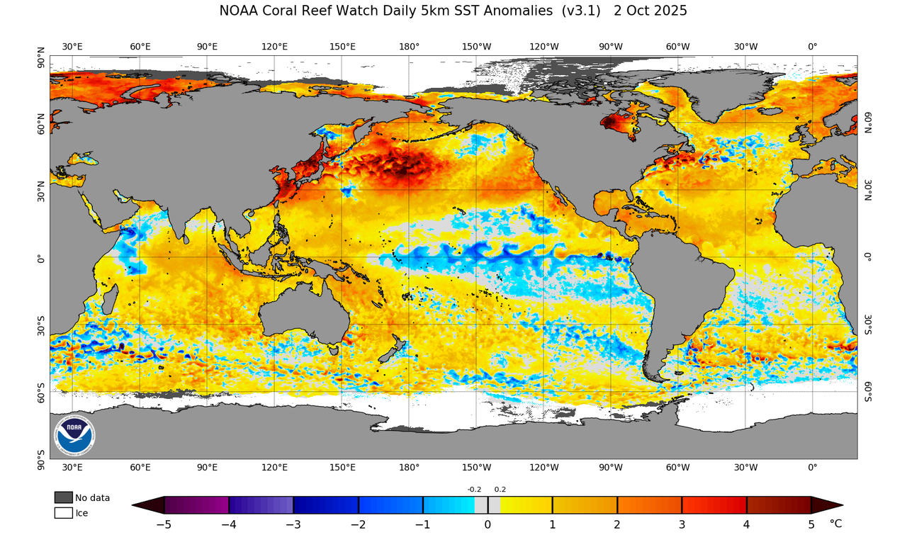
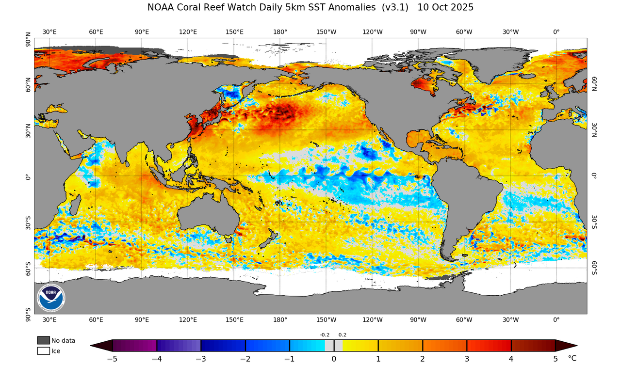
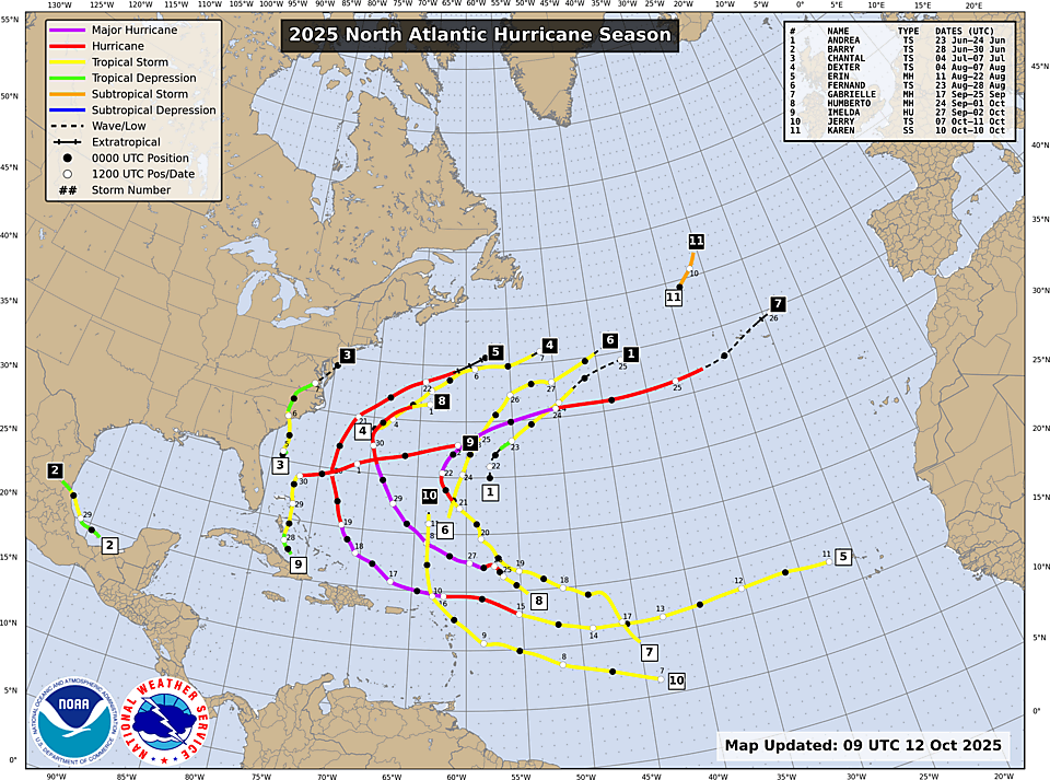
galaxy401 wrote: Only 48 hours later and things are suggesting otherwise. Had a Category 4 hurricane and a new storm that will probably be the third major. And who knows what the other Invest does.

This season looks like a near repeat of 2024 so far.

In fact, 2025's sudden uptick is even slightly earlier than 2024's, albeit only by a few days. Gabrielle became a major on 9/22, and by 9/23 it was clear that we'll likely get yet another major. Even though 2024's early and mid September wasn't as dead as this year's, its reputation only started to really turn around with Helene, which formed on 9/24 and became the second MH of the season two days later.
9 likes   

psyclone
S2K Supporter
S2K Supporter
Posts: 4788
Joined: Wed Aug 24, 2005 9:04 pm
Location: palm harbor fl

Re: 2025 Indicators: SST's, MSLP, Shear, SAL, Steering, Instability (Day 16+ Climate Models)

#662 Postby psyclone » Thu Sep 25, 2025 11:04 am

Well it seems as if we have exited the peak season dead streak and may actually stack some ace and use some names.
4 likes   

CrazyC83
Professional-Met
Professional-Met
Posts: 34127
Joined: Tue Mar 07, 2006 11:57 pm
Location: Deep South, for the first time!

Re: 2025 Indicators: SST's, MSLP, Shear, SAL, Steering, Instability (Day 16+ Climate Models)

#663 Postby CrazyC83 » Sat Sep 27, 2025 4:04 pm

How does this season compare to 1988 and 2007 in terms of the overall environmental patterns? It seems those have become comparable seasons.
1 likes   

User avatar
aspen
Category 5
Category 5
Posts: 8917
Joined: Sat Oct 12, 2019 7:10 pm
Location: Connecticut, USA

Re: 2025 Indicators: SST's, MSLP, Shear, SAL, Steering, Instability (Day 16+ Climate Models)

#664 Postby aspen » Sat Sep 27, 2025 6:05 pm

What’s perhaps even more remarkable about this season’s majors and Cat 5s is how minimal land impacts have been. Both Cat 5s reached their peaks in very similar spots north of the islands, and depending on Humberto’s track, should both finish without any major land impacts. Gabrielle avoided significant Bermuda impacts too.

Compare this to last year’s majors. Beryl brought significant impacts to the Lesser Antilles and Texas, then once activity began picking up again in late September, Helene clobbered Florida and the Carolinas.

I can’t recall any other season where its first 3 majors all spared the US and islands of any notable impacts — much less a season where both Cat 5s did too. Just adds to 2025’s weirdness. We’re fortunate that many of the ways 2025 has been odd have led to a low-impact season for now.
9 likes   
Irene '11 Sandy '12 Hermine '16 5/15/2018 Derecho Fay '20 Isaias '20 Elsa '21 Henri '21 Ida '21

I am only a meteorology enthusiast who knows a decent amount about tropical cyclones. Look to the professional mets, the NHC, or your local weather office for the best information.

User avatar
Hurricane2022
Category 5
Category 5
Posts: 1750
Joined: Tue Aug 23, 2022 11:38 pm
Location: Araçatuba, Brazil

Re: 2025 Indicators: SST's, MSLP, Shear, SAL, Steering, Instability (Day 16+ Climate Models)

#665 Postby Hurricane2022 » Sat Sep 27, 2025 8:24 pm

1 likes   
Sorry for the bad English sometimes...!
For reliable and detailed information for any meteorological phenomenon, please consult the National Hurricane Center, Joint Typhoon Warning Center , or your local Meteo Center.

--------

Una cvm Christo, pro Christo, et in Christo. Sit nomen Domini benedictvm.

User avatar
Teban54
Category 5
Category 5
Posts: 3523
Joined: Sat May 19, 2018 1:19 pm

Re: 2025 Indicators: SST's, MSLP, Shear, SAL, Steering, Instability (Day 16+ Climate Models)

#666 Postby Teban54 » Sat Sep 27, 2025 8:41 pm


It's also interesting that this wake-up from the lull happened globally, most notably in WPAC and NATL, just like the lull itself.
1 likes   

User avatar
cycloneye
Admin
Admin
Posts: 147759
Age: 69
Joined: Thu Oct 10, 2002 10:54 am
Location: San Juan, Puerto Rico

Re: 2025 Indicators: SST's, MSLP, Shear, SAL, Steering, Instability (Day 16+ Climate Models)

#667 Postby cycloneye » Sat Sep 27, 2025 8:43 pm

Teban54 wrote:

It's also interesting that this wake-up from the lull happened globally, most notably in WPAC and NATL, just like the lull itself.


Dont leave out EPAC as Kiko was impressive.
3 likes   
Visit the Caribbean-Central America Weather Thread where you can find at first post web cams,radars
and observations from Caribbean basin members Click Here

User avatar
Teban54
Category 5
Category 5
Posts: 3523
Joined: Sat May 19, 2018 1:19 pm

Re: 2025 Indicators: SST's, MSLP, Shear, SAL, Steering, Instability (Day 16+ Climate Models)

#668 Postby Teban54 » Sat Sep 27, 2025 8:51 pm

cycloneye wrote:
Teban54 wrote:

It's also interesting that this wake-up from the lull happened globally, most notably in WPAC and NATL, just like the lull itself.


Dont leave out EPAC as Kiko was impressive.

I did consider Kiko, but the feeling of a lull never applied to EPAC as clearly and strongly as the other two basins (partly due to Kiko itself). EPAC has been running much closer to climo ACE and storm counts than WPAC and NATL, with a roughly constant rate of genesis since Iona and several hurricanes among them (albeit often weak). Also, the times at which WPAC's and ATL's underperformance were felt the most strongly was also exactly when Kiko existed.

Perhaps this may argue that a large part of the lulls were due to intraseasonal variations, although it does make you wonder if there's something else causing it.
4 likes   

User avatar
gatorcane
S2K Supporter
S2K Supporter
Posts: 23700
Age: 47
Joined: Sun Mar 13, 2005 3:54 pm
Location: Boca Raton, FL

Re: 2025 Indicators: SST's, MSLP, Shear, SAL, Steering, Instability (Day 16+ Climate Models)

#669 Postby gatorcane » Fri Oct 03, 2025 6:23 pm

WCAR is definitely the place to watch especially starting in the mid-October timeframe with the models showing a CAG developing. SSTs are quite a bit above normal and the EPAC anomalies are lower with a La Niña look:

Image
5 likes   


Return to “Talkin' Tropics”

Who is online

Users browsing this forum: No registered users and 72 guests