NATL: IMELDA - Post-Tropical - Discussion
Moderator: S2k Moderators
-
cycloneye

- Admin

- Posts: 149719
- Age: 69
- Joined: Thu Oct 10, 2002 10:54 am
- Location: San Juan, Puerto Rico
Re: NATL: INVEST 94L - Discussion (80/90)
The first recon mission of low level invest type from Air Force will be this afternoon and hopefully goes and not be canceled.
0 likes
Visit the Caribbean-Central America Weather Thread where you can find at first post web cams,radars
and observations from Caribbean basin members Click Here
and observations from Caribbean basin members Click Here

Re: NATL: INVEST 94L - Discussion (80/90)
Maybe the worst of this could be another flooding event for the mountains of western North Carolina.
2 likes
Re: NATL: INVEST 94L - Discussion (80/90)
I can't remember when they have been so busy doing high-altitude recon.
0 likes
Re: NATL: INVEST 94L - Discussion (80/90)
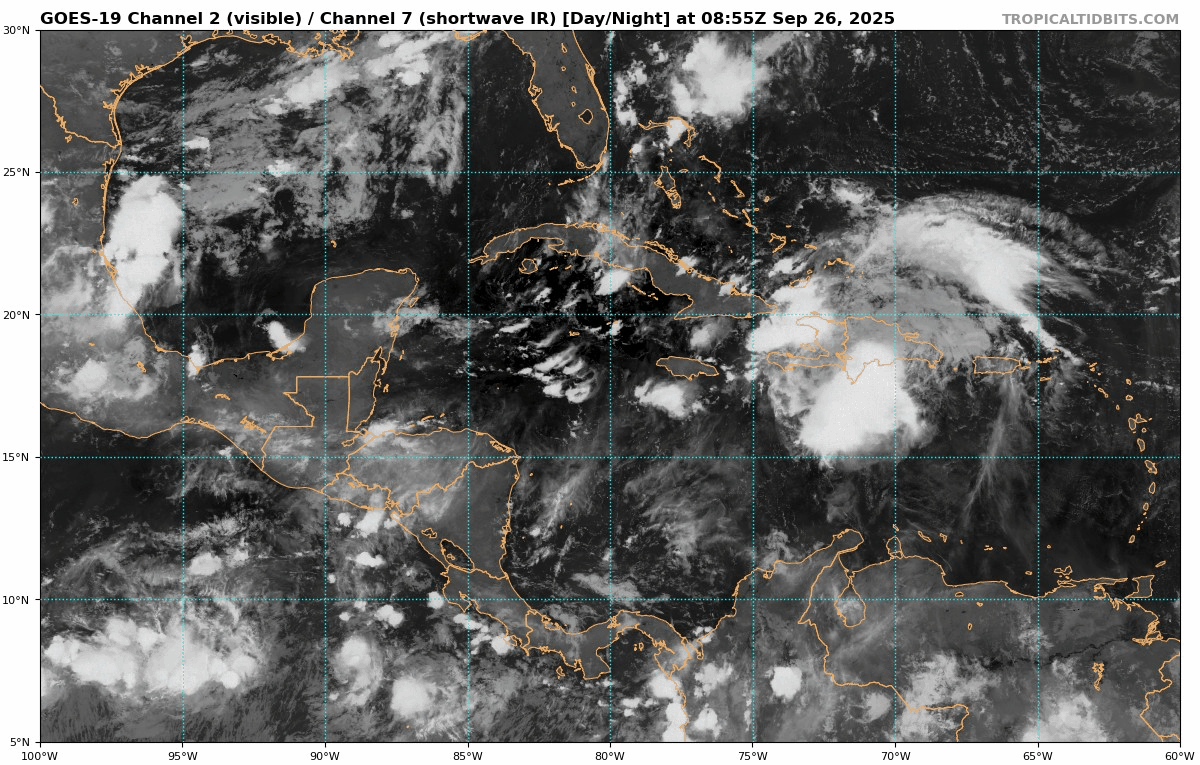
Still stuck in the Windward Passage / Tip of Haiti.
355K PV continues to erode with dropping shear.
Strong convection firing just south of the LLC
https://rammb-data.cira.colostate.edu/t ... 0_swhr.gif
https://rammb-data.cira.colostate.edu/t ... 260658.png
https://rammb-data.cira.colostate.edu/t ... 260658.png
355K PV continues to erode with dropping shear.
Strong convection firing just south of the LLC
https://rammb-data.cira.colostate.edu/t ... 0_swhr.gif
https://rammb-data.cira.colostate.edu/t ... 260658.png
https://rammb-data.cira.colostate.edu/t ... 260658.png
1 likes
-
cycloneye
- Admin
- Posts: 149719
- Age: 69
- Joined: Thu Oct 10, 2002 10:54 am
- Location: San Juan, Puerto Rico
Re: NATL: INVEST 94L - Discussion (80/90)
Tropical Weather Outlook
NWS National Hurricane Center Miami FL
800 AM EDT Fri Sep 26 2025
Southwestern Atlantic (AL94):
Showers and thunderstorms continue to show signs of organization in
association with a tropical wave located near Hispaniola, the
Turks and Caicos Islands, and eastern Cuba. An area of low pressure
is expected to form along the wave by tonight when it moves near the
southeast Bahamas. This low is expected to become a tropical
depression when it is in the vicinity of the central and northwest
Bahamas over the weekend, and then track northwestward or northward
over the southwestern Atlantic.
Regardless of development, heavy rains and gusty winds are ongoing
in the Dominican Republic, Haiti, and the Turks and Caicos Islands,
and are likely to spread across the Bahamas and eastern Cuba during
the next day or two. Interests in all of these areas should monitor
the progress of the system. While there remains considerable
uncertainty in the long-range track and intensity of the system,
there is a significant risk of wind, rainfall, and storm surge
impacts for a portion of the southeast U.S. coast early next week.
Interests in this area should also monitor the progress of the
system.
* Formation chance through 48 hours...high...80 percent.
* Formation chance through 7 days...high...90 percent.
Forecaster Cangialosi
0 likes
Visit the Caribbean-Central America Weather Thread where you can find at first post web cams,radars
and observations from Caribbean basin members Click Here
and observations from Caribbean basin members Click Here
-
wxman57

- Moderator-Pro Met

- Posts: 23175
- Age: 68
- Joined: Sat Jun 21, 2003 8:06 pm
- Location: Houston, TX (southwest)
Re: NATL: INVEST 94L - Discussion (80/90)
Word from the NHC is that they will not start PTC advisories unless there is a coherent low-level vortex. I'd like to have that luxury. Model trend is for development then a stall offshore the Carolinas next week. Some models stall it far enough offshore such that the Carolinas don't get much wind or rain at all. A few still move it inland. This is a very low confidence forecast.
11 likes
Re: NATL: INVEST 94L - Discussion (80/90)
Interesting interaction I just saw on the latest GFS run.
As 94L gets over the Gulf Stream on approach to South Carolina, Humberto will be feeding it high-TPW / high-CAPE air.
Looks like the feed is all the way from the EPAC thru Panama.
Looks like the west-side of 94L will be disrupted from a negative-tilted trough extending from North Florida to Tennesse where a cutoff low will be located.
The east-side of the storm however will be enhanced from an Upper-Level Low positioned at 33N 65W, just north of Humberto.
1 likes
-
cycloneye
- Admin
- Posts: 149719
- Age: 69
- Joined: Thu Oct 10, 2002 10:54 am
- Location: San Juan, Puerto Rico
Re: NATL: INVEST 94L - Discussion (80/90)
GCANE wrote:Interesting interaction I just saw on the latest GFS run.
As 94L gets over the Gulf Stream on approach to South Carolina, Humberto will be feeding it high-TPW / high-CAPE air.
Looks like the feed is all the way from the EPAC thru Panama.
Looks like the west-side of 94L will be disrupted from a negative-tilted trough extending from North Florida to Tennesse where a cutoff low will be located.
The east-side of the storm however will be enhanced from an Upper-Level Low positioned at 33N 65W, just north of Humberto.
Many moving parts and that is why this will be a complex next 2-3 days.
2 likes
Visit the Caribbean-Central America Weather Thread where you can find at first post web cams,radars
and observations from Caribbean basin members Click Here
and observations from Caribbean basin members Click Here
-
Blown Away

- S2K Supporter

- Posts: 10253
- Joined: Wed May 26, 2004 6:17 am
Re: NATL: INVEST 94L - Discussion (80/90)
Low level clouds continue moving W towards E Cuba and if 94L continues W it will delay moving N and may be more influenced by Humberto.
0 likes
Hurricane Eye Experience: David 79, Irene 99, Frances 04, Jeanne 04, Wilma 05… Hurricane Brush Experience: Andrew 92, Erin 95, Floyd 99, Matthew 16, Irma 17, Ian 22, Nicole 22…
-
cycloneye
- Admin
- Posts: 149719
- Age: 69
- Joined: Thu Oct 10, 2002 10:54 am
- Location: San Juan, Puerto Rico
Re: NATL: INVEST 94L - Discussion (80/90)
NE tip of Cuba at 12z.


AL, 94, 2025092612, , BEST, 0, 203N, 740W, 25, 1009, DB
1 likes
Visit the Caribbean-Central America Weather Thread where you can find at first post web cams,radars
and observations from Caribbean basin members Click Here
and observations from Caribbean basin members Click Here
-
TampaWxLurker
- Tropical Storm

- Posts: 196
- Joined: Thu Aug 01, 2024 8:20 am
Re: NATL: INVEST 94L - Discussion (80/90) 12z Best Track at NE tip of Cuba
Track and location to this point look similar to Hurricane David 1979. Minus the intensity.
1 likes
-
Blown Away
- S2K Supporter
- Posts: 10253
- Joined: Wed May 26, 2004 6:17 am
Re: NATL: INVEST 94L - Discussion (80/90)
It’s starting to stack, the low and high level clouds moving in tandem.
1 likes
Hurricane Eye Experience: David 79, Irene 99, Frances 04, Jeanne 04, Wilma 05… Hurricane Brush Experience: Andrew 92, Erin 95, Floyd 99, Matthew 16, Irma 17, Ian 22, Nicole 22…
-
cycloneye
- Admin
- Posts: 149719
- Age: 69
- Joined: Thu Oct 10, 2002 10:54 am
- Location: San Juan, Puerto Rico
Re: NATL: INVEST 94L - Discussion (80/90)
Things are slowly comming together now.

1 likes
Visit the Caribbean-Central America Weather Thread where you can find at first post web cams,radars
and observations from Caribbean basin members Click Here
and observations from Caribbean basin members Click Here
Re: NATL: INVEST 94L - Discussion (80/90)
Looks like the top of the wave axis is just NW of Great Inagua.
Much stronger convection on the west side of the axis over water.
Could get closed off by time recon takes a look.
Much stronger convection on the west side of the axis over water.
Could get closed off by time recon takes a look.
0 likes
-
TomballEd
- Category 5

- Posts: 1321
- Age: 62
- Joined: Wed Aug 16, 2023 4:52 pm
- Location: Spring/Klein area, not Tomball
Re: NATL: INVEST 94L - Discussion (80/90)
wxman57 wrote:Word from the NHC is that they will not start PTC advisories unless there is a coherent low-level vortex. I'd like to have that luxury. Model trend is for development then a stall offshore the Carolinas next week. Some models stall it far enough offshore such that the Carolinas don't get much wind or rain at all. A few still move it inland. This is a very low confidence forecast.
I thought the whole point of the PTC was to allow watches and warnings from a system with high probability of development close to land. I thought the whole point was to allow advisories before the system develops. But maybe I am wrong.
4 likes
-
Coolcruiseman
- Tropical Depression

- Posts: 97
- Age: 52
- Joined: Wed Sep 21, 2022 8:10 pm
- Location: Melbourne, FL
Re: NATL: INVEST 94L - Discussion (80/90)
Many complexities at play. NWS Melbourne reminding us to monitor this system and ensure emergency plan is ready and supplies in place if needed due to “significant level of uncertainty relative to potential track and intensity”.
And NWS Jax has a preparedness timeline reminder of what to do 3-5 days out with the currently expected close pass. And they mention this in the forecaster discussion:
And NWS Jax has a preparedness timeline reminder of what to do 3-5 days out with the currently expected close pass. And they mention this in the forecaster discussion:
Confidence has increased overall from low to moderate over the past 12-24 hours, as guidance is starting to come into better
agreement that the aforementioned upper low and retrograde motion will "pull" this disturbance towards the southeastern states
starting around Sunday Night as it retrogrades generally westward.
0 likes
-
wxman57
- Moderator-Pro Met
- Posts: 23175
- Age: 68
- Joined: Sat Jun 21, 2003 8:06 pm
- Location: Houston, TX (southwest)
Re: NATL: INVEST 94L - Discussion (80/90)
TomballEd wrote:wxman57 wrote:Word from the NHC is that they will not start PTC advisories unless there is a coherent low-level vortex. I'd like to have that luxury. Model trend is for development then a stall offshore the Carolinas next week. Some models stall it far enough offshore such that the Carolinas don't get much wind or rain at all. A few still move it inland. This is a very low confidence forecast.
I thought the whole point of the PTC was to allow watches and warnings from a system with high probability of development close to land. I thought the whole point was to allow advisories before the system develops. But maybe I am wrong.
Yeah, me too. Maybe they're looking at all the wild tracks in the models and just don't make a forecast yet. They have issued PTC advisories with only a tropical wave in the past. They don't appear to want to touch this one.
5 likes
-
MGC

- S2K Supporter
- Posts: 5941
- Joined: Sun Mar 23, 2003 9:05 pm
- Location: Pass Christian MS, or what is left.
Re: NATL: INVEST 94L - Discussion (80/90)
94L slowly getting better organized with broad cyclonic rotation observed centered near the Windward Passage. Expect more robust development once disturbance clears Greater Antilles and moves into the Bahamas. As others have noted a rather complex forecast. My current thinking is a Cat 2 impact along the Carolina coast with a 25% chance of OTS......MGC
3 likes
-
wzrgirl1

- S2K Supporter
- Posts: 1360
- Joined: Sat Sep 04, 2004 6:44 am
- Location: Pembroke Pines, Florida
Re: NATL: INVEST 94L - Discussion (80/90)
wxman57 wrote:TomballEd wrote:wxman57 wrote:Word from the NHC is that they will not start PTC advisories unless there is a coherent low-level vortex. I'd like to have that luxury. Model trend is for development then a stall offshore the Carolinas next week. Some models stall it far enough offshore such that the Carolinas don't get much wind or rain at all. A few still move it inland. This is a very low confidence forecast.
I thought the whole point of the PTC was to allow watches and warnings from a system with high probability of development close to land. I thought the whole point was to allow advisories before the system develops. But maybe I am wrong.
Yeah, me too. Maybe they're looking at all the wild tracks in the models and just don't make a forecast yet. They have issued PTC advisories with only a tropical wave in the past. They don't appear to want to touch this one.
At some point, something has to give in the not-so-distant future.
1 likes

Re: NATL: INVEST 94L - Discussion (80/90)
wzrgirl1 wrote:wxman57 wrote:TomballEd wrote:
I thought the whole point of the PTC was to allow watches and warnings from a system with high probability of development close to land. I thought the whole point was to allow advisories before the system develops. But maybe I am wrong.
Yeah, me too. Maybe they're looking at all the wild tracks in the models and just don't make a forecast yet. They have issued PTC advisories with only a tropical wave in the past. They don't appear to want to touch this one.
At some point, something has to give in the not-so-distant future.
Especially when the Bahamas is almost guaranteed to receive TS-force winds (unlike CONUS that has a chance to escape landfall), and within a much shorter window.
It would be one matter if the government of the Bahamas chose not to issue any warnings, but I don’t recall "the need to issue warnings" as a criteria for PTC advisories - isn't it more like "TS winds expected in 48 hours"?
2 likes
TC naming lists: retirements and intensity
Most aggressive Advisory #1's in North Atlantic (cr. kevin for starting the list)
Most aggressive Advisory #1's in North Atlantic (cr. kevin for starting the list)
Who is online
Users browsing this forum: No registered users and 64 guests