NATL: HUMBERTO - Remnants - Discussion

Moderator: S2k Moderators

Message
Author
zhukm29
Category 1
Category 1
Posts: 351
Joined: Tue Aug 28, 2018 2:37 pm

Re: NATL: HUMBERTO - Hurricane - Discussion

#461 Postby zhukm29 » Tue Sep 30, 2025 11:47 pm

Never seen a cone quite like this one:

Image
Image
7 likes   

Sciencerocks
Category 5
Category 5
Posts: 9781
Age: 39
Joined: Thu Jul 06, 2017 1:51 am

Re: NATL: HUMBERTO - Hurricane - Discussion

#462 Postby Sciencerocks » Wed Oct 01, 2025 1:54 am

Image
0 likes   

ryxn314
Tropical Low
Tropical Low
Posts: 12
Joined: Fri Dec 27, 2024 11:54 pm

Re: NATL: HUMBERTO - Hurricane - Discussion

#463 Postby ryxn314 » Wed Oct 01, 2025 8:31 am

Fun fact! Currently, Hurricane Humberto is the ONLY Atlantic Category 5 hurricane (out of 44) to not have a Wikipedia article.

If you count Pacific Category 5 hurricanes (4 out of 21 having no Wiki page), then Humberto joins Patsy (1959), Elida (2002), Hernan (2002), and Kristy (2024) as the only 5 (out of 65) Category 5 hurricanes without pages.
Last edited by ryxn314 on Wed Oct 01, 2025 9:53 am, edited 1 time in total.
2 likes   

ryxn314
Tropical Low
Tropical Low
Posts: 12
Joined: Fri Dec 27, 2024 11:54 pm

Re: NATL: HUMBERTO - Hurricane - Discussion

#464 Postby ryxn314 » Wed Oct 01, 2025 8:48 am

Looks like Humberto got eaten by Imelda after their dance! That's some praying mantis behavior right there :lol:
Last edited by ryxn314 on Wed Oct 01, 2025 9:52 am, edited 1 time in total.
3 likes   

MEANINGLESS_NUMBERS
Category 1
Category 1
Posts: 435
Joined: Mon Nov 02, 2020 1:43 pm

Re: NATL: HUMBERTO - Hurricane - Discussion

#465 Postby MEANINGLESS_NUMBERS » Wed Oct 01, 2025 9:35 am

ryxn314 wrote:Fun fact! Currently, Hurricane Humberto is the ONLY Atlantic Category 5 hurricane (out of 44) to not have a Wikipedia article.

If you count Pacific Category 5 hurricanes (4 out of 21 having no Wiki page), than Humberto joins Patsy (1959), Elida (2002), Hernan (2002), and Kristy (2024) as the only 5 (out of 65) Category 5 hurricanes without pages.

There is a draft: https://en.wikipedia.org/wiki/Draft:Hur ... erto_(2025)

Unclear whether the storms meets notability criteria though! Looked cool but didn't do anything.
2 likes   
Emily '87, Felix '95, Gert '99, Fabian '03, Humberto '19, Paulette '20, Teddy '20, Fiona '22, Lee '23, Ernesto '24, Humberto/Imelda '25

User avatar
cycloneye
Admin
Admin
Posts: 147749
Age: 69
Joined: Thu Oct 10, 2002 10:54 am
Location: San Juan, Puerto Rico

Re: NATL: HUMBERTO - Remnants - Discussion

#466 Postby cycloneye » Wed Oct 01, 2025 9:57 am

Bye. He did a good show.
6 likes   
Visit the Caribbean-Central America Weather Thread where you can find at first post web cams,radars
and observations from Caribbean basin members Click Here

ryxn314
Tropical Low
Tropical Low
Posts: 12
Joined: Fri Dec 27, 2024 11:54 pm

Re: NATL: HUMBERTO - Remnants - Discussion

#467 Postby ryxn314 » Wed Oct 01, 2025 10:04 am

He saved the Carolinas, then got ate!

Truly a legend, a gentle giant who minded his own business and then got slapped by Imelda.

Don't worry Humberto, no one compares to you, King.
4 likes   

User avatar
Teban54
Category 5
Category 5
Posts: 3524
Joined: Sat May 19, 2018 1:19 pm

Re: NATL: HUMBERTO - Remnants - Discussion

#468 Postby Teban54 » Wed Oct 01, 2025 11:26 am

Not often do you see strong CV hurricanes becoming remnants in the middle of the Atlantic (as opposed to transitioning to post-tropical at higher latitudes), much less a Cat 5.

Image
3 likes   

zhukm29
Category 1
Category 1
Posts: 351
Joined: Tue Aug 28, 2018 2:37 pm

Re: NATL: HUMBERTO - Hurricane - Discussion

#469 Postby zhukm29 » Wed Oct 01, 2025 6:41 pm

ryxn314 wrote:He saved the Carolinas, then got ate!

Truly a legend, a gentle giant who minded his own business and then got slapped by Imelda.

Don't worry Humberto, no one compares to you, King.


snowystar wrote:
zhukm29 wrote:
Hurricane2022 wrote:If we didn't have IMELDA in the Bahamas with its immense outflow now, we possibly would be facing an even stronger Hurricane Humberto in the coming days. What a shame :x
https://i.imgur.com/74MpydH.jpeg


Imelda first stealing Humberto’s recon, and now stealing Humberto’s second peak - spoiled sibling energy :lol:


Next she will steal Humberto's Tropical Storm Watch

A Tropical Storm Watch means that tropical storm conditions are
possible within the watch area, generally within 48 hours. This
Tropical Storm Watch may be replaced with a Hurricane Watch later
today due to Imelda.


Guess she ended up stealing Humberto's entire life force as well after pushing him into the frontal boundary lol :Can:

Pretty neat storm, looking forward to what they do during post-season reanalysis. Quite a blessing to get a true Cat 5 fish storm that didn't severely impact anyone at all (even Erin's precursor impacted the Cape Verde islands), and possibly one of the strongest NATL storms in recent history (but we'll never know without recon).
7 likes   

CrazyC83
Professional-Met
Professional-Met
Posts: 34127
Joined: Tue Mar 07, 2006 11:57 pm
Location: Deep South, for the first time!

Re: NATL: HUMBERTO - Remnants - Discussion

#470 Postby CrazyC83 » Wed Oct 01, 2025 8:41 pm

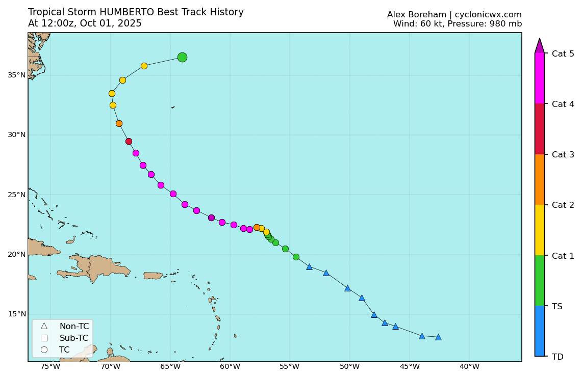
As far as Humberto's BT, here's how I would have it (unofficial):

AL082025, HUMBERTO, xx,
20250924, 0000, , LO, 17.2N, 50.2W, 25, 1008,
20250924, 0600, , LO, 18.1N, 51.8W, 30, 1007,
20250924, 1200, , TD, 18.9N, 53.3W, 30, 1006,
20250924, 1800, , TS, 19.0N, 54.5W, 35, 1004,
20250925, 0000, , TS, 19.8N, 55.4W, 45, 1002,
20250925, 0600, , TS, 20.4N, 56.1W, 45, 1001,
20250925, 1200, , TS, 21.0N, 56.5W, 50, 998,
20250925, 1800, , TS, 21.3N, 56.8W, 55, 995,
20250926, 0000, , TS, 21.7N, 56.9W, 60, 991,
20250926, 0600, , HU, 21.9N, 57.1W, 70, 983,
20250926, 1200, , HU, 22.2N, 57.4W, 85, 972,
20250926, 1800, , HU, 22.3N, 57.8W, 105, 953,
20250927, 0000, , HU, 22.3N, 58.4W, 120, 941,
20250927, 0600, , HU, 22.2N, 59.0W, 125, 937,
20250927, 1200, , HU, 22.5N, 59.7W, 125, 935,
20250927, 1800, , HU, 22.7N, 60.7W, 135, 926,
20250927, 2100, I, HU, 22.9N, 61.2W, 145, 918,
20250928, 0000, , HU, 23.1N, 61.6W, 140, 920,
20250928, 0600, , HU, 23.7N, 62.8W, 130, 926,
20250928, 1200, , HU, 24.3N, 63.8W, 120, 931,
20250928, 1800, , HU, 25.1N, 64.8W, 120, 929,
20250929, 0000, , HU, 25.8N, 65.8W, 120, 928,
20250929, 0600, , HU, 26.7N, 66.6W, 115, 934,
20250929, 1200, , HU, 27.5N, 67.3W, 115, 938,
20250929, 1800, , HU, 28.5N, 67.9W, 105, 948,
20250930, 0000, , HU, 29.6N, 68.6W, 90, 961,
20250930, 0600, , HU, 31.0N, 69.3W, 75, 972,
20250930, 1200, , HU, 32.4N, 69.8W, 70, 977,
20250930, 1800, , HU, 33.5N, 69.8W, 65, 979,
20251001, 0000, , HU, 34.6N, 69.0W, 65, 980,
20251001, 0600, , TS, 35.8N, 67.2W, 60, 982,
20251001, 1200, , EX, 36.7N, 64.1W, 55, 983,

* Genesis is moved up slightly. As is typical, the early life is smoothed out.
* The rapid intensification is adjusted slightly. My estimate is the peak intensity was at a non-synoptic time and a bit earlier, when it appeared that Humberto had the best presentation and was likely around T7.2. That supports an intensity of 145 kt. The pressure estimate of 918 mb was at that same time too, a blend of standard Dvorak and trends from later Recon.
* After peak intensity, most of the intensities are brought down a bit. They were generally a bit generous, and by the 29th, it is possible the 90% rule was not applicable as shear was increasing. That was despite a fairly low pressure - 928 mb when Recon first went in.
* Decay is moved up 6 hours with a brief extratropical period before the nearby trough and extratropical low overtook what was left of Humberto.
6 likes   

User avatar
Category5Kaiju
Category 5
Category 5
Posts: 4217
Joined: Thu Dec 24, 2020 12:45 pm
Location: Seattle

Re: NATL: HUMBERTO - Remnants - Discussion

#471 Postby Category5Kaiju » Wed Oct 01, 2025 10:12 pm

Humberto has also made history, in a sense: it's the first Atlantic Category 5 that didn't get a Wikipedia page. I mean, sure, we've had storms like Carol (1953), Esther (1961), Lorenzo, Lee, and Erin, but those storms, as a weak tropical storm or post-tropical cyclone in the first 4 cases and as a precursor in the case of Erin, did affect land to some degree and had impacts noteworthy enough that they deserved Wikipedia pages. Not Humberto. Arguably the Atlantic's first recorded Category 5 that also ended up as a "true" fish storm.

Edit: ah, I see, this was already mentioned several posts up
2 likes   
Unless explicitly stated, all info in my posts is based on my own opinions and observations. Tropical storms and hurricanes can be extremely dangerous. Do not think you can beat Mother Nature. Refer to an accredited weather research agency or meteorologist if you need to make serious decisions regarding an approaching storm.

User avatar
cycloneye
Admin
Admin
Posts: 147749
Age: 69
Joined: Thu Oct 10, 2002 10:54 am
Location: San Juan, Puerto Rico

Re: NATL: HUMBERTO - Remnants - Discussion

#472 Postby cycloneye » Thu Oct 02, 2025 5:16 am

Does anyone think the TCR post season report will have changes to have more time as a cat 5 when recon was not there?
3 likes   
Visit the Caribbean-Central America Weather Thread where you can find at first post web cams,radars
and observations from Caribbean basin members Click Here

MEANINGLESS_NUMBERS
Category 1
Category 1
Posts: 435
Joined: Mon Nov 02, 2020 1:43 pm

Re: NATL: HUMBERTO - Hurricane - Discussion

#473 Postby MEANINGLESS_NUMBERS » Thu Oct 02, 2025 12:22 pm

zhukm29 wrote:Never seen a cone quite like this one:

https://i.imgur.com/2sEBEo3.png


"I was in the pool!"
1 likes   
Emily '87, Felix '95, Gert '99, Fabian '03, Humberto '19, Paulette '20, Teddy '20, Fiona '22, Lee '23, Ernesto '24, Humberto/Imelda '25

User avatar
Hurricane2022
Category 5
Category 5
Posts: 1750
Joined: Tue Aug 23, 2022 11:38 pm
Location: Araçatuba, Brazil

Re: NATL: HUMBERTO - Remnants - Discussion

#474 Postby Hurricane2022 » Thu Oct 02, 2025 1:09 pm

cycloneye wrote:Does anyone think the TCR post season report will have changes to have more time as a cat 5 when recon was not there?

I think they're going to do something similar to what Kevin analyzed in the "Discussion of Intense Tropical Cyclones" thread, and I'll also admit that I would be a bit surprised if they're going to do a bigger update than that, given that they have missed other opportunities to make "corrections" to other strong hurricanes BT (e.g. Jova '23). But anyway, I'm very interested to see what they'll conclude about this in the TCR. I think that CrazyC83's analysis is the most reasonable one yet.
3 likes   
Sorry for the bad English sometimes...!
For reliable and detailed information for any meteorological phenomenon, please consult the National Hurricane Center, Joint Typhoon Warning Center , or your local Meteo Center.

--------

Una cvm Christo, pro Christo, et in Christo. Sit nomen Domini benedictvm.

MadaTheConquistador
Tropical Low
Tropical Low
Posts: 26
Age: 21
Joined: Thu Jan 09, 2025 4:58 pm

Re: NATL: HUMBERTO - Remnants - Discussion

#475 Postby MadaTheConquistador » Fri Oct 03, 2025 1:47 pm

I know it's been brought up before, but I think it's crazy how this is only the second time that we've had two C5s two years in a row. However, the it looks like Mother Nature has made the C5s this year seem to be much kinder than the ones last year (I don't want to jinx it though), especially Humberto. He saved the U.S. from another potentially destructive "I" named storm and the first C5 to be completely OTS as someone else mentioned. I think he deserves some kind of award.
4 likes   


Return to “2025”

Who is online

Users browsing this forum: Google Adsense [Bot] and 30 guests