
NATL: MELISSA - Aftermath - Discussion
Moderator: S2k Moderators
-
WaveBreaking

- Category 2

- Posts: 728
- Joined: Sun Jun 30, 2024 11:33 am
- Location: US
Re: NATL: MELISSA - Hurricane - Discussion
10 likes
I am NOT a professional meteorologist, so take all of my posts with a grain of salt. My opinions are mine and mine alone.

Re: NATL: MELISSA - Hurricane - Discussion
WaveBreaking wrote:https://i.imgur.com/ohOD6Sl.gif
2025 probably has the highest average eye quality on record. Every single MH this season was an eye candy to look at.
7 likes
TC naming lists: retirements and intensity
Most aggressive Advisory #1's in North Atlantic (cr. kevin for starting the list)
Most aggressive Advisory #1's in North Atlantic (cr. kevin for starting the list)
-
eastcoastFL

- Category 5

- Posts: 3996
- Age: 44
- Joined: Thu Apr 12, 2007 12:29 pm
- Location: Palm City, FL
Re: NATL: MELISSA - Hurricane - Discussion
The thunderstorms on the northern side of the storm continue to build in to the north on radar at a pretty impressive rate. Once she makes her turn the Jamaican coast is going to be under a relentless attack for quite some time.
0 likes
Personal Forecast Disclaimer:
The posts in this forum are NOT official forecast and should not be used as such. They are just the opinion of the poster and may or may not be backed by sound meteorological data. They are NOT endorsed by any professional institution or storm2k.org. For official information, please refer to the NHC and NWS products.
The posts in this forum are NOT official forecast and should not be used as such. They are just the opinion of the poster and may or may not be backed by sound meteorological data. They are NOT endorsed by any professional institution or storm2k.org. For official information, please refer to the NHC and NWS products.
-
Blown Away

- S2K Supporter

- Posts: 10253
- Joined: Wed May 26, 2004 6:17 am
Re: NATL: MELISSA - Hurricane - Discussion
Melissa is like a predator that has cornered prey and slowly circling around waiting to pounce on Jamaica… 
0 likes
Hurricane Eye Experience: David 79, Irene 99, Frances 04, Jeanne 04, Wilma 05… Hurricane Brush Experience: Andrew 92, Erin 95, Floyd 99, Matthew 16, Irma 17, Ian 22, Nicole 22…

Re: NATL: MELISSA - Hurricane - Discussion
The eye is starting to become a little asymmetrical again, perhaps another bit of dry air got in.
0 likes
Irene '11 Sandy '12 Hermine '16 5/15/2018 Derecho Fay '20 Isaias '20 Elsa '21 Henri '21 Ida '21
I am only a meteorology enthusiast who knows a decent amount about tropical cyclones. Look to the professional mets, the NHC, or your local weather office for the best information.
I am only a meteorology enthusiast who knows a decent amount about tropical cyclones. Look to the professional mets, the NHC, or your local weather office for the best information.
-
Sciencerocks
- Category 5
- Posts: 10193
- Age: 40
- Joined: Thu Jul 06, 2017 1:51 am

-
USTropics
- Professional-Met

- Posts: 2741
- Joined: Sun Aug 12, 2007 3:45 am
- Location: Florida State University
Re: NATL: MELISSA - Hurricane - Discussion
aspen wrote:The eye is starting to become a little asymmetrical again, perhaps another bit of dry air got in.
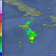
Again, this is mainly mid-level features we are looking at given distance, but I'm seeing a distinct moat developing on radar now (basically an inner eyewall -> moat/weak gradient -> outer eyewall forming):

This is normally a precursor to a full-on EWRC.
9 likes
-
WaveBreaking
- Category 2
- Posts: 728
- Joined: Sun Jun 30, 2024 11:33 am
- Location: US
Re: NATL: MELISSA - Hurricane - Discussion
Is Jamaica's met website broken for anyone else too? I was trying to see radar but barely anything's loaded.
0 likes
I am NOT a professional meteorologist, so take all of my posts with a grain of salt. My opinions are mine and mine alone.
-
USTropics
- Professional-Met
- Posts: 2741
- Joined: Sun Aug 12, 2007 3:45 am
- Location: Florida State University
Re: NATL: MELISSA - Hurricane - Discussion
WaveBreaking wrote:Is Jamaica's met website broken for anyone else too? I was trying to see radar but barely anything's loaded.
It's definitely chugging (understandably). Brian McNoldy has his radar loops here:
https://bmcnoldy.earth.miami.edu/tropics/radar/

What you can do here - https://metservice.gov.jm/daily-forecast/radar/
As long as you can get to the radar loop, go all the way to the last step (even if an image doesn't appear). Right click -> copy image address -> paste that in a different tab/window. That should load the latest available image.
1 likes
-
WaveBreaking
- Category 2
- Posts: 728
- Joined: Sun Jun 30, 2024 11:33 am
- Location: US
Re: NATL: MELISSA - Hurricane - Discussion
USTropics wrote:WaveBreaking wrote:Is Jamaica's met website broken for anyone else too? I was trying to see radar but barely anything's loaded.
It's definitely chugging (understandably). Brian McNoldy has his radar loops here:
https://bmcnoldy.earth.miami.edu/tropics/radar/
https://bmcnoldy.earth.miami.edu/tropics/melissa25/Melissa_25Oct25_jamaica_480.gif
What you can do here - https://metservice.gov.jm/daily-forecast/radar/
As long as you can get to the radar loop, go all the way to the last step. Right click -> copy image address -> paste that in a different tab/window. That should load the latest available image.
Thanks! The site's definitely not used to all the traffic it's getting atm.
0 likes
I am NOT a professional meteorologist, so take all of my posts with a grain of salt. My opinions are mine and mine alone.
Re: NATL: MELISSA - Hurricane - Discussion
WaveBreaking wrote:Is Jamaica's met website broken for anyone else too? I was trying to see radar but barely anything's loaded.
This mirror works well and doesnt have any gaps
https://flhurricane.com/imageanimator.php?960
2 likes
-
Hurricaneman

- Category 5
- Posts: 7404
- Age: 45
- Joined: Tue Aug 31, 2004 3:24 pm
- Location: central florida
Re: NATL: MELISSA - Hurricane - Discussion
Looks like an ERC is underway, will probably have a rather large eye after midnight
2 likes

Re: NATL: MELISSA - Hurricane - Discussion
If the AF plane's pressure extrap is accurate (medium if) Melissa might have deepened a bit since NOAA left, the last HDOB line reported 953.6mb still with 97kts FL wind and 105kt SFMR. Wait for the dropsonde to be sure. This was also in the weaker SE quad so winds might be up a bit.
Edit: 946.9mb in the eye, so maybe a few mb depending on how the extrap is calibrated relative to NOAA. There was a 114kt SFMR reading heading out of the eye, but only 111kt flight level winds. That's certainly not going to justify anything over 110kts.
Edit: 946.9mb in the eye, so maybe a few mb depending on how the extrap is calibrated relative to NOAA. There was a 114kt SFMR reading heading out of the eye, but only 111kt flight level winds. That's certainly not going to justify anything over 110kts.
Last edited by Travorum on Sun Oct 26, 2025 11:57 am, edited 2 times in total.
1 likes
-
WaveBreaking
- Category 2
- Posts: 728
- Joined: Sun Jun 30, 2024 11:33 am
- Location: US
Re: NATL: MELISSA - Hurricane - Discussion
Recon found 122 kt FL winds in the SE eyewall.

0 likes
I am NOT a professional meteorologist, so take all of my posts with a grain of salt. My opinions are mine and mine alone.
-
cycloneye

- Admin

- Posts: 149735
- Age: 69
- Joined: Thu Oct 10, 2002 10:54 am
- Location: San Juan, Puerto Rico
Re: NATL: MELISSA - Hurricane - Discussion
Minimum Extrap. Pressure: 946.9mb at 16:45z
4 likes
Visit the Caribbean-Central America Weather Thread where you can find at first post web cams,radars
and observations from Caribbean basin members Click Here
and observations from Caribbean basin members Click Here
-
cycloneye
- Admin
- Posts: 149735
- Age: 69
- Joined: Thu Oct 10, 2002 10:54 am
- Location: San Juan, Puerto Rico
Re: NATL: MELISSA - Hurricane - Discussion
Dropsonde is at 949 mbs.

3 likes
Visit the Caribbean-Central America Weather Thread where you can find at first post web cams,radars
and observations from Caribbean basin members Click Here
and observations from Caribbean basin members Click Here
Re: NATL: MELISSA - Hurricane - Discussion
Note that there's no double wind maxima on this eye pass, even though it doesn't strictly preclude the onset of an EWRC.
Edit: I may have spoken too soon, as the next set of data showed a small wind maximum albeit far removed from the eyewall.
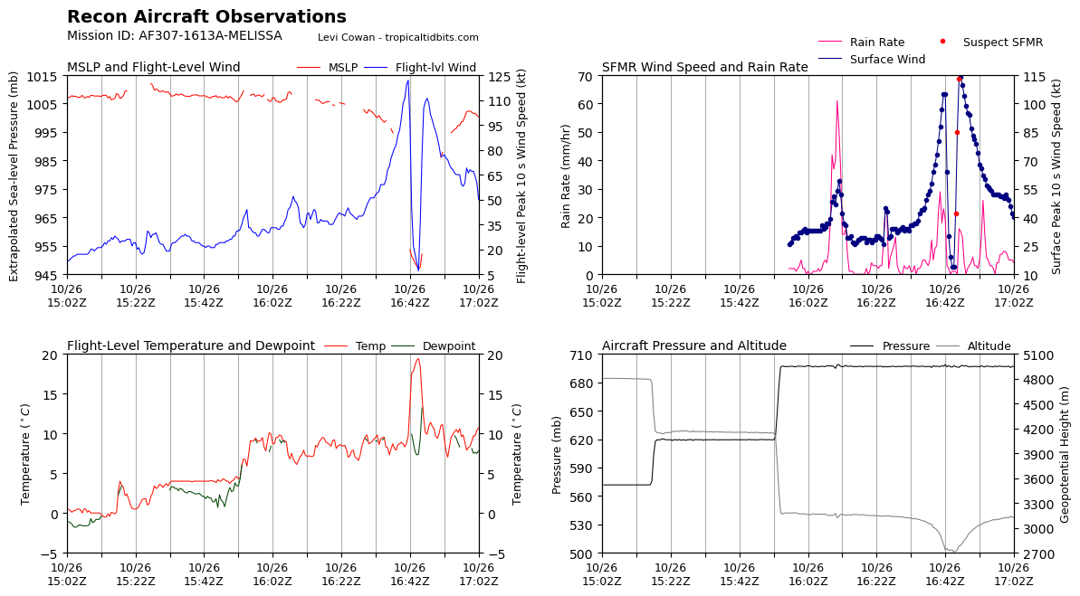
Edit: I may have spoken too soon, as the next set of data showed a small wind maximum albeit far removed from the eyewall.
3 likes
TC naming lists: retirements and intensity
Most aggressive Advisory #1's in North Atlantic (cr. kevin for starting the list)
Most aggressive Advisory #1's in North Atlantic (cr. kevin for starting the list)


Re: NATL: MELISSA - Hurricane - Discussion
Much like Rafael last year, if it weren't for recon observations, this could be treated as a much stronger storm. Subjective and objective satellite estimates (final T-numbers, not instantaneous!) have reached 7.0, and raw numbers have for the most part been hovering between 7.1 and 7.5 for upwards of 12 hours. Probably a number of factors inducing this upward bias in Dvorak intensity estimates.
4 likes
-
cycloneye
- Admin
- Posts: 149735
- Age: 69
- Joined: Thu Oct 10, 2002 10:54 am
- Location: San Juan, Puerto Rico
Re: NATL: MELISSA - Hurricane - Discussion
Eye is closed and is smaller.
VORTEX DATA MESSAGE AL132025
A. 26/16:45:00Z
B. 16.38 deg N 076.82 deg W
C. 700 mb 2680 m
D. 949 mb
E. 360 deg 26 kt
F. CLOSED
G. C8
H. 105 kt
I. 107 deg 8 nm 16:42:30Z
J. 211 deg 122 kt
K. 110 deg 9 nm 16:42:00Z
L. 114 kt
M. 276 deg 5 nm 16:47:00Z
N. 005 deg 111 kt
O. 282 deg 6 nm 16:47:30Z
P. 9 C / 3063 m
Q. 20 C / 3044 m
R. 7 C / NA
S. 12345 / 7
T. 0.02 / 3 nm
U. AF307 1613A MELISSA OB 05
MAX FL WIND 122 KT 110 / 9 NM 16:42:00Z
;
4 likes
Visit the Caribbean-Central America Weather Thread where you can find at first post web cams,radars
and observations from Caribbean basin members Click Here
and observations from Caribbean basin members Click Here
Who is online
Users browsing this forum: No registered users and 46 guests