NATL: MELISSA - Aftermath - Discussion
Moderator: S2k Moderators
-
cheezyWXguy

- Category 5

- Posts: 6282
- Joined: Mon Feb 13, 2006 12:29 am
- Location: Dallas, TX
Re: NATL: MELISSA - Hurricane - Discussion
-80c ring trying to thicken back toward the immediate eyewall. Almost feels like we’re watching it breathe as the ring expands and contracts.
8 likes


-
CrazyC83
- Professional-Met

- Posts: 34316
- Joined: Tue Mar 07, 2006 11:57 pm
- Location: Deep South, for the first time!
Re: NATL: MELISSA - Hurricane - Discussion
zzzh wrote:903mb 11kt.
Supports 902 mb. Looks like it is stabilizing.
4 likes
-
Hurricane2022

- Category 5
- Posts: 2070
- Joined: Tue Aug 23, 2022 11:38 pm
- Location: Araçatuba, Brazil
Re: NATL: MELISSA - Hurricane - Discussion
She may have stabilized at 155 kt/900 mb. I wouldn't rule a bit more strengthening but i'm thinking Meli has reached her maximum.
4 likes
Sorry for the bad English sometimes...!
For reliable and detailed information for any meteorological phenomenon, please consult the National Hurricane Center, Joint Typhoon Warning Center , or your local Meteo Center.
--------
ECCE OMNIA NOVA FACIAM (Ap 21,5).
For reliable and detailed information for any meteorological phenomenon, please consult the National Hurricane Center, Joint Typhoon Warning Center , or your local Meteo Center.
--------
ECCE OMNIA NOVA FACIAM (Ap 21,5).
-
mrbagyo

- Category 5
- Posts: 3973
- Age: 33
- Joined: Thu Apr 12, 2012 9:18 am
- Location: 14.13N 120.98E
- Contact:
Re: NATL: MELISSA - Hurricane - Discussion
dukeblue219 wrote:mrbagyo wrote:162 FL
Didn't enter the eye and veered SE
Sure they did. The winds went to near zero then they popped out.
ay yeah they did.
903 dropsonde
0 likes
The posts in this forum are NOT official forecast and should not be used as such. They are just the opinion of the poster and may or may not be backed by sound meteorological data. They are NOT endorsed by any professional institution or storm2k.org. For official information, please refer to RSMC, NHC and NWS products.

Re: NATL: MELISSA - Hurricane - Discussion
043630 1642N 07830W 6971 02271 //// +210 //// 279027 036 018 003 05
When we got 902.8mb earlier the height was 2308m @697.2mb
Now we are 2271m @ 697.1mb, J believe that also supports about a 900mb syrface pressure.
When we got 902.8mb earlier the height was 2308m @697.2mb
Now we are 2271m @ 697.1mb, J believe that also supports about a 900mb syrface pressure.
1 likes

Re: NATL: MELISSA - Hurricane - Discussion
Hurricane2022 wrote:She may have stabilized at 155 kt/900 mb. I wouldn't rule a bit more strengthening but i'm thinking Meli has reached her maximum.
This is a realistic & reasonable assessment, and could well be Melissa's peak on the TCR. There was no further deepening on the last pass, though, so my guess is we get 150 kt / 902 hPa on the 06z advisory, at most.
2 likes
Re: NATL: MELISSA - Hurricane - Discussion
Where’s Wxman by the way, I would love to hear his thoughts on Melissa?
5 likes

Re: NATL: MELISSA - Hurricane - Discussion
ADT reaching a CI of 8.5 @185 kts 
2025OCT28 034020 8.5 871.5 185.0 8.5 8.6 8.6 NO LIMIT OFF OFF OFF OFF 19.17 -81.36 EYE 15 IR 37.7 16.62 78.51 ARCHER GOES19 19.8
2025OCT28 041020 8.5 871.5 185.0 8.5 8.5 8.5 NO LIMIT OFF OFF OFF OFF 18.39 -81.03 EYE 14 IR 37.7 16.67 78.49 ARCHER GOES19 19.9
2025OCT28 041020 8.5 871.5 185.0 8.5 8.5 8.5 NO LIMIT OFF OFF OFF OFF 18.39 -81.03 EYE 14 IR 37.7 16.67 78.49 ARCHER GOES19 19.9
5 likes
ヤンデレ女が寝取られるているのを見たい!!!
ECMWF ensemble NWPAC plots: https://ecmwfensnwpac.imgbb.com/
Multimodel NWPAC plots: https://multimodelnwpac.imgbb.com/
GFS Ensemble NWPAC plots (16 & 35 day forecast): https://gefsnwpac.imgbb.com/
Plots updated automatically
ECMWF ensemble NWPAC plots: https://ecmwfensnwpac.imgbb.com/
Multimodel NWPAC plots: https://multimodelnwpac.imgbb.com/
GFS Ensemble NWPAC plots (16 & 35 day forecast): https://gefsnwpac.imgbb.com/
Plots updated automatically
-
Hurricane2022
- Category 5
- Posts: 2070
- Joined: Tue Aug 23, 2022 11:38 pm
- Location: Araçatuba, Brazil
Re: NATL: MELISSA - Hurricane - Discussion
CDO seems to be cooling a bit again 
3 likes
Sorry for the bad English sometimes...!
For reliable and detailed information for any meteorological phenomenon, please consult the National Hurricane Center, Joint Typhoon Warning Center , or your local Meteo Center.
--------
ECCE OMNIA NOVA FACIAM (Ap 21,5).
For reliable and detailed information for any meteorological phenomenon, please consult the National Hurricane Center, Joint Typhoon Warning Center , or your local Meteo Center.
--------
ECCE OMNIA NOVA FACIAM (Ap 21,5).

Re: NATL: MELISSA - Hurricane - Discussion
If Melissa can stabilize in its current state until landfall in Jamaica - and that's a pretty big if - it can easily break records for most intense landfalling pressures.
Wikipedia has a list of pressure records by peak and landfall. Maintaining its current, official pressure of 903 mb would make Melissa the 4th most intense landfall, only behind 1935 Labor Day (892 mb), Gilbert (900 mb) and Camille (900 mb).
In all likelihood, some weaking is quite likely. But Melissa can weaken all the way up to 918 mb (a difference of 15 mb from now) and still join the list of the 10 most intense landfalls.
In the event that Melissa somehow strengthens further and achieves sub-900 until landfall... Not only would it become the 7th recorded sub-900 mb storm anywhere, but it would also become only the second ever sub-900 mb landfall.
Note: The screenshot below is sorted by landfall pressure, so the peak pressure column is unsorted.
Last edited by Teban54 on Tue Oct 28, 2025 12:22 am, edited 1 time in total.
6 likes
TC naming lists: retirements and intensity
Most aggressive Advisory #1's in North Atlantic (cr. kevin for starting the list)
Most aggressive Advisory #1's in North Atlantic (cr. kevin for starting the list)
Re: NATL: MELISSA - Hurricane - Discussion
Melissa broke it’s dry eye record again, and then again shortly after.
6 likes
Re: NATL: MELISSA - Hurricane - Discussion
AF301 has left.
Next recon schedules, all in EDT:

Next recon schedules, all in EDT:
- AF: Departure 5am, fix 7:30 am
- NOAA: Departure 4am, fix 8am
4 likes
TC naming lists: retirements and intensity
Most aggressive Advisory #1's in North Atlantic (cr. kevin for starting the list)
Most aggressive Advisory #1's in North Atlantic (cr. kevin for starting the list)
Re: NATL: MELISSA - Hurricane - Discussion

8 likes
TC naming lists: retirements and intensity
Most aggressive Advisory #1's in North Atlantic (cr. kevin for starting the list)
Most aggressive Advisory #1's in North Atlantic (cr. kevin for starting the list)
-
WaveBreaking

- Category 2

- Posts: 727
- Joined: Sun Jun 30, 2024 11:33 am
- Location: US
Re: NATL: MELISSA - Hurricane - Discussion
Another one of my homemade GeoColor images

9 likes
I am NOT a professional meteorologist, so take all of my posts with a grain of salt. My opinions are mine and mine alone.
-
SFLcane

- S2K Supporter

- Posts: 10281
- Age: 48
- Joined: Sat Jun 05, 2010 1:44 pm
- Location: Lake Worth Florida
Re: NATL: MELISSA - Hurricane - Discussion
Nothing short of gut wrenching to see this unfold just seeing some of those hafs model solutions come to realization. My sincere prayers to those in the path of this generational storm. Some areas were this thing hits will be unrecognizable. Wind gusts in higher elevations could easily top 200 mph!
4 likes
-
HurricaneRyan
- Category 3

- Posts: 847
- Age: 32
- Joined: Sun Dec 05, 2010 3:05 pm
Re: NATL: MELISSA - Hurricane - Discussion
I don't see this weakening enough to get below Category 5 when it hits Jamaica.
Pray for Jamaica.
Pray for Jamaica.
1 likes
Kay '22 Hilary '23
-
grapealcoholic
- Category 2
- Posts: 703
- Joined: Tue Aug 10, 2021 3:26 pm
Re: NATL: MELISSA - Hurricane - Discussion
back to deepening.. cloud tops gradient/contours getting smoother
895 next pass
she's going to bottom out -- close to mpi (sub 880)
895 next pass
she's going to bottom out -- close to mpi (sub 880)
0 likes
-
mrbagyo
- Category 5
- Posts: 3973
- Age: 33
- Joined: Thu Apr 12, 2012 9:18 am
- Location: 14.13N 120.98E
- Contact:
Re: NATL: MELISSA - Hurricane - Discussion
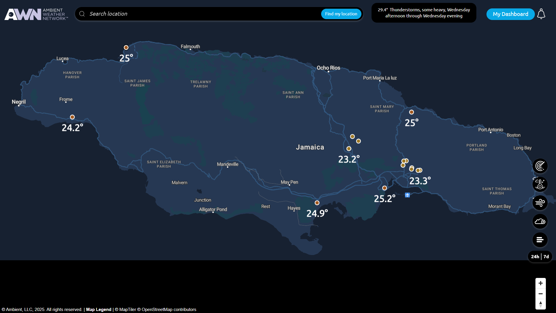
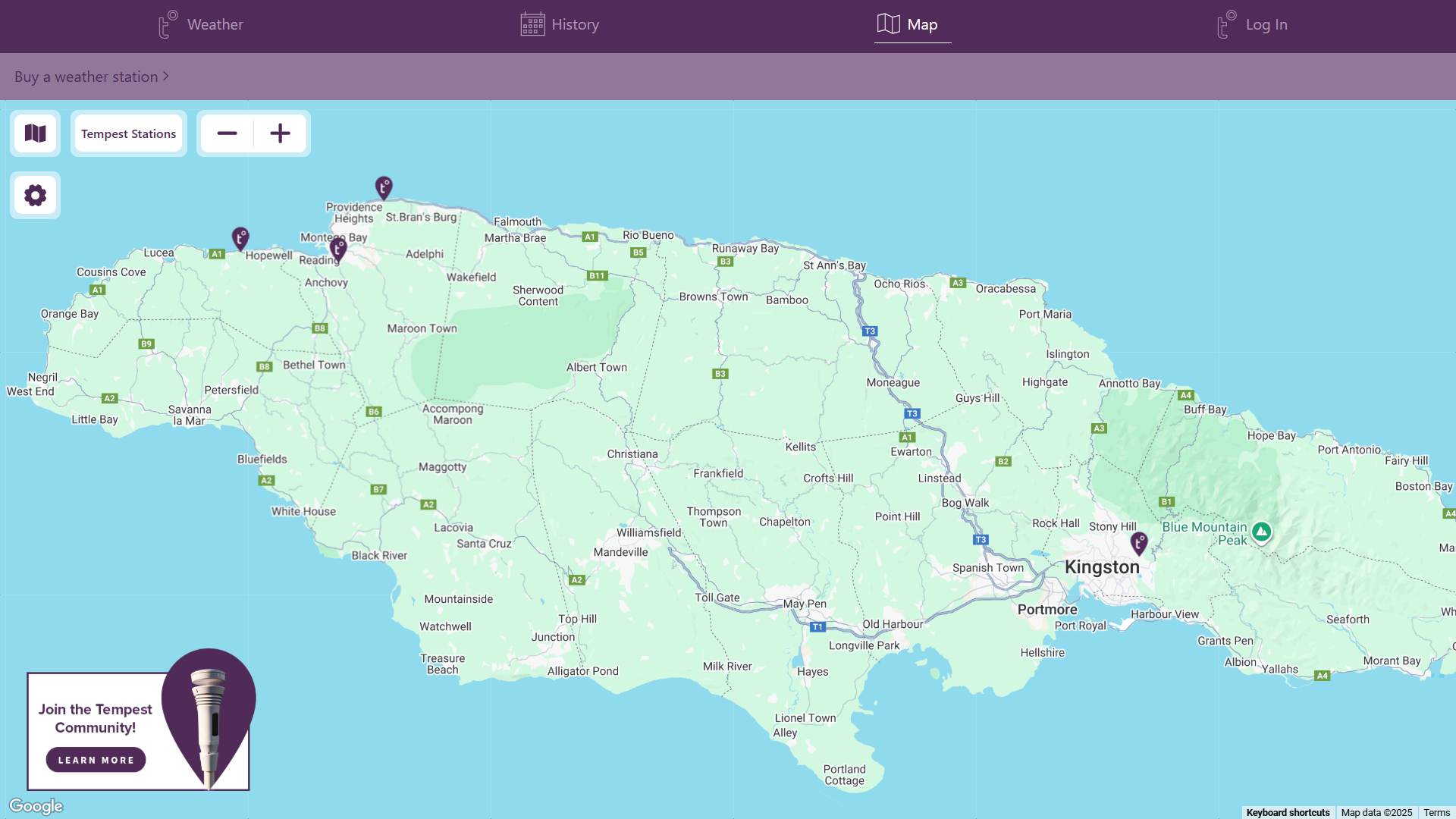
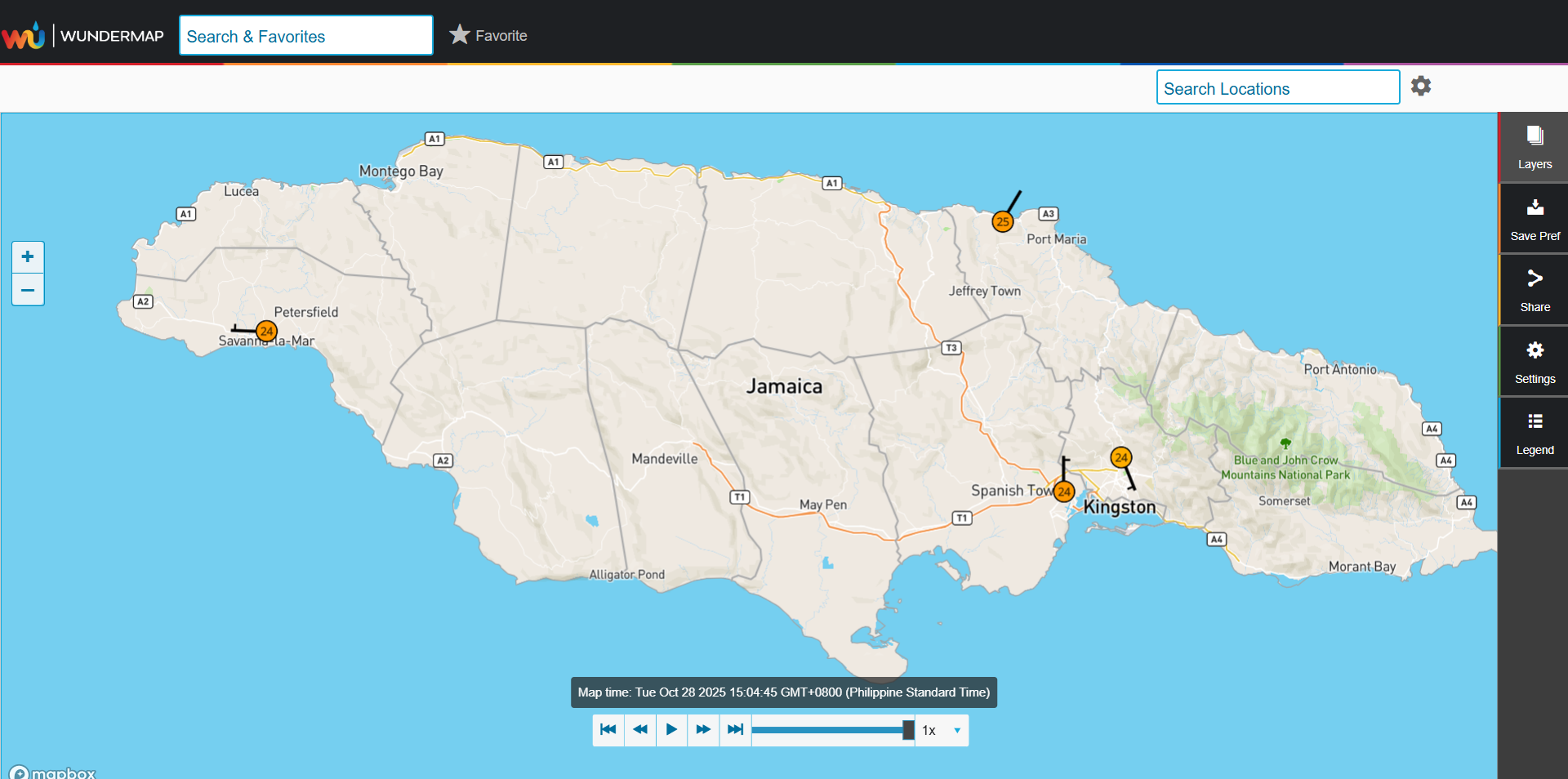
AWS are more numerous on the Eastern Part of Jamaica

0 likes
The posts in this forum are NOT official forecast and should not be used as such. They are just the opinion of the poster and may or may not be backed by sound meteorological data. They are NOT endorsed by any professional institution or storm2k.org. For official information, please refer to RSMC, NHC and NWS products.
Who is online
Users browsing this forum: No registered users and 78 guests