NATL: MELISSA - Aftermath - Discussion
Moderator: S2k Moderators

Re: NATL: MELISSA - Hurricane - Discussion
It’s going to be quite close for recon before landfall. And while looks can be deceiving, Melissa looks like she may well be intensifying…
0 likes

Re: NATL: MELISSA - Hurricane - Discussion
Melissa’s position seems to be about 1 hr ahead of the 06z HAFS-A, so landfall is probably going to be around 14z (10am). Hoping recon can get there in time.
If there’s the tiniest silver lining to any of this, at least Melissa isn’t a nighttime landfall.
If there’s the tiniest silver lining to any of this, at least Melissa isn’t a nighttime landfall.
2 likes
Irene '11 Sandy '12 Hermine '16 5/15/2018 Derecho Fay '20 Isaias '20 Elsa '21 Henri '21 Ida '21
I am only a meteorology enthusiast who knows a decent amount about tropical cyclones. Look to the professional mets, the NHC, or your local weather office for the best information.
I am only a meteorology enthusiast who knows a decent amount about tropical cyclones. Look to the professional mets, the NHC, or your local weather office for the best information.

Re: NATL: MELISSA - Hurricane - Discussion
About 80 more minutes until recon should be at the center of Melissa. If Melissa's current movement holds it should be around 17.50N/78.15W so recon should still be there well before landfall and might even be able to perform 2 passes before landfall.
2 likes

Re: NATL: MELISSA - Hurricane - Discussion
Recon is probably 2 hours away so I think we'll have time for a pass or two before landfall. The NOAA plane coming from FL however? Think that'll be too late now. Still good to get some data though
0 likes
Re: NATL: MELISSA - Hurricane - Discussion
Lightning is really exploding in the eyewall, concurrent with continued smoothing on IR. She very well may end up intensifying right up to landfall like many of the recent HAFS runs were predicting. I guess we'll see when recon arrives.
1 likes

Re: NATL: MELISSA - Hurricane - Discussion
Hypercane_Kyle wrote:It's hard to tell for sure but just looking at satellite I think Melissa is moving faster than expected. We may be looking at a landfall before 9-10am.
Core winds will be reaching Black river this morning so people would have to evacuate WNW to concrete high ground shelter in Montego bay now or shelter in place. Landfall this afternoon.
0 likes


Re: NATL: MELISSA - Hurricane - Discussion
kevin wrote:About 80 more minutes until recon should be at the center of Melissa. If Melissa's current movement holds it should be around 17.50N/78.15W so recon should still be there well before landfall and might even be able to perform 2 passes before landfall.
I get 17.4-17.5N and 78.12W based on its movement between 5:55z (16.9N/78.5W) and 10:45z (17.3N/78.2W). Even assuming it’s a little faster, it should still be off the coast when recon arrives.
0 likes
Irene '11 Sandy '12 Hermine '16 5/15/2018 Derecho Fay '20 Isaias '20 Elsa '21 Henri '21 Ida '21
I am only a meteorology enthusiast who knows a decent amount about tropical cyclones. Look to the professional mets, the NHC, or your local weather office for the best information.
I am only a meteorology enthusiast who knows a decent amount about tropical cyclones. Look to the professional mets, the NHC, or your local weather office for the best information.
-
TheHurricaneGod
- Tropical Storm

- Posts: 165
- Age: 23
- Joined: Thu Apr 16, 2020 6:19 pm
- Location: Fort Lauderdale
Re: NATL: MELISSA - Hurricane - Discussion
michelinj wrote:Latest WV eye temp is -3.39C. Warmest yet
-3.1C!
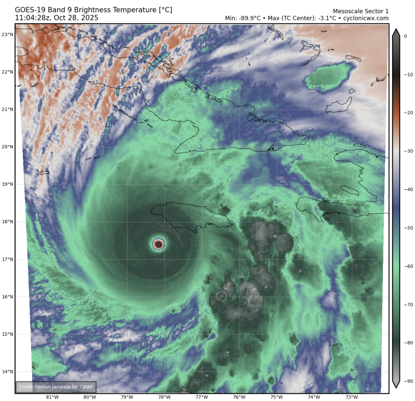
Edit: Up to -3.1C again just now.
9 likes

Re: NATL: MELISSA - Hurricane - Discussion
Looks like the eye is growing larger? I thought they usually constricted before landfall
0 likes
-
Hurricane2022

- Category 5

- Posts: 2064
- Joined: Tue Aug 23, 2022 11:38 pm
- Location: Araçatuba, Brazil
Re: NATL: MELISSA - Hurricane - Discussion
https://x.com/TheSteveCop/status/1983126666932109425
https://x.com/PettusWX/status/1983130691404480557
https://x.com/PettusWX/status/1983130691404480557
4 likes
Sorry for the bad English sometimes...!
For reliable and detailed information for any meteorological phenomenon, please consult the National Hurricane Center, Joint Typhoon Warning Center , or your local Meteo Center.
--------
ECCE OMNIA NOVA FACIAM (Ap 21,5).
For reliable and detailed information for any meteorological phenomenon, please consult the National Hurricane Center, Joint Typhoon Warning Center , or your local Meteo Center.
--------
ECCE OMNIA NOVA FACIAM (Ap 21,5).
Re: NATL: MELISSA - Hurricane - Discussion
ATDoel wrote:Looks like the eye is growing larger? I thought they usually constricted before landfall
I think it's due to completion of an eyewall merger this morning, unfortunately probably means it's strengthening again.
0 likes
-
MEANINGLESS_NUMBERS
- Category 2

- Posts: 503
- Joined: Mon Nov 02, 2020 1:43 pm
Re: NATL: MELISSA - Hurricane - Discussion
TheHurricaneGod wrote:michelinj wrote:Latest WV eye temp is -3.39C. Warmest yet
-3.1C! https://media.discordapp.net/attachments/1083741758648766484/1432687267851407450/goes19_g19meso1_wv_20251028110428.png?ex=6901f57e&is=6900a3fe&hm=1b17ca0e0c0554449fef06d73d6534e80f0d2eab47bb90179f29e6b64e70f1d3&=&format=webp&quality=lossless&width=853&height=824
Edit: Up to -3.1C again just now.
This is a historically intense storm. For landfall to be happening at its absolute peak is so unfortunate
2 likes
Emily '87, Felix '95, Gert '99, Fabian '03, Humberto '19, Paulette '20, Teddy '20, Fiona '22, Lee '23, Ernesto '24, Humberto/Imelda '25

Re: NATL: MELISSA - Hurricane - Discussion
C’mon recon… 
0 likes
Igor 2010, Sandy 2012, Fay 2014, Gonzalo 2014, Joaquin 2015, Nicole 2016, Humberto 2019, Imelda 2025
I am only a tropical weather enthusiast. My predictions are not official and may or may not be backed by sound meteorological data. For official information, please refer to the NHC and NWS products.
I am only a tropical weather enthusiast. My predictions are not official and may or may not be backed by sound meteorological data. For official information, please refer to the NHC and NWS products.
Re: NATL: MELISSA - Hurricane - Discussion
ATDoel wrote:Looks like the eye is growing larger? I thought they usually constricted before landfall
The eye was contracting late last night/early this morning, but over the past few hours seems to have stabilized if not outright expanded. My thought is Melissa underwent an eyewall meld in the early morning hours, and recently has stabilized following this, and may now even be strengthening again.
1 likes
Re: NATL: MELISSA - Hurricane - Discussion
MEANINGLESS_NUMBERS wrote:TheHurricaneGod wrote:michelinj wrote:Latest WV eye temp is -3.39C. Warmest yet
-3.1C! https://media.discordapp.net/attachments/1083741758648766484/1432687267851407450/goes19_g19meso1_wv_20251028110428.png?ex=6901f57e&is=6900a3fe&hm=1b17ca0e0c0554449fef06d73d6534e80f0d2eab47bb90179f29e6b64e70f1d3&=&format=webp&quality=lossless&width=853&height=824
Edit: Up to -3.1C again just now.
This is a historically intense storm. For landfall to be happening at its absolute peak is so unfortunate
I think, given its satellite appearance and landfall near peak intensity, that Melissa will be referred to as the “Haiyan of the Atlantic” in years to come.
1 likes
Igor 2010, Sandy 2012, Fay 2014, Gonzalo 2014, Joaquin 2015, Nicole 2016, Humberto 2019, Imelda 2025
I am only a tropical weather enthusiast. My predictions are not official and may or may not be backed by sound meteorological data. For official information, please refer to the NHC and NWS products.
I am only a tropical weather enthusiast. My predictions are not official and may or may not be backed by sound meteorological data. For official information, please refer to the NHC and NWS products.
-
grapealcoholic
- Category 2
- Posts: 703
- Joined: Tue Aug 10, 2021 3:26 pm
Re: NATL: MELISSA - Hurricane - Discussion
best the storm has ever looked
next couple hours will be interesting
next couple hours will be interesting
1 likes
-
Hypercane_Kyle

- Category 5
- Posts: 3465
- Joined: Sat Mar 07, 2015 7:58 pm
- Location: Cape Canaveral, FL
Re: NATL: MELISSA - Hurricane - Discussion
If there was an EWRC last night, it appears to have finished at the worst moment - Melissa appears to be making one final push for peak intensity. CDO temps aren't quite as cool but it is much more round with the eye as clear as it's ever been.

6 likes
My posts are my own personal opinion, defer to the National Hurricane Center (NHC) and other NOAA products for decision making during hurricane season.
Re: NATL: MELISSA - Hurricane - Discussion
Eye does appear to be growing before landfall.
This is the most intense lightning rate I have seen so far.
https://www.weathernerds.org/satellite/ ... itgefs=Off
This is the most intense lightning rate I have seen so far.
https://www.weathernerds.org/satellite/ ... itgefs=Off
0 likes
Re: NATL: MELISSA - Hurricane - Discussion
Hypercane_Kyle wrote:If there was an EWRC last night, it appears to have finished at the worst moment - Melissa appears to be making one final push for peak intensity. CDO temps aren't quite as cool but it is much more round with the eye as clear as it's ever been.
https://i.imgur.com/B2P3sF7.png
The sun is coming up at the moment and probably causing that slightly less cool CDO, no reflection on the storm I'd imagine, unfortunately
1 likes
Who is online
Users browsing this forum: No registered users and 57 guests