2026 Indicators: SST's, MSLP, Shear, SAL, Steering, Instability (Day 16+ Climate Models)

This is the general tropical discussion area. Anyone can take their shot at predicting a storms path.

Moderator: S2k Moderators

Forum rules

The posts in this forum are NOT official forecasts and should not be used as such. They are just the opinion of the poster and may or may not be backed by sound meteorological data. They are NOT endorsed by any professional institution or STORM2K. For official information, please refer to products from the National Hurricane Center and National Weather Service.

Help Support Storm2K
Message
Author
User avatar
cycloneye
Admin
Admin
Posts: 148941
Age: 69
Joined: Thu Oct 10, 2002 10:54 am
Location: San Juan, Puerto Rico

Re: 2026 Indicators: SST's, MSLP, Shear, SAL, Steering, Instability (Day 16+ Climate Models)

#41 Postby cycloneye » Mon Jan 19, 2026 7:38 pm

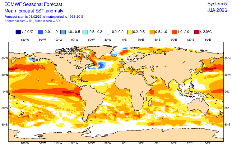
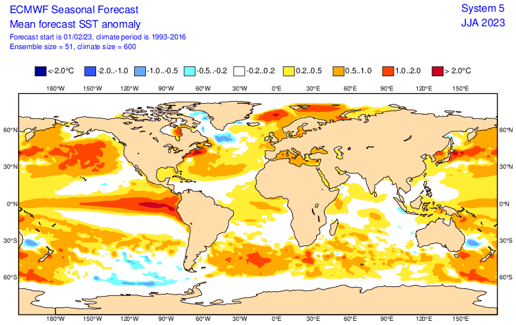
jconsor wrote:Hi, good question. I discussed in the post above yours that most C3S/Copernicus models favor an Atlantic Nino developing this spring. Looks like it could develop significantly earlier based on the recent SST changes (which you posted) and the ECMWF low level wind forecasts through Feb.

[url]https://i.ibb.co/xKD0rP5n/20260119193529-493c6c11465c6b61d080d2512736015b0ffc6081.png [/url]
[url]https://i.ibb.co/pv4JxxQb/20260119193542-9257e48bfba5c722ad1f3a51ed0384f4d6a03c81.png [/url]
[url]https://i.ibb.co/35ytr00Y/20260119193555-ba2077c3cfdff9e5df9b90a7085114b20c761acb.png [/url]
[url]https://i.ibb.co/CGxnZjW/20260119193611-f916dab6a62e8c6ff63e98a53a5ea65405a63b41.png [/url]
[url]https://i.ibb.co/j9Rmf1CN/20260119193621-f256ef145f687c149570fae6f2c072f617fcb234.png [/url]
[url]https://i.ibb.co/WvVSjyY6/eps-0-N-hov-uanom-2026011900.png [/url]

cycloneye wrote:Is early but have question about the Tropical Atlantic/South Atlantic. How the members see where things will go in terms of Atlantic Niño or Niña down the road?

https://i.imgur.com/YyB9FHK.png

https://i.imgur.com/HujxQsf.png


Will be important to watch the sst's in the Atlantic to see how things shape up by next summer. If an Atlantic Niño forms, then the upcomming hurricane season may noy be so quiet,
1 likes   
Visit the Caribbean-Central America Weather Thread where you can find at first post web cams,radars
and observations from Caribbean basin members Click Here

mixedDanilo.E
Tropical Depression
Tropical Depression
Posts: 94
Joined: Sun Nov 21, 2021 8:00 am
Location: NY

Re: 2026 Indicators: SST's, MSLP, Shear, SAL, Steering, Instability (Day 16+ Climate Models)

#42 Postby mixedDanilo.E » Tue Jan 20, 2026 9:08 pm

jconsor wrote:
Iremember a very similar thing being shown in 2023. Also I checked the ECMWF seasonal forecast for Jan 26 and compared into the Jan 23 run, and interestingly enough they show a warmer Atlantic this year by the time we get to spring and early summer.


Excellent point. Also of note is that the ECMWF, as well as the vast majority of the more skillful C3S seasonal models, develop an Atlantic Nino as early as late winter/early spring, which strengthens by June. Note also that most of the same models show significant warming of the Caribbean and MDR between Jan and June.

[url]https://i.ibb.co/N6Wx3yLj/20260112191022-c01ac37c696b9c85866c2e443cc19fafe1451944.png [/url]
[url]https://i.ibb.co/RGwLytdf/20260112191102-cc662742c247770a50945d6e29ed3b5298a84463.png [/url]
[url]https://i.ibb.co/mrbfxWN6/20260112190705-d1395688c586450693fd52a6aff7af123052d199.png [/url]
[url]https://i.ibb.co/dJwKMcfp/20260112190746-c13f45d3e658c3893c071d3e90deb5d8998df23e.png [/url]
[url]https://i.ibb.co/WWb1pRQg/20260112190840-e8bd69c9d07c104c51c58008cc893865eb5a4fce.png [/url]
[url]https://i.ibb.co/RG8ZT3k3/20260112190934-85a31772e2bb9d796b46cb417c24dd63882d4d1a.png [/url]

As many of you are likely aware, a strong Atlantic Nino tends to favor a La Nina developing in the Pacific several months to a half year later. Similarly, an Atlantic Nino can blunt the strength (or at least the atmospheric influence) of a developing El Nino.

Here's a quote from a recent paper:(https://www.nature.com/articles/s41612-025-01105-w)

"Atlantic Niño, the primary mode of interannual climate variability in the tropical Atlantic Ocean, reaching its peak during boreal summer, is capable of generating cold SST anomalies (SSTAs) in the tropical Pacific.

This occurs through the strengthening of the descending motion over the eastern tropical Pacific, driven by the ascending motion anomalies over the tropical Atlantic; consequently, the Pacific Walker circulation strengthens during Atlantic Niño, subsequently leading to the development of La Niña in the following winter.

Additionally, the influence of Atlantic Niño on La Niña can also occur through driving easterly wind anomalies over the tropical Indian Ocean and the western tropical Pacific as atmospheric Kelvin wave. Notably, Atlantic Niño may have also played a role in contributing to the recent so-called “triple-dip” La Niña during 2020–2022

Aside from the Atlantic Nino and Caribbean/MDR warming, most (5 of 6) models shown in the loop above also show significant warm anomalies developing over the subtropical eastern Atlantic (from near the Canary Islands to off western Europe) by June. An anomalously warm subtropical east Atlantic is typically a strong precursor for significant MDR warming (relative to normal) as the warm SSTs are advected southwest due to weaker than usual trade winds and positive OLR (sunshine) anomalies.


Question, doesn't an Atlantic Nino also help juice up the west african monsoon, which in turn helps bolster Atlantic activity?
1 likes   

User avatar
cycloneye
Admin
Admin
Posts: 148941
Age: 69
Joined: Thu Oct 10, 2002 10:54 am
Location: San Juan, Puerto Rico

Re: 2026 Indicators: SST's, MSLP, Shear, SAL, Steering, Instability (Day 16+ Climate Models)

#43 Postby cycloneye » Sun Feb 01, 2026 12:12 pm

Does anyone has the recent January CanSIPS run? Tropical Tidbits has it but is has some things missing.

Image
1 likes   
Visit the Caribbean-Central America Weather Thread where you can find at first post web cams,radars
and observations from Caribbean basin members Click Here

User avatar
FireRat
Category 5
Category 5
Posts: 1286
Age: 38
Joined: Sun Sep 26, 2010 11:38 pm
Location: North Carolina

Re: 2026 Indicators: SST's, MSLP, Shear, SAL, Steering, Instability (Day 16+ Climate Models)

#44 Postby FireRat » Sun Feb 01, 2026 1:44 pm

Category5Kaiju wrote:
rockice wrote:After looking everybody's comments and looking at the images on here I don't want to misquote anybody but it sure does look like it's going to be a very quiet 2026?


It really boils down to how wet Africa will be, how warm the Atlantic will be, and how strong of a +ENSO event we get in the EPAC. We're getting mixed signals at this point, with some models looking like we should see below-average activity and some models favoring somewhat more activity.

And even then, given how recent seasons have behaved, I wouldn't be surprised if 2026 ends up as a below-average season but also features several storms that go on to become very strong systems, like Category 4+. Below-average activity tells us nothing about how strong certain storms will become and where they go.


Like 1992 for example, or even a more extreme example... just last year with 2025 having THREE Cat 5s, including the mother of all modern Atlantic landfalls, rivaling 1935.
1 likes   
Georges '98, Irene '99, Frances '04, Jeanne '04, Katrina '05, Wilma '05, Gustav '08, Isaac '12, Matthew '16, Florence '18, Michael '18, Ian '22

User avatar
cycloneye
Admin
Admin
Posts: 148941
Age: 69
Joined: Thu Oct 10, 2002 10:54 am
Location: San Juan, Puerto Rico

Re: 2026 Indicators: SST's, MSLP, Shear, SAL, Steering, Instability (Day 16+ Climate Models)

#45 Postby cycloneye » Sun Feb 01, 2026 4:52 pm

Well,CanSIPS new run at least has something. :D

Here are the sst anomaless:

August

Image

September

Image

October

Image
1 likes   
Visit the Caribbean-Central America Weather Thread where you can find at first post web cams,radars
and observations from Caribbean basin members Click Here

User avatar
cycloneye
Admin
Admin
Posts: 148941
Age: 69
Joined: Thu Oct 10, 2002 10:54 am
Location: San Juan, Puerto Rico

Re: 2026 Indicators: SST's, MSLP, Shear, SAL, Steering, Instability (Day 16+ Climate Models)

#46 Postby cycloneye » Sun Feb 01, 2026 5:06 pm

CanSIPS precipitation outlook.

August

Image

September

Image

October

Image
0 likes   
Visit the Caribbean-Central America Weather Thread where you can find at first post web cams,radars
and observations from Caribbean basin members Click Here

User avatar
cycloneye
Admin
Admin
Posts: 148941
Age: 69
Joined: Thu Oct 10, 2002 10:54 am
Location: San Juan, Puerto Rico

Re: 2026 Indicators: SST's, MSLP, Shear, SAL, Steering, Instability (Day 16+ Climate Models)

#47 Postby cycloneye » Mon Feb 02, 2026 8:38 am

The NATL looks very warm for being early febuary and I think is because of the -NAO positioned more north. I am right about that?

Image

Image
0 likes   
Visit the Caribbean-Central America Weather Thread where you can find at first post web cams,radars
and observations from Caribbean basin members Click Here

WeatherBoy2000
Category 1
Category 1
Posts: 457
Joined: Mon Apr 10, 2023 9:29 am

Re: 2026 Indicators: SST's, MSLP, Shear, SAL, Steering, Instability (Day 16+ Climate Models)

#48 Postby WeatherBoy2000 » Thu Feb 05, 2026 9:25 am

 https://x.com/AndyHazelton/status/2019400508419489910


The euro is showing a similar Atlantic sst confiuration to 2021 (warmer subtropics with an Atlantic Nino), however, unlike that year, it is predicting a robust el nino event. One thing to watch for is that any Atlantic nino may help make the mdr more active and even stunt el nino progression as Yconsor suggested in an earlier post here:

As many of you are likely aware, a strong Atlantic Nino tends to favor a La Nina developing in the Pacific several months to a half year later. Similarly, an Atlantic Nino can blunt the strength (or at least the atmospheric influence) of a developing El Nino.
2 likes   

mixedDanilo.E
Tropical Depression
Tropical Depression
Posts: 94
Joined: Sun Nov 21, 2021 8:00 am
Location: NY

Re: 2026 Indicators: SST's, MSLP, Shear, SAL, Steering, Instability (Day 16+ Climate Models)

#49 Postby mixedDanilo.E » Thu Feb 05, 2026 10:35 am

Image

Image

I honestly think the Euro's Atlantic SSTA setup is very similar to what they showed at this time in 2023, in fact maybe even a bit warmer. Of course, the MDR in 2023 only started warming up significantly in April so we'll see whether or not this year actually follows in 2023's path with that.
2 likes   

User avatar
DorkyMcDorkface
Category 4
Category 4
Posts: 967
Age: 28
Joined: Mon Sep 30, 2019 1:32 pm
Location: Mid-Atlantic

Re: 2026 Indicators: SST's, MSLP, Shear, SAL, Steering, Instability (Day 16+ Climate Models)

#50 Postby DorkyMcDorkface » Thu Feb 05, 2026 11:36 am

mixedDanilo.E wrote:https://charts.ecmwf.int/streaming/20260205-1200/c4/ps2png-worker-commands-88896777-22gm5-6fe5cac1a363ec1525f54343b6cc9fd8-m4h68eu8.png

https://charts.ecmwf.int/streaming/20260205-1200/62/ps2png-worker-commands-88896777-xxkn6-6fe5cac1a363ec1525f54343b6cc9fd8-4z52bjzz.png

I honestly think the Euro's Atlantic SSTA setup is very similar to what they showed at this time in 2023, in fact maybe even a bit warmer. Of course, the MDR in 2023 only started warming up significantly in April so we'll see whether or not this year actually follows in 2023's path with that.

Yeah if there's anything 2023 taught us it's that a strong +AMO can in fact mitigate the effects of strong +ENSO. Of course we know warmth in the MDR/deep tropical Atlantic promotes the anomalous ascent needed for higher levels of activity, and because it was near record levels in 2023 it essentially competed with and held its own against the Niño standing wave (and did a damn good job at that, 20/7/3 with activity lasting into late October is as good as you're gonna get under Niño conditions).

With that in mind, I definitely have reservations about whether we'll see that level of extreme warmth though, but it's definitely still early in the game, as you said things didn't really kick into overdrive in 2023 until early Spring. I'm also curious what the role of Atlantic Nino might be in this case (if the Euro is correct on that front anyway)

Fwiw here's a comparison between current SSTAs (actually Feb 2 but close enough) and the same date 3 years ago:
Image
6 likes   
Please note the thougths expressed by this account are solely those of the user and are from a hobbyist perspective. For more comprehensive analysis, consult an actual professional meteorologist or meteorology agency.


Floyd 1999 | Isabel 2003 | Hanna 2008 | Irene 2011 | Sandy 2012 | Isaias 2020

Long John
Tropical Low
Tropical Low
Posts: 20
Joined: Sun Sep 19, 2021 3:50 am

Re: 2026 Indicators: SST's, MSLP, Shear, SAL, Steering, Instability (Day 16+ Climate Models)

#51 Postby Long John » Thu Feb 05, 2026 12:42 pm

cycloneye wrote:Well,CanSIPS new run at least has something. :D

Here are the sst anomaless:

August

https://i.imgur.com/fO3lwAM.png

September

https://i.imgur.com/uamQ3z1.png

October

https://i.imgur.com/2cTUzY5.png


That CANSIPS run is unreliable
1 likes   

User avatar
DorkyMcDorkface
Category 4
Category 4
Posts: 967
Age: 28
Joined: Mon Sep 30, 2019 1:32 pm
Location: Mid-Atlantic

Re: 2026 Indicators: SST's, MSLP, Shear, SAL, Steering, Instability (Day 16+ Climate Models)

#52 Postby DorkyMcDorkface » Thu Feb 05, 2026 1:39 pm

Long John wrote:
cycloneye wrote:Well,CanSIPS new run at least has something. :D

Here are the sst anomaless:

August

https://i.imgur.com/fO3lwAM.png

September

https://i.imgur.com/uamQ3z1.png

October

https://i.imgur.com/2cTUzY5.png


That CANSIPS run is unreliable

It's been showing something similar for the past year or two now with the widespread ultra-high precip anoms across the Atlantic. I initially thought it was a TT thing but Weatherbell has the same thing. It's odd because I don't recall it being like this until recently. Are there any other resources containing CanSIPS that don't have this? It seems like a glitch.

Image
0 likes   

Please note the thougths expressed by this account are solely those of the user and are from a hobbyist perspective. For more comprehensive analysis, consult an actual professional meteorologist or meteorology agency.


Floyd 1999 | Isabel 2003 | Hanna 2008 | Irene 2011 | Sandy 2012 | Isaias 2020

User avatar
CyclonicFury
Category 5
Category 5
Posts: 2031
Age: 27
Joined: Sun Jul 02, 2017 12:32 pm
Location: NC
Contact:

Re: 2026 Indicators: SST's, MSLP, Shear, SAL, Steering, Instability (Day 16+ Climate Models)

#53 Postby CyclonicFury » Thu Feb 05, 2026 4:57 pm

The Euro monthlies are out through August. The model calls for roughly ~80% of normal ACE with 7 named storms and 3 hurricanes. Keep in mind this is only through the end of August, so the model appears to be calling for a slightly below to near-average season. With El Nino becoming increasingly likely, I wonder if we could see a more front-loaded season this year, in contrast to the back-loaded seasons of recent years.

However, it should be noted that the ECMWF seasonal forecasts have been very inaccurate at this lead time, with its 2022 forecast in particular being the highest of recent years through the end of August. 2022 actually had no hurricanes prior to September.

Image
Image
Image
4 likes   
NCSU B.S. in Meteorology Class of 2021. Tropical weather blogger at http://www.cyclonicfury.com. My forecasts and thoughts are NOT official, for official forecasts please consult the National Hurricane Center.


Return to “Talkin' Tropics”

Who is online

Users browsing this forum: ljmac75 and 55 guests