https://x.com/webberweather/status/2028979292873605153
https://x.com/webberweather/status/2028980372814328194
2026 ENSO Updates
Moderator: S2k Moderators
Forum rules

The posts in this forum are NOT official forecasts and should not be used as such. They are just the opinion of the poster and may or may not be backed by sound meteorological data. They are NOT endorsed by any professional institution or STORM2K. For official information, please refer to products from the National Hurricane Center and National Weather Service.
-
cycloneye

- Admin

- Posts: 149260
- Age: 69
- Joined: Thu Oct 10, 2002 10:54 am
- Location: San Juan, Puerto Rico
Re: 2026 ENSO Updates
2 likes
Visit the Caribbean-Central America Weather Thread where you can find at first post web cams,radars
and observations from Caribbean basin members Click Here
and observations from Caribbean basin members Click Here
-
cycloneye
- Admin
- Posts: 149260
- Age: 69
- Joined: Thu Oct 10, 2002 10:54 am
- Location: San Juan, Puerto Rico
Re: 2026 ENSO Updates: BoM latest update= La Niña is close to it's end
The BoM latest outlook of ENSO has the headline "La Niña is close to it's end.

https://www.bom.gov.au/climate/enso/?ni ... iod=weekly
https://www.bom.gov.au/climate/ocean/ou ... abs=Graphs
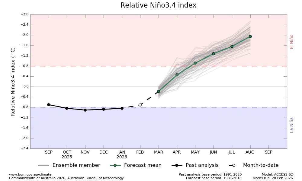
https://www.bom.gov.au/climate/enso/?ni ... iod=weekly
https://www.bom.gov.au/climate/ocean/ou ... abs=Graphs
0 likes
Visit the Caribbean-Central America Weather Thread where you can find at first post web cams,radars
and observations from Caribbean basin members Click Here
and observations from Caribbean basin members Click Here
-
jconsor
- Professional-Met

- Posts: 578
- Joined: Mon Jun 30, 2008 9:31 pm
- Location: Jerusalem, Israel
- Contact:
Re: 2026 ENSO Updates
Pretty deceiving in my view because this chart averages 15S-15N latitude. Vast majority of the strong westerly anomalies are from about 7.5 to 15N from second week of Mar heading into mid-Mar, with easterly anomalies in the central Pacific from near the equator to 15S.
Given the MJO progression EPS weeklies are showing in late Mar (8 to 1 to 2), would expect the westerly anomalies that are near/west of the dateline to progress into the Eastern and central Pacific, but be forecast outside the tropics than during the second week of Mar.
Given the MJO progression EPS weeklies are showing in late Mar (8 to 1 to 2), would expect the westerly anomalies that are near/west of the dateline to progress into the Eastern and central Pacific, but be forecast outside the tropics than during the second week of Mar.
0 likes
-
mixedDanilo.E
- Tropical Storm

- Posts: 103
- Joined: Sun Nov 21, 2021 8:00 am
- Location: NY
Re: 2026 ENSO Updates
jconsor wrote:Pretty deceiving in my view because this chart averages 15S-15N latitude. Vast majority of the strong westerly anomalies are from about 7.5 to 15N from second week of Mar heading into mid-Mar, with easterly anomalies in the central Pacific from near the equator to 15S.
Given the MJO progression EPS weeklies are showing in late Mar (8 to 1 to 2), would expect the westerly anomalies that are near/west of the dateline to progress into the Eastern and central Pacific, but be forecast outside the tropics than during the second week of Mar.
Yep this is a look at the EPS anomalies at 360 hours out. Strong westerlies but north of the EQ.

0 likes
-
cycloneye
- Admin
- Posts: 149260
- Age: 69
- Joined: Thu Oct 10, 2002 10:54 am
- Location: San Juan, Puerto Rico
Re: 2026 ENSO Updates
RONI for DJF is down to -0.9C.

https://www.cpc.ncep.noaa.gov/products/ ... atest-data
PDO for Febuary is down to -1.01.
https://www.ncei.noaa.gov/pub/data/cmb/ ... v5.pdo.dat
https://www.cpc.ncep.noaa.gov/products/ ... atest-data
PDO for Febuary is down to -1.01.
https://www.ncei.noaa.gov/pub/data/cmb/ ... v5.pdo.dat
1 likes
Visit the Caribbean-Central America Weather Thread where you can find at first post web cams,radars
and observations from Caribbean basin members Click Here
and observations from Caribbean basin members Click Here
-
cycloneye
- Admin
- Posts: 149260
- Age: 69
- Joined: Thu Oct 10, 2002 10:54 am
- Location: San Juan, Puerto Rico
Re: 2026 ENSO Updates
0 likes
Visit the Caribbean-Central America Weather Thread where you can find at first post web cams,radars
and observations from Caribbean basin members Click Here
and observations from Caribbean basin members Click Here
-
DorkyMcDorkface

- Category 4

- Posts: 984
- Age: 28
- Joined: Mon Sep 30, 2019 1:32 pm
- Location: Mid-Atlantic
Re: 2026 ENSO Updates
cycloneye wrote:RONI for DJF is down to -0.9C.
https://i.imgur.com/LRSQKqb.jpeg
https://www.cpc.ncep.noaa.gov/products/ ... atest-data
PDO for Febuary is down to -1.01.
https://www.ncei.noaa.gov/pub/data/cmb/ ... v5.pdo.dat
As long as the warm plume extending from Japan to S of the Aleutians remains, the index will have a hard time rising, despite the beginnings of +PMM arising. If anything, said waters have actually gotten warmer since last month. Is it just me or is the index more heavily dependent on that region than the horseshoe off the Pacific NA coast?

1 likes
Please note the thougths expressed by this account are solely those of the user and are from a hobbyist perspective. For more comprehensive analysis, consult an actual professional meteorologist or meteorology agency.
Floyd 1999 | Isabel 2003 | Hanna 2008 | Irene 2011 | Sandy 2012 | Isaias 2020
-
Kingarabian

- S2K Supporter

- Posts: 16345
- Joined: Sat Aug 08, 2009 3:06 am
- Location: Honolulu, Hawaii
Re: 2026 ENSO Updates
DorkyMcDorkface wrote:cycloneye wrote:RONI for DJF is down to -0.9C.
https://i.imgur.com/LRSQKqb.jpeg
https://www.cpc.ncep.noaa.gov/products/ ... atest-data
PDO for Febuary is down to -1.01.
https://www.ncei.noaa.gov/pub/data/cmb/ ... v5.pdo.dat
As long as the warm plume extending from Japan to S of the Aleutians remains, the index will have a hard time rising, despite the beginnings of +PMM arising. If anything, said waters have actually gotten warmer since last month. Is it just me or is the index more heavily dependent on that region than the horseshoe off the Pacific NA coast?
https://i.imgur.com/VbOiOF2.png
Well that region is half of the calculation and it's much more positive than the horseshoe off of the WCONUS. In prior decades we didn't see this issue where the waters east of Japan remain stubbornly warm.
1 likes
RIP Kobe Bryant
-
Kingarabian
- S2K Supporter
- Posts: 16345
- Joined: Sat Aug 08, 2009 3:06 am
- Location: Honolulu, Hawaii
Re: 2026 ENSO Updates
Kingarabian wrote:DorkyMcDorkface wrote:cycloneye wrote:RONI for DJF is down to -0.9C.
https://i.imgur.com/LRSQKqb.jpeg
https://www.cpc.ncep.noaa.gov/products/ ... atest-data
PDO for Febuary is down to -1.01.
https://www.ncei.noaa.gov/pub/data/cmb/ ... v5.pdo.dat
As long as the warm plume extending from Japan to S of the Aleutians remains, the index will have a hard time rising, despite the beginnings of +PMM arising. If anything, said waters have actually gotten warmer since last month. Is it just me or is the index more heavily dependent on that region than the horseshoe off the Pacific NA coast?
https://i.imgur.com/VbOiOF2.png
Well that region is half of the calculation and it's much more positive than the horseshoe off of the WCONUS. In prior decades we didn't see this issue where the waters east of Japan remain stubbornly warm.
I wonder if it's correlated to the SOI as the SOI has also been disconnected in terms of ENSO phase, similar to the PDO when it's not La Nina.
2 likes
RIP Kobe Bryant
-
cycloneye
- Admin
- Posts: 149260
- Age: 69
- Joined: Thu Oct 10, 2002 10:54 am
- Location: San Juan, Puerto Rico
Re: 2026 ENSO Updates
The next CPC important update will be on march 12th when they will have a complete analysis of how things are in ENSO and the probabilities of El Niño how will they be. Stay tuned for that but in the meantime, there will be models releasing their march runs from today like ECMWF and NMME on the 8th.
1 likes
Visit the Caribbean-Central America Weather Thread where you can find at first post web cams,radars
and observations from Caribbean basin members Click Here
and observations from Caribbean basin members Click Here
-
cycloneye
- Admin
- Posts: 149260
- Age: 69
- Joined: Thu Oct 10, 2002 10:54 am
- Location: San Juan, Puerto Rico
Re: 2026 ENSO Updates
Boom from ECMWF.

1 likes
Visit the Caribbean-Central America Weather Thread where you can find at first post web cams,radars
and observations from Caribbean basin members Click Here
and observations from Caribbean basin members Click Here


Re: 2026 ENSO Updates
DorkyMcDorkface wrote:cycloneye wrote:RONI for DJF is down to -0.9C.
https://i.imgur.com/LRSQKqb.jpeg
https://www.cpc.ncep.noaa.gov/products/ ... atest-data
PDO for Febuary is down to -1.01.
https://www.ncei.noaa.gov/pub/data/cmb/ ... v5.pdo.dat
As long as the warm plume extending from Japan to S of the Aleutians remains, the index will have a hard time rising, despite the beginnings of +PMM arising. If anything, said waters have actually gotten warmer since last month. Is it just me or is the index more heavily dependent on that region than the horseshoe off the Pacific NA coast?
https://i.imgur.com/VbOiOF2.png
We had a discussion a few page back how the PDO EOF has shifted more towards EOF2. NPAC SSTs are warming rapidly and the gradient is shifting much further north thus the persistent warmth east of Japan. Past historical references isn't helping much using the old method. How the PDO is effecting other regions is ever so changing, as is with other warming oceans. Much like ONI/RONI needed the adjustment so will the PDO.
4 likes
The above post and any post by Ntxw is NOT an official forecast and should not be used as such. It is just the opinion of the poster and may or may not be backed by sound meteorological data. It is NOT endorsed by any professional institution including Storm2k. For official information, please refer to NWS products.
Help support Storm2K!
-
Yellow Evan

- Professional-Met
- Posts: 16231
- Age: 27
- Joined: Fri Jul 15, 2011 12:48 pm
- Location: Henderson, Nevada/Honolulu, HI
- Contact:
Re: 2026 ENSO Updates
Post-February 2026 analog list
1957
1963
1982
1986
1997
2002
2014
Based primarily on February sea surface temperature configurations (specifically looking for years with +PMM, low amplitude PDO, and years that exited -ENSO but are also started to develop a costero and/or +SPMM), late winter/early spring trade wind pattern (both at and above the equator) and the sub surface. Both the February and September composite are a little too +PDO happy for my tastes but otherwise seem reasonable. A few years like 1968, 2018 and 2023 barely missed the cut and could merit inclusion depending on how the PMM or PDO behave next month.
3 likes
-
Kingarabian
- S2K Supporter
- Posts: 16345
- Joined: Sat Aug 08, 2009 3:06 am
- Location: Honolulu, Hawaii
Re: 2026 ENSO Updates
Yellow Evan wrote:Post-February 2026 analog list
1957
1963
1982
1986
1997
2002
2014
Based primarily on February sea surface temperature configurations (specifically looking for years with +PMM, low amplitude PDO, and years that exited -ENSO but are also started to develop a costero and/or +SPMM), late winter/early spring trade wind pattern (both at and above the equator) and the sub surface. Both the February and September composite are a little too +PDO happy for my tastes but otherwise seem reasonable. A few years like 1968, 2018 and 2023 barely missed the cut and could merit inclusion depending on how the PMM or PDO behave next month.
https://i.imgur.com/GwsQeze.jpeg
https://i.imgur.com/V8mfczv.jpeg
2014 is probably the most feasible option IMO.
0 likes
RIP Kobe Bryant
-
mixedDanilo.E
- Tropical Storm
- Posts: 103
- Joined: Sun Nov 21, 2021 8:00 am
- Location: NY
Re: 2026 ENSO Updates
Yellow Evan wrote:Post-February 2026 analog list
1957
1963
1982
1986
1997
2002
2014
Based primarily on February sea surface temperature configurations (specifically looking for years with +PMM, low amplitude PDO, and years that exited -ENSO but are also started to develop a costero and/or +SPMM), late winter/early spring trade wind pattern (both at and above the equator) and the sub surface. Both the February and September composite are a little too +PDO happy for my tastes but otherwise seem reasonable. A few years like 1968, 2018 and 2023 barely missed the cut and could merit inclusion depending on how the PMM or PDO behave next month.
https://i.imgur.com/GwsQeze.jpeg
https://i.imgur.com/V8mfczv.jpeg
I can't get myself to believe that the Atlantic will be that cold as it shows on the anomaly maps. It just seems impossible in the era that we are in, and especially if that doesn't happen, I wonder how that would impact the Atlantic's ability this year.
0 likes
-
Yellow Evan
- Professional-Met
- Posts: 16231
- Age: 27
- Joined: Fri Jul 15, 2011 12:48 pm
- Location: Henderson, Nevada/Honolulu, HI
- Contact:
Re: 2026 ENSO Updates
mixedDanilo.E wrote:Yellow Evan wrote:Post-February 2026 analog list
1957
1963
1982
1986
1997
2002
2014
Based primarily on February sea surface temperature configurations (specifically looking for years with +PMM, low amplitude PDO, and years that exited -ENSO but are also started to develop a costero and/or +SPMM), late winter/early spring trade wind pattern (both at and above the equator) and the sub surface. Both the February and September composite are a little too +PDO happy for my tastes but otherwise seem reasonable. A few years like 1968, 2018 and 2023 barely missed the cut and could merit inclusion depending on how the PMM or PDO behave next month.
https://i.imgur.com/GwsQeze.jpeg
https://i.imgur.com/V8mfczv.jpeg
I can't get myself to believe that the Atlantic will be that cold as it shows on the anomaly maps. It just seems impossible in the era that we are in, and especially if that doesn't happen, I wonder how that would impact the Atlantic's ability this year.
1982/1986 is probably skewing the MDR down a bit.
1 likes
-
cycloneye
- Admin
- Posts: 149260
- Age: 69
- Joined: Thu Oct 10, 2002 10:54 am
- Location: San Juan, Puerto Rico
Re: 2026 ENSO Updates
1 likes
Visit the Caribbean-Central America Weather Thread where you can find at first post web cams,radars
and observations from Caribbean basin members Click Here
and observations from Caribbean basin members Click Here
-
cycloneye
- Admin
- Posts: 149260
- Age: 69
- Joined: Thu Oct 10, 2002 10:54 am
- Location: San Juan, Puerto Rico
Re: 2026 ENSO Updates
Good point from Andy.
@AndyHazelton
This is a key point. At this point, it appears we will have a classic Wavenumber 1 (subsidence over the Atlantic and Africa, rising over the Pacific) El Niño. This means that shear and dry air across the Atlantic will likely be more like 1997, 2009, or 2015 than 2023, which was a highly unusual year with an extremely warm Atlantic that seems unlikely to repeat.
https://x.com/AndyHazelton/status/2029739425005985918
0 likes
Visit the Caribbean-Central America Weather Thread where you can find at first post web cams,radars
and observations from Caribbean basin members Click Here
and observations from Caribbean basin members Click Here
-
cycloneye
- Admin
- Posts: 149260
- Age: 69
- Joined: Thu Oct 10, 2002 10:54 am
- Location: San Juan, Puerto Rico
Re: 2026 ENSO Updates
https://x.com/BenNollWeather/status/2029901123948323276
https://x.com/BenNollWeather/status/2029901128612336065
https://x.com/BenNollWeather/status/2029901134794772831
https://x.com/BenNollWeather/status/2029901128612336065
https://x.com/BenNollWeather/status/2029901134794772831
1 likes
Visit the Caribbean-Central America Weather Thread where you can find at first post web cams,radars
and observations from Caribbean basin members Click Here
and observations from Caribbean basin members Click Here
-
cycloneye
- Admin
- Posts: 149260
- Age: 69
- Joined: Thu Oct 10, 2002 10:54 am
- Location: San Juan, Puerto Rico
Re: 2026 ENSO Updates
Here is a great thread from Eric Webb about the IOD and it's effects on ENSO.
https://x.com/webberweather/status/2030005880394240404
https://x.com/webberweather/status/2030007138656079922
https://x.com/webberweather/status/2030007987625202014
https://x.com/webberweather/status/2030008637368979874
https://x.com/webberweather/status/2030009534153118165
https://x.com/webberweather/status/2030011129548919107
0 likes
Visit the Caribbean-Central America Weather Thread where you can find at first post web cams,radars
and observations from Caribbean basin members Click Here
and observations from Caribbean basin members Click Here
Who is online
Users browsing this forum: No registered users and 88 guests