Texas Spring 2026

U.S. & Caribbean Weather Discussions and Severe Weather Events

Moderator: S2k Moderators

Forum rules

The posts in this forum are NOT official forecast and should not be used as such. They are just the opinion of the poster and may or may not be backed by sound meteorological data. They are NOT endorsed by any professional institution or STORM2K.

Help Support Storm2K
Message
Author
HockeyTx82
S2K Supporter
S2K Supporter
Posts: 2780
Joined: Tue Oct 27, 2009 11:17 am
Location: Ponder, TX

Re: Texas Spring 2026

#41 Postby HockeyTx82 » Tue Mar 03, 2026 6:43 am

0 likes   
Don't hold me accountable for anything I post on this forum. Leave the real forecasting up to the professionals.

Location: Ponder, TX (all observation posts are this location unless otherwise noted)

User avatar
Iceresistance
Category 5
Category 5
Posts: 9577
Age: 22
Joined: Sat Oct 10, 2020 9:45 am
Location: Tecumseh, OK/Norman, OK

Re: Texas Spring 2026

#42 Postby Iceresistance » Tue Mar 03, 2026 9:38 am

Ok, things are getting serious now :eek:

Image
https://s13.gifyu.com/images/bvyvQ.png

...Friday/Day 4 and Saturday/Day 5...
A strong upper-level system is forecast to eject northeastward into
the central High Plains on Friday, as an associated 60 to 80 knot
mid-level jet translates northeastward ahead of the trough. At the
surface, a moist and unstable airmass will likely be in place from
central and east Texas northward into the lower Missouri Valley.
Warming surface temperatures and increasing low-level convergence
will support scattered convective initiation to the west of the
moist axis. Storms are expected to grow upscale in the mid to late
afternoon, moving eastward toward an axis of strong low-level flow.
Moderate instability, strong deep-layer shear and steep lapse rates
will be favorable for supercells. Supercells should be capable of
producing tornadoes, large hail and severe wind gusts. The greatest
potential is forecast from near the Red River in north Texas
north-northeastward across eastern Oklahoma into eastern Kansas and
northwestern Missouri, where a 30 percent contour has been added. A
severe threat is also forecast northeastward into parts of the mid
to upper Mississippi Valley, where strong deep-layer shear and
sufficient low-level moisture will be in place for a severe threat.
0 likes   
Bill 2015 & Beta 2020

Winter 2020-2021 :cold:

All observations are in Tecumseh, OK unless otherwise noted.

Winter posts are focused mainly for Oklahoma & Texas.

Take any of my forecasts with a grain of salt, refer to the NWS, SPC, and NHC for official information

Never say Never with weather! Because ANYTHING is possible!

Lagreeneyes03
Category 2
Category 2
Posts: 609
Joined: Mon Dec 09, 2013 10:53 am
Location: Luxurious Lake Grapevine

Re: Texas Spring 2026

#43 Postby Lagreeneyes03 » Tue Mar 03, 2026 12:14 pm

I see the 30 percent bubble moved out of North Texas and to the Red River and points north.
0 likes   
I'm a Princess, not a forecaster.

User avatar
txtwister78
Category 5
Category 5
Posts: 2157
Joined: Wed Jan 30, 2019 12:56 pm
Location: San Antonio

Re: Texas Spring 2026

#44 Postby txtwister78 » Tue Mar 03, 2026 1:40 pm

Stratton23 wrote:I should clarify rain totals have gone down in SE texas, ill believe a wet pattern when i actually see rain falling from the sky lol


No I get the skepticism regarding what some might believe. It's been a minute for a good soaking pattern down here. That's sort of like my feeling though when I see talk of big cold coming in mid March down in Texas.

Here though I still think the signal is actually pretty good and it's Spring after all so at least we've got that going for us. Hoping you cash in also.
0 likes   

Stratton23
Category 5
Category 5
Posts: 3514
Joined: Fri Jul 21, 2023 10:59 pm
Location: Katy, Tx

Re: Texas Spring 2026

#45 Postby Stratton23 » Tue Mar 03, 2026 1:43 pm

txtwister78 yeah i just hope we get rain regardless of totals, but honestly it might be a bad thing to get locked into a wet pattern right now before summer, last couple times thats happened, summer has ended up being a torch and very dry, its a weird cycle that needs to be broken
0 likes   

Stratton23
Category 5
Category 5
Posts: 3514
Joined: Fri Jul 21, 2023 10:59 pm
Location: Katy, Tx

Re: Texas Spring 2026

#46 Postby Stratton23 » Tue Mar 03, 2026 3:10 pm

We all need the rain badly, but the trend is not anyones friend, WPC has continuously shifted NE with the heaviest totals now focused in NE texas, hill country to houston now look like an inch or less over the next 7-10 days
0 likes   

User avatar
SnowyOwl31
Tropical Wave
Tropical Wave
Posts: 5
Age: 32
Joined: Mon Feb 02, 2026 4:08 pm
Location: Texas City, TX

Re: Texas Spring 2026

#47 Postby SnowyOwl31 » Tue Mar 03, 2026 4:09 pm

Stratton23 wrote:We all need the rain badly, but the trend is not anyones friend, WPC has continuously shifted NE with the heaviest totals now focused in NE texas, hill country to houston now look like an inch or less over the next 7-10 days


Wouldn't surprise me if that is the story for our area throughout spring...I'm of the belief that the only way we'll get significant rain for our area will be due to tropical activity in the Gulf, just seems like we miss out any other way.
0 likes   

Brent
S2K Supporter
S2K Supporter
Posts: 38717
Age: 37
Joined: Sun May 16, 2004 10:30 pm
Location: Tulsa Oklahoma
Contact:

Re: Texas Spring 2026

#48 Postby Brent » Tue Mar 03, 2026 7:48 pm

Just to add to that but even up here in Oklahoma I'm seeing multiple people saying don't believe the rain maps :spam:

Well see obviously but like I've been skeptical all along given how much people have hyped it up

And don't even get me started on the severe weather hype. Friday especially I get it but you can't even tell this far out. If the front goes through faster we will clear out and its east of us again like always
0 likes   
#neversummer

Haddox12
Tropical Low
Tropical Low
Posts: 11
Joined: Thu Aug 24, 2017 11:02 am

Re: Texas Spring 2026

#49 Postby Haddox12 » Wed Mar 04, 2026 7:45 am

Why is it so sleepy in here? We have our first enhanced risk of the season today and no one is sharing models or talking about the cap or anything!
0 likes   

User avatar
Iceresistance
Category 5
Category 5
Posts: 9577
Age: 22
Joined: Sat Oct 10, 2020 9:45 am
Location: Tecumseh, OK/Norman, OK

Re: Texas Spring 2026

#50 Postby Iceresistance » Wed Mar 04, 2026 9:28 am

That's a big slight on D7 :eek:

Image
https://s13.gifyu.com/images/bvJvS.png

...Monday/Day 6 to Wednesday/Day 8...
West-southwesterly mid-level flow is forecast to continue on Monday
across much of the central and eastern U.S. Low-level moisture
return is forecast to take place over the southern and central
Plains, where the models suggest moderate instability will be
possible by afternoon. As a low-level jet strengthens during the
afternoon and evening, isolated to scattered thunderstorms should
develop in areas that heat up sufficiently. A severe threat would be
possible. However, spatial uncertainty exists concerning where any
severe threat will be the greatest.

On Tuesday, model forecasts are in general agreement, moving an
upper-level trough northeastward into the southern High Plains. An
associated mid-level jet is forecast to eject northeastward ahead of
the system. Model forecasts suggest that the airmass ahead of the
trough will become moderately unstable by Tuesday afternoon. This
combined with strong large-scale ascent should support scattered
severe storms in the afternoon and evening. The favored severe
threat area is expected from parts of the southern and central
Plains eastward into the Ozarks.
1 likes   
Bill 2015 & Beta 2020

Winter 2020-2021 :cold:

All observations are in Tecumseh, OK unless otherwise noted.

Winter posts are focused mainly for Oklahoma & Texas.

Take any of my forecasts with a grain of salt, refer to the NWS, SPC, and NHC for official information

Never say Never with weather! Because ANYTHING is possible!

Brent
S2K Supporter
S2K Supporter
Posts: 38717
Age: 37
Joined: Sun May 16, 2004 10:30 pm
Location: Tulsa Oklahoma
Contact:

Re: Texas Spring 2026

#51 Postby Brent » Wed Mar 04, 2026 9:31 am

Well it rained for about a half hour. Maybe enough to settle the dust

Again it cleared out really quickly... That's what I keep wondering about with Friday and all these severe days. It's been the pattern for months
0 likes   
#neversummer

TomballEd
Category 5
Category 5
Posts: 1259
Age: 62
Joined: Wed Aug 16, 2023 4:52 pm
Location: Spring/Klein area, not Tomball

Re: Texas Spring 2026

#52 Postby TomballEd » Wed Mar 04, 2026 11:48 am

GEFS maybe trending towards Euro. Looking at 6Z and 0Z ensemble runs. 2 inches of rain in the next 6 days here would be super appreciated.
0 likes   

User avatar
wxman22
Category 5
Category 5
Posts: 1876
Joined: Mon Jan 30, 2006 12:39 am
Location: Wichita Falls, TX
Contact:

Re: Texas Spring 2026

#53 Postby wxman22 » Wed Mar 04, 2026 11:51 am

The HRRR shows supercells developing in parts of North Texas this evening/ tonight.

Image
Image
0 likes   

HockeyTx82
S2K Supporter
S2K Supporter
Posts: 2780
Joined: Tue Oct 27, 2009 11:17 am
Location: Ponder, TX

Re: Texas Spring 2026

#54 Postby HockeyTx82 » Wed Mar 04, 2026 2:48 pm

Starting to see some returns on the radar.
0 likes   
Don't hold me accountable for anything I post on this forum. Leave the real forecasting up to the professionals.

Location: Ponder, TX (all observation posts are this location unless otherwise noted)

User avatar
wxman22
Category 5
Category 5
Posts: 1876
Joined: Mon Jan 30, 2006 12:39 am
Location: Wichita Falls, TX
Contact:

Re: Texas Spring 2026

#55 Postby wxman22 » Wed Mar 04, 2026 5:11 pm

Image

Mesoscale Discussion 0133
NWS Storm Prediction Center Norman OK
0301 PM CST Wed Mar 04 2026

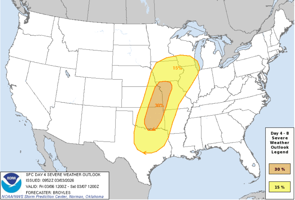
Areas affected...Parts of north/northeast Texas into southeastern
Oklahoma

Concerning...Severe potential...Watch possible

Valid 042101Z - 050000Z

Probability of Watch Issuance...40 percent

SUMMARY...A few severe storms are possible this afternoon into the
evening, with the primary concerns being damaging gusts and severe
hail. A watch may eventually be needed.

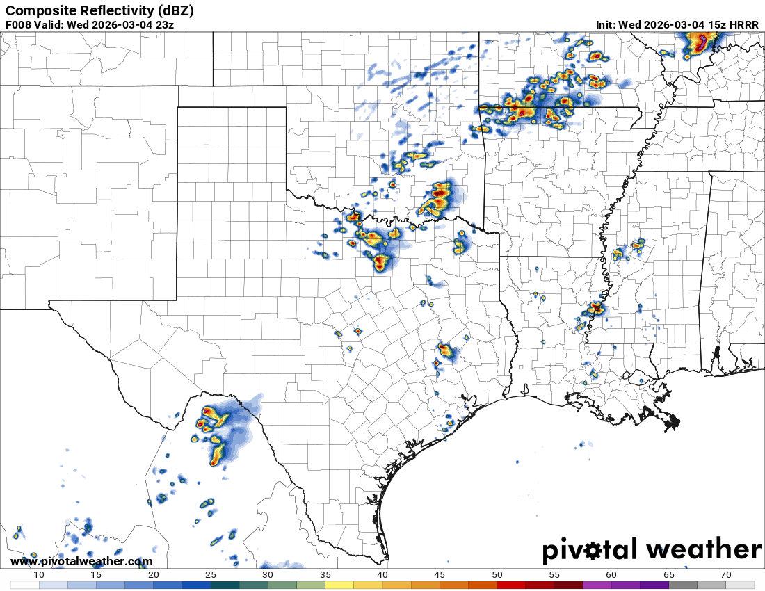
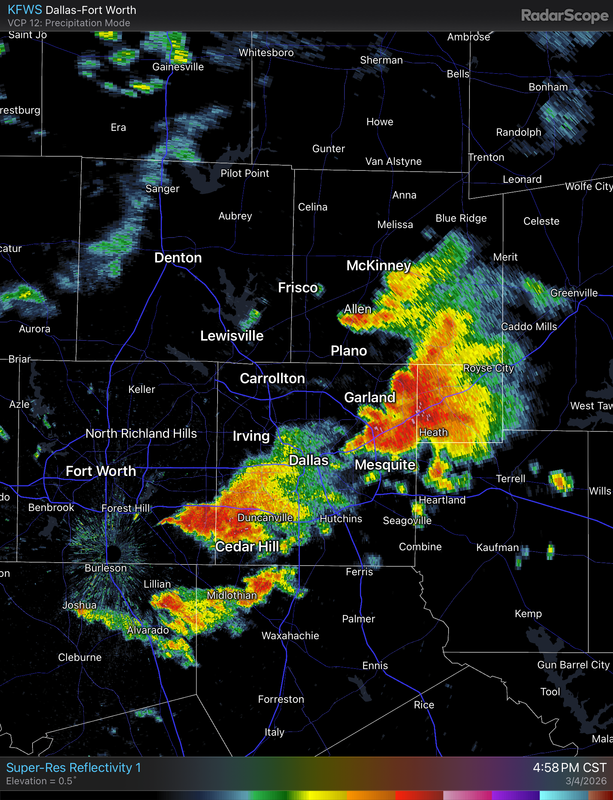
DISCUSSION...The latest visible satellite imagery shows continued
diurnal heating/destabilization of a relatively moist air mass
(middle/upper 60s dewpoints) extending from parts of north/northeast
TX toward the Red River. Despite weak large-scale forcing for
ascent, continued erosion of inhibition at the base of the EML (see
latest DAL ACARS soundings) is promoting isolated convective
initiation within zones of differential heating and low-level
confluence. Current thinking is that this trend will continue
through the afternoon, with mainly isolated storm coverage. While
modest deep-layer shear (25-30-kt midlevel flow per FWS VWP) and the
weak large-scale ascent may limit storm organization in the
near-term, the destabilizing boundary layer and steep midlevel lapse
rates may still promote locally damaging gusts and sporadic severe
hail on an isolated basis this afternoon.

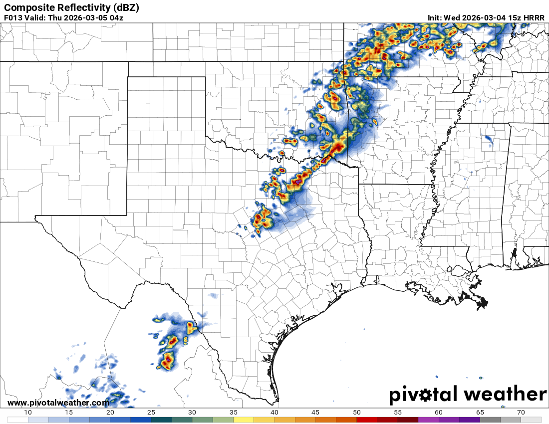
With time, a strengthening southerly low-level jet should favor
additional storm development and organization later this afternoon
into the evening, when the risk of damaging winds and severe hail
should increase. A watch may eventually be needed for parts of the
area, though timing is uncertain.

..Weinman/Guyer.. 03/04/2026

...Please see www.spc.noaa.gov for graphic product...

ATTN...WFO...SHV...TSA...FWD...OUN...

LAT...LON 32359798 33259762 33959714 34289680 34469634 34479578
34309540 33969519 33369515 32439545 31559595 31239658
31239726 31469771 31829799 32359798

MOST PROBABLE PEAK TORNADO INTENSITY...UP TO 95 MPH
MOST PROBABLE PEAK WIND GUST...55-70 MPH
MOST PROBABLE PEAK HAIL SIZE...1.00-1.75 IN
0 likes   

Stratton23
Category 5
Category 5
Posts: 3514
Joined: Fri Jul 21, 2023 10:59 pm
Location: Katy, Tx

Re: Texas Spring 2026

#56 Postby Stratton23 » Wed Mar 04, 2026 5:37 pm

Eric Webb posted on twitter that our current SSWE could have an impact on this summer, that doesnt sound like a good thing at all, but if anyone knows how that would effect summer, i would be interested to know
0 likes   

User avatar
wxman22
Category 5
Category 5
Posts: 1876
Joined: Mon Jan 30, 2006 12:39 am
Location: Wichita Falls, TX
Contact:

Re: Texas Spring 2026

#57 Postby wxman22 » Wed Mar 04, 2026 6:01 pm

Supercells have developed over DFW. A watch has also been issued.

Image

Image
1 likes   

User avatar
Iceresistance
Category 5
Category 5
Posts: 9577
Age: 22
Joined: Sat Oct 10, 2020 9:45 am
Location: Tecumseh, OK/Norman, OK

Re: Texas Spring 2026

#58 Postby Iceresistance » Wed Mar 04, 2026 6:14 pm

wxman22 wrote:Supercells have developed over DFW. A watch has also been issued.

https://i.postimg.cc/x8kKmD0L/IMG-0682.png

https://www.spc.noaa.gov/products/watch/ww0012_overview_big_wou.gif

The storm near Cedar Hill is now severe warned for Quarter Sized Hail and 60 mph winds
1 likes   
Bill 2015 & Beta 2020

Winter 2020-2021 :cold:

All observations are in Tecumseh, OK unless otherwise noted.

Winter posts are focused mainly for Oklahoma & Texas.

Take any of my forecasts with a grain of salt, refer to the NWS, SPC, and NHC for official information

Never say Never with weather! Because ANYTHING is possible!

gpsnowman
S2K Supporter
S2K Supporter
Posts: 3366
Joined: Fri Jan 07, 2011 10:35 am
Location: Grand Prairie Tx

Re: Texas Spring 2026

#59 Postby gpsnowman » Wed Mar 04, 2026 6:17 pm

Iceresistance wrote:
wxman22 wrote:Supercells have developed over DFW. A watch has also been issued.

https://i.postimg.cc/x8kKmD0L/IMG-0682.png

https://www.spc.noaa.gov/products/watch/ww0012_overview_big_wou.gif

The storm near Cedar Hill is now severe warned for Quarter Sized Hail and 60 mph winds

Very close to there. Huge rains here in Grand Prairie. Large drops and heavy. Starting to hail pea size.
1 likes   

gpsnowman
S2K Supporter
S2K Supporter
Posts: 3366
Joined: Fri Jan 07, 2011 10:35 am
Location: Grand Prairie Tx

Re: Texas Spring 2026

#60 Postby gpsnowman » Wed Mar 04, 2026 6:18 pm

Hail getting heavier. No bueno.
0 likes   


Return to “USA & Caribbean Weather”

Who is online

Users browsing this forum: No registered users and 34 guests