Texas Spring 2026
Moderator: S2k Moderators
Forum rules

The posts in this forum are NOT official forecast and should not be used as such. They are just the opinion of the poster and may or may not be backed by sound meteorological data. They are NOT endorsed by any professional institution or STORM2K.
-
rwfromkansas
- Category 5

- Posts: 3029
- Joined: Sat Aug 27, 2005 12:47 am
- Location: North Fort Worth
Re: Texas Spring 2026
I am still on the eastern edge of the elevated risk in Tarrant. I don't want massive hail after replacing the roof last year anyway, but I do enjoy severe storms, just not the worst of them.
0 likes

Re: Texas Spring 2026
Doesn’t feel like an enhanced risk type of day out. Guess we will see if clouds lift.
0 likes
-
TomballEd
- Category 5
- Posts: 1277
- Age: 62
- Joined: Wed Aug 16, 2023 4:52 pm
- Location: Spring/Klein area, not Tomball
Re: Texas Spring 2026
Gotwood wrote:Doesn’t feel like an enhanced risk type of day out. Guess we will see if clouds lift.
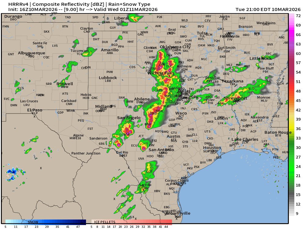
HRRR at 8 pm had about 1800 j/Kg MLCAPE and a 40 knot LLJ from from the S with a 65 knot SSW winds at 500 mb on 15Z run, enhanced risk seems possible. 16Z run coming in looks even better on simulated radar. 16Z run STP

0 likes


Re: Texas Spring 2026
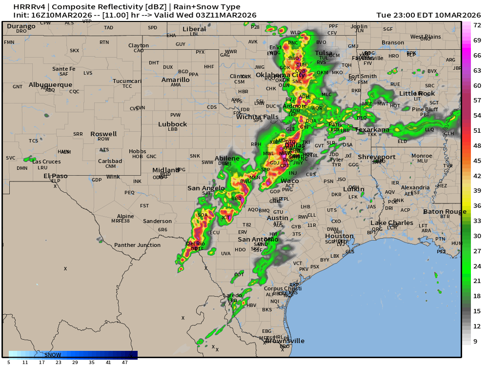
Here is a snippet of the risks from SPC. People these days see enhanced risk and assume the worst but categorically if decent coverage in severe thunderstorms (hail, wind etc) all qualify. In fact I would argue the risks are more lean towards the confidence of coverage. It doesn't automatically mean supercells and tornadoes. We have to read the discussion for the tornado etc level risks.

That said HRRR has a pretty widespread wall coverage/linear of storms, coverage quantifies. Maybe a few embedded strong/tor warned storms especially when they initiate before congealing.

That said HRRR has a pretty widespread wall coverage/linear of storms, coverage quantifies. Maybe a few embedded strong/tor warned storms especially when they initiate before congealing.
0 likes
The above post and any post by Ntxw is NOT an official forecast and should not be used as such. It is just the opinion of the poster and may or may not be backed by sound meteorological data. It is NOT endorsed by any professional institution including Storm2k. For official information, please refer to NWS products.
Help support Storm2K!
-
Fifty Rock
- Tropical Storm

- Posts: 153
- Joined: Mon Sep 11, 2023 10:08 am
- Location: Albany, Texas
Re: Texas Spring 2026
Gotwood wrote:Doesn’t feel like an enhanced risk type of day out. Guess we will see if clouds lift.
It's clear and 83* right now near Albany in West Texas only about 75 miles West of you.
0 likes
-
wxman22

- Category 5
- Posts: 1913
- Joined: Mon Jan 30, 2006 12:39 am
- Location: Wichita Falls, TX
- Contact:
Re: Texas Spring 2026
Fifty Rock wrote:Gotwood wrote:Doesn’t feel like an enhanced risk type of day out. Guess we will see if clouds lift.
It's clear and 83* right now near Albany in West Texas only about 75 miles West of you.
Yep it’s sunny here also in Wichita Falls.
0 likes
-
rwfromkansas
- Category 5
- Posts: 3029
- Joined: Sat Aug 27, 2005 12:47 am
- Location: North Fort Worth
Re: Texas Spring 2026
The clouds are slowly, slowly mixing east, but may still be over DFW for much of the day, but close enough to clearing to still pack a punch likely.
0 likes
-
txtwister78

- Category 5
- Posts: 2172
- Joined: Wed Jan 30, 2019 12:56 pm
- Location: San Antonio
-
rwfromkansas
- Category 5
- Posts: 3029
- Joined: Sat Aug 27, 2005 12:47 am
- Location: North Fort Worth
-
txtwister78
- Category 5
- Posts: 2172
- Joined: Wed Jan 30, 2019 12:56 pm
- Location: San Antonio
Re: Texas Spring 2026
Tornado Watch likely later this afternoon for portions of West Central TX down into the Hill Country/Southern Edwards Plateau region per SPC
1 likes
-
Fifty Rock
- Tropical Storm
- Posts: 153
- Joined: Mon Sep 11, 2023 10:08 am
- Location: Albany, Texas
Re: Texas Spring 2026
Not sure why they would put that out there. Seems like a mess up on someone's part.
0 likes
-
Fifty Rock
- Tropical Storm
- Posts: 153
- Joined: Mon Sep 11, 2023 10:08 am
- Location: Albany, Texas
Re: Texas Spring 2026
Not sure why they would put that out there. Seems like a mess up on someone's part.
0 likes
Re: Texas Spring 2026
txtwister78 wrote:Tornado Watch likely later this afternoon for portions of West Central TX down into the Hill Country/Southern Edwards Plateau region per SPC
This was always the area to watch.
0 likes
-
rwfromkansas
- Category 5
- Posts: 3029
- Joined: Sat Aug 27, 2005 12:47 am
- Location: North Fort Worth
Re: Texas Spring 2026
I don't think the cap really changes the calculus for later, just not many initial discrete storms, right?
1 likes
-
CaptinCrunch

- S2K Supporter

- Posts: 8779
- Age: 58
- Joined: Mon Nov 03, 2003 4:33 pm
- Location: Kennedale, TX (Tarrant Co.)
Re: Texas Spring 2026
Meteorological winter -- December to February -- was unseasonably warm across much of the contiguous U.S., ranking as the second-warmest winter on record since 1895, behind the 2023-24 season, according to a new report from the National Oceanic and Atmospheric Administration (NOAA).
While the Northeast faced persistent blasts of bitter cold and snow, exceptional winter warmth in the West nearly pushed the nation to a new all-time high for the season.
Nine states finished off with their warmest winter on record: Arizona, Colorado, New Mexico, Nevada, Texas, Oklahoma, Oregon, Utah and Wyoming. Dozens of cities in the West and Plains saw a top 5 warmest winter with cities such as Albuquerque, Phoenix, Las Vegas, and Salt Lake City seeing their all-time warmest.
Dallas, Texas, recorded 16 days with high temperatures of at least 80°F, the highest seasonal total on record.
For much of the country, winter was not only exceptionally warm, but exceptionally dry, ranking as the driest winter in 45 years across the Lower 48. Much of the western United States entered the season already grappling with drought, and persistent warmth fueled the worst snow drought in decades across parts of the Rockies as more precipitation fell as rain instead of snow.
Widespread, persistent drier-than-average conditions also impacted parts of the Heartland and Southeast, bringing drought expansion and intensification during the winter months. Multiple states, including Arkansas, Missouri, Illinois and Nebraska, experienced one of their driest winters on record.
According to the latest U.S. Drought Monitor report released on March 5, more than half of the contiguous U.S. is experiencing drought conditions, an increase of about 10% from the beginning of February.
2025 was Earth's 3rd-warmest year as climate impacts intensify. Florida is enduring its worst drought in 25 years, according to the National Integrated Drought Information System, with a heightened risk of wildfires this spring as conditions worsen across the state. All of Florida is currently experiencing some level of drought, with more than 70% of the state facing an extreme drought level 3 of 4, U.S. Drought Monitor data shows.
1 likes
-
wxman22
- Category 5
- Posts: 1913
- Joined: Mon Jan 30, 2006 12:39 am
- Location: Wichita Falls, TX
- Contact:
Re: Texas Spring 2026
The latest HRRR run It’s been consistently showing some potent storms here fwiw.
0 likes
-
wxman22
- Category 5
- Posts: 1913
- Joined: Mon Jan 30, 2006 12:39 am
- Location: Wichita Falls, TX
- Contact:
Re: Texas Spring 2026
Here we go.
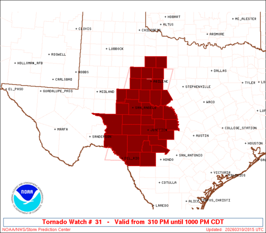
URGENT - IMMEDIATE BROADCAST REQUESTED
Tornado Watch Number 31
NWS Storm Prediction Center Norman OK
310 PM CDT Tue Mar 10 2026
The NWS Storm Prediction Center has issued a
* Tornado Watch for portions of
West-Central Texas
* Effective this Tuesday afternoon and evening from 310 PM until
1000 PM CDT.
* Primary threats include...
A few tornadoes likely with a couple intense tornadoes possible
Scattered large hail and isolated very large hail events to 4
inches in diameter likely
Scattered damaging winds likely with isolated significant gusts
to 80 mph possible
SUMMARY...Supercell thunderstorms will quickly develop this
afternoon and evening while posing a threat for very large to
possibly giant hail initially (up to 3-4 inches in diameter). The
threat for a few tornadoes will increase this evening with any
persistent supercells, and a strong tornado appears possible. An
increasing threat for severe/damaging winds up to 70-80 mph should
also occur as thunderstorms eventually grow upscale into one or more
bowing clusters.
0 likes
-
HockeyTx82
- S2K Supporter
- Posts: 2791
- Joined: Tue Oct 27, 2009 11:17 am
- Location: Ponder, TX
Re: Texas Spring 2026
It looks like DFW's back in the enhanced again......

0 likes
Don't hold me accountable for anything I post on this forum. Leave the real forecasting up to the professionals.
Location: Ponder, TX (all observation posts are this location unless otherwise noted)
Location: Ponder, TX (all observation posts are this location unless otherwise noted)
-
TomballEd
- Category 5
- Posts: 1277
- Age: 62
- Joined: Wed Aug 16, 2023 4:52 pm
- Location: Spring/Klein area, not Tomball
Re: Texas Spring 2026
HockeyTx82 wrote:It looks like DFW's back in the enhanced again......
FTW is, DAL is not.
0 likes
Return to “USA & Caribbean Weather”
Who is online
Users browsing this forum: No registered users and 76 guests