Texas Spring 2026
Moderator: S2k Moderators
Forum rules

The posts in this forum are NOT official forecast and should not be used as such. They are just the opinion of the poster and may or may not be backed by sound meteorological data. They are NOT endorsed by any professional institution or STORM2K.
-
Stratton23
- Category 5

- Posts: 3563
- Joined: Fri Jul 21, 2023 10:59 pm
- Location: Katy, Tx
Re: Texas Spring 2026
00z EURO has a foot + of rain in parts of the state over the next 10-15 days , insane
0 likes
Re: Texas Spring 2026
snownado wrote:Warmest March on record for DFW draws to a close, with an average of at least 67.4*F.
It was indeed a little drier than average, but nothing to write home about (2.92")...
67.6*F is the official number, 0.9*F above the previous record warmest March (1907)...
Interesting enough, March seems to be one month where a fair amount of the top 10 list predates 1950...
0 likes
-
wxman22

- Category 5
- Posts: 1943
- Joined: Mon Jan 30, 2006 12:39 am
- Location: Wichita Falls, TX
- Contact:
Re: Texas Spring 2026
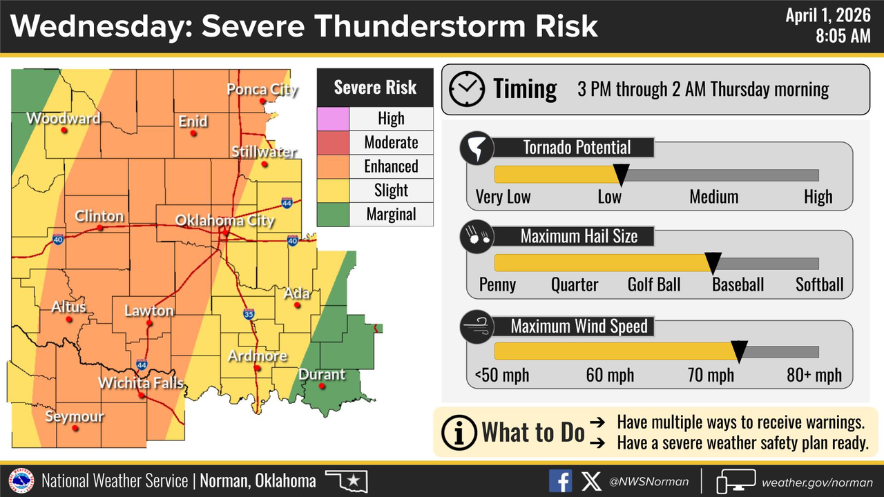
Day 1 Convective Outlook
NWS Storm Prediction Center Norman OK
0751 AM CDT Wed Apr 01 2026
Valid 011300Z - 021200Z
...THERE IS AN ENHANCED RISK OF SEVERE THUNDERSTORMS ACROSS
NORTHWEST TEXAS...WESTERN/CENTRAL OKLAHOMA...AND SOUTH-CENTRAL
KANSAS...
...THERE IS A SLIGHT RISK OF SEVERE THUNDERSTORMS PORTIONS OF THE
MIDDLE OHIO VALLEY AND MID-ATLANTIC...
...SUMMARY...
Severe thunderstorms with damaging wind gusts, large hail and a few
tornadoes are likely across the southern and central Plains this
afternoon and evening. Strong to severe storms are also possible
from parts of the Ohio Valley, central Appalachians and
Mid-Atlantic.
...Synopsis...
Early morning radar and satellite imagery shows a cluster of
thunderstorms moving through central MO, just to the north and east
of a surface low over far southwest MO. Surface analysis shows a
cold front extending from this low northeastward across the OH
Valley and Northeast to another low over NH. A stationary boundary
also extends southwestward from the southwest MO low across central
and southwest OK, and northwest TX to another low over the Permian
Basin. Thunderstorms are expected to focus on each of these
boundaries today, particularly from the middle OH Valley into the
Mid-Atlantic and over large portion of the central/southern Plains
and Mid MS Valley. Severe thunderstorms are possible across these
regions as well, with the highest severe thunderstorm coverage
expected from northwest TX through western OK into south-central KS.
...Central/Southern Plains...
Low-level moisture advection is anticipated across the southern
Plains today as the shortwave trough currently moving through the
southern Great Basin continues quickly eastward, reaching the
central Plains by early tomorrow. General expectation is for the
stationary boundary mentioned in the synopsis to push north as warm
front and for mid 60s dewpoints to cover much of OK by the late
afternoon. This increasing low-level moisture beneath steep lapse
rates (over 7 to 7.5 deg C per 12Z soundings and recent
mesoanalysis) will support moderate to strong buoyancy from
southwest TX into much of central and western OK. Height falls
attendant to the approaching shortwave will begin spreading over
this destabilizing airmass by the early afternoon, combining with
low-level convergence along the front and dryline to support
convective initiation between 21Z and 00Z.
Given the expectation that convective inhibition will be limited, if
present at all, widespread development is anticipated from western
OK into southwest TX. Kinematic profiles support supercells, but the
persistent ascent and extensive nature of the convective initiation
suggest that a discrete convective mode will be difficult to
maintain and a quick transition to a convective line appears
probable. As such, strong gusts appear to be the primary severe
risk. Even so, steep lapse rates should still support large hail,
even within the convective line. Very large hail (i.e. 2"+ in
diameter) is possible if a discrete mode can be maintained. A
discrete mode could also increase the tornado potential, but higher
probabilities (i.e. 10%) were not introduced given the likely storm
interactions and expected quick convective evolution into a line.
Some tornado risk will still be present within the line,
particularly during the 00-04Z period as low-level hodographs
lengthen amid a strengthening low-level jet.
0 likes


Re: Texas Spring 2026
Alaska had it's coldest DJF-March on record for Fairbanks and a number of other locations. It's been very cold over AK and the Yukon so that's the natural variability there in terms of patterns. Probably explains some of the reasons we had one of the warmest winters, and March. EPO has not been our friend for months.
2 likes
The above post and any post by Ntxw is NOT an official forecast and should not be used as such. It is just the opinion of the poster and may or may not be backed by sound meteorological data. It is NOT endorsed by any professional institution including Storm2k. For official information, please refer to NWS products.
Help support Storm2K!
-
wxman22
- Category 5
- Posts: 1943
- Joined: Mon Jan 30, 2006 12:39 am
- Location: Wichita Falls, TX
- Contact:
Re: Texas Spring 2026

Mesoscale Discussion 0319
NWS Storm Prediction Center Norman OK
0339 PM CDT Wed Apr 01 2026
Areas affected...Parts of northwest TX...western/central
OK...southern KS
Concerning...Severe potential...Tornado Watch likely
Valid 012039Z - 012215Z
Probability of Watch Issuance...95 percent
SUMMARY...Severe storm development is expected from late afternoon
into the evening. Tornado Watch issuance is likely in the next 1-2
hours.
DISCUSSION...Heating/destabilization is underway this afternoon
across much of TX/OK, along/south of a northward-moving warm front.
Steep lapse rates were noted within the 800-500 mb layer from the
18Z LMN sounding, though with weaker lapse rates noted above 500 mb
within an extensive cirrus plume. Temperatures in the low 80s F and
dewpoints in the low/mid 60s are supporting MLCAPE generally in the
1000-2000 J/kg range along/south of the warm front, and along/east
of a diffuse dryline extending from the southeast TX Panhandle into
southwest TX.
While deep-layer flow (as depicted by regional VWPs and objective
mesoanalyses) is currently rather modest, an increase in both
low-level and deep-layer shear is expected with time into the
evening, in response to an approaching mid/upper-level shortwave
trough. Increasing ascent and weakening MLCINH should eventually
result in storm development near the warm front and southward along
the dryline by late afternoon into the early evening, with
additional warm sector development possible as the low-level jet
continues to intensify.
Initial storm development is expected to evolve into a broken band
of supercells, with an attendant threat of large to very large hail,
localized severe gusts, and eventually a tornado threat as low-level
shear/SRH continues to increase. Guidance varies regarding the
duration of discrete supercell potential before upscale growth
occurs, but a conditional strong tornado threat could accompany any
persistent supercell into the evening. Tornado Watch issuance is
expected later this afternoon or early evening in response to these
threats.
..Dean/Hart.. 04/01/2026
0 likes

Return to “USA & Caribbean Weather”
Who is online
Users browsing this forum: Brent and 142 guests