PGSN 140210Z AUTO 03055G78KT 1/4SM +RA FG OVC012 26/25 A2876 RMK AO2 PK WND 02081/0159 PRESFR P0015 T02560250 TSNO $
Pressure is down to 974 hPa
Sustained wind is up to 55 knots gusting to 78 knots
WPAC: SINLAKU - Typhoon
Moderators: S2k Moderators, WesternPacificWeatherMods
Forum rules

The posts in this forum are NOT official forecast and should not be used as such. They are just the opinion of the poster and may or may not be backed by sound meteorological data. They are NOT endorsed by any professional institution or STORM2K.
-
mrbagyo

- Category 5

- Posts: 3997
- Age: 33
- Joined: Thu Apr 12, 2012 9:18 am
- Location: 14.13N 120.98E
- Contact:
Re: WPAC: SINLAKU - Typhoon
0 likes
The posts in this forum are NOT official forecast and should not be used as such. They are just the opinion of the poster and may or may not be backed by sound meteorological data. They are NOT endorsed by any professional institution or storm2k.org. For official information, please refer to RSMC, NHC and NWS products.

-
mrbagyo
- Category 5
- Posts: 3997
- Age: 33
- Joined: Thu Apr 12, 2012 9:18 am
- Location: 14.13N 120.98E
- Contact:
Re: WPAC: SINLAKU - Typhoon
Davis Vantage AWS on top of a hill in Saipan is rockin 100+ mph gust
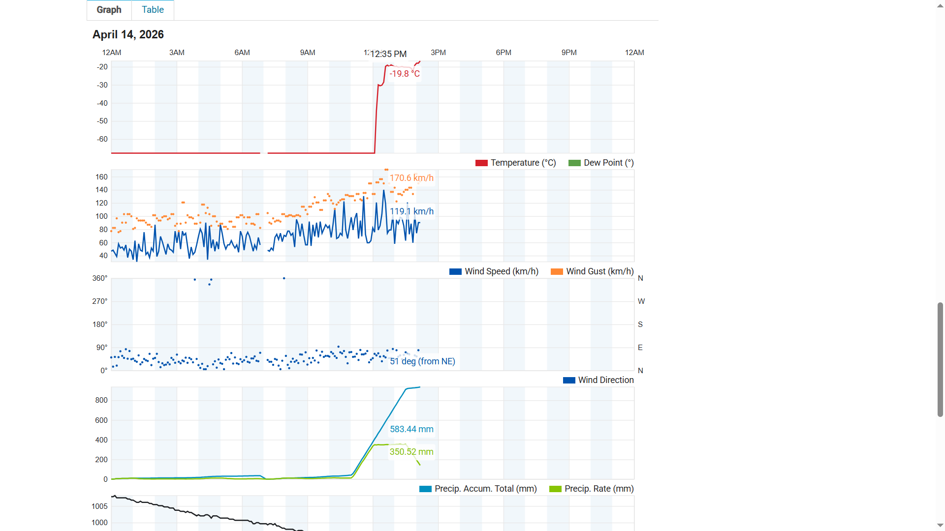
Ambient AWS near the airport is also registering 100 mph gust
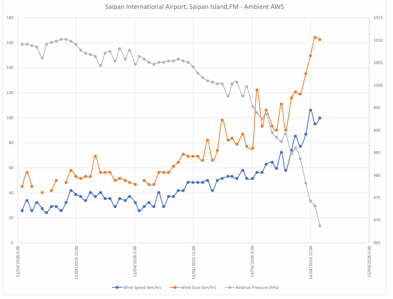
Ambient AWS near the airport is also registering 100 mph gust
0 likes
The posts in this forum are NOT official forecast and should not be used as such. They are just the opinion of the poster and may or may not be backed by sound meteorological data. They are NOT endorsed by any professional institution or storm2k.org. For official information, please refer to RSMC, NHC and NWS products.
-
mrbagyo
- Category 5
- Posts: 3997
- Age: 33
- Joined: Thu Apr 12, 2012 9:18 am
- Location: 14.13N 120.98E
- Contact:
Re: WPAC: SINLAKU - Typhoon
That anemometer is done
0 likes
The posts in this forum are NOT official forecast and should not be used as such. They are just the opinion of the poster and may or may not be backed by sound meteorological data. They are NOT endorsed by any professional institution or storm2k.org. For official information, please refer to RSMC, NHC and NWS products.
-
cycloneye

- Admin

- Posts: 149708
- Age: 69
- Joined: Thu Oct 10, 2002 10:54 am
- Location: San Juan, Puerto Rico
Re: WPAC: SINLAKU - Typhoon
0 likes
Visit the Caribbean-Central America Weather Thread where you can find at first post web cams,radars
and observations from Caribbean basin members Click Here
and observations from Caribbean basin members Click Here

Re: WPAC: SINLAKU - Typhoon
Looks like the inner eye is shrinking and the outer eye is taking over
0 likes
ヤンデレ女が寝取られるているのを見たい!!!
ECMWF ensemble NWPAC plots: https://ecmwfensnwpac.imgbb.com/
Multimodel NWPAC plots: https://multimodelnwpac.imgbb.com/
GFS Ensemble NWPAC plots (16 & 35 day forecast): https://gefsnwpac.imgbb.com/
Plots updated automatically
ECMWF ensemble NWPAC plots: https://ecmwfensnwpac.imgbb.com/
Multimodel NWPAC plots: https://multimodelnwpac.imgbb.com/
GFS Ensemble NWPAC plots (16 & 35 day forecast): https://gefsnwpac.imgbb.com/
Plots updated automatically
-
mrbagyo
- Category 5
- Posts: 3997
- Age: 33
- Joined: Thu Apr 12, 2012 9:18 am
- Location: 14.13N 120.98E
- Contact:
Re: WPAC: SINLAKU - Typhoon
All wind reading has stopped - all of them (Ambient AWS in airport, METAR, and Davis AWS north of Capitol Hill)
Pressure is down to 947 in Saipan airport
Pressure is down to 947 in Saipan airport
0 likes
The posts in this forum are NOT official forecast and should not be used as such. They are just the opinion of the poster and may or may not be backed by sound meteorological data. They are NOT endorsed by any professional institution or storm2k.org. For official information, please refer to RSMC, NHC and NWS products.
-
cycloneye
- Admin
- Posts: 149708
- Age: 69
- Joined: Thu Oct 10, 2002 10:54 am
- Location: San Juan, Puerto Rico
Re: WPAC: SINLAKU - Typhoon
0 likes
Visit the Caribbean-Central America Weather Thread where you can find at first post web cams,radars
and observations from Caribbean basin members Click Here
and observations from Caribbean basin members Click Here
-
mrbagyo
- Category 5
- Posts: 3997
- Age: 33
- Joined: Thu Apr 12, 2012 9:18 am
- Location: 14.13N 120.98E
- Contact:
Re: WPAC: SINLAKU - Typhoon
pressure in Saipan Airport is down to 940 hPa.
0 likes
The posts in this forum are NOT official forecast and should not be used as such. They are just the opinion of the poster and may or may not be backed by sound meteorological data. They are NOT endorsed by any professional institution or storm2k.org. For official information, please refer to RSMC, NHC and NWS products.
-
mrbagyo
- Category 5
- Posts: 3997
- Age: 33
- Joined: Thu Apr 12, 2012 9:18 am
- Location: 14.13N 120.98E
- Contact:
Re: WPAC: SINLAKU - Typhoon
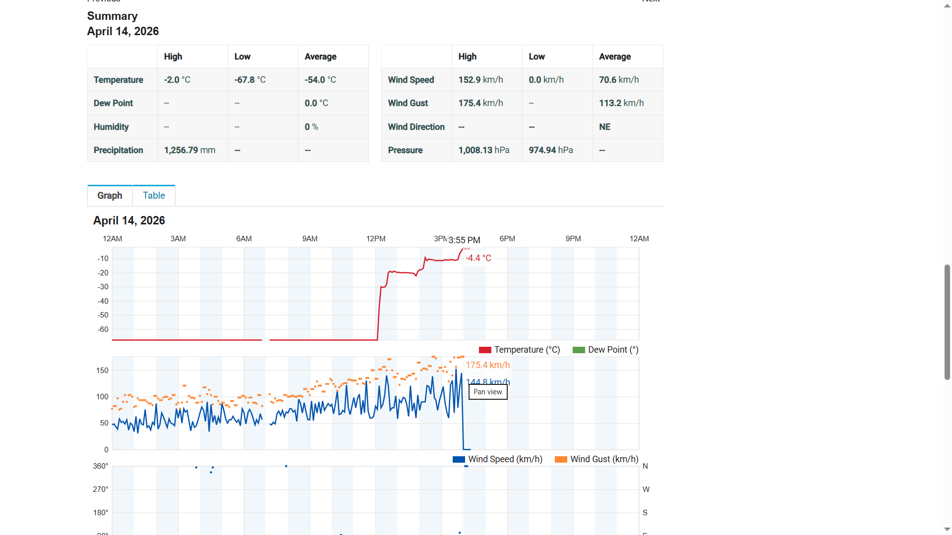
PGSN 141154Z AUTO 06071G113KT 1/2SM -RA FG VV003 26/26 RMK AO2 PK WND 050113/1151 RAB01RAEMMB40RAEMMB53 SLPNO P0026 60273 70532 T02560256 10261 20256 TSNO $
latest METAR has no pressure data but the wind data resumed
71 knots sustained gusting to 113 knots.
The obviously mis calibrated Davis Vantage AWS which appears consistently off by about 12.7 hPa compared to Ambient data near the airport is now registering a pressure of 945.82 hPa - so actual pressure must be in the low 930s now and dropping fast like a brick
0 likes
The posts in this forum are NOT official forecast and should not be used as such. They are just the opinion of the poster and may or may not be backed by sound meteorological data. They are NOT endorsed by any professional institution or storm2k.org. For official information, please refer to RSMC, NHC and NWS products.
-
cycloneye
- Admin
- Posts: 149708
- Age: 69
- Joined: Thu Oct 10, 2002 10:54 am
- Location: San Juan, Puerto Rico
Re: WPAC: SINLAKU - Typhoon
125 kt.
04W SINLAKU 260414 1200 14.9N 145.8E WPAC 125 930
04W SINLAKU 260414 1200 14.9N 145.8E WPAC 125 930
0 likes
Visit the Caribbean-Central America Weather Thread where you can find at first post web cams,radars
and observations from Caribbean basin members Click Here
and observations from Caribbean basin members Click Here
-
mrbagyo
- Category 5
- Posts: 3997
- Age: 33
- Joined: Thu Apr 12, 2012 9:18 am
- Location: 14.13N 120.98E
- Contact:
Re: WPAC: SINLAKU - Typhoon
cycloneye wrote:125 kt.
04W SINLAKU 260414 1200 14.9N 145.8E WPAC 125 930
This is absolutely deeper than 930 - Davis AWS near Capitol hill is already in 937.69 hPa and still dropping (gotta subtract at least 12 hPa)
1 likes
The posts in this forum are NOT official forecast and should not be used as such. They are just the opinion of the poster and may or may not be backed by sound meteorological data. They are NOT endorsed by any professional institution or storm2k.org. For official information, please refer to RSMC, NHC and NWS products.
-
cycloneye
- Admin
- Posts: 149708
- Age: 69
- Joined: Thu Oct 10, 2002 10:54 am
- Location: San Juan, Puerto Rico
Re: WPAC: SINLAKU - Typhoon
BULLETIN - EAS ACTIVATION REQUESTED
Extreme Wind Warning
National Weather Service Tiyan GU
916 PM ChST Tue Apr 14 2026
The National Weather Service in Tiyan Guam has issued a
* Extreme Wind Warning for...
Saipan
Tinian
* Until 1215 AM ChST.
* At 916 PM ChST, Andersen AFB Doppler radar indicated western edge
of the eyewall of Super Typhoon Sinlaku is moving into Tinian and
just south of Saipan. Winds up to 150 mph are possible. Sinlaku`s
forward speed is around 3 hour motion to the northwest, estimated
by radar. This slow motion means destructive winds in excess of
115 mph will be prolonged once they arrive and may extend further
into the overnight hours as the eye passes near or over Tinian and
Saipan. THIS IS AN EXTREMELY DANGEROUS AND LIFE-THREATENING
SITUATION!
PRECAUTIONARY/PREPAREDNESS ACTIONS...
Widespread destructive winds in excess of 115 mph are expected.
TAKE COVER NOW! Move immediately to an interior room in your
shelter. Take action now to protect your life!
The safest place to be during this situation is in a reinforced
interior room away from windows. Put as many walls between yourself
and the outside as possible. Remain in shelter through the passage
of these life-threatening conditions.
Do not venture out into the relative calm of the eye if it pass over
you. Extremely dangerous winds will soon return on the back side of
Super Typhoon Sinlaku.
0 likes
Visit the Caribbean-Central America Weather Thread where you can find at first post web cams,radars
and observations from Caribbean basin members Click Here
and observations from Caribbean basin members Click Here
-
cycloneye
- Admin
- Posts: 149708
- Age: 69
- Joined: Thu Oct 10, 2002 10:54 am
- Location: San Juan, Puerto Rico
Re: WPAC: SINLAKU - Typhoon
Eye over Saipan and Tianan.

1 likes
Visit the Caribbean-Central America Weather Thread where you can find at first post web cams,radars
and observations from Caribbean basin members Click Here
and observations from Caribbean basin members Click Here
-
Sciencerocks
- Category 5
- Posts: 10193
- Age: 40
- Joined: Thu Jul 06, 2017 1:51 am
Re: WPAC: SINLAKU - Typhoon
mrbagyo wrote:cycloneye wrote:125 kt.
04W SINLAKU 260414 1200 14.9N 145.8E WPAC 125 930
This is absolutely deeper than 930 - Davis AWS near Capitol hill is already in 937.69 hPa and still dropping (gotta subtract at least 12 hPa)
Looks like JMA went with 920 for the 12z analysis. What do you think?
2 likes
-
Sciencerocks
- Category 5
- Posts: 10193
- Age: 40
- Joined: Thu Jul 06, 2017 1:51 am

-
mrbagyo
- Category 5
- Posts: 3997
- Age: 33
- Joined: Thu Apr 12, 2012 9:18 am
- Location: 14.13N 120.98E
- Contact:
Re: WPAC: SINLAKU - Typhoon
ljmac75 wrote:mrbagyo wrote:cycloneye wrote:125 kt.
04W SINLAKU 260414 1200 14.9N 145.8E WPAC 125 930
This is absolutely deeper than 930 - Davis AWS near Capitol hill is already in 937.69 hPa and still dropping (gotta subtract at least 12 hPa)
Looks like JMA went with 920 for the 12z analysis. What do you think?
Must be between 910 and 920 at landfalls.
That Davis Vantage Pro 2 needs a visit to a pressure chamber for testing.

1 likes
The posts in this forum are NOT official forecast and should not be used as such. They are just the opinion of the poster and may or may not be backed by sound meteorological data. They are NOT endorsed by any professional institution or storm2k.org. For official information, please refer to RSMC, NHC and NWS products.

Re: WPAC: SINLAKU - Typhoon
mrbagyo wrote:ljmac75 wrote:mrbagyo wrote:
This is absolutely deeper than 930 - Davis AWS near Capitol hill is already in 937.69 hPa and still dropping (gotta subtract at least 12 hPa)
Looks like JMA went with 920 for the 12z analysis. What do you think?
Must be between 910 and 920 at landfalls.
That Davis Vantage Pro 2 needs a visit to a pressure chamber for testing.
That weather station you kindly linked was at 927.9 10 minutes ago. It's now at 930.2. May have bottomed out. Subtracting ~12 would put it at 915-918!
1 likes
-
mrbagyo
- Category 5
- Posts: 3997
- Age: 33
- Joined: Thu Apr 12, 2012 9:18 am
- Location: 14.13N 120.98E
- Contact:
Re: WPAC: SINLAKU - Typhoon
That 12 hPa is probably even conservative.
It needs a pressure chamber test at several pressure points to test the accuracy.
It needs a pressure chamber test at several pressure points to test the accuracy.
1 likes
The posts in this forum are NOT official forecast and should not be used as such. They are just the opinion of the poster and may or may not be backed by sound meteorological data. They are NOT endorsed by any professional institution or storm2k.org. For official information, please refer to RSMC, NHC and NWS products.
Return to “Active Storms - WestPAC/Asia”
Who is online
Users browsing this forum: No registered users and 101 guests