Atlantic Waves,Discussions and sat pics

This is the general tropical discussion area. Anyone can take their shot at predicting a storms path.

Moderator: S2k Moderators

Forum rules

The posts in this forum are NOT official forecasts and should not be used as such. They are just the opinion of the poster and may or may not be backed by sound meteorological data. They are NOT endorsed by any professional institution or STORM2K. For official information, please refer to products from the National Hurricane Center and National Weather Service.

Help Support Storm2K
Message
Author
User avatar
cycloneye
Admin
Admin
Posts: 145625
Age: 68
Joined: Thu Oct 10, 2002 10:54 am
Location: San Juan, Puerto Rico

#201 Postby cycloneye » Mon Jul 25, 2005 6:07 pm

Swimdude wrote:What's this i've been hearing about the Sahara dust storm? How will this affect development?


No Sal will not cap the rest of the season as somebody has said in another thread.An example is what is going on now. So take a look.

Image

As you can see the dust is well north of the corridor of waves that are emerging Africa.The waves are with moist air distint from the wave now near the lesser antilles which has been in an envelop of dust.Events of Sal are common this time of the year as the trade winds transport the dust thousands of miles westward.
0 likes   

User avatar
cycloneye
Admin
Admin
Posts: 145625
Age: 68
Joined: Thu Oct 10, 2002 10:54 am
Location: San Juan, Puerto Rico

#202 Postby cycloneye » Mon Jul 25, 2005 6:08 pm

http://www.nrlmry.navy.mil/sat-bin/disp ... C_SCALE=15

Great pic to look at the parade of waves.This pic updates every 15 minutes and can be animated.
0 likes   
Visit the Caribbean-Central America Weather Thread where you can find at first post web cams,radars
and observations from Caribbean basin members Click Here

User avatar
johngaltfla
Category 5
Category 5
Posts: 2069
Joined: Sun Jul 10, 2005 9:17 pm
Location: Sarasota County, FL
Contact:

#203 Postby johngaltfla » Mon Jul 25, 2005 6:23 pm

So it's safe to say that in 5-7 days, the CV Parade will be in full swing. Sad as it is to say, I just don't think that if we get storm after storm that our protective high will be there all season. If we see two storms forming per week, which I wouldn't dismiss as a possibility, there are going to be a lot of people freaking out along all of the American coastlines.
0 likes   

WeatherEmperor
S2K Supporter
S2K Supporter
Posts: 4806
Age: 41
Joined: Thu Sep 04, 2003 2:54 pm
Location: South Florida

#204 Postby WeatherEmperor » Mon Jul 25, 2005 6:39 pm

johngaltfla wrote:So it's safe to say that in 5-7 days, the CV Parade will be in full swing. Sad as it is to say, I just don't think that if we get storm after storm that our protective high will be there all season. If we see two storms forming per week, which I wouldn't dismiss as a possibility, there are going to be a lot of people freaking out along all of the American coastlines.


well in 1995 we had wave after wave come off Africa and develop into a named storm but not a single cape verde system made landfall on the US east coast with Felix giving NC a scare but thats about it.

<RICKY>
0 likes   

User avatar
cycloneye
Admin
Admin
Posts: 145625
Age: 68
Joined: Thu Oct 10, 2002 10:54 am
Location: San Juan, Puerto Rico

#205 Postby cycloneye » Mon Jul 25, 2005 6:41 pm

johngaltfla wrote:So it's safe to say that in 5-7 days, the CV Parade will be in full swing. Sad as it is to say, I just don't think that if we get storm after storm that our protective high will be there all season. If we see two storms forming per week, which I wouldn't dismiss as a possibility, there are going to be a lot of people freaking out along all of the American coastlines.


It's not a guarantee that in 5-7 days we will see Harvey,Irene,Jose,Katrina........... but chances are increasing as the time for the CV season to get going nears.
0 likes   
Visit the Caribbean-Central America Weather Thread where you can find at first post web cams,radars
and observations from Caribbean basin members Click Here

User avatar
johngaltfla
Category 5
Category 5
Posts: 2069
Joined: Sun Jul 10, 2005 9:17 pm
Location: Sarasota County, FL
Contact:

#206 Postby johngaltfla » Mon Jul 25, 2005 6:44 pm

cycloneye wrote:
johngaltfla wrote:So it's safe to say that in 5-7 days, the CV Parade will be in full swing. Sad as it is to say, I just don't think that if we get storm after storm that our protective high will be there all season. If we see two storms forming per week, which I wouldn't dismiss as a possibility, there are going to be a lot of people freaking out along all of the American coastlines.


It's not a guarantee that in 5-7 days we will see Harvey,Irene,Jose,Katrina........... but chances are increasing as the time for the CV season to get going nears.


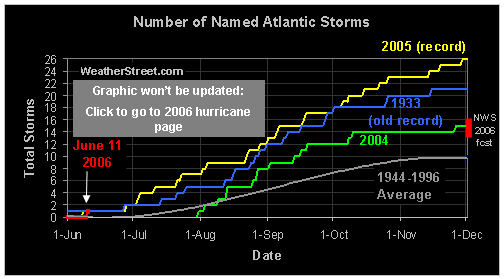
The funny thing is that I looked at that chart from another thread (this one)

Image

and IMHO, it does look like August is now July and August will be like September. But let's hope not.

Bottom line, and let me know if you disagree, is that we are in uncharted scientific and climatological territory and the predictability of any of these waves or the storms that emerge will get a bit flakier as the season progresses.
0 likes   

User avatar
cycloneye
Admin
Admin
Posts: 145625
Age: 68
Joined: Thu Oct 10, 2002 10:54 am
Location: San Juan, Puerto Rico

#207 Postby cycloneye » Mon Jul 25, 2005 6:48 pm

johngaltfla wrote:
cycloneye wrote:
johngaltfla wrote:So it's safe to say that in 5-7 days, the CV Parade will be in full swing. Sad as it is to say, I just don't think that if we get storm after storm that our protective high will be there all season. If we see two storms forming per week, which I wouldn't dismiss as a possibility, there are going to be a lot of people freaking out along all of the American coastlines.


It's not a guarantee that in 5-7 days we will see Harvey,Irene,Jose,Katrina........... but chances are increasing as the time for the CV season to get going nears.


The funny thing is that I looked at that chart from another thread (this one)

Image

and IMHO, it does look like August is now July and August will be like September. But let's hope not.

Bottom line, and let me know if you disagree, is that we are in uncharted scientific and climatological territory and the predictability of any of these waves or the storms that emerge will get a bit flakier as the season progresses.


As Forecaster Franklin said 2005 is not following climotology and that is a scary thought.
0 likes   
Visit the Caribbean-Central America Weather Thread where you can find at first post web cams,radars
and observations from Caribbean basin members Click Here

User avatar
cycloneye
Admin
Admin
Posts: 145625
Age: 68
Joined: Thu Oct 10, 2002 10:54 am
Location: San Juan, Puerto Rico

#208 Postby cycloneye » Mon Jul 25, 2005 6:55 pm

CENTRAL ATLC TROPICAL WAVE ALONG 32W/33W S OF 22N MOVING W 15-20
KT WITH A 1014 MB LOW ALONG THE WAVE NEAR 11N. THE LAST VISIBLE
SATELLITE PICTURES SHOWED A LARGE CIRCULATION ASSOCIATED WITH
THE WAVE WITH NO WELL-DEFINED CENTER. A RECENT QUIKSCAT
CONFIRMS THE LOCATION OF THE LOW THOUGH WINDS ASSOCIATED WITH
THE FEATURE ARE LESS THAN 20 KT. THERE IS A BIT OF DRY AIR
ENTRAINED INTO THE NORTHERN PART OF THE WAVE THAT IS PROBABLY
INHIBITING DEVELOPMENT AS ANY TSTMS HAVE BEEN WEAK AND
SHORT-LIVED. HOWEVER CONVECTION HAS BEEN INCREASING A LITTLE
TONIGHT NEAR THE CENTER WITH WIDELY SCATTERED MODERATE
CONVECTION FROM 8N-12N BETWEEN 33W-40W. COMPUTER MODELS SUGGEST
VERTICAL WIND SHEAR WILL REMAIN LOW AS THE WAVE MOVES WESTWARD
AND THE WAVE MAY HAVE SOME POTENTIAL FOR DEVELOPMENT AFTER IT
ENTERS WARMER WATERS W OF 40W.


8:05 PM Discussion.

Very interesting that wave is turning out.
0 likes   
Visit the Caribbean-Central America Weather Thread where you can find at first post web cams,radars
and observations from Caribbean basin members Click Here

User avatar
HURAKAN
Professional-Met
Professional-Met
Posts: 46086
Age: 38
Joined: Thu May 20, 2004 4:34 pm
Location: Key West, FL
Contact:

#209 Postby HURAKAN » Mon Jul 25, 2005 6:59 pm

Could we enter August with 8 named storms? Harvey, are you there? Many questions that only time will reveal the answer.
0 likes   

gkrangers

#210 Postby gkrangers » Mon Jul 25, 2005 7:03 pm

Possible...
0 likes   

WeatherEmperor
S2K Supporter
S2K Supporter
Posts: 4806
Age: 41
Joined: Thu Sep 04, 2003 2:54 pm
Location: South Florida

#211 Postby WeatherEmperor » Mon Jul 25, 2005 7:05 pm

We still have 6 days left in July and that is plenty time for another named storm to form.

<RICKY>
0 likes   

User avatar
cycloneye
Admin
Admin
Posts: 145625
Age: 68
Joined: Thu Oct 10, 2002 10:54 am
Location: San Juan, Puerto Rico

#212 Postby cycloneye » Mon Jul 25, 2005 7:07 pm

A 1024 MB HIGH IS
NEAR 30N40W RIDGING ESE TO 25N18W AND WSW TO 26N55W THEN
24N66W. WITH A RATHER NEGATIVE NAO AND ACTIVE MID-LATITUDE
PATTERN...PRESSURES ARE EXTREMELY LOW IN THE SUBTROPICAL RIDGE
WITH CORRESPONDINGLY LIGHT TRADES IN THE TROPICAL ATLC.

$$
BLAKE


Look what Forecaster Blake said at the end of discussion about the NAO and the weak subtropical ridge.
0 likes   
Visit the Caribbean-Central America Weather Thread where you can find at first post web cams,radars
and observations from Caribbean basin members Click Here

DoctorHurricane2003

#213 Postby DoctorHurricane2003 » Mon Jul 25, 2005 7:21 pm

Actually it doesn't say 'weak' it says 'pressures are low in the high' which is the corresponding opposite of having a 1000 mb hurricane. Its a high pressure in a low pressure environment. :)
0 likes   

User avatar
sweetpea
S2K Supporter
S2K Supporter
Posts: 858
Age: 58
Joined: Fri Jun 10, 2005 5:49 pm
Location: Sopchoppy, FL

#214 Postby sweetpea » Mon Jul 25, 2005 7:25 pm

What does NAO stand for?
0 likes   

User avatar
cycloneye
Admin
Admin
Posts: 145625
Age: 68
Joined: Thu Oct 10, 2002 10:54 am
Location: San Juan, Puerto Rico

#215 Postby cycloneye » Mon Jul 25, 2005 7:26 pm

sweetpea wrote:What does NAO stand for?


North Atlantic Occillation

North Atlantic Oscillation / Pacific - North American pattern (NAO/PNA)


Calculating the Daily PNA and NAO teleconnection indices

The calculation procedure and base period have changed for calculating the daily NAO and PNA teleconnection indices. These changes have been made to eliminate inconsistencies in the way that the monthly and daily indices are calculated.

The procedure used to calculate the daily PNA and NAO teleconnection indices is based on the Rotated Principal Component Analysis (RPCA) used by Barnston and Livezey (1987, Mon. Wea. Rev., 115, 1083-1126). This procedure isolates the primary teleconnection patterns for all months and allows time series of the patterns to be constructed. To obtain the teleconnection patterns, the RPCA technique is applied to monthly standardized 500-mb height anomalies obtained from the CDAS in the analysis region 20°N-90°N between January 1950 and December 2000. Click here for more information on the teleconnection pattern calculation procedures.

The monthly teleconnection patterns are now linearly interpolated to the day in question, and therefore account for the seasonality inherent in the NAO and PNA patterns. Previously, the annual mean PNA and NAO patterns were used, which were based on monthly non-standardized anomalies. The standardized anomalies are now calculated based on the 1950-2000 climatological daily mean and standard deviation, whereas the anomalies were previously calculated from the 1971-2000 base period daily means.

The daily teleconnection indices are now calculated using the Least Squares regression approach identical to that used for the monthly indices. Therefore, all of the teleconnection patterns valid for the day in question are now recognized when calculating the PNA and NAO indices. The daily indices now represent the combination of teleconnection patterns that accounts for the most spatial variance of the observed anomaly map on any given day. Previously, the indices represented the spatial correlation between the annual mean loading pattern of the NAO or PNA and the daily height anomalies, and did not account for the spatial overlap that exists amongst the various teleconnection patterns.


Above is a complete explanation about what is NAO.
Last edited by cycloneye on Mon Jul 25, 2005 7:32 pm, edited 1 time in total.
0 likes   
Visit the Caribbean-Central America Weather Thread where you can find at first post web cams,radars
and observations from Caribbean basin members Click Here

User avatar
sweetpea
S2K Supporter
S2K Supporter
Posts: 858
Age: 58
Joined: Fri Jun 10, 2005 5:49 pm
Location: Sopchoppy, FL

#216 Postby sweetpea » Mon Jul 25, 2005 7:31 pm

WITH A RATHER NEGATIVE NAO AND ACTIVE MID-LATITUDE
PATTERN.

Thanks cycloneye. Is this good or bad? Will this hinder development or make it easier for storms to develop? Thanks for any responses.
Debbie
0 likes   

OURAGAN
Category 1
Category 1
Posts: 452
Joined: Sat Aug 07, 2004 12:18 pm
Location: GUADELOUPE

#217 Postby OURAGAN » Mon Jul 25, 2005 7:47 pm

For Cycloneye and the others members another good picture much better than the icture of LSU.
It's updated every fifteen minutes
Here is the link:
http://www.nrlmry.navy.mil/sat-bin/disp ... C_SCALE=15
0 likes   

User avatar
wxmann_91
Category 5
Category 5
Posts: 8013
Age: 34
Joined: Fri Jul 15, 2005 2:49 pm
Location: Southern California
Contact:

#218 Postby wxmann_91 » Mon Jul 25, 2005 7:53 pm

sweetpea wrote:WITH A RATHER NEGATIVE NAO AND ACTIVE MID-LATITUDE
PATTERN.

Thanks cycloneye. Is this good or bad? Will this hinder development or make it easier for storms to develop? Thanks for any responses.
Debbie


FWIW, I think that an active subtropics would lessen the threat to the western Caribbean and the Gulf Coast but increase the possibility of Bahamas and east coast impact and for the system to be a fish.

EDIT: I have no idea of whether this would impact storms forming in the tropical Atlantic, but it would lessen the threat of a storm forming in the subtropical Atlantic.
0 likes   

User avatar
cycloneye
Admin
Admin
Posts: 145625
Age: 68
Joined: Thu Oct 10, 2002 10:54 am
Location: San Juan, Puerto Rico

#219 Postby cycloneye » Mon Jul 25, 2005 9:14 pm

Image

The parade of waves continues in full gear.
0 likes   
Visit the Caribbean-Central America Weather Thread where you can find at first post web cams,radars
and observations from Caribbean basin members Click Here

User avatar
Hyperstorm
Category 5
Category 5
Posts: 1500
Joined: Sun Sep 07, 2003 3:48 am
Location: Ocala, FL

#220 Postby Hyperstorm » Mon Jul 25, 2005 9:20 pm

Just wanted to post a very quick update...

It appears that the other circulation further north has become detached and moved over cooler waters. So, don't expect development from that northern part. The southern part is the one I'm watching now as it appears to be slowly getting organized near 10N 38W. If current trends continue, we could get an invest as early as tomorrow because it certainly has indicated some good circulation with it. That feature is over MUCH warmer waters than the earlier feature.

The wave behind it hasn't done much as expected and I don't expect any development, until it moves MUCH further west (if there's going to be any).

The next one is ready to move offshore tomorrow...
0 likes   


Return to “Talkin' Tropics”

Who is online

Users browsing this forum: HurakaYoshi, Kennethb, Steve H., Xlhunter3 and 394 guests