Area in the Northwestern Caribbean Sea

This is the general tropical discussion area. Anyone can take their shot at predicting a storms path.

Moderator: S2k Moderators

Forum rules

The posts in this forum are NOT official forecasts and should not be used as such. They are just the opinion of the poster and may or may not be backed by sound meteorological data. They are NOT endorsed by any professional institution or STORM2K. For official information, please refer to products from the National Hurricane Center and National Weather Service.

Help Support Storm2K
Message
Author
AutoPenalti
Category 5
Category 5
Posts: 3950
Age: 27
Joined: Mon Aug 17, 2015 4:16 pm
Location: Ft. Lauderdale, Florida

Re: Disturbed weather ESE of the Windward Islands

#101 Postby AutoPenalti » Tue Aug 23, 2022 2:44 pm

Blown Away wrote:https://i.imgur.com/oK6I5SG.png
12z GFS ensembles, seems there are 2 camps with this disturbed weather:

Develop E of the islands and generally move towards GA, Bahamas. CONUS.

Stay a TW into W Caribbean and then into CA or stronger members towards Texas...

For the eastern solutions to verify, it would need to develop a core within... *checks watch*


12 hours.
0 likes   
The posts in this forum are NOT official forecasts and should not be used as such. They are just the opinion of the poster and may or may not be backed by sound meteorological data. They are NOT endorsed by any professional institution or STORM2K. For official information, please refer to products from the NHC and NWS.


Model Runs Cheat Sheet:
GFS (5:30 AM/PM, 11:30 AM/PM)
HWRF, GFDL, UKMET, NAVGEM (6:30-8:00 AM/PM, 12:30-2:00 AM/PM)
ECMWF (1:45 AM/PM)

TCVN
is a weighted averaged

User avatar
Clearcloudz
Category 2
Category 2
Posts: 523
Joined: Sun Jun 10, 2018 1:46 pm
Location: Rosenberg TX

Re: Disturbed weather ESE of the Windward Islands

#102 Postby Clearcloudz » Tue Aug 23, 2022 2:47 pm

12Z Euro Ensembles
Image
0 likes   

Deshaunrob17
Tropical Storm
Tropical Storm
Posts: 185
Joined: Tue Aug 18, 2020 7:49 am

Re: Disturbed weather ESE of the Windward Islands

#103 Postby Deshaunrob17 » Tue Aug 23, 2022 2:53 pm

SouthFLTropics wrote:I've heard two C storms mentioned in the last few minutes. Cleo and Charley, shown below for reference.
CLEO 1964
https://i.imgur.com/Kw8sdgs.png

CHARLEY 2004
https://i.imgur.com/T31eOuM.png


For some reason I always thought Charlie was one of those traditional cruisers…. Looks like one of those system we’ve seen a lot of since 2016…
0 likes   

User avatar
skyline385
Category 5
Category 5
Posts: 2506
Age: 33
Joined: Wed Aug 26, 2020 11:15 pm
Location: Houston TX

Re: Disturbed weather ESE of the Windward Islands

#104 Postby skyline385 » Tue Aug 23, 2022 3:01 pm

Blown Away wrote:Image
12z GFS ensembles, seems there are 2 camps with this disturbed weather:

Develop E of the islands and generally move towards GA, Bahamas. CONUS.

Stay a TW into W Caribbean and then into CA or stronger members towards Texas...

The 2nd group also has several members hitting the panhandle similar to the operational run.


Sent from my iPhone using Tapatalk
0 likes   

User avatar
NDG
S2K Supporter
S2K Supporter
Posts: 14934
Joined: Sun Jul 09, 2006 10:14 pm
Location: Orlando, FL

Re: Disturbed weather ESE of the Windward Islands

#105 Postby NDG » Tue Aug 23, 2022 3:08 pm

A definite growing support for a Caribbean development by the Euro ensembles during the past couple of days.

Image
2 likes   

User avatar
MHC Tracking
Tropical Storm
Tropical Storm
Posts: 170
Joined: Mon Mar 15, 2021 10:05 am

Re: Disturbed weather ESE of the Windward Islands

#106 Postby MHC Tracking » Tue Aug 23, 2022 3:35 pm

wxman57 wrote:I'm sure that the GFS is right THIS time. Go back to previous runs on Tropical Tidbits and search for any consistency. Almost certainly another modelcane. Besides, I cancelled hurricane season so I could get some rest.

Ah yes, the "modelcane" with a precursor that's already active that GFS develops at TAU 96, and has an NHC AOI. I too doubt the 12z GFS (for obvious reasons) but I feel like dismissing this as a "modelcane" may not age so well in the coming days.
6 likes   

User avatar
Yellow Evan
Professional-Met
Professional-Met
Posts: 15956
Age: 25
Joined: Fri Jul 15, 2011 12:48 pm
Location: Henderson, Nevada/Honolulu, HI
Contact:

Re: Disturbed weather ESE of the Windward Islands

#107 Postby Yellow Evan » Tue Aug 23, 2022 3:51 pm

Kingarabian wrote:Isn't this the same system the CMC and the GFS were developing and affecting the GOM, last week?


No, believe that AEW is crossing Central America rn.
0 likes   

User avatar
SFLcane
S2K Supporter
S2K Supporter
Posts: 9617
Age: 46
Joined: Sat Jun 05, 2010 1:44 pm
Location: Lake Worth Florida

Re: Disturbed weather ESE of the Windward Islands

#108 Postby SFLcane » Tue Aug 23, 2022 3:52 pm

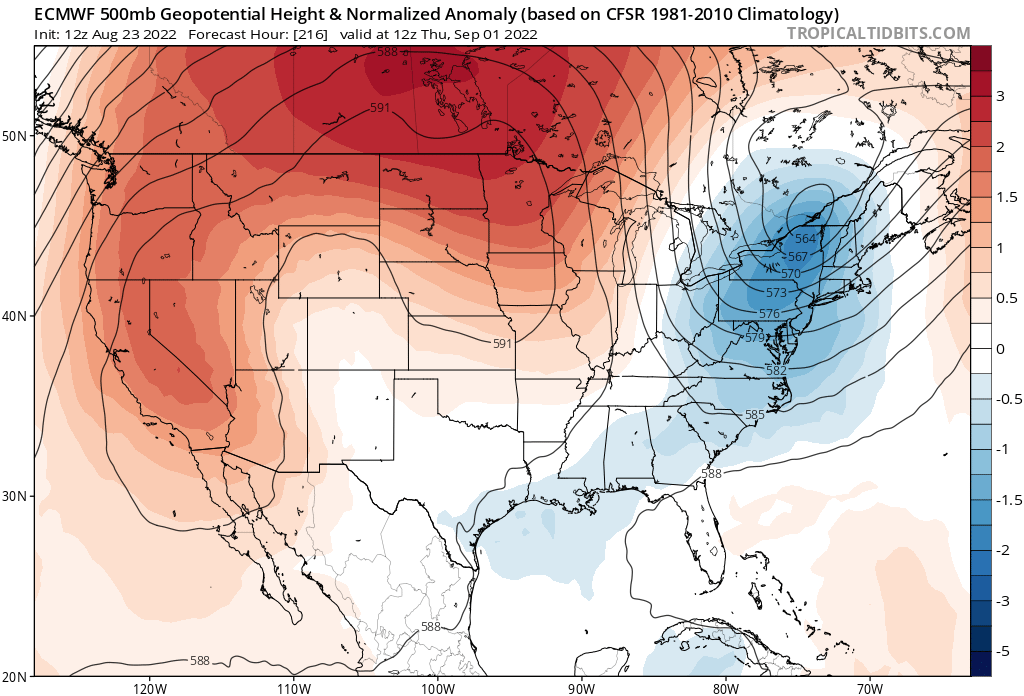
Not sure what affect it will have but the EC also has a digging trof as the same time the gfs has. Could act to bring whatever is down there especially if its strong tc eventually north.

Image
0 likes   

User avatar
Yellow Evan
Professional-Met
Professional-Met
Posts: 15956
Age: 25
Joined: Fri Jul 15, 2011 12:48 pm
Location: Henderson, Nevada/Honolulu, HI
Contact:

Re: Disturbed weather ESE of the Windward Islands

#109 Postby Yellow Evan » Tue Aug 23, 2022 3:54 pm

wxman57 wrote:I'm sure that the GFS is right THIS time. Go back to previous runs on Tropical Tidbits and search for any consistency. Almost certainly another modelcane. Besides, I cancelled hurricane season so I could get some rest.


The origins of this system and the other phantoms are very different because the others were monsoon trough born, which the GFS is famous for overdoing in other basins, so this seems like a false comparison
5 likes   

User avatar
KWT
Category 5
Category 5
Posts: 31391
Joined: Tue Aug 17, 2004 11:02 am
Location: UK!!!

Re: Disturbed weather ESE of the Windward Islands

#110 Postby KWT » Tue Aug 23, 2022 4:12 pm

sma10 wrote:
lsuhurricane wrote:Euro ensembles appear to ramp this up near Jamaica, albeit on a much more western approach. Very active, similar to 0z ensembles. Perhaps a bit more eastern based. Multiple hurricanes in the GOM on this run. Looks like we've got a player.


But what percentage of the 51 members actually show development?


I counted 18 runs out of 51 of the ensembles that have at least 1 closed isobar and obviously develops from this area. There are a few that actually form from a different area that are on the more easterly track that I've not counted. Some of these become quite strong storms as well.

That is up 4 members from the 00z which had 14 using the same metric.
0 likes   
Personal Forecast Disclaimer:
The posts in this forum are NOT official forecast and should not be used as such. They are just the opinion of the poster and may or may not be backed by sound meteorological data. They are NOT endorsed by any professional institution or storm2k.org. For official information, please refer to the NHC and NWS products

User avatar
skyline385
Category 5
Category 5
Posts: 2506
Age: 33
Joined: Wed Aug 26, 2020 11:15 pm
Location: Houston TX

Re: Disturbed weather ESE of the Windward Islands

#111 Postby skyline385 » Tue Aug 23, 2022 4:33 pm

18Z ICON, GFS coming up

Image


Sent from my iPhone using Tapatalk
0 likes   

BobHarlem
Category 5
Category 5
Posts: 1665
Joined: Thu Oct 20, 2005 6:11 pm

Re: Disturbed weather ESE of the Windward Islands

#112 Postby BobHarlem » Tue Aug 23, 2022 5:05 pm

So far the 18z gfs is coming in notably weaker at 102 hours out.
0 likes   

User avatar
skyline385
Category 5
Category 5
Posts: 2506
Age: 33
Joined: Wed Aug 26, 2020 11:15 pm
Location: Houston TX

Re: Disturbed weather ESE of the Windward Islands

#113 Postby skyline385 » Tue Aug 23, 2022 5:07 pm

Yea weaker run so far but the system is still there

Sent from my LM-V405 using Tapatalk
0 likes   

User avatar
Hurricaneman
Category 5
Category 5
Posts: 7284
Age: 43
Joined: Tue Aug 31, 2004 3:24 pm
Location: central florida

Re: Disturbed weather ESE of the Windward Islands

#114 Postby Hurricaneman » Tue Aug 23, 2022 5:09 pm

BobHarlem wrote:So far the 18z gfs is coming in notably weaker at 102 hours out.


Seems to try to develop before the lesser Antilles but gets caught in the trades of the eastern Caribbean graveyard before developing farther west is my feeling looking at this
0 likes   

User avatar
aspen
Category 5
Category 5
Posts: 8057
Joined: Sat Oct 12, 2019 7:10 pm
Location: Connecticut, USA

Re: Disturbed weather ESE of the Windward Islands

#115 Postby aspen » Tue Aug 23, 2022 5:11 pm

BobHarlem wrote:So far the 18z gfs is coming in notably weaker at 102 hours out.

Looks like some of the phantom Venezuelan vorticity gets caught in it around 120hrs out.
0 likes   
Irene '11 Sandy '12 Hermine '16 5/15/2018 Derecho Fay '20 Isaias '20 Elsa '21 Henri '21 Ida '21

I am only a meteorology enthusiast who knows a decent amount about tropical cyclones. Look to the professional mets, the NHC, or your local weather office for the best information.

User avatar
skyline385
Category 5
Category 5
Posts: 2506
Age: 33
Joined: Wed Aug 26, 2020 11:15 pm
Location: Houston TX

Re: RE: Re: Disturbed weather ESE of the Windward Islands

#116 Postby skyline385 » Tue Aug 23, 2022 5:11 pm

Hurricaneman wrote:
BobHarlem wrote:So far the 18z gfs is coming in notably weaker at 102 hours out.


Seems to try to develop before the lesser Antilles but gets caught in the trades of the eastern Caribbean graveyard before developing farther west is my feeling looking at this
Looking at the vorticity plots, seems like the TCG was just slower this run

Sent from my LM-V405 using Tapatalk
0 likes   

User avatar
skyline385
Category 5
Category 5
Posts: 2506
Age: 33
Joined: Wed Aug 26, 2020 11:15 pm
Location: Houston TX

Re: Disturbed weather ESE of the Windward Islands

#117 Postby skyline385 » Tue Aug 23, 2022 5:13 pm

It is much further south this run and should avoid contact with Cuba though if it's able to consolidate

Sent from my LM-V405 using Tapatalk
0 likes   

User avatar
skyline385
Category 5
Category 5
Posts: 2506
Age: 33
Joined: Wed Aug 26, 2020 11:15 pm
Location: Houston TX

Re: Disturbed weather ESE of the Windward Islands

#118 Postby skyline385 » Tue Aug 23, 2022 5:16 pm

The centers seem to be way misaligned, looks like it's getting sheared?

Sent from my LM-V405 using Tapatalk
0 likes   

User avatar
gatorcane
S2K Supporter
S2K Supporter
Posts: 23499
Age: 46
Joined: Sun Mar 13, 2005 3:54 pm
Location: Boca Raton, FL

Re: Disturbed weather ESE of the Windward Islands

#119 Postby gatorcane » Tue Aug 23, 2022 5:18 pm

This is not the same GFS we are used to. One run it develops something into a hurricane, next run a weak low even in the short to medium range. Unless the EC and/or CMC show something similar you can toss the GFS model out. The Eastern Caribbean is a tough place for genesis to happen, it doesn’t take a model to show that.
2 likes   

User avatar
SoupBone
Category 5
Category 5
Posts: 3073
Joined: Tue Sep 20, 2005 5:24 pm

Re: Disturbed weather ESE of the Windward Islands

#120 Postby SoupBone » Tue Aug 23, 2022 5:20 pm

gatorcane wrote:This is not the same GFS we are used to. One run it develops something into a hurricane, next run a weak low even in the short to medium range. Unless the EC and/or CMC show something similar you can toss the GFS model out. The Eastern Caribbean is a tough place for genesis to happen, it doesn’t take a model to show that.


The absolute inconsistency of the GFS has been mentioned by a few people here.
2 likes   
Personal Forecast Disclaimer:
The posts in this forum are NOT official forecast and should not be used as such. They are just the opinion of the poster and may or may not be backed by sound meteorological data. They are NOT endorsed by any professional institution or storm2k.org. For official information, please refer to the NHC and NWS products.


Return to “Talkin' Tropics”

Who is online

Users browsing this forum: Google [Bot], Google Adsense [Bot], South Texas Storms, Tireman4 and 47 guests