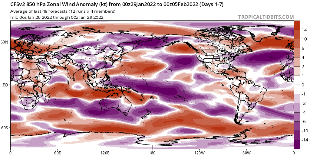
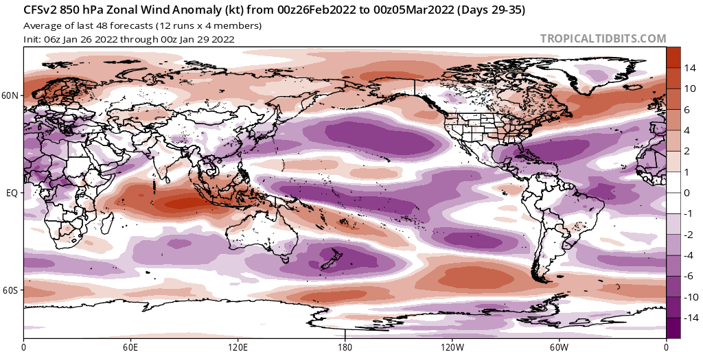
The CFS depiction would put a big dent on El Nino chances for 2022:

Moderator: S2k Moderators


Kingarabian wrote:Well NCEP models looks to be verifying here compared to the Euro. MJO likely to come out stronger over the IO vs the WPAC and now both the CFS and Euro models have stout trade bursts over the dateline.
The CFS depiction would put a big dent on El Nino chances for 2022:
https://i.imgur.com/x7pn4vP.png


WiscoWx02 wrote:Kingarabian wrote:Well NCEP models looks to be verifying here compared to the Euro. MJO likely to come out stronger over the IO vs the WPAC and now both the CFS and Euro models have stout trade bursts over the dateline.
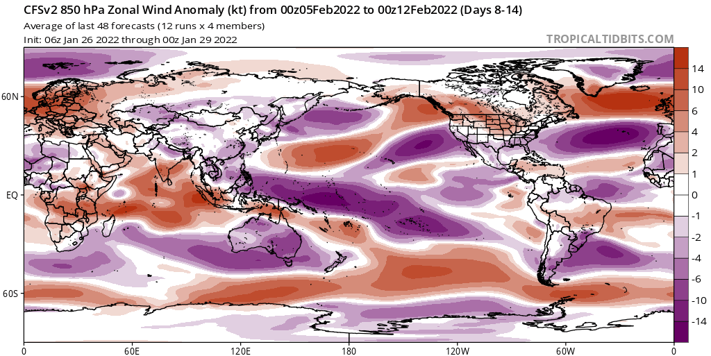
The CFS depiction would put a big dent on El Nino chances for 2022:
https://i.imgur.com/x7pn4vP.png
So THIS is why it is showing La Nina lasting through summer 2022? I mean, if La Nina actually lasts through spring and summer without giving away to EL Nino I would be extremely shocked at this point but an interesting look at how the ENSO may evolve nonetheless.


WiscoWx02 wrote:Kingarabian wrote:Well NCEP models looks to be verifying here compared to the Euro. MJO likely to come out stronger over the IO vs the WPAC and now both the CFS and Euro models have stout trade bursts over the dateline.
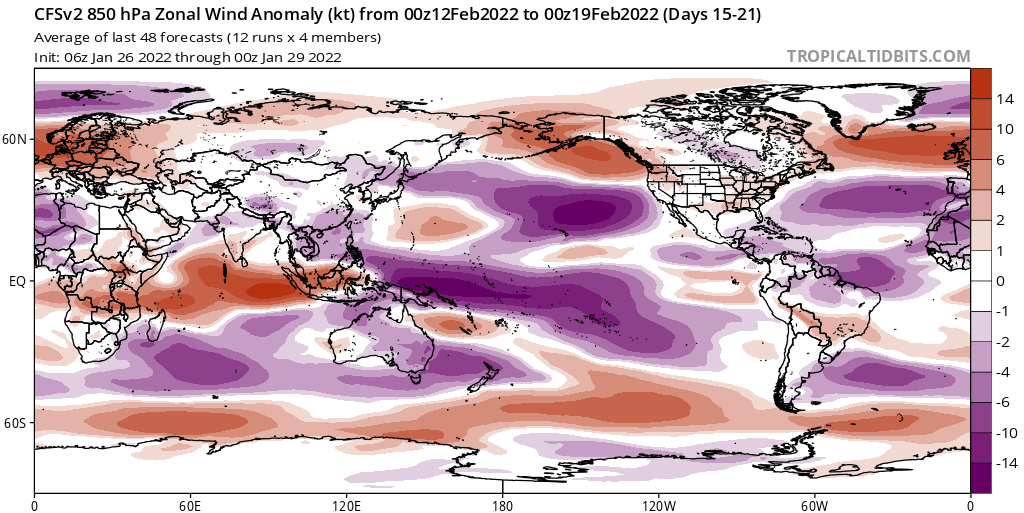
The CFS depiction would put a big dent on El Nino chances for 2022:
https://i.imgur.com/x7pn4vP.png
So THIS is why it is showing La Nina lasting through summer 2022? I mean, if La Nina actually lasts through spring and summer without giving away to EL Nino I would be extremely shocked at this point but an interesting look at how the ENSO may evolve nonetheless.


Kingarabian wrote:WiscoWx02 wrote:Kingarabian wrote:Well NCEP models looks to be verifying here compared to the Euro. MJO likely to come out stronger over the IO vs the WPAC and now both the CFS and Euro models have stout trade bursts over the dateline.
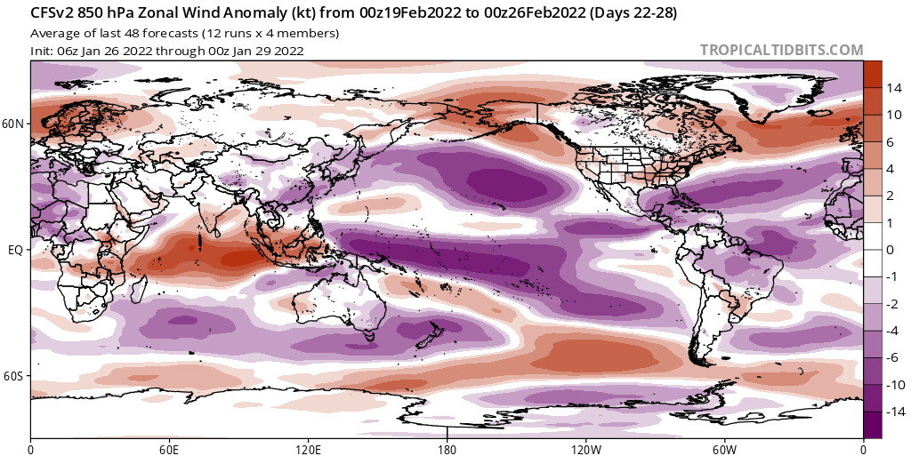
The CFS depiction would put a big dent on El Nino chances for 2022:
https://i.imgur.com/x7pn4vP.png
So THIS is why it is showing La Nina lasting through summer 2022? I mean, if La Nina actually lasts through spring and summer without giving away to EL Nino I would be extremely shocked at this point but an interesting look at how the ENSO may evolve nonetheless.
Regarding the ocean component of ENSO, La Nina will be over soon since the surface temperaturs are likely to warm between March and April due to an erupting downwelling KW. But to get an El Nino you need a steady stream of warm water from the WPAC to the EPAC. The issue with a strong February trade burst and not a WWB, is that it likely means we won't see another downwelling KW forming and reaching the EPAC by June. So when the July trade winds go into overdrive, the lack of subsurface (and eventually the surface temperatures) warmth in place means an easier chance for -ENSO or La Nina to resurface by ASO.
This could change if we get a spring WWB over the dateline but it doesn't seem likely and those are rare without an El Nino transition in place.
It still seems the atmosphere is tilted towards La Nina. That's a big WWB over the IO.
NotSparta wrote:Kingarabian wrote:WiscoWx02 wrote:
So THIS is why it is showing La Nina lasting through summer 2022? I mean, if La Nina actually lasts through spring and summer without giving away to EL Nino I would be extremely shocked at this point but an interesting look at how the ENSO may evolve nonetheless.
Regarding the ocean component of ENSO, La Nina will be over soon since the surface temperaturs are likely to warm between March and April due to an erupting downwelling KW. But to get an El Nino you need a steady stream of warm water from the WPAC to the EPAC. The issue with a strong February trade burst and not a WWB, is that it likely means we won't see another downwelling KW forming and reaching the EPAC by June. So when the July trade winds go into overdrive, the lack of subsurface (and eventually the surface temperatures) warmth in place means an easier chance for -ENSO or La Nina to resurface by ASO.
This could change if we get a spring WWB over the dateline but it doesn't seem likely and those are rare without an El Nino transition in place.
It still seems the atmosphere is tilted towards La Nina. That's a big WWB over the IO.
Yeah I'm wondering what happens in March. You get a lot of El Niños really start then with a WPAC MJO event that causes a WWB. Still too early to see how it will be then. Door is definitely still open for El Niño but if there isn't a WWB by the beginning of spring then that door will start closing

Kingarabian wrote:NotSparta wrote:Kingarabian wrote:
Regarding the ocean component of ENSO, La Nina will be over soon since the surface temperaturs are likely to warm between March and April due to an erupting downwelling KW. But to get an El Nino you need a steady stream of warm water from the WPAC to the EPAC. The issue with a strong February trade burst and not a WWB, is that it likely means we won't see another downwelling KW forming and reaching the EPAC by June. So when the July trade winds go into overdrive, the lack of subsurface (and eventually the surface temperatures) warmth in place means an easier chance for -ENSO or La Nina to resurface by ASO.
This could change if we get a spring WWB over the dateline but it doesn't seem likely and those are rare without an El Nino transition in place.
It still seems the atmosphere is tilted towards La Nina. That's a big WWB over the IO.
Yeah I'm wondering what happens in March. You get a lot of El Niños really start then with a WPAC MJO event that causes a WWB. Still too early to see how it will be then. Door is definitely still open for El Niño but if there isn't a WWB by the beginning of spring then that door will start closing
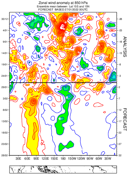
Although this can easily change, the 90 day CFS still doesn't show a WWB in March-April despite that model's biases and the MJO probably moving into the Pacific around then.
This trade burst looks like it will spawn a pretty good upwelling KW. So it's possible that a even March-April WWB fails to offset it. I don't recall in our most recent El Nino fails in 2017, 2021 having strong trades like this in February.
https://i.imgur.com/0DKRhL6.png
Kingarabian wrote:NotSparta wrote:Kingarabian wrote:
Regarding the ocean component of ENSO, La Nina will be over soon since the surface temperaturs are likely to warm between March and April due to an erupting downwelling KW. But to get an El Nino you need a steady stream of warm water from the WPAC to the EPAC. The issue with a strong February trade burst and not a WWB, is that it likely means we won't see another downwelling KW forming and reaching the EPAC by June. So when the July trade winds go into overdrive, the lack of subsurface (and eventually the surface temperatures) warmth in place means an easier chance for -ENSO or La Nina to resurface by ASO.
This could change if we get a spring WWB over the dateline but it doesn't seem likely and those are rare without an El Nino transition in place.
It still seems the atmosphere is tilted towards La Nina. That's a big WWB over the IO.
Yeah I'm wondering what happens in March. You get a lot of El Niños really start then with a WPAC MJO event that causes a WWB. Still too early to see how it will be then. Door is definitely still open for El Niño but if there isn't a WWB by the beginning of spring then that door will start closing
Although this can easily change, the 90 day CFS still doesn't show a WWB in March-April despite that model's biases and the MJO probably moving into the Pacific around then.
This trade burst looks like it will spawn a pretty good upwelling KW. So it's possible that a even March-April WWB fails to offset it. I don't recall in our most recent El Nino fails in 2017, 2021 having strong trades like this in February.
https://i.imgur.com/0DKRhL6.png


Yellow Evan wrote:Credibility that these models have towards ENSO especially beyond the 45 time frame or so? Zilch.
Kingarabian wrote:Unless we get another 2009 type El Nino that comes on super late in the spring period, the writing is on the wall for a 2022 El Nino. Yeah the models aren't reliable in this time period so we don't know what's going to happen in March, but that doesn't matter because we will see a month long February trade burst and not a WWB. An ideal situation for an El Nino was either a February WWB or simply relaxed trades. Not an uptick in trades.
To me this means:
1. La Nina atmospheric forcing is still in control despite the Nino regions eventually warming.
2. Likely upwelling favored and not downwelling for the next couple of months, a sensitive time for El Nino formation. So when this present downwelling KW is in the EPAC, it could be followed by a pool of cool waters.
It was tough anyway with a -PDO/-PMM regime.
AlphaToOmega wrote:Kingarabian wrote:Unless we get another 2009 type El Nino that comes on super late in the spring period, the writing is on the wall for a 2022 El Nino. Yeah the models aren't reliable in this time period so we don't know what's going to happen in March, but that doesn't matter because we will see a month long February trade burst and not a WWB. An ideal situation for an El Nino was either a February WWB or simply relaxed trades. Not an uptick in trades.
To me this means:
1. La Nina atmospheric forcing is still in control despite the Nino regions eventually warming.
2. Likely upwelling favored and not downwelling for the next couple of months, a sensitive time for El Nino formation. So when this present downwelling KW is in the EPAC, it could be followed by a pool of cool waters.
It was tough anyway with a -PDO/-PMM regime.
The door for an El Niño has not closed just yet. It is not common, but there have been El Niño years that featured easterly winds in the equatorial Pacific. We are not going to know for sure the ENSO state of the 2022-2023 winter for a while.
https://i.postimg.cc/P5f9RbvG/Yg-NCc-D9d3k.png

Users browsing this forum: BigB0882, cainjamin, cheezyWXguy, Cpv17, duilaslol, idaknowman, jgh, MetroMike, ScottNAtlanta, skyline385, TheAustinMan, Wampadawg and 86 guests


