https://twitter.com/wx_tiger/status/1535328203794956289
https://weathertiger.substack.com/p/rea ... ricane?s=w
Moderator: S2k Moderators


cycloneye wrote:Hey Adrian.ACE up to 175.
https://twitter.com/wx_tiger/status/1535328203794956289
https://weathertiger.substack.com/p/rea ... ricane?s=w

cycloneye wrote:Hey Adrian.
https://twitter.com/wx_tiger/status/1535328203794956289
https://weathertiger.substack.com/p/rea ... ricane?s=w


aspen wrote:TWC has upgraded its forecast to 21/9/4. Unfortunately, I can’t try getting the link to the article without going to the app.

cycloneye wrote:https://i.imgur.com/52i20AI.jpg


Teban54 wrote:cycloneye wrote:https://i.imgur.com/52i20AI.jpg
This is 2021 though?

skyline385 wrote:Teban54 wrote:cycloneye wrote:https://i.imgur.com/52i20AI.jpg
This is 2021 though?
Here’s a SS of the latest one from my phone
https://uploads.tapatalk-cdn.com/20220705/2d89b833d935f29f21bf8d95451f7dfc.png
zzh wrote:The current forecast for the JulySeptember trade wind is for 0.77±0.80 ms-1 weaker than normal (1991-2020 climatology). The current forecast for the August-September SST is for 0.25±0.33°C warmer than normal (1991-2020 climatology)
TSR forecast weaker winds and warmer sst compared to May forecast.


al78 wrote:zzh wrote:The current forecast for the JulySeptember trade wind is for 0.77±0.80 ms-1 weaker than normal (1991-2020 climatology). The current forecast for the August-September SST is for 0.25±0.33°C warmer than normal (1991-2020 climatology)
TSR forecast weaker winds and warmer sst compared to May forecast.
We also took into account the early development of a potential tropical cyclone in the MDR and tropical storm in the Caribbean Sea.
wxman57 wrote:al78 wrote:zzh wrote:The current forecast for the JulySeptember trade wind is for 0.77±0.80 ms-1 weaker than normal (1991-2020 climatology). The current forecast for the August-September SST is for 0.25±0.33°C warmer than normal (1991-2020 climatology)
TSR forecast weaker winds and warmer sst compared to May forecast.
We also took into account the early development of a potential tropical cyclone in the MDR and tropical storm in the Caribbean Sea.
There was no actual development in the MDR. Bonnie developed in the SW Caribbean, which is a common area for development early in the season. PTC advisories have been issued only recently to cover a wave that MAY develop and impact land within 48 hrs.

wxman57 wrote:al78 wrote:zzh wrote:The current forecast for the JulySeptember trade wind is for 0.77±0.80 ms-1 weaker than normal (1991-2020 climatology). The current forecast for the August-September SST is for 0.25±0.33°C warmer than normal (1991-2020 climatology)
TSR forecast weaker winds and warmer sst compared to May forecast.
We also took into account
the early development of a potential tropical cyclone in the MDR and tropical storm in the Caribbean Sea.
There was no actual development in the MDR. Bonnie developed in the SW Caribbean, which is a common area for development early in the season. PTC advisories have been issued only recently to cover a wave that MAY develop and impact land within 48 hrs.
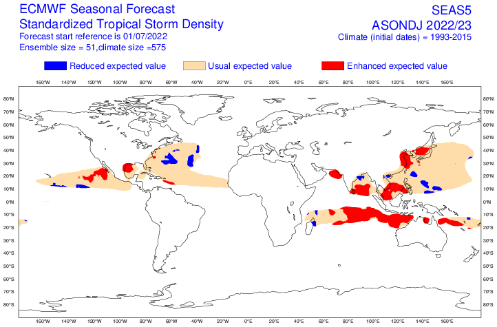
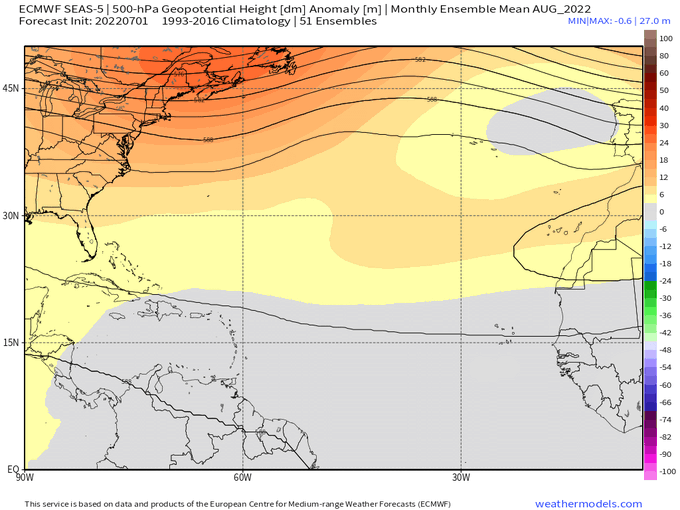
hurricane2025 wrote:What is your take on the new euro forecast with enhance in the western gulf?
wxman57 wrote:hurricane2025 wrote:What is your take on the new euro forecast with enhance in the western gulf?
I'm not sure what algorithm they use to produce such forecasts of enhanced or reduced activity, so it's hard to comment on that, specifically. However, The persistent ridge over the central U.S. and Texas which has led to an extended drought would suggest any enhancement would be for the NE Gulf and/or the southeast U.S. coast.

Users browsing this forum: Cpv17, Hurricaneman, Hybridstorm_November2001, WAcyclone and 40 guests


