

ATL: ALEX - Models
Moderator: S2k Moderators

Re: ATL: INVEST 91L - Models
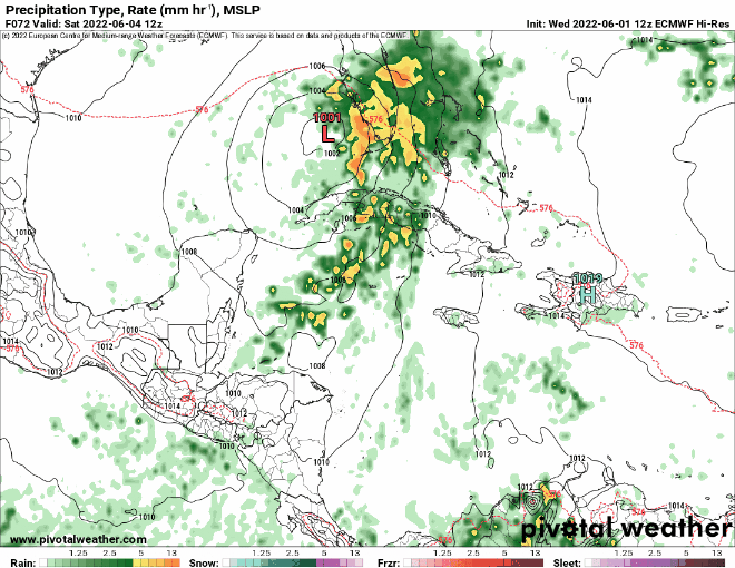
12z GFS is more organized than previous runs, 996 mbar just before landfall.

2 likes
-
ScottNAtlanta

- Category 5

- Posts: 2016
- Joined: Sat May 25, 2013 3:11 pm
- Location: Atlanta, GA
Re: ATL: INVEST 91L - Models
kevin wrote:12z GFS is more organized than previous runs, 996 mbar just before landfall.
https://i.imgur.com/hllXBcq.png
Is this the run from the new supercomputer test? I believe it is.
0 likes
The posts in this forum are NOT official forecast and should not be used as such. They are just the opinion of the poster and may or may not be backed by sound meteorological data. They are NOT endorsed by any professional institution or storm2k.org. For official information, please refer to the NHC and NWS products.
-
Jelmergraaff
- Tropical Storm

- Posts: 127
- Age: 21
- Joined: Fri Aug 27, 2021 1:00 pm
- Location: The Netherlands
Re: ATL: INVEST 91L - Models
ScottNAtlanta wrote:kevin wrote:12z GFS is more organized than previous runs, 996 mbar just before landfall.
https://i.imgur.com/hllXBcq.png
Is this the run from the new supercomputer test? I believe it is.
Would that actually matter in terms of model output? I guess the calculations being made (data-assimilation as well as the physical model itself) should be the same? Of course, when a new version of a model is used, the output will be different (i.e. GFSv15 and GFSv16), but - as far as I know - not when another computer does the calculations.
0 likes
20-year old meteorologist from The Netherlands. Interested in all fields of meteorology, including tropical systems like hurricanes.
-
tolakram
- Admin

- Posts: 19183
- Age: 61
- Joined: Sun Aug 27, 2006 8:23 pm
- Location: Florence, KY (name is Mark)
Re: ATL: INVEST 91L - Models
GFS trend

Euro trend

Who's catching up?
Euro trend
Who's catching up?
3 likes
M a r k
- - - - -
Join us in chat: Storm2K Chatroom Invite. Android and IOS apps also available.
The posts in this forum are NOT official forecasts and should not be used as such. Posts are NOT endorsed by any professional institution or STORM2K.org. For official information and forecasts, please refer to NHC and NWS products.
-
skyline385
- Category 5
- Posts: 2604
- Age: 33
- Joined: Wed Aug 26, 2020 11:15 pm
- Location: Houston TX
Re: ATL: INVEST 91L - Models
Maybe the 12Z GFS actually caught this eastwards movement away from Yucatan
2 likes
Re: ATL: INVEST 91L - Models
18z GFS shows much more rapid organization with a closed 997 mbar low only 8 - 9 hours from now. By comparison, it took the 12z run ~30 hours for the storm to reach such a state. Goes to show just how uncertain the situation is. If this run verifies, tomorrow's first recon (which arrives at 18z) might find a TS.

0 likes
-
skyline385
- Category 5
- Posts: 2604
- Age: 33
- Joined: Wed Aug 26, 2020 11:15 pm
- Location: Houston TX
Re: ATL: INVEST 91L - Models
18Z GFS seems to have initialized correctly looking at the current state of the system

1 likes
Re: ATL: INVEST 91L - Models
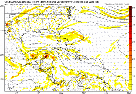
18z GFS is a bit further east than 12z and clips the westernmost point of Cuba, which causes the storm to weaken a bit (from 997mb to 1002mb) and lose some of its structure. However, it strenghtens again afterwards and has a secondary peak of 998 mbar & 40 kt. Anything post-Cuba is very uncertain though due to the possibility of a Cuban landfall. Tbh even the stuff before interaction with Cuba is up in the air. If anything, it's already a very interesting system to track.
1 likes
-
Blown Away

- S2K Supporter

- Posts: 9876
- Joined: Wed May 26, 2004 6:17 am
Re: ATL: INVEST 91L - Models
12z & 18z GFS now keeping a closed low on its approach to SFL. Now that we have a developing broad circulation and it appears to be setting up offshore, the next few model runs should confirm a sheared blob or maybe a more modest TS moving towards SFL.
0 likes
Hurricane Eye Experience: David 79, Irene 99, Frances 04, Jeanne 04, Wilma 05... EYE COMING MY WAY IN 2024…
Hurricane Brush Experience: Andrew 92, Erin 95, Floyd 99, Matthew 16, Irma 17, Ian 22, Nicole 22…
Hurricane Brush Experience: Andrew 92, Erin 95, Floyd 99, Matthew 16, Irma 17, Ian 22, Nicole 22…

Re: ATL: INVEST 91L - Models
kevin wrote:18z GFS is a bit further east than 12z and clips the westernmost point of Cuba, which causes the storm to weaken a bit (from 997mb to 1002mb) and lose some of its structure. However, it strenghtens again afterwards and has a secondary peak of 998 mbar & 40 kt. Anything post-Cuba is very uncertain though due to the possibility of a Cuban landfall. Tbh even the stuff before interaction with Cuba is up in the air. If anything, it's already a very interesting system to track.
https://imgur.com/KJvpWgY
I think the Western tip of Cuba is very flat and does little to disrupt a circulation.
0 likes
Personal Forecast Disclaimer:
My posts are just my opinion and are most likely not backed by sound meteorological data. They are NOT endorsed by any professional institution or storm2k.org. For official information, please refer to the NHC and NWS products.
Bottom line is that I am just expressing my opinion!!!
My posts are just my opinion and are most likely not backed by sound meteorological data. They are NOT endorsed by any professional institution or storm2k.org. For official information, please refer to the NHC and NWS products.
Bottom line is that I am just expressing my opinion!!!
-
cycloneye

- Admin
- Posts: 139710
- Age: 67
- Joined: Thu Oct 10, 2002 10:54 am
- Location: San Juan, Puerto Rico
Re: ATL: INVEST 91L - Models
0 likes
Visit the Caribbean-Central America Weather Thread where you can find at first post web cams,radars
and observations from Caribbean basin members Click Here
and observations from Caribbean basin members Click Here
-
cycloneye
- Admin
- Posts: 139710
- Age: 67
- Joined: Thu Oct 10, 2002 10:54 am
- Location: San Juan, Puerto Rico
Re: ATL: INVEST 91L - Models
Yes there is Adrian. 


2 likes
Visit the Caribbean-Central America Weather Thread where you can find at first post web cams,radars
and observations from Caribbean basin members Click Here
and observations from Caribbean basin members Click Here
-
skyline385
- Category 5
- Posts: 2604
- Age: 33
- Joined: Wed Aug 26, 2020 11:15 pm
- Location: Houston TX
-
SFLcane

- S2K Supporter
- Posts: 9627
- Age: 46
- Joined: Sat Jun 05, 2010 1:44 pm
- Location: Lake Worth Florida
Re: ATL: INVEST 91L - Models
skyline385 wrote:That HWFI intensity guidance, 0Z HWRF gonna be interesting
60 mph TS.
1 likes
-
Ian2401
- Category 1

- Posts: 284
- Joined: Thu Sep 14, 2017 5:55 pm
- Location: Tallahassee, Florida
- Contact:
Re: ATL: INVEST 91L - Models
When will we get our first HWRF runs for 91L?
0 likes
B.S. Meteorology from Florida State '24 // Current M.S. Meteorology student at Florida State
Research Interests: Rapid Intensification, TC Climatology, TC Modeling
Consult the NHC for official information
Research Interests: Rapid Intensification, TC Climatology, TC Modeling
Consult the NHC for official information
-
skyline385
- Category 5
- Posts: 2604
- Age: 33
- Joined: Wed Aug 26, 2020 11:15 pm
- Location: Houston TX
Re: RE: Re: ATL: INVEST 91L - Models
Ian2401 wrote:When will we get our first HWRF runs for 91L?
Should be tonight
0 likes
-
hurricane2025
- Tropical Storm
- Posts: 163
- Joined: Thu Apr 08, 2021 10:36 am
Who is online
Users browsing this forum: No registered users and 1 guest