
EPAC: BUD - Post-Tropical
Moderator: S2k Moderators
Re: EPAC: BUD - Hurricane
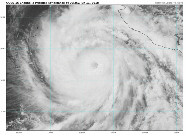
Last full visibles of the day
4 likes
The above post and any post by Ntxw is NOT an official forecast and should not be used as such. It is just the opinion of the poster and may or may not be backed by sound meteorological data. It is NOT endorsed by any professional institution including Storm2k. For official information, please refer to NWS products.
Help support Storm2K!


Re: EPAC: BUD - Hurricane
Looks really solid to me. Ragged eye is all but gone at this point
4 likes
Very useful information on the Dvorak Technique --
https://severe.worldweather.wmo.int/TCF ... kBeven.pdf
https://severe.worldweather.wmo.int/TCF ... kBeven.pdf
-
cycloneye

- Admin

- Posts: 139334
- Age: 67
- Joined: Thu Oct 10, 2002 10:54 am
- Location: San Juan, Puerto Rico
Re: EPAC: BUD - Hurricane
EP, 03, 2018061200, , BEST, 0, 174N, 1073W, 110, 951, HU
0 likes
Visit the Caribbean-Central America Weather Thread where you can find at first post web cams,radars
and observations from Caribbean basin members Click Here
and observations from Caribbean basin members Click Here
-
StormChaser75

- Tropical Depression

- Posts: 92
- Age: 22
- Joined: Sat Feb 06, 2016 4:23 pm
- Location: Corpus Christi TX
- Contact:

-
cycloneye
- Admin
- Posts: 139334
- Age: 67
- Joined: Thu Oct 10, 2002 10:54 am
- Location: San Juan, Puerto Rico
Re: EPAC: BUD - Hurricane
Hurricane Bud Discussion Number 10
NWS National Hurricane Center Miami FL EP032018
900 PM MDT Mon Jun 11 2018
Bud has been sending mixed signals this evening regarding its
intensity. On one hand, the eye has been warming and become more
distinct in infrared satellite imagery. On the other hand, the
central dense overcast has been shrinking, and temperatures of the
convective cloud tops have been warming as well. Subjective Dvorak
estimates from TAFB and SAB are T5.5/102 kt while the objective ADT
peaked at 6.5/127 kt. The initial intensity is raised to 110 kt as
a compromise of these values.
Bud appears to be going through a trochoidal oscillation, but the
longer-term motion estimate is northwestward, or 315/6 kt. The
hurricane is moving between a large mid-level high centered near
the U.S./Mexico border and Post-Tropical Cyclone Aletta, but with
the ridge directly to its north, Bud's forward speed is expected to
slow down to 4-5 kt for the next 48 hours. After that time, a
developing mid- to upper-level trough off the California coast will
cause Bud to turn northward and accelerate across the Baja
California Peninsula. The track models are tightly clustered, with
the only subtle outlier being the ECMWF, which is a little slower
and to the west of the other models. The NHC forecast is closest
to the TVCX multi-model consensus and not too different from the
previous forecast.
Since vertical shear is forecast to remain low for the next 3 days
or so and there is plenty of atmospheric moisture, the biggest
limiting factor on intensification appears to be low oceanic heat
content. Bud has reached an area where waters of 26C or warmer
only extend 20 meters or less below the ocean surface. Upwelling
of colder water is likely due to the hurricane's expected slow
motion, and the colder water will likely induce a rather quick
weakening trend. The HCCA and Florida State Superensemble show the
most dramatic drop-off in winds, while the SHIPS model maintains
Bud's intensity for another 24 hours or so before showing much
weakening. The NHC intensity forecast is between these two
scenarios, with Bud expected to fall below hurricane intensity near
the 48-hour mark (late Wednesday). Continued weakening is expected
as Bud approaches and moves across the southern Baja California
Peninsula, and the cyclone is likely to be a remnant low over
the Mexican state of Sonora by day 5.
FORECAST POSITIONS AND MAX WINDS
INIT 12/0300Z 17.6N 107.6W 110 KT 125 MPH
12H 12/1200Z 18.1N 107.9W 105 KT 120 MPH
24H 13/0000Z 18.8N 108.3W 90 KT 105 MPH
36H 13/1200Z 19.4N 108.7W 75 KT 85 MPH
48H 14/0000Z 20.2N 109.2W 65 KT 75 MPH
72H 15/0000Z 22.4N 110.3W 45 KT 50 MPH
96H 16/0000Z 25.5N 111.0W 30 KT 35 MPH
120H 17/0000Z 30.0N 110.5W 20 KT 25 MPH...POST-TROP/INLAND
$$
Forecaster Berg
0 likes
Visit the Caribbean-Central America Weather Thread where you can find at first post web cams,radars
and observations from Caribbean basin members Click Here
and observations from Caribbean basin members Click Here
-
hurricanes1234
- Category 5

- Posts: 2903
- Joined: Sat Jul 28, 2012 6:19 pm
- Location: Trinidad and Tobago
Re: EPAC: BUD - Hurricane
Just below category 4 strength.
0 likes
PLEASE NOTE: With the exception of information from weather agencies that I may copy and paste here, my posts will NEVER be official, since I am NOT a meteorologist. They are solely my amateur opinion, and may or may not be accurate. Therefore, please DO NOT use them as official details, particularly when making important decisions. Thank you.
-
galaxy401

- Category 5
- Posts: 2299
- Age: 29
- Joined: Sat Aug 25, 2012 9:04 pm
- Location: Casa Grande, Arizona
Re: EPAC: BUD - Hurricane
Kingarabian wrote:Let's see how much the numbers go up if/when the eye completely clears out. Because SAB is lagging behind the rest, constraints may limit its estimates. NHC will likely need to rely on ADT and TAFB if we want to see a cat.5.
Cat 5 is very unlikely with this storm. A clear eye isn't the only thing required, you also need a solid ring of very cold cloud tops around the eyewall.
0 likes
Got my eyes on moving right into Hurricane Alley: Florida.
-
Kingarabian

- S2K Supporter

- Posts: 15451
- Joined: Sat Aug 08, 2009 3:06 am
- Location: Honolulu, Hawaii
Re: EPAC: BUD - Hurricane
galaxy401 wrote:Kingarabian wrote:Let's see how much the numbers go up if/when the eye completely clears out. Because SAB is lagging behind the rest, constraints may limit its estimates. NHC will likely need to rely on ADT and TAFB if we want to see a cat.5.
Cat 5 is very unlikely with this storm. A clear eye isn't the only thing required, you also need a solid ring of very cold cloud tops around the eyewall.
That's what it had prior to the eye warming. Clouds were cold enough that if the eye cleared out we would've seen raw 7.0s. Now we have a warm eye but no cold cloud tops. Like the NHC said, lots of mixed signals with Bud.
2 likes
RIP Kobe Bryant
-
hurricanes1234
- Category 5
- Posts: 2903
- Joined: Sat Jul 28, 2012 6:19 pm
- Location: Trinidad and Tobago
Re: EPAC: BUD - Hurricane
Looks like my initial prediction of 115 knots may not be too far off.
I agree it's highly unlikely we'll see a category 5, but a minimal category 4 still seems somewhat possible.
I agree it's highly unlikely we'll see a category 5, but a minimal category 4 still seems somewhat possible.
0 likes
PLEASE NOTE: With the exception of information from weather agencies that I may copy and paste here, my posts will NEVER be official, since I am NOT a meteorologist. They are solely my amateur opinion, and may or may not be accurate. Therefore, please DO NOT use them as official details, particularly when making important decisions. Thank you.
-
StormChaser75
- Tropical Depression
- Posts: 92
- Age: 22
- Joined: Sat Feb 06, 2016 4:23 pm
- Location: Corpus Christi TX
- Contact:


-
Kingarabian
- S2K Supporter
- Posts: 15451
- Joined: Sat Aug 08, 2009 3:06 am
- Location: Honolulu, Hawaii

-
Yellow Evan

- Professional-Met

- Posts: 15956
- Age: 25
- Joined: Fri Jul 15, 2011 12:48 pm
- Location: Henderson, Nevada/Honolulu, HI
- Contact:
Re: EPAC: BUD - Hurricane
TXPZ23 KNES 120624
TCSENP
A. 03E (BUD)
B. 12/0600Z
C. 17.8N
D. 107.9W
E. ONE/GOES-W
F. T5.5/5.5/D1.0/24HRS
G. IR/EIR/SWIR
H. REMARKS...EYE PATTERN WITH A WMG (+11C) EYE SURROUNDED
BY B AND EMBEDDED IN MG FOR A DT=5.5 INCLUDING A +1.0 EYE
ADJUSTMENT. MET=5.0. PT=5.5. FT IS BASED ON DT. EMBEDDED IN LG .35 WAS
SHORT OF 0.4 DEGREE DVORAK REQUIREMENT.
I. ADDL POSITIONS
NIL
...LEE
Embedded in LG but MG SAB...
0 likes
-
Yellow Evan
- Professional-Met
- Posts: 15956
- Age: 25
- Joined: Fri Jul 15, 2011 12:48 pm
- Location: Henderson, Nevada/Honolulu, HI
- Contact:
Re: EPAC: BUD - Hurricane
EP, 03, 2018061206, , BEST, 0, 178N, 1079W, 115, 948, HU, 34, NEQ, 80, 100, 70, 70, 1008, 180, 15, 0, 0, E, 0, , 0, 0, BUD, D,
1 likes

Re: EPAC: BUD - Hurricane
I'd go ahead and say Bud is a Category 5 now. Too bad looks are everything. Even Hurricane Irma last year didn't sport a solid CDO and deep convection at peak and led all dvorak numbers by a mile. Recon?
2 likes
Remember, all of my post aren't official. For official warnings and discussions, Please refer to your local NWS products...
NWS for the Western Pacific
https://www.weather.gov/gum/
NWS for the Western Pacific
https://www.weather.gov/gum/
-
cycloneye
- Admin
- Posts: 139334
- Age: 67
- Joined: Thu Oct 10, 2002 10:54 am
- Location: San Juan, Puerto Rico
Re: EPAC: BUD - Hurricane
Hurricane Bud Discussion Number 11
NWS National Hurricane Center Miami FL EP032018
300 AM MDT Tue Jun 12 2018
Bud has been maintaining a well-defined eye for the past several
hours but recent satellite images suggest some loss of definition.
The current intensity is set to 115 kt in agreement with a Dvorak
current intensity estimate from TAFB. Even though Bud is currently
a powerful hurricane, it is going to pass over ocean waters of
progressively decreasing heat content and lower SSTs. Therefore,
weakening is likely. Gradual weakening should commence later
today, but by Wednesday the rate of weakening should increase as
the ocean becomes significantly less conducive. The official
intensity forecast is close to the multi-model consensus guidance
IVCN, however the corrected/smart consensus models HCCA and the
Florida State University Superensemble show a more rapid decline in
intensity than shown here. Bud is likely to degenerate into a
remnant low by the time it reaches mainland Mexico.
Bud's movement has continued to exhibit a trochoidal oscillation,
which is typical of major hurricanes. Smoothing through these
trochoidal wobbles gives an estimated motion that is the same as in
the previous advisory, or 315/6 kt. The track forecast reasoning is
essentially unchanged. Bud is moving between a large mid-level
anticyclone centered near the United States/Mexico border and the
circulation of Post-Tropical Cyclone Aletta. Over the next day or
so, increased ridging to the north of Bud should result in a
slowing of the forward motion of the tropical cyclone. Later, a
trough off the southern California and northern Baja California
Peninsula coasts should cause Bud to turn to the north with some
increase in forward speed. The official track forecast is close to
the previous one, and in good agreement with the latest multi-model
consensus.
FORECAST POSITIONS AND MAX WINDS
INIT 12/0900Z 18.1N 108.2W 115 KT 130 MPH
12H 12/1800Z 18.5N 108.4W 105 KT 120 MPH
24H 13/0600Z 19.2N 108.8W 90 KT 105 MPH
36H 13/1800Z 19.9N 109.1W 80 KT 90 MPH
48H 14/0600Z 20.9N 109.5W 65 KT 75 MPH
72H 15/0600Z 23.4N 110.5W 45 KT 50 MPH
96H 16/0600Z 26.7N 111.0W 30 KT 35 MPH
120H 17/0600Z 31.0N 111.0W 20 KT 25 MPH...POST-TROP/INLAND
$$
Forecaster Pasch
0 likes
Visit the Caribbean-Central America Weather Thread where you can find at first post web cams,radars
and observations from Caribbean basin members Click Here
and observations from Caribbean basin members Click Here
-
hurricanes1234
- Category 5
- Posts: 2903
- Joined: Sat Jul 28, 2012 6:19 pm
- Location: Trinidad and Tobago
Re: EPAC: BUD - Hurricane: Up to Category 4
Two category 4's is really impressive for the first two weeks in June.
3 likes
PLEASE NOTE: With the exception of information from weather agencies that I may copy and paste here, my posts will NEVER be official, since I am NOT a meteorologist. They are solely my amateur opinion, and may or may not be accurate. Therefore, please DO NOT use them as official details, particularly when making important decisions. Thank you.
Re: EPAC: BUD - Hurricane
galaxy401 wrote:Kingarabian wrote:Let's see how much the numbers go up if/when the eye completely clears out. Because SAB is lagging behind the rest, constraints may limit its estimates. NHC will likely need to rely on ADT and TAFB if we want to see a cat.5.
Cat 5 is very unlikely with this storm. A clear eye isn't the only thing required, you also need a solid ring of very cold cloud tops around the eyewall.
Ask that to Irma.
4 likes
Remember, all of my post aren't official. For official warnings and discussions, Please refer to your local NWS products...
NWS for the Western Pacific
https://www.weather.gov/gum/
NWS for the Western Pacific
https://www.weather.gov/gum/
-
StruThiO

- Category 3

- Posts: 821
- Age: 24
- Joined: Fri Sep 15, 2017 5:51 am
- Location: Currently Portland, OR. Raised in Jax, FL.
Re: EPAC: BUD - Hurricane: Up to Category 4
Yeah Irma had pretty weak cloud tops given its intensity, different basin different profile however.
Edit: also who doesn't want recon in Pacific systems? Most of the strongest systems ever occur in the Pacific, and i'm sure all of us want those direct observations via plane. It really is a shame.. Anyways staying on topic it does seem like bud is starting to weaken, which makes sense given SSTs
Edit: also who doesn't want recon in Pacific systems? Most of the strongest systems ever occur in the Pacific, and i'm sure all of us want those direct observations via plane. It really is a shame.. Anyways staying on topic it does seem like bud is starting to weaken, which makes sense given SSTs
1 likes
Re: EPAC: BUD - Hurricane: Up to Category 4
Early day visible. He is weakening so downward trend from here

0 likes
The above post and any post by Ntxw is NOT an official forecast and should not be used as such. It is just the opinion of the poster and may or may not be backed by sound meteorological data. It is NOT endorsed by any professional institution including Storm2k. For official information, please refer to NWS products.
Help support Storm2K!
Help support Storm2K!
-
supercane4867
- Category 5
- Posts: 4966
- Joined: Wed Nov 14, 2012 10:43 am
Re: EPAC: BUD - Hurricane: Up to Category 4
euro6208 wrote:galaxy401 wrote:Kingarabian wrote:Let's see how much the numbers go up if/when the eye completely clears out. Because SAB is lagging behind the rest, constraints may limit its estimates. NHC will likely need to rely on ADT and TAFB if we want to see a cat.5.
Cat 5 is very unlikely with this storm. A clear eye isn't the only thing required, you also need a solid ring of very cold cloud tops around the eyewall.
Ask that to Irma.
Bud is a far cry from CAT5.
Irma intensified to 160KT during daytime is why it had warmer CDO temps. However, both visible and microwave imagery at the time indicates extreme intensity. The IR presentation quickly caught up in the evening when its pressure continued to fall. Also there was a lack of enrichment from monsoon trough for Irma, along with a generally dry environment in the outer Atlantic made it much harder to produce very cold cloud tops.

Again, this is not a CAT5 by any measure

6 likes
Who is online
Users browsing this forum: No registered users and 4 guests