https://twitter.com/MJVentrice/status/1129014286129537025
2019 Indicators: SST'S / Sal / MSLP / Steering / Shear / Instability (See updated graphics at first post)
Moderator: S2k Moderators
Forum rules

The posts in this forum are NOT official forecasts and should not be used as such. They are just the opinion of the poster and may or may not be backed by sound meteorological data. They are NOT endorsed by any professional institution or STORM2K. For official information, please refer to products from the National Hurricane Center and National Weather Service.
-
cycloneye

- Admin

- Posts: 139517
- Age: 67
- Joined: Thu Oct 10, 2002 10:54 am
- Location: San Juan, Puerto Rico
Re: 2019 Indicators: SST'S / Sal / MSLP / Steering / Shear / Instability (See updated graphics at first post)
2 likes
Visit the Caribbean-Central America Weather Thread where you can find at first post web cams,radars
and observations from Caribbean basin members Click Here
and observations from Caribbean basin members Click Here
-
cycloneye
- Admin
- Posts: 139517
- Age: 67
- Joined: Thu Oct 10, 2002 10:54 am
- Location: San Juan, Puerto Rico
Re: 2019 Indicators: SST'S / Sal / MSLP / Steering / Shear / Instability (See updated graphics at first post)
1 likes
Visit the Caribbean-Central America Weather Thread where you can find at first post web cams,radars
and observations from Caribbean basin members Click Here
and observations from Caribbean basin members Click Here
-
cycloneye
- Admin
- Posts: 139517
- Age: 67
- Joined: Thu Oct 10, 2002 10:54 am
- Location: San Juan, Puerto Rico
Re: 2019 Indicators: SST'S / Sal / MSLP / Steering / Shear / Instability (See updated graphics at first post)
3 likes
Visit the Caribbean-Central America Weather Thread where you can find at first post web cams,radars
and observations from Caribbean basin members Click Here
and observations from Caribbean basin members Click Here
-
TheStormExpert

- Category 5

- Posts: 8487
- Age: 30
- Joined: Wed Feb 16, 2011 5:38 pm
- Location: Palm Beach Gardens, FL
Re: 2019 Indicators: SST'S / Sal / MSLP / Steering / Shear / Instability (See updated graphics at first post)
One thing that I've noticed is the that the Bermuda High has been virtually non-existent so far this year minus a few times.
1 likes
The following post is NOT an official forecast and should not be used as such. It is just the opinion of the poster and may or may not be backed by sound meteorological data. It is NOT endorsed by storm2k.org.
-
Kingarabian

- S2K Supporter

- Posts: 15456
- Joined: Sat Aug 08, 2009 3:06 am
- Location: Honolulu, Hawaii
Re: 2019 Indicators: SST'S / Sal / MSLP / Steering / Shear / Instability (See updated graphics at first post)
TheStormExpert wrote:One thing that I've noticed is the that the Bermuda High has been virtually non-existent so far this year minus a few times.
Is this due to a -NAO?
2 likes
RIP Kobe Bryant
-
NotSparta

- Professional-Met

- Posts: 1658
- Age: 22
- Joined: Fri Aug 18, 2017 8:24 am
- Location: Naples, FL
- Contact:
Re: 2019 Indicators: SST'S / Sal / MSLP / Steering / Shear / Instability (See updated graphics at first post)
Kingarabian wrote:TheStormExpert wrote:One thing that I've noticed is the that the Bermuda High has been virtually non-existent so far this year minus a few times.
Is this due to a -NAO?
Yes, especially this month
1 likes
This post was probably an opinion of mine, and in no way is official. Please refer to http://www.hurricanes.gov for official tropical analysis and advisories.
My website, with lots of tropical wx graphics, including satellite and recon: http://cyclonicwx.com
My website, with lots of tropical wx graphics, including satellite and recon: http://cyclonicwx.com
-
Shell Mound
- Category 5
- Posts: 2434
- Age: 31
- Joined: Thu Sep 07, 2017 3:39 pm
- Location: St. Petersburg, FL → Scandinavia
Re: 2019 Indicators: SST'S / Sal / MSLP / Steering / Shear / Instability (See updated graphics at first post)
With an overall warmer AMO than at this time in 2018, along with a struggling or decaying El Niño, a very active African monsoon (hence above-average rainfall over the Sahel), a weaker +PDO/+PMM signal, and a persistent –NAO, there is an increasing possibility that 2019 may be at least as active as last year, if not slightly more favourable. Even if El Niño were to survive or reemerge, it might be weaker and hence farther west, à la Modoki, which would reduce the impact of shear over the tropical Atlantic, especially over the MDR, to eastward of the Caribbean. Maybe a year like 2004 is possible.
4 likes
CVW / MiamiensisWx / Shell Mound
The posts in this forum are NOT official forecasts and should not be used as such. They are just the opinion of the poster and may or may not be backed by sound meteorological data. They are NOT endorsed by any professional institution or STORM2K. For official information, please refer to products from the NHC and NWS.
-
TheStormExpert
- Category 5
- Posts: 8487
- Age: 30
- Joined: Wed Feb 16, 2011 5:38 pm
- Location: Palm Beach Gardens, FL
Re: 2019 Indicators: SST'S / Sal / MSLP / Steering / Shear / Instability (See updated graphics at first post)
Shell Mound wrote:With an overall warmer AMO than at this time in 2018, along with a struggling or decaying El Niño, a very active African monsoon (hence above-average rainfall over the Sahel), a weaker +PDO/+PMM signal, and a persistent –NAO, there is an increasing possibility that 2019 may be at least as active as last year, if not slightly more favourable. Even if El Niño were to survive or reemerge, it might be weaker and hence farther west, à la Modoki, which would reduce the impact of shear over the tropical Atlantic, especially over the MDR, to eastward of the Caribbean. Maybe a year like 2004 is possible.
Please don’t say 2004!
1 likes
The following post is NOT an official forecast and should not be used as such. It is just the opinion of the poster and may or may not be backed by sound meteorological data. It is NOT endorsed by storm2k.org.

Re: 2019 Indicators: SST'S / Sal / MSLP / Steering / Shear / Instability (See updated graphics at first post)
TheStormExpert wrote:One thing that I've noticed is the that the Bermuda High has been virtually non-existent so far this year minus a few times.
Isn't this the usual pattern for the Bermuda High for this time of the season/pre-season?
0 likes
Personal Forecast Disclaimer:
The posts in this forum are NOT official forecast and should not be used as such. They are just the opinion of the poster and may or may not be backed by sound meteorological data. They are NOT endorsed by any professional institution or storm2k.org. For official information, please refer to the NHC and NWS products.
The posts in this forum are NOT official forecast and should not be used as such. They are just the opinion of the poster and may or may not be backed by sound meteorological data. They are NOT endorsed by any professional institution or storm2k.org. For official information, please refer to the NHC and NWS products.


Re: 2019 Indicators: SST'S / Sal / MSLP / Steering / Shear / Instability (See updated graphics at first post)
0 likes
Personal Forecast Disclaimer:
The posts in this forum are NOT official forecast and should not be used as such. They are just the opinion of the poster and may or may not be backed by sound meteorological data. They are NOT endorsed by any professional institution or storm2k.org. For official information, please refer to the NHC and NWS products.
The posts in this forum are NOT official forecast and should not be used as such. They are just the opinion of the poster and may or may not be backed by sound meteorological data. They are NOT endorsed by any professional institution or storm2k.org. For official information, please refer to the NHC and NWS products.
-
Hurricaneman

- Category 5
- Posts: 7284
- Age: 43
- Joined: Tue Aug 31, 2004 3:24 pm
- Location: central florida
Re: 2019 Indicators: SST'S / Sal / MSLP / Steering / Shear / Instability (See updated graphics at first post)
The shear on the CFSV2 monthlies on the tropical tidbits site is actually quite concerning and seems to be setting up with not much in the MDR but similar to years like 2005 and 1985 where things were very favorable near land so if i’m making a new forecast a blend of 1969, 1985, 2005 and 1979 may be the better analogs with 2002 being right behind if somehow El Niño strengthens
4 likes
Re: 2019 Indicators: SST'S / Sal / MSLP / Steering / Shear / Instability (See updated graphics at first post)
Hurricaneman wrote:The shear on the CFSV2 monthlies on the tropical tidbits site is actually quite concerning and seems to be setting up with not much in the MDR but similar to years like 2005 and 1985 where things were very favorable near land so if i’m making a new forecast a blend of 1969, 1985, 2005 and 1979 may be the better analogs with 2002 being right behind if somehow El Niño strengthens
Taking this one step further, implications for a significantly enhanced landfall risk from New England southward toward the Mid-Atlantic States between August and October might exist if the CFSV2 500mb forecast anomaly charts were to verify. Anomalous W. Atlantic 500mb heights are generally forecast to be slightly high, with greatest anomalous heights anchored over the Canadian Maritimes during this period. Such would imply a far West Atlantic blocking pattern shunting potential storms already west of 60-70 longitude, to generally track further northwest to westward. Depending on strength, orientation, and placement of such blocking the general result would imply a greater potential for tropical cyclones north of 20N and West of 70W to be blocked from turning pole-ward or re-curving out to sea such as the majority of historic Atlantic Storm tracks have in the past.
None of the above suggests negating any risk to other regions (such as the West or N. Gulf, Florida, Bahamas, the Caribbean, or Central America). If this season produces a reduction of MDR activity though, in tandem with a greater concentration of tropical storms developing near Florida, the Bahamas or the Greater Antilles, it stands to reason that those storms having the greatest potential for strengthening would be those with relative longer storm tracks.... especially if those tracks traversed over anomalously warm SST's in the process. If the analog years such as Hurricaneman suggests are a general indication of potential activity and where basin activity may be focused, coupled with longer term SST forecast suggesting broadly warmer then normal SST's off the entire U.S. Seaboard & S.E. Canada (CFSv2 Sea Surface Temp Anomaly-Tropical Tidbits), then this summer/fall may prove to be an eventful one for the E. CONUS.
2 likes
Personal Forecast Disclaimer:
The posts in this forum are NOT official forecast and should not be used as such. They are just the opinion of the poster and may or may not be backed by sound meteorological data. They are NOT endorsed by any professional institution or storm2k.org. For official information, please refer to the NHC and NWS products.
The posts in this forum are NOT official forecast and should not be used as such. They are just the opinion of the poster and may or may not be backed by sound meteorological data. They are NOT endorsed by any professional institution or storm2k.org. For official information, please refer to the NHC and NWS products.
-
Shell Mound
- Category 5
- Posts: 2434
- Age: 31
- Joined: Thu Sep 07, 2017 3:39 pm
- Location: St. Petersburg, FL → Scandinavia
Re: 2019 Indicators: SST'S / Sal / MSLP / Steering / Shear / Instability (See updated graphics at first post)
Hurricaneman wrote:The shear on the CFSV2 monthlies on the tropical tidbits site is actually quite concerning and seems to be setting up with not much in the MDR but similar to years like 2005 and 1985 where things were very favorable near land so if i’m making a new forecast a blend of 1969, 1985, 2005 and 1979 may be the better analogs with 2002 being right behind if somehow El Niño strengthens
Actually, based on what I see, the latest trimonthly CFSv2 shows a robust African monsoon in JJA/ASO, with well-above-average precipitation in the east-central MDR. I would keep in mind that previous "dry" runs of the CFSv2 were assuming a persistent El Niño, which now seems increasingly unlikely. The very latest CFSv2 runs, when adjusted for climatology, are now showing dead neutral ENSO in JJA/ASO, with a Modoki-like SST configuration in place over the tropical Pacific: a cool NINO 1+2 and a warm NINO 3+4. This type of gradient would tend to reduce vertical wind shear over the MDR and allow more upward motion over the tropical Atlantic relative to that in a typical El Niño. Furthermore, the latest CFSv2 runs now show a significantly warmer, solid +AMO in place for the peak of the 2019 Atlantic hurricane season compared to previous runs. Notably, the CFSv2 has been rather persistent in suggesting a strong Bermuda High that would tend to concentrate threats from the Florida peninsula to the Carolinas, similar to what we observed in 2004, another year that featured neutral/warm neutral ENSO and a +AMO during peak season. The projected SST configuration in the Pacific, barring other factors, would tend to promote a west-based subtropical ridge in JJA/ASO of 2019. So not only could we see a more active season than many people originally anticipated, but also one that produces a fair proportion of threats.
6 likes
CVW / MiamiensisWx / Shell Mound
The posts in this forum are NOT official forecasts and should not be used as such. They are just the opinion of the poster and may or may not be backed by sound meteorological data. They are NOT endorsed by any professional institution or STORM2K. For official information, please refer to products from the NHC and NWS.
-
SFLcane

- S2K Supporter
- Posts: 9622
- Age: 46
- Joined: Sat Jun 05, 2010 1:44 pm
- Location: Lake Worth Florida
Re: 2019 Indicators: SST'S / Sal / MSLP / Steering / Shear / Instability (See updated graphics at first post)
One of the more aggressive CFS looks I have ever seen 
Last edited by SFLcane on Wed May 22, 2019 7:19 am, edited 1 time in total.
0 likes
-
NotSparta
- Professional-Met
- Posts: 1658
- Age: 22
- Joined: Fri Aug 18, 2017 8:24 am
- Location: Naples, FL
- Contact:
Re: 2019 Indicators: SST'S / Sal / MSLP / Steering / Shear / Instability (See updated graphics at first post)
Shell Mound wrote:Hurricaneman wrote:The shear on the CFSV2 monthlies on the tropical tidbits site is actually quite concerning and seems to be setting up with not much in the MDR but similar to years like 2005 and 1985 where things were very favorable near land so if i’m making a new forecast a blend of 1969, 1985, 2005 and 1979 may be the better analogs with 2002 being right behind if somehow El Niño strengthens
Actually, based on what I see, the latest trimonthly CFSv2 shows a robust African monsoon in JJA/ASO, with well-above-average precipitation in the east-central MDR. I would keep in mind that previous "dry" runs of the CFSv2 were assuming a persistent El Niño, which now seems increasingly unlikely. The very latest CFSv2 runs, when adjusted for climatology, are now showing dead neutral ENSO in JJA/ASO, with a Modoki-like SST configuration in place over the tropical Pacific: a cool NINO 1+2 and a warm NINO 3+4. This type of gradient would tend to reduce vertical wind shear over the MDR and allow more upward motion over the tropical Atlantic relative to that in a typical El Niño. Furthermore, the latest CFSv2 runs now show a significantly warmer, solid +AMO in place for the peak of the 2019 Atlantic hurricane season compared to previous runs. Notably, the CFSv2 has been rather persistent in suggesting a strong Bermuda High that would tend to concentrate threats from the Florida peninsula to the Carolinas, similar to what we observed in 2004, another year that featured neutral/warm neutral ENSO and a +AMO during peak season. The projected SST configuration in the Pacific, barring other factors, would tend to promote a west-based subtropical ridge in JJA/ASO of 2019. So not only could we see a more active season than many people originally anticipated, but also one that produces a fair proportion of threats.
Yeah, the CFS had a huge trend about a week ago. Went from high westerly shear in the MDR due to El Niño, to high easterly shear w/ neutral ENSO & a strong WAM/TEJ. Of course the forecasts aren't the best however
1 likes
This post was probably an opinion of mine, and in no way is official. Please refer to http://www.hurricanes.gov for official tropical analysis and advisories.
My website, with lots of tropical wx graphics, including satellite and recon: http://cyclonicwx.com
My website, with lots of tropical wx graphics, including satellite and recon: http://cyclonicwx.com
-
TheStormExpert
- Category 5
- Posts: 8487
- Age: 30
- Joined: Wed Feb 16, 2011 5:38 pm
- Location: Palm Beach Gardens, FL
Re: 2019 Indicators: SST'S / Sal / MSLP / Steering / Shear / Instability (See updated graphics at first post)
0 likes
The following post is NOT an official forecast and should not be used as such. It is just the opinion of the poster and may or may not be backed by sound meteorological data. It is NOT endorsed by storm2k.org.
-
AutoPenalti
- Category 5
- Posts: 3950
- Age: 27
- Joined: Mon Aug 17, 2015 4:16 pm
- Location: Ft. Lauderdale, Florida
Re: 2019 Indicators: SST'S / Sal / MSLP / Steering / Shear / Instability (See updated graphics at first post)
JJA

ASO

ASO
1 likes
The posts in this forum are NOT official forecasts and should not be used as such. They are just the opinion of the poster and may or may not be backed by sound meteorological data. They are NOT endorsed by any professional institution or STORM2K. For official information, please refer to products from the NHC and NWS.
Model Runs Cheat Sheet:
GFS (5:30 AM/PM, 11:30 AM/PM)
HWRF, GFDL, UKMET, NAVGEM (6:30-8:00 AM/PM, 12:30-2:00 AM/PM)
ECMWF (1:45 AM/PM)
TCVN is a weighted averaged
-
NotSparta
- Professional-Met
- Posts: 1658
- Age: 22
- Joined: Fri Aug 18, 2017 8:24 am
- Location: Naples, FL
- Contact:
Re: 2019 Indicators: SST'S / Sal / MSLP / Steering / Shear / Instability (See updated graphics at first post)
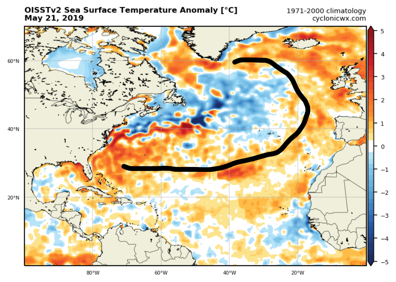
Today, I'm seeing a bit of a +AMO horseshoe, but nothing displaced so the warm waters that would be be in the MDR in a canonical +AMO are in the subtropics, but bleeds a bit into the MDR. Not too sure if this means much though
3 likes
This post was probably an opinion of mine, and in no way is official. Please refer to http://www.hurricanes.gov for official tropical analysis and advisories.
My website, with lots of tropical wx graphics, including satellite and recon: http://cyclonicwx.com
My website, with lots of tropical wx graphics, including satellite and recon: http://cyclonicwx.com
-
weathaguyry

- Category 5
- Posts: 1272
- Age: 20
- Joined: Wed Jun 15, 2016 5:16 am
- Location: Long Island, NY
Re: 2019 Indicators: SST'S / Sal / MSLP / Steering / Shear / Instability (See updated graphics at first post)
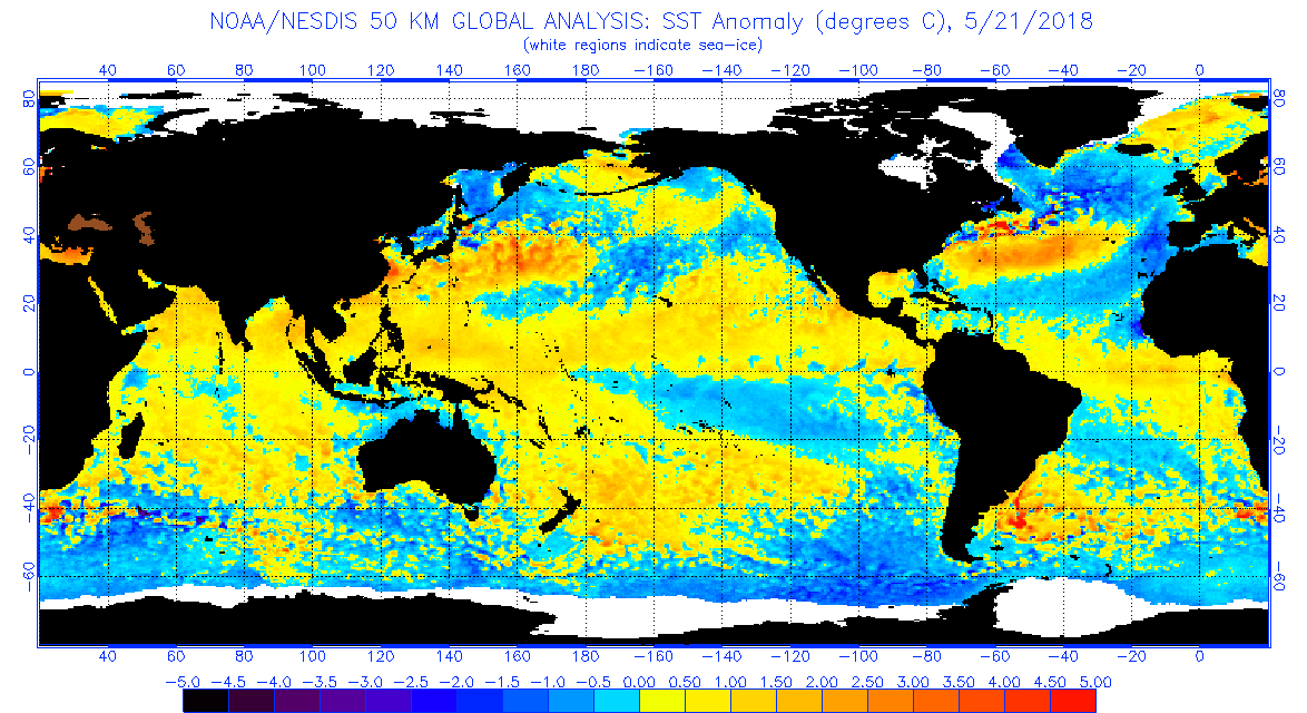
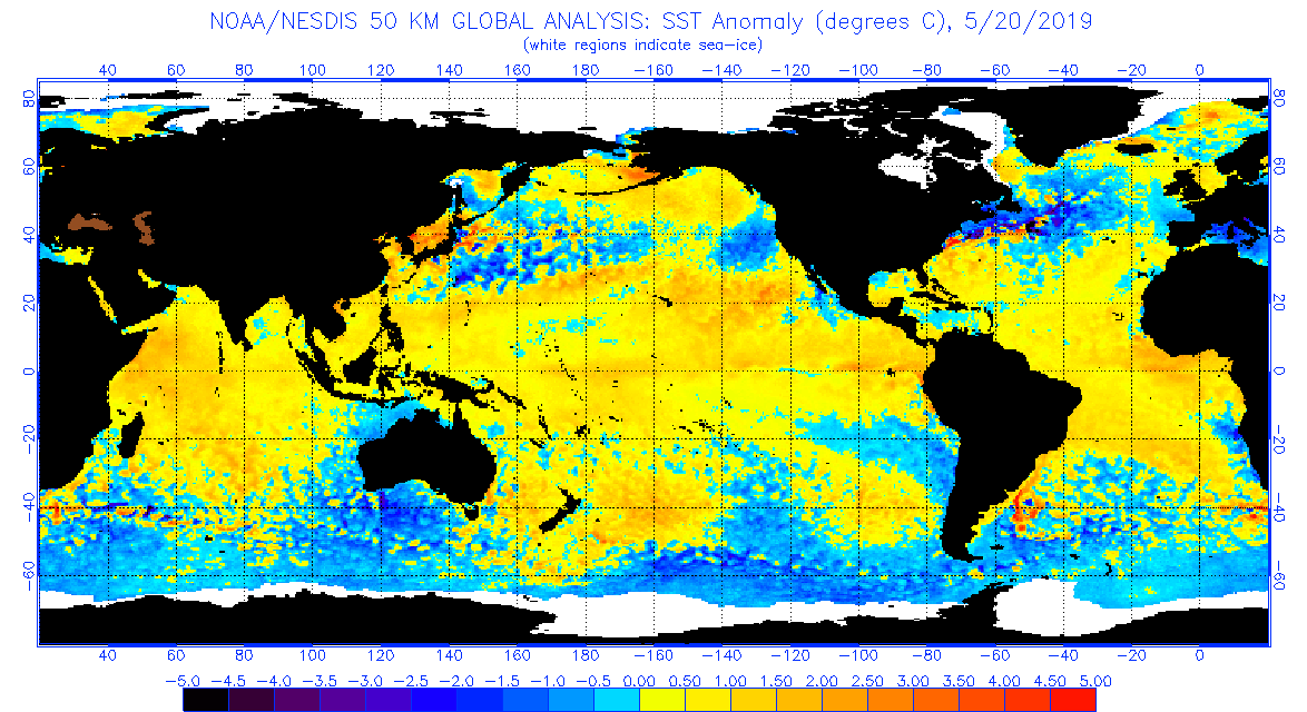
One thing that’s interesting is the remarkable difference in SST’s between last year and this year in the Atlantic. Assuming the El Niño remains neutral throughout the season like last year, this could end up being a pretty hefty season in numbers of storms with the warm subtropics AND quality of storms with a +AMO sort of look. However, it is May and a lot can change, but if the -NAO sticks around, the MDR will only get warmer as we approach hurricane season...
2018
2019
2018
2019
1 likes
My posts are only my opinions and NOT official forecasts. For official forecasts, consult the National Hurricane Center or the National Weather Service.
Irene 11', Sandy 12', Fay 20’, Isaias 20’, Elsa 21’, Henri 21’, Ida 21’
Irene 11', Sandy 12', Fay 20’, Isaias 20’, Elsa 21’, Henri 21’, Ida 21’
Who is online
Users browsing this forum: Cdenton12, Cpv17, Hurricaneman, saila and 24 guests