2021 Indicators: SST's / SAL / MSLP / Shear / Steering / Instability / Sat Images
Moderator: S2k Moderators
Forum rules

The posts in this forum are NOT official forecasts and should not be used as such. They are just the opinion of the poster and may or may not be backed by sound meteorological data. They are NOT endorsed by any professional institution or STORM2K. For official information, please refer to products from the National Hurricane Center and National Weather Service.
-
Category5Kaiju

- Category 5

- Posts: 3413
- Age: 22
- Joined: Thu Dec 24, 2020 12:45 pm
- Location: Seattle
Re: 2021 Indicators: SST's / SAL / MSLP / Shear / Steering / Instability / Sat Images
I will say that if Rick in the EPAC becomes a major hurricane, then that'll likely be a sign that the global tropics is starting to wake up once again, which could indirectly mean that the Atlantic would as well. Remember, seeing a major EPAC hurricane late in the year during a La Nina isn't that unusual, years like 1998, 2008, 2012, and 2016 had this happen (all of which were above average Atlantic hurricane seasons).
0 likes
Unless explicitly stated, all information covered in my posts is based on my opinions and observations. Please refer to a professional meteorologist or an accredited weather research agency otherwise, especially if serious decisions must be made in the event of a potentially life-threatening tropical storm or hurricane.
-
AlphaToOmega
- Category 5
- Posts: 1448
- Joined: Sat Jun 26, 2021 10:51 am
- Location: Somewhere in Massachusetts
Re: 2021 Indicators: SST's / SAL / MSLP / Shear / Steering / Instability / Sat Images
Category5Kaiju wrote:I will say that if Rick in the EPAC becomes a major hurricane, then that'll likely be a sign that the global tropics is starting to wake up once again, which could indirectly mean that the Atlantic would as well. Remember, seeing a major EPAC hurricane late in the year during a La Nina isn't that unusual, years like 1998, 2008, 2012, and 2016 had this happen (all of which were above average Atlantic hurricane seasons).
2012 was a +ENSO year
0 likes
-
tolakram
- Admin

- Posts: 19172
- Age: 60
- Joined: Sun Aug 27, 2006 8:23 pm
- Location: Florence, KY (name is Mark)
Re: 2021 Indicators: SST's / SAL / MSLP / Shear / Steering / Instability / Sat Images
I won' be surprised if we have to revisit what ENSO means for hurricane seasons. We didn't have that much data to begin with, and it's rare that one pattern defines a season. Exciting stuff in my opinion, things behaving as expected is boring.  I'm also thinking we HAVE to have at least one or two more storms this season, even if October has no more, but there's a lot to learn here. Saying MJO MJO MJO doesn't answer the bigger questions, why has the MJO been unfavorable most of this month?
7 likes
M a r k
- - - - -
Join us in chat: Storm2K Chatroom Invite. Android and IOS apps also available.
The posts in this forum are NOT official forecasts and should not be used as such. Posts are NOT endorsed by any professional institution or STORM2K.org. For official information and forecasts, please refer to NHC and NWS products.
-
Category5Kaiju
- Category 5
- Posts: 3413
- Age: 22
- Joined: Thu Dec 24, 2020 12:45 pm
- Location: Seattle
Re: 2021 Indicators: SST's / SAL / MSLP / Shear / Steering / Instability / Sat Images
tolakram wrote:I won' be surprised if we have to revisit what ENSO means for hurricane seasons. We didn't have that much data to begin with, and it's rare that one pattern defines a season. Exciting stuff in my opinion, things behaving as expected is boring.
And things would even get more exciting if November becomes more active than October; this is something that not many La Nina years from my understanding have featured. However, if some ensemble guidances are to be believed, we may potentially be faced with that sort of situation this year.
1 likes
Unless explicitly stated, all information covered in my posts is based on my opinions and observations. Please refer to a professional meteorologist or an accredited weather research agency otherwise, especially if serious decisions must be made in the event of a potentially life-threatening tropical storm or hurricane.

Re: 2021 Indicators: SST's / SAL / MSLP / Shear / Steering / Instability / Sat Images
tolakram wrote:I won' be surprised if we have to revisit what ENSO means for hurricane seasons. We didn't have that much data to begin with, and it's rare that one pattern defines a season. Exciting stuff in my opinion, things behaving as expected is boring.
As Mark Sudduth put it, we know the 'why', but not the 'why' of the 'why'
9 likes
Kendall -> SLO -> PBC
Memorable Storms: Katrina (for its Florida landfall...) Wilma Matthew Irma
Memorable Storms: Katrina (for its Florida landfall...) Wilma Matthew Irma
-
dexterlabio
- Category 5
- Posts: 3408
- Joined: Sat Oct 24, 2009 11:50 pm
Re: 2021 Indicators: SST's / SAL / MSLP / Shear / Steering / Instability / Sat Images
I agree that we should revisit the idea of ENSO having a major role in TC activity in the Pacific and Atlantic. We are starting to get caged inside the notion that cold ENSO = bye Pacific, or warm ENSO = so long ATL..
I mean even in El Niño years, the Atlantic is capable to spin up some intense hurricanes as well (Hurricane Bill in 2009 and Hurricane Joaquin in 2015), but I don't remember those times being some sort of a puzzle to solve for us.
I mean even in El Niño years, the Atlantic is capable to spin up some intense hurricanes as well (Hurricane Bill in 2009 and Hurricane Joaquin in 2015), but I don't remember those times being some sort of a puzzle to solve for us.
4 likes
Personal Forecast Disclaimer:
The posts in this forum are NOT official forecast and should not be used as such. They are just the opinion of the poster and may or may not be backed by sound meteorological data. They are NOT endorsed by any professional institution or storm2k.org. For official information, please refer to the NHC and NWS products.
The posts in this forum are NOT official forecast and should not be used as such. They are just the opinion of the poster and may or may not be backed by sound meteorological data. They are NOT endorsed by any professional institution or storm2k.org. For official information, please refer to the NHC and NWS products.
-
Category5Kaiju
- Category 5
- Posts: 3413
- Age: 22
- Joined: Thu Dec 24, 2020 12:45 pm
- Location: Seattle
Re: 2021 Indicators: SST's / SAL / MSLP / Shear / Steering / Instability / Sat Images
dexterlabio wrote:I agree that we should revisit the idea of ENSO having a major role in TC activity in the Pacific and Atlantic. We are starting to get caged inside the notion that cold ENSO = bye Pacific, or warm ENSO = so long ATL..
I mean even in El Niño years, the Atlantic is capable to spin up some intense hurricanes as well (Hurricane Bill in 2009 and Hurricane Joaquin in 2015), but I don't remember those times being some sort of a puzzle to solve for us.
Interestingly, in 2015, the Atlantic's MDR was very warm; in fact, had 2015 not been an El Nino year and maintained the same sort of sst profile in the Atlantic, there's a decent chance that that season could have gone bonkers.
1 likes
Unless explicitly stated, all information covered in my posts is based on my opinions and observations. Please refer to a professional meteorologist or an accredited weather research agency otherwise, especially if serious decisions must be made in the event of a potentially life-threatening tropical storm or hurricane.
-
AlphaToOmega
- Category 5
- Posts: 1448
- Joined: Sat Jun 26, 2021 10:51 am
- Location: Somewhere in Massachusetts

Re: 2021 Indicators: SST's / SAL / MSLP / Shear / Steering / Instability / Sat Images
dexterlabio wrote:I agree that we should revisit the idea of ENSO having a major role in TC activity in the Pacific and Atlantic. We are starting to get caged inside the notion that cold ENSO = bye Pacific, or warm ENSO = so long ATL..
I mean even in El Niño years, the Atlantic is capable to spin up some intense hurricanes as well (Hurricane Bill in 2009 and Hurricane Joaquin in 2015), but I don't remember those times being some sort of a puzzle to solve for us.
Bill and Joaquin make a little more sense than what’s going on now, because both existed within the normally expected August 20th-September 30th heart of the season (although having a major by August 19th was rather early, even for active seasons). October is not normally a productive month for the EPac during a La Niña, so seeing multiple hurricanes form while absolutely nothing develops in the Atlantic — which should be able to produce something with the ENSO state and MJO — is extremely unusual. Imagine if during an El Niño July, the Atlantic produced a pair of 60-80 kt systems while the EPac remained dead. Even if ridging is too strong and the ITCZ is too low for Caribbean development, surely something should be able to form in the subtropics.
For much of the year, the EPac has not had the same genesis issues as the Atlantic (except September). I remember storms were forming at a decently brisk pace in June-August while the Atlantic had a month-long hiatus and the arrival of favorable conditions was pushed back a few weeks. It seems that something about the Atlantic’s base state this year has made it a little more susceptible to MJOs and Kelvin Waves as compared to the Pacific basins.
2 likes
Irene '11 Sandy '12 Hermine '16 5/15/2018 Derecho Fay '20 Isaias '20 Elsa '21 Henri '21 Ida '21
I am only a meteorology enthusiast who knows a decent amount about tropical cyclones. Look to the professional mets, the NHC, or your local weather office for the best information.
I am only a meteorology enthusiast who knows a decent amount about tropical cyclones. Look to the professional mets, the NHC, or your local weather office for the best information.
-
AlphaToOmega
- Category 5
- Posts: 1448
- Joined: Sat Jun 26, 2021 10:51 am
- Location: Somewhere in Massachusetts
Re: 2021 Indicators: SST's / SAL / MSLP / Shear / Steering / Instability / Sat Images
tolakram wrote:I won' be surprised if we have to revisit what ENSO means for hurricane seasons. We didn't have that much data to begin with, and it's rare that one pattern defines a season. Exciting stuff in my opinion, things behaving as expected is boring.
I would give two reasons for this:
1. The MJO stalled in Phases III and Phases IV during September, both of which are favorable for the Atlantic. If the Atlantic did not stall in Phases III and IV, we would have seen a lull of activity that started earlier and that ended earlier.
2. The MJO has had a really high amplitude this year; the Atlantic was crickets during unfavorable MJO phases and higher than Pablo Escobar during favorable MJO phases.
0 likes

Re: 2021 Indicators: SST's / SAL / MSLP / Shear / Steering / Instability / Sat Images
AlphaToOmega wrote:tolakram wrote:I won' be surprised if we have to revisit what ENSO means for hurricane seasons. We didn't have that much data to begin with, and it's rare that one pattern defines a season. Exciting stuff in my opinion, things behaving as expected is boring.
I would give two reasons for this:
1. The MJO stalled in Phases III and Phases IV during September, both of which are favorable for the Atlantic. If the Atlantic did not stall in Phases III and IV, we would have seen a lull of activity that started earlier and that ended earlier.
2. The MJO has had a really high amplitude this year; the Atlantic was crickets during unfavorable MJO phases and higher than Pablo Escobar during favorable MJO phases.
Makes me wonder if high MJO amplification was behind some other uneven seasons as well, not just 2014 but also years like 1996 or 1999 (where you had long bouts of nothing followed by fairly pretty intense activity), 2008 (another year with outbreaks in between long gaps), or even years like 1990 where you had fairly active late July/August and October, but June, November, and most of September were quiet.
1 likes
The above post is not official and should not be used as such. It is the opinion of the poster and may or may not be backed by sound meteorological data. It is not endorsed by any professional institution or storm2k.org. For official information, please refer to the NHC and NWS products.
-
Kingarabian

- S2K Supporter

- Posts: 15454
- Joined: Sat Aug 08, 2009 3:06 am
- Location: Honolulu, Hawaii
Re: 2021 Indicators: SST's / SAL / MSLP / Shear / Steering / Instability / Sat Images
I disagree that we need to revisit the theory of ENSO dictating TC activity. We have to keep in mind that there other factors as well but ENSO can dictate like 70% of where the activity will be focused.
6 likes
RIP Kobe Bryant
-
Yellow Evan

- Professional-Met

- Posts: 15959
- Age: 25
- Joined: Fri Jul 15, 2011 12:48 pm
- Location: Henderson, Nevada/Honolulu, HI
- Contact:
Re: 2021 Indicators: SST's / SAL / MSLP / Shear / Steering / Instability / Sat Images
Category5Kaiju wrote:dexterlabio wrote:I agree that we should revisit the idea of ENSO having a major role in TC activity in the Pacific and Atlantic. We are starting to get caged inside the notion that cold ENSO = bye Pacific, or warm ENSO = so long ATL..
I mean even in El Niño years, the Atlantic is capable to spin up some intense hurricanes as well (Hurricane Bill in 2009 and Hurricane Joaquin in 2015), but I don't remember those times being some sort of a puzzle to solve for us.
Interestingly, in 2015, the Atlantic's MDR was very warm; in fact, had 2015 not been an El Nino year and maintained the same sort of sst profile in the Atlantic, there's a decent chance that that season could have gone bonkers.
The MDR actually started out really cold in 2015 then Africa did its things and it warmed up nicely as been the case in every season since then.
1 likes
-
Yellow Evan
- Professional-Met
- Posts: 15959
- Age: 25
- Joined: Fri Jul 15, 2011 12:48 pm
- Location: Henderson, Nevada/Honolulu, HI
- Contact:
Re: 2021 Indicators: SST's / SAL / MSLP / Shear / Steering / Instability / Sat Images
Hammy wrote:AlphaToOmega wrote:tolakram wrote:I won' be surprised if we have to revisit what ENSO means for hurricane seasons. We didn't have that much data to begin with, and it's rare that one pattern defines a season. Exciting stuff in my opinion, things behaving as expected is boring.
I would give two reasons for this:
1. The MJO stalled in Phases III and Phases IV during September, both of which are favorable for the Atlantic. If the Atlantic did not stall in Phases III and IV, we would have seen a lull of activity that started earlier and that ended earlier.
2. The MJO has had a really high amplitude this year; the Atlantic was crickets during unfavorable MJO phases and higher than Pablo Escobar during favorable MJO phases.
Makes me wonder if high MJO amplification was behind some other uneven seasons as well, not just 2014 but also years like 1996 or 1999 (where you had long bouts of nothing followed by fairly pretty intense activity), 2008 (another year with outbreaks in between long gaps), or even years like 1990 where you had fairly active late July/August and October, but June, November, and most of September were quiet.
This is almost certainly the case. Hec, even 2004 and 2017 had hostile Octobers due to MJO being centered over the West Pacific in those months IIRC.
3 likes
Re: 2021 Indicators: SST's / SAL / MSLP / Shear / Steering / Instability / Sat Images
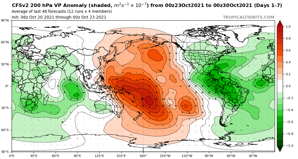
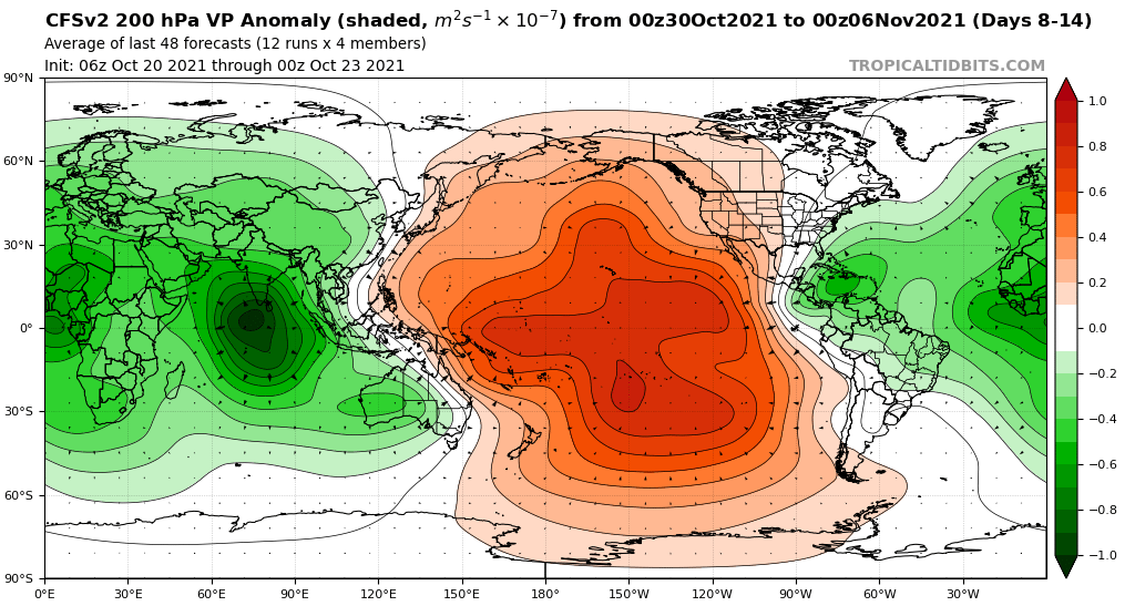
CPC says the La Nina base state has been weakening the MJO.
October has had a much lower MJO amplitude compared to the rest of the season.
A piece of the puzzle in explaining the earlier global lull IMO.
That also suggests one way a La Nina can limit Atlantic hurricane activity. Many models now keep the MJO within the null 'circle' as it crosses into the Western Hemisphere (meaning less basin amplification compared to a stronger MJO unweakened by Nina).
The MJO remained weak over the past few days, as the prior enhanced convective phase continues to destructively interfere with the La Nina base state over the Pacific.
October has had a much lower MJO amplitude compared to the rest of the season.
A piece of the puzzle in explaining the earlier global lull IMO.
That also suggests one way a La Nina can limit Atlantic hurricane activity. Many models now keep the MJO within the null 'circle' as it crosses into the Western Hemisphere (meaning less basin amplification compared to a stronger MJO unweakened by Nina).
1 likes
Kendall -> SLO -> PBC
Memorable Storms: Katrina (for its Florida landfall...) Wilma Matthew Irma
Memorable Storms: Katrina (for its Florida landfall...) Wilma Matthew Irma
-
Yellow Evan
- Professional-Met
- Posts: 15959
- Age: 25
- Joined: Fri Jul 15, 2011 12:48 pm
- Location: Henderson, Nevada/Honolulu, HI
- Contact:
Re: 2021 Indicators: SST's / SAL / MSLP / Shear / Steering / Instability / Sat Images
Just an experiment to see how activity this Atlantic season can be tied to the MJO and kelvin wave activity.
Generally lower phase #s favor the Atlantic.
Draw your own conclusions
JUNE -
The MJO is phase 7 with low amplitude (early in the month) propagating to phases 1 and 2 with moderate amplitude (last half of the month).
An amplifying kelvin wave coincides with tropical storm Bill. A suppressive kelvin wave coincides with tropical storm Claudette. An amplifying kelvin wave coincides with tropical storm Danny.
JULY -
The MJO is very rapidly propagating this month. It exits null and propagates through phases 3, 4, 5, 6, 7 and 8 with generally low amplitude.
An amplifying kelvin wave coincides with hurricane Elsa. Kelvin wave activity is strong through the rest of the month coinciding with no development.
AUGUST -
The MJO briefly dips back into null (early in the month) before rapidly amplifying. It enters phase 2 peaking at a high amplitude (middle of the month) before weakening back to null (end of the month).
Tropical storm Fred forms in a period of null kelvin wave activity. An amplifying kelvin wave coincides with hurricanes Grace and Henri. A suppressive kelvin wave coincides with no development. An amplifying kelvin wave coincides with hurricanes Ida and Larry and tropical storms Kate and Julian.
SEPTEMBER -
The MJO emerges into phase 3 peaking with a high amplitude (middle of the month) weakening into null before reemerging into phase 4 with moderate amplitude (end of the month).
A suppressive kelvin wave coincides with most of hurricane Larry's life. Tropical storm Mindy forms in a period of mostly null kelvin wave activity. An amplifying kelvin wave coincides with hurricane Nicholas and tropical storm Rose. A suppressive kelvin coincides with the formation of tropical storms Odette, Peter, and Sam. An amplifying kelvin wave coincides with almost all of Sam's life as well as tropical storms Teresa and Victor.
OCTOBER -
The MJO crosses into phase 5 with moderate to high amplitude (early in the month) and 6 with weakening amplitude (middle of the month) reentering null (to present).
The tail end of an amplifying kelvin wave coincides with hurricane Sam's last days. A suppressive kelvin wave coincides with no development. A period of null kelvin wave activity coincides with no development. A weak amplifying kelvin wave coincides with no development.
MJO analysis archive
VP Hovmoller mapping
5 likes
Kendall -> SLO -> PBC
Memorable Storms: Katrina (for its Florida landfall...) Wilma Matthew Irma
Memorable Storms: Katrina (for its Florida landfall...) Wilma Matthew Irma
-
Category5Kaiju
- Category 5
- Posts: 3413
- Age: 22
- Joined: Thu Dec 24, 2020 12:45 pm
- Location: Seattle
Re: 2021 Indicators: SST's / SAL / MSLP / Shear / Steering / Instability / Sat Images
Ok, so let's do a quick review on what is happening so far. Rick, originally projected to reach Category 3 strength, has succumbed to mid-level shear and is struggling to intensify as originally expected. With this year being a La Nina year, it is not surprising that mid-level shear in the EPAC has been quite unfriendly for systems. This imho is part of the reason why so many storms there have underperformed contrary to deep-level shear projections, warm ssts, high RH, etc. On the other hand, the Atlantic now has a lemon, and as many October systems are generated, this potential system will have subtropical and troughiness roots. Ensembles still are sniffing at activity in the WCAR in a few weeks, and some of the members seem to want to bring this system to potent strengths. If we get a long-lived TS or low-end hurricane from the current lemon and a strong early November WCAR hurricane, then it'll show that the La Nina we have currently is not broken and that the MJO amplitude and timing simply sucked for the Atlantic, which can explain why we have not seen activity in 3 weeks. Now as for why the MJO timing and amplitude were unfavorable for the Atlantic and the global tropics devoid of any major strength cyclones for the longest time...that's a different question that I think we still need to study after this season ends.
4 likes
Unless explicitly stated, all information covered in my posts is based on my opinions and observations. Please refer to a professional meteorologist or an accredited weather research agency otherwise, especially if serious decisions must be made in the event of a potentially life-threatening tropical storm or hurricane.
-
weeniepatrol

- Category 3

- Posts: 868
- Joined: Sat Aug 22, 2020 5:30 pm
- Location: WA State
Re: 2021 Indicators: SST's / SAL / MSLP / Shear / Steering / Instability / Sat Images
As has been continuously forecast this month, conditions are likely to become increasingly favorable soon.
https://twitter.com/yconsor/status/1452369202812235778
https://twitter.com/yconsor/status/1452370864473792523

https://twitter.com/yconsor/status/1452369202812235778
https://twitter.com/yconsor/status/1452370864473792523
1 likes
-
jconsor
- Professional-Met
- Posts: 532
- Joined: Mon Jun 30, 2008 9:31 pm
- Location: Jerusalem, Israel
- Contact:
Re: 2021 Indicators: SST's / SAL / MSLP / Shear / Steering / Instability / Sat Images
Long thread offering some thoughts on why the ITCZ and Caribbean activity have been suppressed up until now in Oct...
https://twitter.com/yconsor/status/1452331676537925635
...Why some forecasters are convinced the season is over in the Atlantic:
https://twitter.com/yconsor/status/1452368332678647809
...And how a significant change in the pattern is coming next two weeks that favors better chance of Caribbean activity:
https://twitter.com/yconsor/status/1452370864473792523
6 likes
Who is online
Users browsing this forum: 869MB, Beef Stew, chaser1, CyclonicFury, Hurricane2022, LarryWx, TheAustinMan, zzzh and 40 guests