The 12z guidance finally saw the GFS and NAM move into better agreement. Earlier, the differences between the two models were extreme in the cases of a few cities such as Boston. Based on the latest guidance, my initial estimates for the 12/2-4/2007 period (which is a storm total and includes both front-end and back-end snowfall amounts for areas for which such snowfall will be applicable) are as follows:
Albany: 1"-3"
Allentown: 1" or less
Bangor: 6"-12"
Boston: 1"-2"
Burlington: 4"-8"
Caribou: 5"-10"
Concord: 5"-10"
Harrisburg: 1"-2"
Hartford: 1" or less
New York City: 0.5" or less
Pittsburgh: 0.5" or less
Portland: 5"-10"
Providence: 1" or less
Worcester: 3"-6"
The December 2-4, 2007 Snowfall: Initial Estimates
Moderator: S2k Moderators
Forum rules
 The posts in this forum are NOT official forecast and should not be used as such. They are just the opinion of the poster and may or may not be backed by sound meteorological data. They are NOT endorsed by any professional institution or STORM2K.

The posts in this forum are NOT official forecast and should not be used as such. They are just the opinion of the poster and may or may not be backed by sound meteorological data. They are NOT endorsed by any professional institution or STORM2K.
-
donsutherland1
- S2K Analyst

- Posts: 2718
- Joined: Mon Sep 15, 2003 8:49 pm
- Location: New York
-
donsutherland1
- S2K Analyst
- Posts: 2718
- Joined: Mon Sep 15, 2003 8:49 pm
- Location: New York
At this time, some sizable differences still exist between the NAM and the GFS. The NAM continues to provide only a modest snowfall for northeastern sections of Maine (though the 12/2 0z run seems to moved toward the GFS in that area), while bringing a significant snowfall to such cities as Albany. At this time, I favor the GFS on account of its greater consistency. The ECMWF and GFS ensembles also add confidence to the GFS idea.
As a result, my final snowfall estimates for the December 2-4, 2007 timeframe are as follows:
Albany: 1”-3”
Allentown: 1”-3”
Bangor: 10”-16”
Boston: 1”-2”
Burlington: 8”-14”
Caribou: 7”-14”
Concord: 6”-12”
Harrisburg: 1” or less
Hartford: 1”-2”
New York City: 1” or less
Philadelphia: 1” or less
Pittsburgh: 0.5" or less
Portland: 5"-10"
Providence: 1”-2”
Toronto: 3”-6” (7.6 cm – 15.2 cm)
Worcester: 3"-6"
0 likes
-
tropicana

- Category 5

- Posts: 8056
- Joined: Sat Sep 27, 2003 6:48 pm
- Location: Niagara Falls, Ontario, Canada
- Contact:
Re: The December 2-4, 2007 Snowfall: Initial Estimates
yessss Don, that sounds about right for Toronto, on top of the snow, they are expecting a significant amount of freezing rain and ice accretion for Sunday, before it changes to rain, and heavy rain at that, now forecasters expect some 25 mm of rain on Sunday night alone! this is gonna be one major sloppy, wet storm for Toronto.
0 likes

-
tropicana
- Category 5
- Posts: 8056
- Joined: Sat Sep 27, 2003 6:48 pm
- Location: Niagara Falls, Ontario, Canada
- Contact:
Re: The December 2-4, 2007 Snowfall: Initial Estimates
Lots and lots of snow overnight in the Toronto region! It started shortly after 10pm .
0 likes
-
donsutherland1
- S2K Analyst
- Posts: 2718
- Joined: Mon Sep 15, 2003 8:49 pm
- Location: New York
Re: The December 2-4, 2007 Snowfall: Initial Estimates
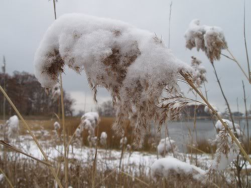
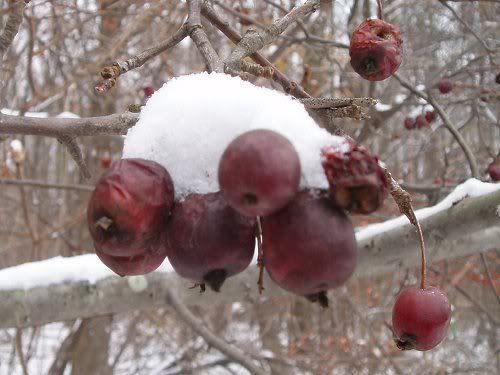
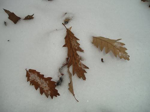
Some quick photos from earlier this morning:
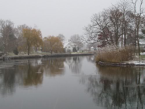
0 likes
-
donsutherland1
- S2K Analyst
- Posts: 2718
- Joined: Mon Sep 15, 2003 8:49 pm
- Location: New York
-
donsutherland1
- S2K Analyst
- Posts: 2718
- Joined: Mon Sep 15, 2003 8:49 pm
- Location: New York
Re: The December 2-4, 2007 Snowfall: Initial Estimates
That's good to hear, Tropicana. Some of the guidance suggested an additional round of accumulating snow later tonight and Monday once colder air returns. Hopefully, there won't be too much freezing rain before then.
0 likes
-
Stephanie

- S2K Supporter

- Posts: 23843
- Age: 63
- Joined: Thu Feb 06, 2003 9:53 am
- Location: Glassboro, NJ
Re: The December 2-4, 2007 Snowfall: Initial Estimates
As always, beautiful pictures don!
We've been having a mix of sleet and rain and now I see some very light snow.
Dangerous traveling weather. A good day for staying inside and putting up decorations, which is what I intend on doing.
We've been having a mix of sleet and rain and now I see some very light snow.
Dangerous traveling weather. A good day for staying inside and putting up decorations, which is what I intend on doing.
0 likes
-
Category 5

- Category 5
- Posts: 10074
- Age: 36
- Joined: Sun Feb 11, 2007 10:00 pm
- Location: New Brunswick, NJ
- Contact:
Re: The December 2-4, 2007 Snowfall: Initial Estimates
It looks about the same here as in Dons photos, but our snow fell at night.
Flurries are falling again right now.
Flurries are falling again right now.
0 likes
-
donsutherland1
- S2K Analyst
- Posts: 2718
- Joined: Mon Sep 15, 2003 8:49 pm
- Location: New York
Re: The December 2-4, 2007 Snowfall: Initial Estimates
Thanks Stephanie.
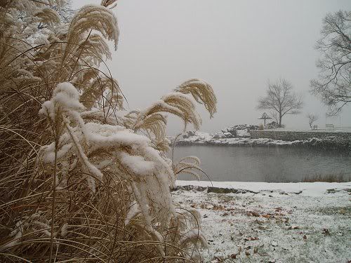
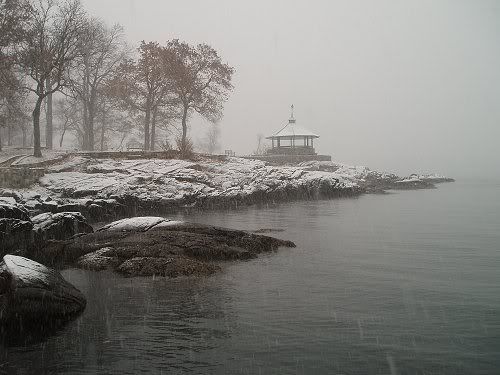
Some additional photos (taken early this afternoon):
Some additional photos (taken early this afternoon):
0 likes
-
tropicana
- Category 5
- Posts: 8056
- Joined: Sat Sep 27, 2003 6:48 pm
- Location: Niagara Falls, Ontario, Canada
- Contact:
Re: The December 2-4, 2007 Snowfall: Initial Estimates
awesome pics Don, we now have dense fog outside and somewhat milder temps with lots of snow on the ground and a band of heavy rain moving in, so that spells localized flooding tonight before the actual cold front goes through early in the morning...that will put an end to the melting but bring fresh problems, with strong north westerly winds gusting to 70 km/h, and snowsqualls...
i have put the summaries issued so far with this storm here...
Issued by Environment Canada Toronto at 4:35 PM EST Sunday 2 December
2007.
Major snowstorm from an intense Colorado low..
A Colorado low which intensified into a major winter storm has
dumped heavy snow across much of Ontario last night into this
morning. The snow mixed with ice pellets at times near the north
shore of Lake Huron into Sault Ste Marie.
While the first part of this storm has generally passed by to the
east another shot of heavy snow is expected tonight into Monday
primarily over northeastern Ontario as the storm centre itself
continues to deepen whilst passing over the Great Lakes and eastern
Ontario into New England by Monday.
The table below shows significant snow amounts at locations across
Northern Ontario from this snowstorm.
Location snow amounts
St Joseph Island 23 cm snow
Wawa 10 cm snow
Echo bay (N SS Marie) 2 cm snow
Sault Ste Marie 5-10 cm snow (EST'd)
Batchawana Bay 30 cm snow
Searchmont 14 cm snow
Silver water (15 km
E Gore Bay) 30 cm snow
Gore Bay 6 cm snow (EST'd)
Sudbury 4 cm snow
North Bay 4 cm snow
Kapsukasing 7 cm snow
Timmins 11 cm snow
Marathon 50 cm snow
Wawa 11 cm snow
Geraldton 12 cm snow
Thunder Bay airport 20 cm snow
Thunder Bay city 32 cm snow
Sioux Lookout 6 cm snow
Kenora 9 cm snow
Upsala 15 cm snow (EST'd)
Atikokan 15 cm snow (EST'd)
International Falls 15 cm snow (EST'd)
Weather summary for all of southern Ontario and
The national Capital region
Issued by Environment Canada Toronto at 4:30 PM EST Sunday 2 December
2007.
.Major winter storm dumps on Ontario...
A Colorado low which intensified into a major winter storm has
dumped heavy snow across much of Ontario last night into this
morning. The snow mixed with ice pellets and freezing rain over
Areas from Toronto and southwest..And has changed over to rain
southwest of Toronto now as milder air pays a short visit.
While the first part of this storm has generally passed by to the
east another shot of heavy snow is expected tonight over northern
parts of the district with some rain and mixed precipitation further
south near the lower Great Lakes as the storm centre tracks over ski
country and eastern Ontario into New England by Monday.
Numerous winter storm and freezing rain warnings remain in effect.
Intense snowsqualls are also expected to develop in a fresh blast of
frigid Arctic air over many areas southeast of Lake Huron and
Georgian Bay Monday..And snowsquall warnings are now in effect for
the snowbelts extending from London through Mount Forest and Barrie
to Port Severn. Some of the snowsqualls may come quite far inland
And may also affect areas like Hamilton..Kitchener and parts of
Toronto on Monday with blowing snow being a big issue here.
The table below shows final significant precipitation amounts and
types received at a number of locations across southern Ontario as of
4.30 PM. This report may be updated as more information becomes
available.
Location event description
Windsor 4 cm snow/ice pellets then frzg rn
Sarnia 2 cm snow/ice pellets then frzg rn
London 10 cm snow/ice pellets then frzg rn
Kitchener Stanley park 19 cm snow
Waterloo region airport 19 cm snow then freezing rain
Cambridge (shades mills) 14 cm snow
Fergus 16 cm snow
Guelph 17 cm snow
Mono Mills 16 cm snow
Georgetown 17 cm snow
Dundas 17.5 cm snow
Coldwater 6 cm snow
Newmarket 10.5 cm snow
Keswick 15 cm snow
Woodbridge 16 cm snow
Brampton 14 cm snow
Toronto Buttonville 8 cm snow then freezing rain
Toronto ec headquarters 12 cm snow then freezing rain
Toronto Pearson airport 12 cm snow
Toronto downtown 10-15 cm snow (EST'd)
Toronto east York 14.6 cm snow
Whitby 15 cm snow
Hamilton 14 cm snow then freezing rain
Hamilton richwill park 13 cm snow
Beamsville 10 cm snow
St. Catharines 14 cm snow
Welland 11 cm snow then some freezing rain
Wiarton 14 cm snow
Balaclava (N Meaford) 14 cm snow
Mount Forest 15-20 cm snow
Orillia 15 cm snow
Barrie 11 cm snow (EST'd)
Collingwood 10 cm snow (EST'd)
Muskoka 4 cm snow (EST'd)
Peterborough 10-15 cm snow (EST'd)
Trenton 4 cm snow
Bancroft 3 cm snow
Algonquin Park 2 cm snow
Please note that this summary contains the observations at
The time of broadcast and does not constitute an official
And final report of the weather events or the high
Impact events attributed to the weather events.
0 likes
-
Stephanie
- S2K Supporter
- Posts: 23843
- Age: 63
- Joined: Thu Feb 06, 2003 9:53 am
- Location: Glassboro, NJ
Re: The December 2-4, 2007 Snowfall: Initial Estimates
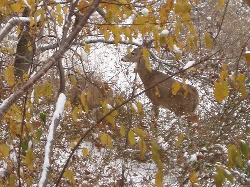
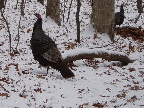
Love the deer and the wild turkeys!
NOW it feels like Christmas.
NOW it feels like Christmas.
0 likes
-
donsutherland1
- S2K Analyst
- Posts: 2718
- Joined: Mon Sep 15, 2003 8:49 pm
- Location: New York
-
donsutherland1
- S2K Analyst
- Posts: 2718
- Joined: Mon Sep 15, 2003 8:49 pm
- Location: New York
Re: The December 2-4, 2007 Snowfall: Initial Estimates
A quick update:
Through 5 pm this evening, daily snowfall totals included 1.6" at Allentown, 1.4" at New York City, and 0.7" at JFK (which broke the daily record of 0.1" set in 2003).
As of 12/3 2z warm air (> 0°C) was entrenched aloft in New York City and Bridgeport, and a warm layer was expanding over Hartford and Albany. The latest guidance suggests precipitation will likely change over to sleet, freezing rain, and/or plain rain beginning around 5z-7z in Boston and Worcester, 9z to 11z at Portland, and 11z-13z at Concord. Late in the afternoon or early in the evening, any mixed or liquid precipitation will likely change back to snow in Concord and Portland. Bangor and Caribou should experience quite a storm. Blizzard conditions are possible later tomorrow as the secondary system bombs out.
Hence, at this time, I'm reasonably comfortable with my final snowfall estimates. However, there is a possibility that total snowfall in Concord and Portland might wind up toward the lower part of my forecast range. Hartford likely won't achieve what I was thinking. All in all, things appear to be reasonably on course.
FWIW, my final estimates were:
Albany: 1”-3”
Allentown: 1”-3”
Bangor: 10”-16”
Boston: 1”-2”
Burlington: 8”-14”
Caribou: 7”-14”
Concord: 6”-12”
Harrisburg: 1” or less
Hartford: 1”-2”
New York City: 1” or less
Philadelphia: 1” or less
Pittsburgh: 0.5" or less
Portland: 5"-10"
Providence: 1”-2”
Toronto: 3”-6” (7.6 cm – 15.2 cm)
Worcester: 3"-6"
0 likes
-
donsutherland1
- S2K Analyst
- Posts: 2718
- Joined: Mon Sep 15, 2003 8:49 pm
- Location: New York
Re: The December 2-4, 2007 Snowfall: Initial Estimates
Verification:
The initial forecast saw 5/14 (36%) of sites fall within the expected forecast range. The largest error outside the range for those cities was 3.1" at Bangor. Every other error outside the range was 1.0" or less. The average error for those cities falling outside the forecast range was 1.0."
The final forecast fared quite well. In that forecast 10/16 (63%) of cities experienced snowfall within the forecast range. The largest error for those that had amounts outside the range was 1.0". The average error for such cities was 0.8".
From 12/1/2007 10:45 am:
Albany: 1"-3"; Actual: 0.3"; Error: 0.7"
Allentown: 1" or less; Actual: 1.6"; Error: 0.6"
Bangor: 6"-12"; Actual: 15.1"; Error: 3.1"
Boston: 1"-2"; Actual: 1.3"; Within range
Burlington: 4"-8"; Actual: 8.2"; Error: 0.2"
Caribou: 5"-10"; Actual: 10.5"; Error: 0.5"
Concord: 5"-10"; Actual: 7.3"; Within range
Harrisburg: 1"-2"; Actual: Trace; Error: 1.0"
Hartford: 1" or less; Actual: Trace; Within range
New York City: 0.5" or less; Actual: 1.4"; Error: 0.9"
Pittsburgh: 0.5" or less; Actual: 1.3"; Error: 0.8"
Portland: 5"-10"; Actual: 8.5"; Within range
Providence: 1" or less; Actual: Trace; Within range
Worcester: 3"-6"; Actual: 2.1"; Error: 0.9"
From: 12/1/2007 9:45 pm:
Albany: 1”-3”; Actual: 0.3"; Error: 0.7"
Allentown: 1”-3”; Actual: 1.6"; Within range
Bangor: 10”-16”; Actual: 15.1"; Within range
Boston: 1”-2”; Actual: 1.3"; Within range
Burlington: 8”-14”; Actual: 8.2"; Within range
Caribou: 7”-14”; Actual: 10.5"; Within range
Concord: 6”-12”; Actual: 7.3"; Within range
Harrisburg: 1” or less; Actual: Trace: Within range
Hartford: 1”-2”; Actual: Trace; Error: 1.0"
New York City: 1” or less; Actual: 1.4"; Error: 0.4"
Philadelphia: 1” or less; Actual: Trace; Within range
Pittsburgh: 0.5" or less; Actual: 1.3"; Error: 0.8"
Portland: 5"-10"; Actual: 8.5"; Within range
Providence: 1”-2”; Actual: Trace; Error: 1.0"
Toronto: 3”-6” (7.6 cm – 15.2 cm); Actual: 5.4" (13.6 cm)--started on 12/1; Within range
Worcester: 3"-6"; Actual: 2.1"; Error: 0.9"
0 likes
-
donsutherland1
- S2K Analyst
- Posts: 2718
- Joined: Mon Sep 15, 2003 8:49 pm
- Location: New York
Re: The December 2-4, 2007 Snowfall: Initial Estimates
Verification:
The initial forecast saw 5/14 (36%) of sites fall within the expected forecast range. The largest error outside the range for those cities was 3.1" at Bangor. Every other error outside the range was 1.0" or less. The average error for those cities falling outside the forecast range was 0.9."
The final forecast fared quite well. In that forecast 10/16 (63%) of cities experienced snowfall within the forecast range. The largest error for those that had amounts outside the range was 1.0". The average error for such cities was 0.7".
From 12/1/2007 10:45 am:
Albany: 1"-3"; Actual: 0.3"; Error: 0.7"
Allentown: 1" or less; Actual: 1.6"; Error: 0.6"
Bangor: 6"-12"; Actual: 15.1"; Error: 3.1"
Boston: 1"-2"; Actual: 1.3"; Within range
Burlington: 4"-8"; Actual: 8.2"; Error: 0.2"
Caribou: 5"-10"; Actual: 10.5"; Error: 0.5"
Concord: 5"-10"; Actual: 7.3"; Within range
Harrisburg: 1"-2"; Actual: Trace; Error: 1.0"
Hartford: 1" or less; Actual: Trace; Within range
New York City: 0.5" or less; Actual: 1.4"; Error: 0.9"
Pittsburgh: 0.5" or less; Actual: 0.7"; Error: 0.2"
Portland: 5"-10"; Actual: 8.5"; Within range
Providence: 1" or less; Actual: Trace; Within range
Worcester: 3"-6"; Actual: 2.1"; Error: 0.9"
From: 12/1/2007 9:45 pm:
Albany: 1”-3”; Actual: 0.3"; Error: 0.7"
Allentown: 1”-3”; Actual: 1.6"; Within range
Bangor: 10”-16”; Actual: 15.1"; Within range
Boston: 1”-2”; Actual: 1.3"; Within range
Burlington: 8”-14”; Actual: 8.2"; Within range
Caribou: 7”-14”; Actual: 10.5"; Within range
Concord: 6”-12”; Actual: 7.3"; Within range
Harrisburg: 1” or less; Actual: Trace: Within range
Hartford: 1”-2”; Actual: Trace; Error: 1.0"
New York City: 1” or less; Actual: 1.4"; Error: 0.4"
Philadelphia: 1” or less; Actual: Trace; Within range
Pittsburgh: 0.5" or less; Actual: 0.7"; Error: 0.2"
Portland: 5"-10"; Actual: 8.5"; Within range
Providence: 1”-2”; Actual: Trace; Error: 1.0"
Toronto: 3”-6” (7.6 cm – 15.2 cm); Actual: 5.4" (13.6 cm)--started on 12/1; Within range
Worcester: 3"-6"; Actual: 2.1"; Error: 0.9"
0 likes
Who is online
Users browsing this forum: No registered users and 136 guests